|
REFINE
Browse All : Railroad and Mining
1-9 of 9
Author
Keeler, William J.
Full Title
National Map Of The Territory Of The United States From The Mississippi River To The Pacific Ocean. Made by the authority of the Hon. O.H. Browning Secretary of the Interior. In the Office of the Indian Bureau Chiefly For Government Purposes under the direction of the Hon. N.G. Taylor Commisr. of Indian affairs & Hon. Chas. E. Mix Chief Clerk of the Indian Bureau; Compiled from authorized explorations of Pacific Rail Road Routes, Public Surveys, and other reliable data from the Departments from the Government at Washington, D.C., by W.J. Keeler, Civil Engineer. 1867. N. DuBois Draughtsman. J.F. Gedney, Lithographer, Engraver & Plate Printer, Washington, D.C. Entered ... 1867 by Wm. J. Keeler ... District of Columbia.
List No
4737.002
Author
Keeler, William J.
Full Title
National Map Of The Territory Of The United States From The Mississippi River To The Pacific Ocean. Made by the authority of the Hon. O.H. Browning Secretary of the Interior. In the Office of the Indian Bureau Chiefly For Government Purposes under the direction of the Hon. N.G. Taylor Commisr. of Indian affairs & Hon. Chas. E. Mix Chief Clerk of the Indian Bureau; Compiled from authorized explorations of Pacific Rail Road Routes, Public Surveys, and other reliable data from the Departments from the Government at Washington, D.C., by W.J. Keeler, Civil Engineer. 1867. N. DuBois Draughtsman. J.F. Gedney, Lithographer, Engraver & Plate Printer, Washington, D.C. Entered ... 1867 by Wm. J. Keeler ... District of Columbia.
List No
0397.002
Author
Keeler, William J.
Full Title
National Map Of The Territory Of The United States From The Mississippi River To The Pacific Ocean. Made by the authority of the Hon. O.H. Browning Secretary of the Interior. In the Office of the Indian Bureau Chiefly For Government Purposes under the direction of the Hon. N.G. Taylor Commisr. of Indian affairs & Hon. Chas. E. Mix Chief Clerk of the Indian Bureau; Compiled from authorized explorations of Pacific Rail Road Routes, Public Surveys, and other reliable data from the Departments from the Government at Washington, D.C., by W.J. Keeler, Civil Engineer. 1867. N. DuBois Draughtsman. J.F. Gedney, Lithographer, Engraver & Plate Printer, Washington, D.C. Entered ... 1867 by Wm. J. Keeler ... District of Columbia.
List No
4694.002
Author
Keeler, William J.
Full Title
(Title page to) (Covers to) Notes To Accompany Keeler's Map of the U.S. Territory, From The Mississippi River To The Pacific Ocean, Containing Authentic Information Connected With The Territories, And The Different Railroad Routes To The Pacific Ocean.
List No
4695.001
Author
Keeler, William J.
Full Title
(Composite text to) Notes To Accompany Keeler's Map of the U.S. Territory, From The Mississippi River To The Pacific Ocean, Containing Authentic Information Connected With The Territories, And The Different Railroad Routes To The Pacific Ocean.
List No
4695.002
Author
Amerine, C.H.
Full Title
C.H. Amerine's : Sectional map of Washington, Oregon, Idaho, and western Montana. Compiled from latest official data exploration and other sources. Compiled and published by C.H. Amerine, 1891. Copyrighted by C.H. Amerine, Tacoma, Wash. Photo - Litho by Schmidt Lable & Lith Co. S.F.
List No
6744.000
Note
Amerine published several maps of Washington, Oregon, Puget Sound and other areas of the Pacific Northwest, but this is his only multi-state map that we know of and it is not held in any libraries listed in WorldCat. Full color map, backed with linen. Shows capitals, county, towns, wagon roads, railroads, trails, reservations, light houses, blocks, subdivisions, etc. Includes explanation and table of township subdivision. Relief shown by hachures. Prime meridian is Washington.
Author
[Central Pacific Railroad Company, Union Pacific Railroad Company]
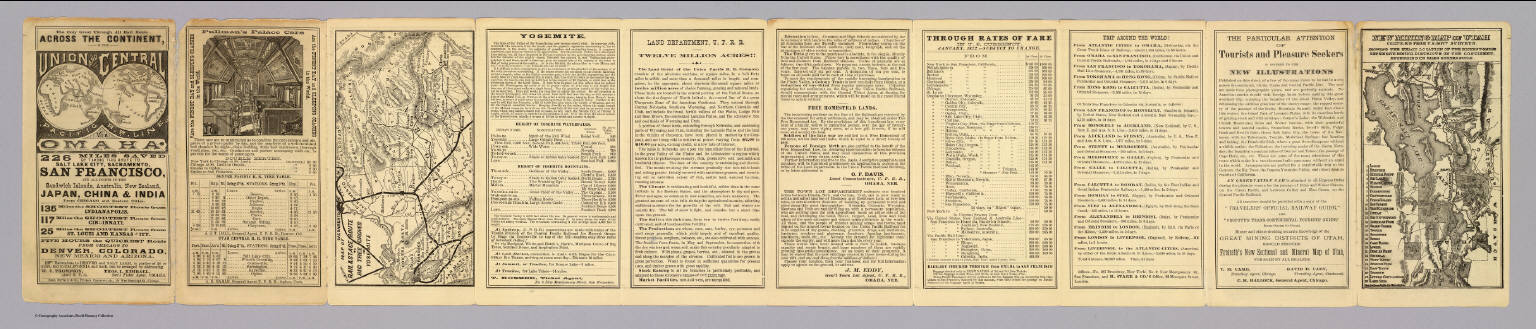
Full Title
(Text Page to) The only great through all rail route is the Union and Central Pacific R.R. line via Omaha ... Rand, McNally & Co., Printers Engravers, etc., 108 West Randolph St., Chicago ... Through time table, in effect January 1, 1872. (with) Map of rail & stage route to Big Tree Groves and Yosemite. (with) New mining map of Utah compiled from U.S. Govt. Surveys ... Nat. Railway Public Co., Philadelphia.
List No
4107.001
Note
10 p. on 1 sheet. Includes tables and text, an ad for Froiseth's new sectional and mineral map of Utah, and 2 maps. Big Tree Groves and Yosemite map at (ca. 1:1,900,000) scale. Utah map at (ca. 1:1,800,000). Relief shown by hachures. Utah map shows mining districts, etc.
Author
Bancroft, A.L.
Full Title
Bancroft's new map of California and Nevada : compiled from the latest and most reliable official sources and special surveys.
List No
6724.001
Note
Includes a unique birdseye view of Virginia City, Nevada. This map derives from H. H. Bancroft's 1867 Map of the Pacific States (see our 2549.000) but now focuses on just California and Nevada and the extensive and growing mining activity and transportation networks in those states. It is an entirely new engraving from the earlier map series and uses color lithography. With an inset map, Railway Map of the Pacific States.
Author
Loader, T. B.
Full Title
Under the patronage of His Majesty, T.B. Loader's scientific and commercial map of England and Wales in which are delineated the canals, rail-roads, & navigable rivers : the extent of the navigation of each river, with the elevations of the canals, together with the geology, and principal situations of the mineral productions. 1834. Published by T.B. Loader, 31 Bedford, St. Covent Garden. Mounted & colored by G. Cross, 98 Dean St. Soho.
List No
6887.000
Note
Color map, dissected and mounted on cloth ; 128 x 103, folded to 23 x 14. Shows rivers, canals, railroads, lighthouses, and roads. Includes geological references and ores, and explanation.
1-9 of 9
|