|
REFINE
Browse All : Railroad and Land Development
1-46 of 46
Author
Missouri, Kansas & Texas Railway
Full Title
OKLAHOMA, THE NEW STATE. - Sectional Map Of Oklahoma Traversed By The Missouri, Kansas & Texas Railway- Showing the crops adapted to each section with the elevation and annual rainfall...,
List No
15228.000
Note
Date estimated.
Author
[Commercial Club of Chicago. Civic Committee, Burnham, Daniel Hudson, 1846-1912, Bennett, Edward H. (Edward Herbert), 1874-1954, Moore, Charles]
Full Title
LXXIII. Chicago : Diagram of the city and surrounding country, showing railroad circuits, B, C, D and E, which are, or may become, tangent to the inner circuit (A).
List No
14346.059
Note
Map of Chicago within fifth chapter to Plan of Chicago. Shows railroads, roads, topography, lakes, drainage, shoreline and harbor. Relief shown with contour lines. With descriptive text: The diagram also shows the existing industries, and the probable trend of growth away from the center of the city. Includes a legend. Indexed, with key on facing page of descriptive text (66). Colored lithograph. Map is 21 x 17 cm, on sheet 31 x 24 cm. (Page number inferred.) Chapter spans pages 61-78.
Author
[Commercial Club of Chicago. Civic Committee, Burnham, Daniel Hudson, 1846-1912, Bennett, Edward H. (Edward Herbert), 1874-1954, Moore, Charles]
Full Title
LXXIV. Chicago : Diagram of the city center, showing the general location of existing freight yards and railroad lines, the present tunnel system and proposed circuit, and connections for all these services, running to the central clearing yards.
List No
14346.061
Note
Map of Chicago within fifth chapter to Plan of Chicago. Shows railroads, roads, shoreline and harbor. Includes a legend and bar scale. Colored lithograph. Map is 18 x 19 cm, on sheet 31 x 24 cm. (Page number inferred.) Chapter spans pages 61-78.
Author
[Commercial Club of Chicago. Civic Committee, Burnham, Daniel Hudson, 1846-1912, Bennett, Edward H. (Edward Herbert), 1874-1954, Moore, Charles]
Full Title
CXI. Chicago : Plan of the center of the city, showing the present street and boulevard system.
List No
14346.087
Note
Map of Chicago within seventh chapter to Plan of Chicago. Shows roads, railway stations, bridges, parks, drainage, shoreline and harbor. Includes a legend and bar scale. With descriptive text: The proposed additional arteries and street widenings (orange) ... Colored lithograph. Map is 22 x 18 cm, on sheet 31 x 24 cm. Chapter spans pages 99-118.
Author
[Commercial Club of Chicago. Civic Committee, Burnham, Daniel Hudson, 1846-1912, Bennett, Edward H. (Edward Herbert), 1874-1954, Moore, Charles, Guérin, Jules Vallée, 1866-1946]
Full Title
CXII. Chicago : Proposed boulevard to connect the north and south sides of the river; view looking north from Washington Street / painted for the Commercial Club by Jules Guerin.
List No
14346.088
Note
Bird's-eye view of Chicago within seventh chapter to Plan of Chicago. Shows buildings, roads, vegetation, fountain, horse-drawn buggies and figures. With descriptive text: The boulevard is raised to allow free flow of east-and-west teaming traffic under it, and both Michigan Avenue and Beaubien Court are raised to the boulevard level ... Colored lithograph. View is 23 x 18 cm, on sheet 31 x 24 cm. Chapter spans pages 99-118.
Author
[Commercial Club of Chicago. Civic Committee, Burnham, Daniel Hudson, 1846-1912, Bennett, Edward H. (Edward Herbert), 1874-1954, Moore, Charles, Guérin, Jules Vallée, 1866-1946]
Full Title
CXXI. Chicago : Proposed Twelfth Street boulevard at its intersections with Michigan Avenue and Ashland Avenue / painted for the Commercial Club by Jules Guerin.
List No
14346.094
Note
Bird's-eye view of Chicago within seventh chapter to Plan of Chicago. Shows a proposed railway terminal, as well as buildings, roads, bridges, parks, fountains and the Chicago River. With descriptive text: The proposed railway terminals are shown fronting on the Boulevard at its level, which is raised to allow north-and-south traffic to flow underneath ... Colored lithograph. View is 22 x 38 cm, on double sheet 31 x 48 cm. Chapter spans pages 99-118.
Author
[Commercial Club of Chicago. Civic Committee, Burnham, Daniel Hudson, 1846-1912, Bennett, Edward H. (Edward Herbert), 1874-1954, Moore, Charles, Guérin, Jules Vallée, 1866-1946]
Full Title
CXXII. Chicago : Railway station scheme west of the River between Canal and Clinton Streets, showing the relation with the Civic Center / painted for the Commercial Club by Jules Guerin.
List No
14346.095
Note
Bird's-eye view of Chicago within seventh chapter to Plan of Chicago. Shows a proposed railway and stations, as well as buildings, roads, bridges, parks, fountains and the Chicago River. With descriptive text: This plan provides for the railways at a level below that of the street, with the stations above. Colored lithograph. View is 17 x 36 cm, on double sheet 31 x 48 cm. Chapter spans pages 99-118.
Author
[Commercial Club of Chicago. Civic Committee, Burnham, Daniel Hudson, 1846-1912, Bennett, Edward H. (Edward Herbert), 1874-1954, Moore, Charles]
Full Title
CXXIX. Chicago : The business center of the city, within the First Circuit Boulevard, showing the proposed grand east-and-west axis and its relation to Grant Park and the yacht harbor; the railway terminals schemes on the south and west sides, and the Civic Center.
List No
14346.104
Note
Map of Chicago within seventh chapter to Plan of Chicago. Shows the city's business center with proposed roads, as well as park, harbor and railway terminals. Black and white lithograph. Map is 42 x 22 cm, on double sheet 48 x 31 cm. Chapter spans pages 99-118.
Author
Amerine, C.H.
Full Title
C.H. Amerine's : Sectional map of Washington, Oregon, Idaho, and western Montana. Compiled from latest official data exploration and other sources. Compiled and published by C.H. Amerine, 1891. Copyrighted by C.H. Amerine, Tacoma, Wash. Photo - Litho by Schmidt Lable & Lith Co. S.F.
List No
6744.000
Note
Amerine published several maps of Washington, Oregon, Puget Sound and other areas of the Pacific Northwest, but this is his only multi-state map that we know of and it is not held in any libraries listed in WorldCat. Full color map, backed with linen. Shows capitals, county, towns, wagon roads, railroads, trails, reservations, light houses, blocks, subdivisions, etc. Includes explanation and table of township subdivision. Relief shown by hachures. Prime meridian is Washington.
Author
Associated Railway Land Dept of Florida
Full Title
(Covers to) Township map of Peninsular Florida issued by the Associated Railway Land Department of Florida. 1890 ... Copyright, 1890, for the Associated Railway Land Department of Florida, By D.H. Elliott, General Land Agent. Matthews, Northrup & Co. Buffalo, New York.
List No
4100A
Note
Illustrated col. cover: Florida: map showing lands of the Associated Railway Land Department of Florida. Back cover: Florida: map illustrating its geographical position of the "Plant" and Jacksonville, Tampa & Key West systems.
Author
Associated Railway Land Dept of Florida
Full Title
(Title Page to) Township map of Peninsular Florida issued by the Associated Railway Land Department of Florida. 1890 ... Copyright, 1890, for the Associated Railway Land Department of Florida, By D.H. Elliott, General Land Agent. Matthews, Northrup & Co. Buffalo, New York.
List No
4100B
Note
List of companies and board of managers of the Department inside front cover.
Author
Associated Railway Land Dept of Florida
Full Title
Township map of Peninsular Florida issued by the Associated Railway Land Department of Florida. 1890 ... Copyright, 1890, for the Associated Railway Land Department of Florida, By D.H. Elliott, General Land Agent. Matthews, Northrup & Co., Buffalo, New York.
List No
4100.001
Note
Counties in outline color. Townships containing lands owned by the Department shown in green. Includes ill., diagram showing section numbering, etc. Prime meridian: Washington.
Author
Northern Pacific Railroad Company
Full Title
(Covers to) Map showing land grant of the Northern Pacific Railroad Co. in Western Washington and Northern Oregon. Corrected up to August 20, 1888 ... Matthews, Northrup & Co., Art-Printing Works, Buffalo, N.Y.
List No
5392A
Note
"Northern Pacific Country. View of Tacoma, Washington Territory. The Pacific Coast terminus of the Northern Pacific Railroad." Back cover: ... Ths sectional land map of western and central Washington ...
Author
Northern Pacific Railroad Company
Full Title
(Text Page to) Map showing land grant of the Northern Pacific Railroad Co. in Western Washington and Northern Oregon. Corrected up to August 20, 1888 ... Matthews, Northrup & Co., Art-Printing Works, Buffalo, N.Y.
List No
5392B
Note
3 p. on 1 sheet. Text, illustrations, "Map Of Washington, Northern Idaho & Oregon. Rand, McNally & Co., Chicago," fare table, climate tables, etc. Text entitled: Sectional land map showing the lands of the Northern Pacific Railroad Co. in Western Washington and Northern Oregon, with condensed information relating to the Northern Pacific country.
Author
Northern Pacific Railroad Company
Full Title
Map showing land grant of the Northern Pacific Railroad Co. in Western Washington and Northern Oregon. Corrected up to August 20, 1888 ... Matthews, Northrup & Co., Art-Printing Works, Buffalo, N.Y. (inset map) Northern Pacific Railroad and connections.
List No
5392.001
Note
Relief shown by hachures and spot heights. Shows lands and lands sold or transferred by N.P.R.R. and U.S. government, school sections, navigation line, mineral deposits, railroads, etc.
Author
[Commercial Club of Chicago. Civic Committee, Burnham, Daniel Hudson, 1846-1912, Bennett, Edward H. (Edward Herbert), 1874-1954, Moore, Charles]
Full Title
(Text Page to) Chapter III : Chicago the metropolis of the Middle West : Reasons for expecting continuous growth : The suburbs : A lakeside driveway along Lake Michigan : Connections between outlying cities : The building of good roads. (2)
List No
14346.033
Note
Third chapter to Plan of Chicago. Text begins: Chicago is the metropolis of the Middle West, a term popularly applied to the area known a century ago as the Territory Northwest of the Ohio River. No section of the country, except New England, has so distinct a history. These pages include a colored map: XXXV. Chicago, and diagram of Lake Michigan : Proposed roadway to connect all the towns along the shores of the Lake. Map is 15 x 9 cm, on sheet 31 x 24 cm. Chapter spans pages 31-42.
Author
[Commercial Club of Chicago. Civic Committee, Burnham, Daniel Hudson, 1846-1912, Bennett, Edward H. (Edward Herbert), 1874-1954, Moore, Charles]
Full Title
(Text Page to) Chapter IV. The Chicago park system : The movement for park extension : Playgrounds : Outlying park systems in London, Paris, Berlin, Vienna, and Boston : Proposed treatment of the Lake Michigan Shore : An outer park belt. (12) -- Chapter V. Transportation : A freight center : Grouping of passenger stations : A loop system. (1)
List No
14346.055
Note
On left - fourth chapter to Plan of Chicago. Text begins: Chicago, on becoming a city, chose for its motto Urbs in horto - a city set in a garden. Such indeed it then was, with the opalescent waters of the Lake at its front, and on its three sides the boundless prairie carpeted with waving grass bedecked with brilliant wild flowers. This page includes two black and white photographic views: LXVII. Chicago : Sherman Park : Field-house seen from the west side -- LXVIII. Chicago : Sherman Park : View of the open-air swimming pool. Views are each 6 x 10 cm, on sheet 31 x 24 cm. Chapter spans pages 43-60. On right - fifth chapter to Plan of Chicago. Text begins: Chicago has been made largely by the railroads, and its future prosperity is dependent upon them. With an historiated initial. This page includes a colored map: LXIX. Chicago : Diagram of a system of freight handling for land and water transportation, to be worked in conjunction with one another. Map includes explanatory notes. Map is 12 x 14 cm, on sheet 31 x 24 cm. Chapter spans pages 61-78.
Author
[Commercial Club of Chicago. Civic Committee, Burnham, Daniel Hudson, 1846-1912, Bennett, Edward H. (Edward Herbert), 1874-1954, Moore, Charles, Hotchkiss, C. W.]
Full Title
(Text Page to) Chapter V. Transportation : A freight center : Grouping of passenger stations : A loop system. (2)
List No
14346.056
Note
Fifth chapter to Plan of Chicago. Text begins: Chicago has been made largely by the railroads, and its future prosperity is dependent upon them. These pages include two colored maps: LXX. Chicago : Assembling-Interchange; diagrams accompanying the report of the committee : Diagram A -- Diagram B / C. W. Hotchkiss, Consulting Engineer. Maps include explanatory notes. Maps are each 13 x 9 cm, on sheet 31 x 24 cm. Chapter spans pages 61-78.
Author
[Commercial Club of Chicago. Civic Committee, Burnham, Daniel Hudson, 1846-1912, Bennett, Edward H. (Edward Herbert), 1874-1954, Moore, Charles]
Full Title
(Text Page to) Chapter V. Transportation : A freight center : Grouping of passenger stations : A loop system. (6)
List No
14346.062
Note
Fifth chapter to Plan of Chicago. Text begins: Chicago has been made largely by the railroads, and its future prosperity is dependent upon them. These pages include a colored map and two black and white photographic views: LXXV. Chicago : Diagram of the city, showing complete system of inner circuits -- LXXVI. Dresden : Viaduct and railway station (Hauptbahn-Hof) passing above the normal street level, illustrating the type proposed in the overhead scheme for railway stations west of the river -- LXXVII. Vienna : A railway viaduct passing over an important street. Map includes a legend, bar scale and explanatory notes. Map is 16 x 18, and views are 6 x 9 and 7 x 13 cm, on two sheets, together 31 x 48 cm. Chapter spans pages 61-78.
Author
[Commercial Club of Chicago. Civic Committee, Burnham, Daniel Hudson, 1846-1912, Bennett, Edward H. (Edward Herbert), 1874-1954, Moore, Charles]
Full Title
LXXX. Chicago : Diagram of the city center, showing the proposed arrangement of railroad passenger stations, the complete traction system, including rapid transit, subway, and elevated roads, and the circuit subway line.
List No
14346.065
Note
Map of Chicago within fifth chapter to Plan of Chicago. Shows railroads, roads, shoreline and harbor. Includes a legend and bar scale. With descriptive text: The last is designed, (A), to connect all railroad stations with one another ... Colored lithograph. Map is 18 x 19 cm, on sheet 31 x 24 cm. (Page number inferred.) Chapter spans pages 61-78.
Author
[Commercial Club of Chicago. Civic Committee, Burnham, Daniel Hudson, 1846-1912, Bennett, Edward H. (Edward Herbert), 1874-1954, Moore, Charles]
Full Title
(Text Page to) Chapter V. Transportation : A freight center : Grouping of passenger stations : A loop system. (9)
List No
14346.066
Note
Fifth chapter to Plan of Chicago. Text begins: Chicago has been made largely by the railroads, and its future prosperity is dependent upon them. These pages include two colored maps: LXXXI. Chicago : Railroad rights-of-way and properties in the center of city and the existing radial arteries -- LXXXII. Chicago : Diagram of general scheme of street circulation and parks in relation to the areas covered by industries and manufacturers (red) ... Maps are 16 x 10 and 15 x 18 cm, on two sheets, together 31 x 48 cm. Chapter spans pages 61-78.
Author
[Commercial Club of Chicago. Civic Committee, Burnham, Daniel Hudson, 1846-1912, Bennett, Edward H. (Edward Herbert), 1874-1954, Moore, Charles]
Full Title
(Text Page to) Chapter V. Transportation : A freight center : Grouping of passenger stations : A loop system. (10) -- Chapter VI. Natural features of Chicago : Necessity for comprehensive treatment of the street system : Streets within the city : The residence street, the avenue, and the boulevard : Street architecture : The streets of Chicago : Proposed new circuits. (1)
List No
14346.067
Note
On left - fifth chapter to Plan of Chicago. Text begins: Chicago has been made largely by the railroads, and its future prosperity is dependent upon them. This page includes a black and white photographic view: LXXXIII. The viaduct at Auteuil over the River Seine, Paris, France. View is 8 x 14 cm, on sheet 31 x 24 cm. Chapter spans pages 61-78. On right - sixth chapter to Plan of Chicago. Text begins: Chicago has two dominant natural features: the expanse of Lake Michigan, which stretches, unbroken by islands or peninsulas, to the horizon; and a corresponding area of land extending north, west, and south without hills or any marked elevation. With an historiated initial. This page includes a black and white view: LXXXIV. Chicago : The center of the city looking west, showing Grant Park, the harbor, and the civic center. Map is 10 x 15 cm, on sheet 31 x 24 cm. Chapter spans pages 79-98.
Author
[Commercial Club of Chicago. Civic Committee, Burnham, Daniel Hudson, 1846-1912, Bennett, Edward H. (Edward Herbert), 1874-1954, Moore, Charles]
Full Title
CX. Chicago : Plan of the complete system of street circulation; railway stations; parks, boulevard circuits and radial arteries; public recreation piers, yacht harbor, and the pleasure-boat piers; treatment of Grant Park; the main axis and the Civic Center, presenting the city as a complete organism in which all its functions are related one to another in such a manner that it will become a unit.
List No
14346.086
Note
Map of Chicago within seventh chapter to Plan of Chicago. Shows roads, railway stations, bridges, parks, drainage, shoreline and harbor. Black and white lithograph. Map is 23 x 18 cm, on sheet 31 x 24 cm. Chapter spans pages 99-118.
Author
Powell, John Wesley, 1834-1902.
Full Title
Map of the United States exhibiting the grants of lands made by the general government to aid in the construction of railroads and wagon roads. For explanation see chapter on "L̀and grants in aid of internal improvements". Julius Bien, Lithographer. (at head of title) Department of the Interior, U.S. Geographical and Geological Survey of the Rocky Mountain region, J.W. Powell in charge. (on upper margin) To accompany report on the Lands of the Arid Region of the U.S.
List No
2347.010
Note
Color map. Shows land grant s to railroads and wagon roads, and limit to grants. "The base chart was engraved for the Statistical atlas of the United States".
Author
Powell, John Wesley, 1834-1902.
Full Title
Rain chart of the United States : showing by isohyetal lines the distribution of the mean annual precipitation in rain and melted snow. This is a copy of the chart constructed for the Smithsonian Institution in 1868 by Charles A Schott ... Julius Bien, Lithographer. (at head of title) Department of the Interior, U.S. Geographical and Geological Survey of the Rocky Mountain region, J.W. Powell in charge. (on upper margin) To accompany report on the Lands of the Arid Region of the U.S.
List No
2347.011
Note
Color map. Showing isothermal lines. Includes explanation. "The base chart was engraved for the Statistical atlas of the United States".
Author
Northern Pacific Railroad Company
Full Title
(Covers to) Map showing surveyed portion of land grant of Northern Pacific Railroad Company from Jamestown, North Dakota, to Montana boundary line ... (1895)
List No
3131A
Author
Northern Pacific Railroad Company
Full Title
(Text Page to) Map showing surveyed portion of land grant of Northern Pacific Railroad Company from Jamestown, North Dakota, to Montana boundary line ... (1895)
List No
3131B
Note
6 p. on 1 sheet. Text, tables, illus. and small map: Northern Pacific Railroad leased lines and connections.
Author
Northern Pacific Railroad Company
Full Title
Map showing surveyed portion of land grant of Northern Pacific Railroad Company from Jamestown, North Dakota, to Montana boundary line ... (1895)
List No
3131.001
Note
Shows railroads, counties, quarter sections, railroad lands sold and for sale, government lands settled and unoccupied, and those reserved for schools, Indian and military reservations, etc.
Author
Texas and Pacific Railway
Full Title
(Covers to:) The Texas and Pacific Railway. The shortest line to the great cotton grain and stock regions of Texas ... Woodward, Tiernan & Hale, Printers, St. Louis.
List No
3254A
Note
Illustrated folded title.
Author
Texas and Pacific Railway
Full Title
The Texas and Pacific Railway. The shortest line to the great cotton grain and stock regions of Texas ... Woodward, Tiernan & Hale, Printers, St. Louis.
List No
3254B
Note
Illustrated folded title, timetables and text. Uncolored. Folded to 20 x 9 cm. Timetables "in effect June 1st, 1878."
Author
Texas and Pacific Railway
Full Title
A geographically correct map of the state of Texas. Published by the Texas & Pacific Railway Company. Compiled from actual surveys and containing all changes in lines of counties up to Sept. 1st, 1876. (1878)
List No
3254.001
Note
Col. map. Relief shown by hachures. Shows the line of the railroad through Texas and its land grants. Colton did a similar map for the Texas & Pacific in 1873 (Modelski 578). This issue seems simpler and more of a land promotion. Covers also part of Indian Territory. Prime meridians: Greenwich and Washington.
Author
[Central Pacific Railroad Company, Union Pacific Railroad Company]
Full Title
(Covers to) Union and Central Pacific Railroad Line. The Great American Over-land Route. Rand, McNally & Co., Printers, Engravers and Electrotypers, 77 and 79 Madison Street, Chicago.
List No
3256A
Note
A joint Union and Central Pacific Railway timetable and land promotion. Also has promotions for the Black Hills and Leadville Mines, Yosemite, Arizona and Montana, Pullman cars, and Pacific Mail Steamers to Japan, China and India. Plus illustrations of 24 scenes along the route. Map has printed outline color by state. Folded into light blue paper self wrappers 18x10.
Author
[Central Pacific Railroad Company, Union Pacific Railroad Company]
Full Title
(Text Page to) Union and Central Pacific Railroad Line. The Great American Over-land Route. Rand, McNally & Co., Printers, Engravers and Electrotypers, 77 and 79 Madison Street, Chicago.
List No
3256B
Note
Timetables, 24 ills. along the route, promotions for the Black Hills and Leadville Mines, Yosemite, Arizona and Montana, Pullman cars, and Pacific Mail Steamers to Japan, China and India.
Author
[Central Pacific Railroad Company, Union Pacific Railroad Company]
Full Title
New map of the American Overland Route showing its connections, and land grants of 30,000,000 acres. Rand, McNally & Co., Chicago. (1879)
List No
3256.001
Note
Relief shown by hachures. Covers most of the United States. Shows also stage routes and proposed railroads.
Author
[Colton, G.W. & C.B., Illinois Central Railroad Company]
Full Title
Railroad Map Of Illinois. One Million Acres Of Land For sale by the Illinois Central Railroad Company, all within fifteen miles of the Railroad, and extending the entire length of the state, North and South ... For further information, address, Land Commissioner, Illinois Central Railroad Company, Chicago, Ills. Entered ... 1861, by G. Woolworth Colton ... New York.
List No
3274.000
Note
Land sale promotion. Map shows railroad lands in red. Probably made specially by Colton for the railroad - this is not the atlas map (it is larger) and it has the simplicity of a railroad map - it shows the stations along the route which is delineated by a thick black line. The text promotes the wonders of Illinois for farming. Explanatory remarks includes Illinois population 1840-1860, School fund, and Central land sale. Prime meridian is Greenwich.
Author
Florida East Coast Railway
Full Title
Map of the Peninsula of Florida and Adjacent Islands. Published by the Land Department, Florida East Coast Railway. This map is absolutely correct in all the Geographical details, and every Railroad is shown in its proper location. The Matthews Northrup Co., Complete Engraving And Printing Works, Buffalo, N.Y. (inset) West Indies, Central America And South America. (inset) Bahama Islands
List No
3893.000
Note
Map is not dated and the date is estimated from Modelski (which states that the railroad was completed to Miami in 1896, as shown on this edition). The sections are shown adjacent to the railroad, presumably for potential land purchasers. Color cadastral map. County borders printed in yellow, railroads in red; water in full blue.
Author
Texas Land and Immigration Company
Full Title
(Covers to:) Map of the state of Texas. Woodward, Tiernan & Hale, Map Engr's St. Louis. Texas Land and Immigration Co. St. Louis, Mo. (1876)
List No
5049A
Author
Texas Land and Immigration Company
Full Title
(Verso of:) Map of the state of Texas. Woodward, Tiernan & Hale, Map Engr's St. Louis. Texas Land and Immigration Co. St. Louis, Mo. (1876)
List No
5049B
Note
Ten p. text on 1 sheet.
Author
Texas Land and Immigration Company
Full Title
Map of the state of Texas. Woodward, Tiernan & Hale, Map Engr's St. Louis. Texas Land and Immigration Co. St. Louis, Mo. (1876)
List No
5049.001
Note
Lithographed map. Counties in outline color, Indian Territory in solid color. Relief shown by hachures. Shows railroads, roads, ship routes, settlements, Indian reservations and nations in Indian Territory, etc. Prime meridians: Greenwich and Washington. "Texas Land and Immigration Co., St. Louis, Mo." in side and lower margins.
Author
[International & Great Northern Railroad, Rand McNally and Company]
Full Title
(Covers to:) The Lone Star guide descriptive of counties on the line of the International and Great Northern Railroad of Texas ... Woodward, Tiernan & Hale, Printers, St. Louis.
List No
5051A
Note
Yellow paper cover title.
Author
[International & Great Northern Railroad, Rand McNally and Company]
Full Title
Map of the International and Great Northern Railroad. Lone (Star) route and connections. Woodward, Tiernan & Hale, Map Engravers, St. Louis. Rand, McNally & Co, Map Engr's Chicago. (1878)
List No
5051.001
Note
Black and white map covering Arkansas, Louisiana, Mississippi and parts of Texas, Indian Territory, Missouri, and adjoining states. Relief shown by hachures. The sides and verso of the folding map have timetables and promotional text: "Good news from Texas..." With the stamp of Henry H. Hannan, Swan Creek, Ohio.
Author
Great Northern Railway Company (U.S.)
Full Title
(Covers to) Das Red River Thal in Minnesota und Nord-Dakota. Das beste und fruchtbarste Land in America. Die Getreidekammer der Welt. Ein gutes Heim und Reichthum fur Deutsche Landwirthe.
List No
5236A
Author
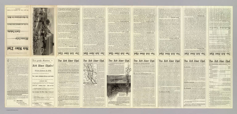
Great Northern Railway Company (U.S.)
Full Title
(Text Page to) Das Red River Thal in Minnesota und Nord-Dakota. Das beste und fruchtbarste Land in America. Die Getreidekammer der Welt. Ein gutes Heim und Reichthum fur Deutsche Landwirthe.
List No
5236B
Note
18 p. on 1 sheet. Includes small map: Die setten Linien reprasentiren die Great Northern Eisenbahn. Includes view: Ausicht des Beihhofes auf der Farm von Johann Birkholz in Gast Grand Forks, Minn, nach einer Photographie.
Author
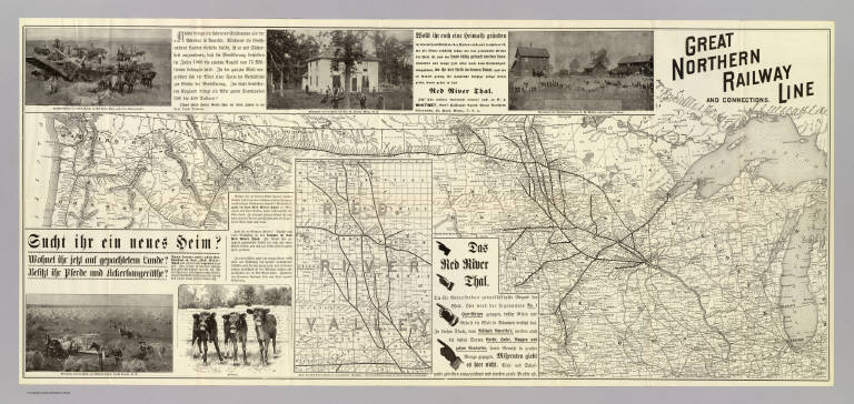
Great Northern Railway Company (U.S.)
Full Title
Great Northern Railway line and connections. (with:) Karte des Red River Thales in vergrossertem Masstabe. Knight, Leonard & Co., engr's., Chi(cago)
List No
5236.001
Note
Relief shown by hachures. Covers area from lake Michigan to Washington and Oregon. Inset map at (ca. 1:1,520,640) scale. Includes views and text. Maps in English, text and captions in German.
Author
St. Louis-San Francisco Railway Company
Full Title
(Text Page to) St. Louis and San Francisco Railway befordert Fracht und Passagiere zu den billigsten Preisen! nach allen Punkten in Sud-West Missouri, dem Sudlichen Kansas und Texas ... Woodward, Tiernan & Hale, Printers, St. Louis.
List No
5242B
Note
(6) p. on 1 sheet. Timetable (in English), farmland information, descriptive text, self wrapper.
Author
St. Paul, Minneapolis & Manitoba Railway Company.
Full Title
St. Paul. Minneapolis & Manitoba Railway. Commences at St. Paul, Minneapolis and Duluth, and runs northwest through the timbered districts of Minnesota to the Red River Valley ... Engraved by American Bank Note Co., N.Y. This map corrected according to government surveys, January 1, 1885. (inset) Map of the St. Paul, Minneapolis & Manitoba Railway, and connections.
List No
5250.001
Note
Col. map. Shows sections, counties, etc. Inset map covers area from Lake Michigan to N. & S. Dakota and Nebraska and north to Manitoba.
1-46 of 46
|