|
REFINE
Browse All : Railroad and Guide Book of United States from 1834
1-5 of 5
Author
Tanner, Henry S.
Full Title
(Covers to) A Brief Description of the Canals and Railroads of the United States; Comprehending notices of all the most important works of Internal Improvement throughout the Several States. By H.S. Tanner. Philadelphia: Published by the Author. November, 1834.
List No
4050.001
Note
First edition. Modelski: " One of the earliest general maps of the eastern United States showing railroads in operation." The issue of the map with Armroyd's "Connected View..." is an earlier state - it does not show railroads in South Carolina and Alabama that appear on this state of the map. This is the second state of the first edition, with two plates of canal profiles added. Map in outline color by state and measuring 44x57. With paper covered boards. Title page printed on the gold colored covers.
Author
Tanner, Henry S.
Full Title
Map of the Canals & Railroads of the United States, Reduced from the large map of the U.S. by H.S. Tanner.
List No
4050.002
Note
First edition. Modelski: " One of the earliest general maps of the eastern United States showing railroads in operation." The issue of the map with Armroyd's "Connected View..." is an earlier state - it does not show railroads in South Carolina and Alabama that appear on this state of the map. This is the second state of the first edition, with two plates of canal profiles added. Map in outline color by state and measuring 44x57. With paper covered boards. Title page printed on the gold colored covers.
Author
Tanner, Henry S.
Full Title
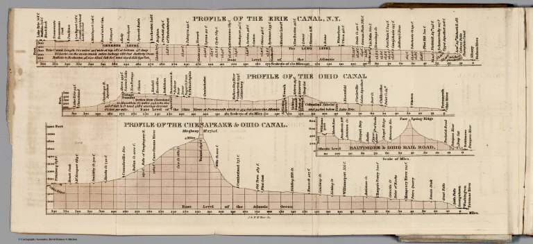
Profiles of Erie, Ohio, and Chesapeake Canals, Ohio Railroad
List No
4050.003
Note
First edition. Modelski: " One of the earliest general maps of the eastern United States showing railroads in operation." The issue of the map with Armroyd's "Connected View..." is an earlier state - it does not show railroads in South Carolina and Alabama that appear on this state of the map. This is the second state of the first edition, with two plates of canal profiles added. Map in outline color by state and measuring 44x57. With paper covered boards. Title page printed on the gold colored covers.
Author
Tanner, Henry S.
Full Title
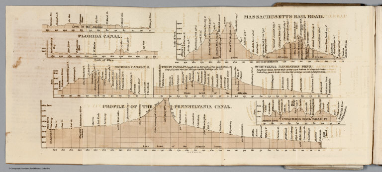
Profiles of the Massachusetts Railroad, Florida Canal, Morris Canal N.J., Union Canal, Schuylkill Navigation, Pennsylvania Canal, Columbia Railroad.
List No
4050.004
Note
First edition. Modelski: " One of the earliest general maps of the eastern United States showing railroads in operation." The issue of the map with Armroyd's "Connected View..." is an earlier state - it does not show railroads in South Carolina and Alabama that appear on this state of the map. This is the second state of the first edition, with two plates of canal profiles added. Map in outline color by state and measuring 44x57. With paper covered boards. Title page printed on the gold colored covers.
Author
Tanner, Henry S.
Full Title
The Traveller's Guide or Map Of The Roads, Canals & Rail Roads of the United States. With the distances from place to place by H.S. Tanner. " On bottom of map: "Published by H.S. Tanner. Entered ... 1834, by H.S. Tanner ... Pennsylvania. (to accompany) The American Traveller; Or Guide Through the United States. Containing Brief Notices of the Several States, Cities, Principal Towns ... By H.S. Tanner. Philadelphia: Published by the Author, Shakespeare Buildings. 1834. (on verso) Entered ... 1834, by H.S. Tanner ... Pennsylvania.
List No
4542.003
Note
Outline color map, has 17 inset maps of cities or regions. The first edition. This is the only edition of the map to have a date on it; we can find no other changes to the maps in the 1836 and 1837 editions. Includes references to Capitals, important towns ... roads canals and railroads. In the 1842 edition many of the upper left inset maps are dropped to allow better coverage of Iowa. There is an extra map of Pennsylvania tipped in that is the Anthony Finley 1834 double page atlas map of Pennsylvania, but with Tanner's name as publisher and printed on thin folding paper. Included are four small maps of Baltimore, Philadelphia, New York and Boston. With a catalogue of Tanner's works. Linen covered boards with label affixed to the cover with title, "Tanner's American Traveller, or Guide Through the United States."
1-5 of 5
|