|
Author
Leahy, J.F.
Full Title
(Covers to) Leahy's Hotel Guide and Railway Distance Maps of America. The Green book, It Shows the Way. Published by American Hotel Register Company. Leahy Building 228-234 W. Ontario street, Chicago, Ill. Established Nearly Half a Century. Established Nearly Half Century. Revised Edition No. 59, Copyrighted Jan. 1934. Price of this book complete $5.00. Subscription, Five Years .... $20.00, Combined Guide and Map of any Individual State 25 cents.
List No
0425.001
Note
A guide to accompany the revised edition No. 59 of Leahy's Hotel Guide and Railway Distance Maps of America. It lists the Hotels of the town with the number of rooms of each, their rates per day and the population of the town. It includes the name of the railroads entering the town and where the town can be found on the map. Maps of each state are opposite the State lists of towns and hotels making it easy and convenient to refer from the one to the other. The maps give the railroad distance between towns. The Guide includes the Provinces of Canada, as well as the United States. The railroad distance maps of Europe, Mexico, South and Central America ... Maps printed without color, Railroad lines shown in red on some maps. The Guidebook is bound in Green paper covers with title in gold: Leahy's Hotel Guide and R.R. Distance Maps. Southern Pacific Lines.
Author
Leahy, J.F.
Full Title
Leahy's Railway Distance Map of the United States. Published by American Hotel Register Company. Leahy Building 228-234 W. Ontario street, Chicago. (Copyrighted).
List No
0425.002
Note
Map printed without color. The railway lines shown in red and back. All lines represent the train routes and the mileage between points.
Author
Leahy, J.F.
Full Title
Leahy's Railway Distance Map of the United States. Published by American Hotel Register Company. Leahy Building 228-234 W. Ontario street, Chicago. (Copyrighted).
List No
0425.003
Note
Map printed without color. Showing the Eastern States. The railway lines shown in red and back. All lines represent the train routes and the mileage between points.
Author
Leahy, J.F.
Full Title
Leahy's Railway Distance Map of the United States. Published by American Hotel Register Company. Leahy Building 228-234 W. Ontario street, Chicago. (Copyrighted).
List No
0425.004
Note
Map printed without color. The railway lines shown in red and back. All lines represent the train routes and the mileage between points.
Author
Leahy, J.F.
Full Title
(Title Page to) Leahy's Hotel Guide and Railway Distance Maps of America. The Green book, It Shows the Way. Published by American Hotel Register Company. Leahy Building 228-234 W. Ontario street, Chicago, Ill. Established Nearly Half Century. Revised Edition No. 59, Copyrighted Jan. 1934. Price of this book, complete $5.00. Subscription, Five Years .... $20.00, Combined Guide and Map of any Individual State 25 cents.
List No
0425.005
Note
A guide to accompany the revised edition No. 59 of Leahy's Hotel Guide and Railway Distance Maps of America. It lists the Hotels of the town with the number of rooms of each, their rates per day and the population of the town. It includes the name of the railroads entering the town and where the town can be found on the map. Maps of each state are opposite the State lists of towns and hotels making it easy and convenient to refer from the one to the other. The maps give the railroad distance between towns. The Guide includes Index, explanation of Hotel listing, and explanatory map, the Provinces of Canada, as well as the United States. The railroad distance maps of Europe, Mexico, South and Central America ... Maps printed without color, Railroad lines shown in red on some maps. The Guidebook is bound in Green paper covers with title in gold: Leahy's Hotel Guide and R.R. Distance Maps. Southern Pacific Lines.
Author
Leahy, J.F.
Full Title
Chart of Distances Between Important Cities of the United States.
List No
0425.147
Note
Table of distances "compiled from the war Department's Official table of distances, and other reliable sources."
Author
Leahy, J.F.
Full Title
Leahy's Railway Distance Map of the United States. Published by American Hotel Register Company. Leahy Building 228-234 W. Ontario street, Chicago. (Copyrighted).
List No
0425.148
Note
Map printed without color. The railway lines shown in red and back. All lines represent the train routes and the mileage between points.
Author
Leahy, J.F.
Full Title
Leahy's Railway Distance Map of the United States. Published by American Hotel Register Company. Leahy Building 228-234 W. Ontario street, Chicago. (Copyrighted).
List No
0425.149
Note
Map printed without color. The railway lines shown in red and back. All lines represent the train routes and the mileage between points.
Author
Leahy, J.F.
Full Title
Leahy's Railway Distance Map of the United States. Published by American Hotel Register Company. Leahy Building 228-234 W. Ontario street, Chicago. (Copyrighted).
List No
0425.150
Note
Map printed without color. The railway lines shown in red and back. All lines represent the train routes and the mileage between points.
Author
Mitchell, Samuel Augustus
Full Title
(Covers to) Mitchell's Compendium Of The Internal Improvements Of The United States; Comprising General Notices Of All The Most Important Canals and Rail-Roads... Philadelphia: Published By Mitchell & Hinman, No. 6, North-Fifth Street. 1838. (on verso) Entered ... 1835, by Mitchell & Hinman ... Pennsylvania. Stereotyped by John Fagan ... Philadelphia. (with) Mitchell's Map Of The United States Showing the Principal Travelling, Turnpike and Common Roads ... Philadelphia: Published By S. Augustus Mitchell. 1838. Sold by Mitchell & Hinman. No. 6 North Fifth Street. Entered ... 1835, by S. Augustus Mitchell... Pennsylvania. (with 8 inset maps).
List No
0521.001
Note
The second edition. No obvious changes noted from the 1835 edition of the map. Full color. 84 Page book is bound into patterned teal blue cloth covers with "The American Traveller, And Guide Through The United States." on cover label. Four page catalogue of Mitchell's maps.
Author
Mitchell, Samuel Augustus
Full Title
(Title Page to) Mitchell's Compendium Of The Internal Improvements Of The United States; Comprising General Notices Of All The Most Important Canals and Rail-Roads... Philadelphia: Published By Mitchell & Hinman, No. 6, North-Fifth Street. 1838. (on verso) Entered ... 1835, by Mitchell & Hinman ... Pennsylvania. Stereotyped by John Fagan ... Philadelphia. (with) Mitchell's Map Of The United States Showing the Principal Travelling, Turnpike and Common Roads ... Philadelphia: Published By S. Augustus Mitchell. 1838. Sold by Mitchell & Hinman. No. 6 North Fifth Street. Entered ... 1835, by S. Augustus Mitchell... Pennsylvania. (with 8 inset maps).
List No
0521.002
Note
The second edition. No obvious changes noted from the 1835 edition of the map. Full color. 84 Page book is bound into patterned teal blue cloth covers with "The American Traveller, And Guide Through The United States." on cover label. Four page catalogue of Mitchell's maps.
Author
Mitchell, Samuel Augustus
Full Title
Mitchell's Map Of The United States Showing the Principal Travelling, Turnpike and Common Roads ... Philadelphia: Published By S. Augustus Mitchell. 1838. Sold by Mitchell & Hinman. No. 6 North Fifth Street. Entered ... 1835, by S. Augustus Mitchell... Pennsylvania. (with 8 inset maps. (with) Mitchell's Compendium Of The Internal Improvements Of The United States; Comprising General Notices Of All The Most Important Canals and Rail-Roads... Philadelphia: Published By Mitchell & Hinman, No. 6, North-Fifth Street. 1838. (on verso) Entered ... 1835, by Mitchell & Hinman ... Pennsylvania. Stereotyped by John Fagan ... Philadelphia.
List No
0521.003
Note
The second edition. No obvious changes noted from the 1835 edition of the map. Full color. 84 Page book is bound into patterned teal blue cloth covers with "The American Traveller, And Guide Through The United States." on cover label. Four page catalogue of Mitchell's maps.
Author
Tanner, Henry S.
Full Title
The Travellers Guide Or Map Of the Roads, Canals & Rail Roads Of The United States, With the Distances From Place To Place. By H.S. Tanner. (to accompany) The American Traveller; Or Guide Through the United States. Containing Brief Notices of the Several States, Cities, Principal Towns ... Third Edition. By H.S. Tanner. Philadelphia: Published by the Author, No. 51 South Third Street. 1837. (on verso) Entered ... 1834, by H.S. Tanner ... Pennsylvania.
List No
0978.003
Note
Full color map. With References and 18 inset maps. 3rd edition; 1st was 1834; map unchanged. Catalog of Tanner's works at end of book. 144 page Guide Book with four maps of city plans. Fifth map is a large colored map entitled, "The Traveller's Guide or Map of the Roads, Canals & Rail Roads of the United States, With the distances from place to place by H.S. Tanner." At bottom of map, "Entered ... 1834, by H.S. Tanner ... Pennsylvania." Bound with linen embossed with a rose pattern. Label on cover states, "Tanner's American Traveller, or Guide through the United States."
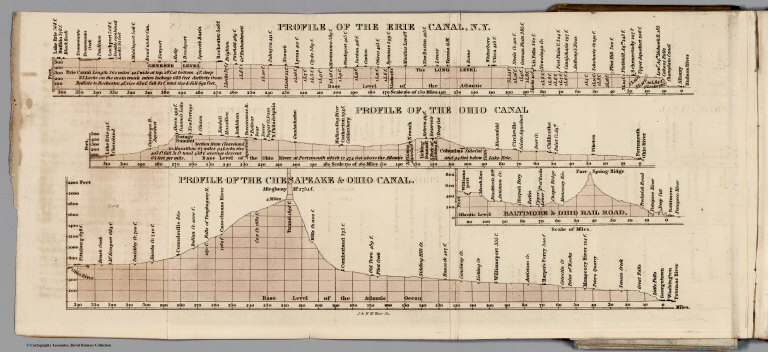
Author
Tanner, Henry S.
Full Title
Profile of the Erie Canal N.Y. ; Profile of the Ohio Canal ; Profile of the Chesapeake & Ohio Canal. (with inset profile) Baltimore & Ohio railroad. (to accompany) A Description of the Canals and Railroads of the United States.
List No
0979.005
Note
Three profiles on one page.
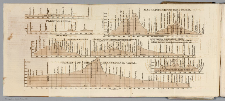
Author
Tanner, Henry S.
Full Title
Florida Canal ; Morris Canal N. J. ; Union Canal Pa. ; Schuylkill Navigation Penn. ; Profile of the Pennsylvania Canal. (with inset profile) Columbia railroad Pa. (to accompany) A Description of the Canals and Railroads of the United States.
List No
0979.006
Note
Six profiles on one page.
Author
Tanner, Henry S.
Full Title
Map of the canals & railroads of the United States, reduced from the large map of the U.S. by H. S. Tanner. Published T. R. Tanner & J. Disturnell, 124 Broadway, New York, 1840. Engraved by J. Knight. Entered ... 1840, by T.R. Tanner ... Pennsylvania. ( inset continuation map of ) South part of Florida ; Chesapeake & Delaware Canal ; Dismal Swamp Canal ; Welland Canal ; Lehigh navigation.
List No
0979.010
Note
Map shows canals and roads in color, folded into brown cloth covered boards. With one inset and four cross sections. Includes explanation. Prime meridian is Washington.
Author
Tanner, Henry S.
Full Title
The Travellers Guide or Map of the Roads, Canals & Rail Roads of The United States, With the Distances From Place to Place. By H.S. tanner 1844. Published by H.S. Tanner... Philadelphia. Entered ... 1834, by H.S. Tanner ... Pennsylvania.
List No
0983.003
Note
Full color map. With references and 11 insets showing major cities. Rail Roads are hand colored in red. Bookplate of Tanner's Map Store, N.Y. 144 page Guide Book. Includes maps and reference guides. New copyright notice of 1844 indicating that this is a very late edition; the map is changed from the earlier editions but is still copyright 1834, as in the earlier editions. Full color map entitled, "The Travellers Guide or Map of The Roads, Canals & Rail Roads of the United States, With the distances from place to place by H.S. Tanner 1844." at bottom, "Entered ... 1834, by H.S. Tanner ... Pennsylvania." Bound in linen with gild title, "Tanner's American Traveller or Guide through the United States with Maps, Plans &c."
Author
Atchison, Topeka and Santa Fe Railway Co.
Full Title
Santa Fe - The Atchison, Topeka and Santa Fe Railway Co. and Connections.
List No
12045.024
Note
Two page (four panel) spread.
Author
Tanner, Henry S.
Full Title
(Covers to) The American Traveller; Or Guide Through the United States. Containing Brief Notices of the Several States, Cities, Principal Towns ... Alphabetically arranged, Eighth Edition. By H.S. Tanner. Philadelphia: Published by H. Tanner, Jr. New York: T.R. Tanner. 1842. (on verso) Entered ... 1839, by H.S. Tanner ... Pennsylvania. With direct References to the accompanying Map "The Travellers Guide or Map of the Roads, Canals, and Railways of the United States. With the distances from place to place by H.S. Tanner.
List No
2528.001
Note
8th edition, published by H. Tanner Jr. in Philadelphia and T.R. Tanner in New York, both presumably H. Tanner senior's sons. The large map appears unchanged from the 1840 edition. Large outline color map bound in back entitled, "The Travellers Guide or Map of the Roads, Canals & Rail Roads of the United States, With the distances from place to place by H.S. Tanner." At bottom of map, "Entered ... 1834, by H.S. Tanner ... Pennsylvania." Book bound with linen and with title embossed on cover, "Tanner's American Traveller or Guide through the United States with Maps, Plans &c. 1842."
Author
Tanner, Henry S.
Full Title
(Title Page to) The American Traveller; Or Guide Through the United States. Containing Brief Notices of the Several States, Cities, Principal Towns ... Alphabetically arranged, Eighth Edition. By H.S. Tanner. Philadelphia: Published by H. Tanner, Jr. New York: T.R. Tanner. 1842. (on verso) Entered ... 1839, by H.S. Tanner ... Pennsylvania. With direct References to the accompanying Map "The Travellers Guide or Map of the Roads, Canals, and Railways of the United States. With the distances from place to place by H.S. Tanner.
List No
2528.002
Note
8th edition, published by H. Tanner Jr. in Philadelphia and T.R. Tanner in New York, both presumably H. Tanner senior's sons. The large map appears unchanged from the 1840 edition. Large outline color map bound in back entitled, "The Travellers Guide or Map of the Roads, Canals & Rail Roads of the United States, With the distances from place to place by H.S. Tanner." At bottom of map, "Entered ... 1834, by H.S. Tanner ... Pennsylvania." Book bound with linen and with title embossed on cover, "Tanner's American Traveller or Guide through the United States with Maps, Plans &c. 1842."
Author
Tanner, Henry S.
Full Title
The Travellers Guide or Map of the Roads, Canals, and Railways of the United States. With the Distances from Place to Place by H.S. Tanner. (with inset 8 inset maps). (with the accompanying guide) The American Traveller; Or Guide Through the United States. Containing Brief Notices of the Several States, Cities, Principal Towns ... Alphabetically arranged, Eighth Edition. By H.S. Tanner. Philadelphia: Published by H. Tanner, Jr. New York: T.R. Tanner. 1842. (on verso) Entered ... 1839, by H.S. Tanner ... Pennsylvania.
List No
2528.003
Note
8th edition, published by H. Tanner Jr. in Philadelphia and T.R. Tanner in New York, both presumably H. Tanner senior's sons. The large map appears unchanged from the 1840 edition. Large outline color map bound in back entitled, "The Travellers Guide or Map of the Roads, Canals & Rail Roads of the United States, With the distances from place to place by H.S. Tanner." At bottom of map, "Entered ... 1834, by H.S. Tanner ... Pennsylvania." Book bound with linen and with title embossed on cover, "Tanner's American Traveller or Guide through the United States with Maps, Plans &c. 1842."
Author
Tanner, Henry S.
Full Title
Baltimore
List No
2528.004
Note
8th edition, published by H. Tanner Jr. in Philadelphia and T.R. Tanner in New York, both presumably H. Tanner senior's sons. The large map appears unchanged from the 1840 edition. Large outline color map bound in back entitled, "The Travellers Guide or Map of the Roads, Canals & Rail Roads of the United States, With the distances from place to place by H.S. Tanner." At bottom of map, "Entered ... 1834, by H.S. Tanner ... Pennsylvania." Book bound with linen and with title embossed on cover, "Tanner's American Traveller or Guide through the United States with Maps, Plans &c. 1842."
Author
Tanner, Henry S.
Full Title
Boston
List No
2528.005
Note
8th edition, published by H. Tanner Jr. in Philadelphia and T.R. Tanner in New York, both presumably H. Tanner senior's sons. The large map appears unchanged from the 1840 edition. Large outline color map bound in back entitled, "The Travellers Guide or Map of the Roads, Canals & Rail Roads of the United States, With the distances from place to place by H.S. Tanner." At bottom of map, "Entered ... 1834, by H.S. Tanner ... Pennsylvania." Book bound with linen and with title embossed on cover, "Tanner's American Traveller or Guide through the United States with Maps, Plans &c. 1842."
Author
Tanner, Henry S.
Full Title
New York
List No
2528.006
Note
8th edition, published by H. Tanner Jr. in Philadelphia and T.R. Tanner in New York, both presumably H. Tanner senior's sons. The large map appears unchanged from the 1840 edition. Large outline color map bound in back entitled, "The Travellers Guide or Map of the Roads, Canals & Rail Roads of the United States, With the distances from place to place by H.S. Tanner." At bottom of map, "Entered ... 1834, by H.S. Tanner ... Pennsylvania." Book bound with linen and with title embossed on cover, "Tanner's American Traveller or Guide through the United States with Maps, Plans &c. 1842."
Author
Tanner, Henry S.
Full Title
Philadelphia and Environs
List No
2528.007
Note
8th edition, published by H. Tanner Jr. in Philadelphia and T.R. Tanner in New York, both presumably H. Tanner senior's sons. The large map appears unchanged from the 1840 edition. Large outline color map bound in back entitled, "The Travellers Guide or Map of the Roads, Canals & Rail Roads of the United States, With the distances from place to place by H.S. Tanner." At bottom of map, "Entered ... 1834, by H.S. Tanner ... Pennsylvania." Book bound with linen and with title embossed on cover, "Tanner's American Traveller or Guide through the United States with Maps, Plans &c. 1842."
Author
Tanner, Henry S.
Full Title
Manuscript Drawing
List No
2528.008
Note
8th edition, published by H. Tanner Jr. in Philadelphia and T.R. Tanner in New York, both presumably H. Tanner senior's sons. The large map appears unchanged from the 1840 edition. Large outline color map bound in back entitled, "The Travellers Guide or Map of the Roads, Canals & Rail Roads of the United States, With the distances from place to place by H.S. Tanner." At bottom of map, "Entered ... 1834, by H.S. Tanner ... Pennsylvania." Book bound with linen and with title embossed on cover, "Tanner's American Traveller or Guide through the United States with Maps, Plans &c. 1842."
Author
[Mitchell, Samuel Augustus, Drake, Ira S.]
Full Title
(Covers to) Mitchell's New Traveller's Guide Through The United States, Containing The Principal Cities, Towns &c. ... Illustrated By An Accurate Map Of The United States. Philadelphia: Thomas, Cowperthwait & Co. 1849. (on verso) Entered ... 1848, by Thomas, Cowperthwait & Co. ... Pennsylvania. Stereotyped by J. Fagan. Printed by Smith & Peters. (with map) Mitchell's New Traveller's Guide Through The United States, Showing the Rail Roads, Canals, Stage Roads &c. ... Drawn and Engraved by Ira S. Drake. Philadelphia 1849 Published by Thomas, Cowperthwait & Co. Entered ... 1848, by Thomas, Cowperthwait, & Co. ... Pennsylvania. (with 5 inset maps).
List No
2766.001
Note
This is a major revision of the guide with an entirely new map by Ira S. Drake (about whom we find nothing) with five inset maps entitled - "Vicinity Of Niagara Falls", "Map Of The Copper Mine Region", "Map of the Gold and Quicksilver district of California", "Map of the Maritime and Overland Routes to California", and "Map Of New England Or Eastern States". The map emphasis on the California gold rush is clear, although the 128 pages of expanded text do not yet list routes to the gold fields, while they do add routes west from St. Louis and Independence. The main map is larger than the earlier Mitchell/Young maps, but shows roughly the same area on a somewhat larger scale. An "Advertisement" (actually a preface) dated Nov. 1, 1848, states: "The following work is similar in design to 'Mitchell's Traveller's Guide,' first published about twelve years ago, and which has been so extremely patronized, that it may be safely asserted no book of the kind ever printed in this country has met with so wide a circulation." Covers are black stamped leather with "Mitchell's New Traveller's Guide Through The United States" and a beautiful illustration of a steam boat and train stamped in gilt. Map is outline color. Catalogue of Thomas, Cowperthwait School Books included in the text.
Author
[Mitchell, Samuel Augustus, Drake, Ira S.]
Full Title
(Title Page to) Mitchell's New Traveller's Guide Through The United States, Containing The Principal Cities, Towns &c. ... Illustrated By An Accurate Map Of The United States. Philadelphia: Thomas, Cowperthwait & Co. 1849. (on verso) Entered ... 1848, by Thomas, Cowperthwait & Co. ... Pennsylvania. Stereotyped by J. Fagan. Printed by Smith & Peters. (with map) Mitchell's New Traveller's Guide Through The United States, Showing the Rail Roads, Canals, Stage Roads &c. ... Drawn and Engraved by Ira S. Drake. Philadelphia 1849 Published by Thomas, Cowperthwait & Co. Entered ... 1848, by Thomas, Cowperthwait, & Co. ... Pennsylvania. (with 5 inset maps).
List No
2766.002
Note
This is a major revision of the guide with an entirely new map by Ira S. Drake (about whom we find nothing) with five inset maps entitled - "Vicinity Of Niagara Falls", "Map Of The Copper Mine Region", "Map of the Gold and Quicksilver district of California", "Map of the Maritime and Overland Routes to California", and "Map Of New England Or Eastern States". The map emphasis on the California gold rush is clear, although the 128 pages of expanded text do not yet list routes to the gold fields, while they do add routes west from St. Louis and Independence. The main map is larger than the earlier Mitchell/Young maps, but shows roughly the same area on a somewhat larger scale. An "Advertisement" (actually a preface) dated Nov. 1, 1848, states: "The following work is similar in design to 'Mitchell's Traveller's Guide,' first published about twelve years ago, and which has been so extremely patronized, that it may be safely asserted no book of the kind ever printed in this country has met with so wide a circulation." Covers are black stamped leather with "Mitchell's New Traveller's Guide Through The United States" and a beautiful illustration of a steam boat and train stamped in gilt. Map is outline color. Catalogue of Thomas, Cowperthwait School Books included in the text.
Author
[Mitchell, Samuel Augustus, Drake, Ira S.]
Full Title
Mitchell's New Traveller's Guide Through The United States, Showing the Rail Roads, Canals, Stage Roads &c. ... Drawn and Engraved by Ira S. Drake. Philadelphia 1849 Published by Thomas, Cowperthwait & Co. Entered ... 1848, by Thomas, Cowperthwait, & Co. ... Pennsylvania. (with 5 inset maps). (with guide book) Mitchell's New Traveller's Guide Through The United States, Containing The Principal Cities, Towns &c. ... Illustrated By An Accurate Map Of The United States. Philadelphia: Thomas, Cowperthwait & Co. 1849. (on verso) Entered ... 1848, by Thomas, Cowperthwait & Co. ... Pennsylvania. Stereotyped by J. Fagan. Printed by Smith & Peters.
List No
2766.003
Note
This is a major revision of the guide with an entirely new map by Ira S. Drake (about whom we find nothing) with five inset maps entitled - "Vicinity Of Niagara Falls", "Map Of The Copper Mine Region", "Map of the Gold and Quicksilver district of California", "Map of the Maritime and Overland Routes to California", and "Map Of New England Or Eastern States". The map emphasis on the California gold rush is clear, although the 128 pages of expanded text do not yet list routes to the gold fields, while they do add routes west from St. Louis and Independence. The main map is larger than the earlier Mitchell/Young maps, but shows roughly the same area on a somewhat larger scale. An "Advertisement" (actually a preface) dated Nov. 1, 1848, states: "The following work is similar in design to 'Mitchell's Traveller's Guide,' first published about twelve years ago, and which has been so extremely patronized, that it may be safely asserted no book of the kind ever printed in this country has met with so wide a circulation." Covers are black stamped leather with "Mitchell's New Traveller's Guide Through The United States" and a beautiful illustration of a steam boat and train stamped in gilt. Map is outline color. Catalogue of Thomas, Cowperthwait School Books included in the text. Prime meridian is Washington D.C.
Author
Mitchell, Samuel Augustus
Full Title
Mitchell's Map Of The United States Showing the Principal Travelling, Turnpike and Common Roads ... Philadelphia: Published By S. Augustus Mitchell. 1835. Sold by Mitchell & Hinman No. 6 North Fifth Street. Entered ... 1835, by S. Augustus Mitchell... Pennsylvania. (with 8 inset maps). (with text) Mitchell's Compendium Of The Internal Improvements Of The United States; Comprising General Notices Of All The Most Important Canals and Rail-Roads... Philadelphia: Published By Mitchell & Hinman, No. 6 North-Fifth Street. 1835. (on verso) Entered ... 1835, by Mitchell & Hinman ... Pennsylvania. Stereotyped by John Fagan ... Philadelphia.
List No
2869.003
Note
1st edition. This guide is scarcer than Mitchell's Traveller's Guide. The outline color map is very similar to the Traveller's Guide Map - it is probably from the same plate, but covers slightly more area, has eight inset maps (the Traveller's map drops the Hartford /New Haven inset and adds two - Niagara Falls and New Orleans) instead of nine, and has a table of distances below the title. The 84 page text in this guide is a descriptive listing of Canals, Railroads, etc.; the Traveller's Guide text functions as a route book and was certainly more generally useful and had many more editions. There was only one other edition of this Compendium, in 1838 (see our #521). The map was issued separately in 1839 (see our #4950) and a printing on silk was issued in 1835 (see our #4544). Book is bound into black leather covers with "Mitchell's Compendium Of Canals & Railroads" and a decorative border stamped in gilt. Four page catalogue of Mitchell's maps. Prime meridians are Washington D.C. and Greenwich.
Author
Tanner, Henry S.
Full Title
The Traveller's Guide or Map Of The Roads, Canals & Rail Roads of the United States. With the distances from place to place by H.S. Tanner." On bottom of map: "Entered ... 1834, by H.S. Tanner ... Pennsylvania. (to accompany) The American Traveller; Or Guide Through the United States. Containing Brief Notices of the Several States, Cities, Principal Towns ... With tables of Distances, ... Second Edition. By H.S. Tanner. Philadelphia: Published by the Author, Shakespeare Buildings. 1836. (on verso) Entered ... 1836, By H.S. Tanner ... Pennsylvania.
List No
3181.004
Note
Colored map, has 17 inset maps of cities or regions. Second edition. Three pages of views are added. Maps include four city plans. Bound in tan linen with a mostly removed label which carried the title.
Author
Smith, J. Calvin
Full Title
(Covers to) The Illustrated Hand-Book, A New Guide for Travelers Through The United States of America... Embellished with 125 highly finished Engravings. Accompanied By A Large and Accurate Map. By J. Calvin Smith. New York: Published By Sherman & Smith, 122 Broadway, N.W. Cor. Cedar-St. 1847. Entered ...1846, by Sherman & Smith ... (with) A New Map For Travellers Through the United States of America Showing the Railroads, Canals & Stage Roads, With The Distances, by J. Calvin Smith. Published by Sherman & Smith, New-York. 1846. Entered ... 1846, by J. Calvin Smith ... (inset) Map Of Oregon Northern California Santa Fe &c. (4 additional inset maps).
List No
3689.001
Note
Second edition of the book, first edition of the map. The first edition of the book and map was 1846; Howes lists editions of 1847, 1848, 1849, 1850 - undoubtedly there were others (see our 1856). The map was also issued separately (see our #4954, 4955). On the map, five vignettes and a decorative border are in the best Smith engraved style. 233 pages of text, black cloth patterned boards 14.5x9.5, with "The Illustrated Hand Book For Travelers Through The United States Of America" in gilt and blind stamped. Map colored in outline.
Author
Smith, J. Calvin
Full Title
(Title Page to) The Illustrated Hand-Book, A New Guide for Travelers Through The United States of America... Embellished with 125 highly finished Engravings. Accompanied By A Large and Accurate Map. By J. Calvin Smith. New York: Published By Sherman & Smith, 122 Broadway, N.W. Cor. Cedar-St. 1847. Entered ...1846, by Sherman & Smith ... (with) A New Map For Travellers Through the United States of America Showing the Railroads, Canals & Stage Roads, With The Distances, by J. Calvin Smith. Published by Sherman & Smith, New-York. 1846. Entered ... 1846, by J. Calvin Smith ... (inset) Map Of Oregon Northern California Santa Fe &c. (4 additional inset maps).
List No
3689.002
Note
Second edition of the book, first edition of the map. The first edition of the book and map was 1846; Howes lists editions of 1847, 1848, 1849, 1850 - undoubtedly there were others (see our 1856). The map was also issued separately (see our #4954, 4955). On the map, five vignettes and a decorative border are in the best Smith engraved style. 233 pages of text, black cloth patterned boards 14.5x9.5, with "The Illustrated Hand Book For Travelers Through The United States Of America" in gilt and blind stamped. Map colored in outline.
Author
Smith, J. Calvin
Full Title
The Illustrated Hand-Book, A New Guide for Travelers Through The United States of America... Embellished with 125 highly finished Engravings. Accompanied By A Large and Accurate Map. By J. Calvin Smith. New York: Published By Sherman & Smith, 122 Broadway, N.W. Cor. Cedar-St. 1847. Entered ...1846, by Sherman & Smith ... (with) A New Map For Travellers Through the United States of America Showing the Railroads, Canals & Stage Roads, With The Distances, by J. Calvin Smith. Published by Sherman & Smith, New-York. 1846. Entered ... 1846, by J. Calvin Smith ... (inset) Map Of Oregon Northern California Santa Fe &c. (4 additional inset maps).
List No
3689.003
Note
Second edition of the book, first edition of the map. The first edition of the book and map was 1846; Howes lists editions of 1847, 1848, 1849, 1850 - undoubtedly there were others (see our 1856). The map was also issued separately (see our #4954, 4955). On the map, five vignettes and a decorative border are in the best Smith engraved style. 233 pages of text, black cloth patterned boards 14.5x9.5, with "The Illustrated Hand Book For Travelers Through The United States Of America" in gilt and blind stamped. Map colored in outline.
Author
Tanner, Henry S.
Full Title
(Covers to) A Brief Description of the Canals and Railroads of the United States; Comprehending notices of all the most important works of Internal Improvement throughout the Several States. By H.S. Tanner. Philadelphia: Published by the Author. November, 1834.
List No
4050.001
Note
First edition. Modelski: " One of the earliest general maps of the eastern United States showing railroads in operation." The issue of the map with Armroyd's "Connected View..." is an earlier state - it does not show railroads in South Carolina and Alabama that appear on this state of the map. This is the second state of the first edition, with two plates of canal profiles added. Map in outline color by state and measuring 44x57. With paper covered boards. Title page printed on the gold colored covers.
Author
Tanner, Henry S.
Full Title
Map of the Canals & Railroads of the United States, Reduced from the large map of the U.S. by H.S. Tanner.
List No
4050.002
Note
First edition. Modelski: " One of the earliest general maps of the eastern United States showing railroads in operation." The issue of the map with Armroyd's "Connected View..." is an earlier state - it does not show railroads in South Carolina and Alabama that appear on this state of the map. This is the second state of the first edition, with two plates of canal profiles added. Map in outline color by state and measuring 44x57. With paper covered boards. Title page printed on the gold colored covers.
Author
Tanner, Henry S.
Full Title
Profiles of Erie, Ohio, and Chesapeake Canals, Ohio Railroad
List No
4050.003
Note
First edition. Modelski: " One of the earliest general maps of the eastern United States showing railroads in operation." The issue of the map with Armroyd's "Connected View..." is an earlier state - it does not show railroads in South Carolina and Alabama that appear on this state of the map. This is the second state of the first edition, with two plates of canal profiles added. Map in outline color by state and measuring 44x57. With paper covered boards. Title page printed on the gold colored covers.
Author
Tanner, Henry S.
Full Title
Profiles of the Massachusetts Railroad, Florida Canal, Morris Canal N.J., Union Canal, Schuylkill Navigation, Pennsylvania Canal, Columbia Railroad.
List No
4050.004
Note
First edition. Modelski: " One of the earliest general maps of the eastern United States showing railroads in operation." The issue of the map with Armroyd's "Connected View..." is an earlier state - it does not show railroads in South Carolina and Alabama that appear on this state of the map. This is the second state of the first edition, with two plates of canal profiles added. Map in outline color by state and measuring 44x57. With paper covered boards. Title page printed on the gold colored covers.
Author
[Mitchell, Samuel Augustus, Drake, Ira S.]
Full Title
(Covers to) Mitchell's New Traveller's Guide Through The United States, Containing The Principal Cities, Towns &c. ... Illustrated By An Accurate Map Of The United States. Philadelphia: Thomas, Cowperthwait & Co. 1853. (on verso) Entered ... 1848, by Thomas, Cowperthwait & Co. ... Pennsylvania. Stereotyped by J. Fagan. Printed by Smith & Peters. (with map) Mitchell's New Traveller's Guide Through The United States, Showing the Rail Roads, Canals, Stage Roads &c. ... Drawn and Engraved by Ira S. Drake. Philadelphia 1854. Published by Thomas, Cowperthwait & Co. Entered ... 1848, by Thomas, Cowperthwait, & Co. ... Pennsylvania. (with 5 inset maps).
List No
4196.001
Note
The text is not changed from the 1850 edition, nor are any major changes noted on the map from the 1851 edition map (even though this map is dated 1854). The catalogue of Thomas, Cowperthwait is enlarged from the 1850 edition, with an excellent description of the Mitchell New Universal Atlas: "The results of the latest geographical and nautical discoveries are to be found on the Maps, including those of the most recent date by Wilkes, Nicollet, and Fremont." Outline color. Bound in black stamped leather covers with "Mitchell's New Traveller's Guide Through The United States" and a beautiful illustration of a steam boat and train stamped in gilt.
Author
[Mitchell, Samuel Augustus, Drake, Ira S.]
Full Title
(Title Page to) Mitchell's New Traveller's Guide Through The United States, Containing The Principal Cities, Towns &c. ... Illustrated By An Accurate Map Of The United States. Philadelphia: Thomas, Cowperthwait & Co. 1853. (on verso) Entered ... 1848, by Thomas, Cowperthwait & Co. ... Pennsylvania. Stereotyped by J. Fagan. Printed by Smith & Peters. (with map) Mitchell's New Traveller's Guide Through The United States, Showing the Rail Roads, Canals, Stage Roads &c. ... Drawn and Engraved by Ira S. Drake. Philadelphia 1854. Published by Thomas, Cowperthwait & Co. Entered ... 1848, by Thomas, Cowperthwait, & Co. ... Pennsylvania. (with 5 inset maps).
List No
4196.002
Note
The text is not changed from the 1850 edition, nor are any major changes noted on the map from the 1851 edition map (even though this map is dated 1854). The catalogue of Thomas, Cowperthwait is enlarged from the 1850 edition, with an excellent description of the Mitchell New Universal Atlas: "The results of the latest geographical and nautical discoveries are to be found on the Maps, including those of the most recent date by Wilkes, Nicollet, and Fremont." Outline color. Bound in black stamped leather covers with "Mitchell's New Traveller's Guide Through The United States" and a beautiful illustration of a steam boat and train stamped in gilt.
Author
[Mitchell, Samuel Augustus, Drake, Ira S.]
Full Title
Mitchell's New Traveller's Guide Through The United States, Containing The Principal Cities, Towns &c. ... Illustrated By An Accurate Map Of The United States. Philadelphia: Thomas, Cowperthwait & Co. 1853. (on verso) Entered ... 1848, by Thomas, Cowperthwait & Co. ... Pennsylvania. Stereotyped by J. Fagan. Printed by Smith & Peters. (with map) Mitchell's New Traveller's Guide Through The United States, Showing the Rail Roads, Canals, Stage Roads &c. ... Drawn and Engraved by Ira S. Drake. Philadelphia 1854. Published by Thomas, Cowperthwait & Co. Entered ... 1848, by Thomas, Cowperthwait, & Co. ... Pennsylvania. (with 5 inset maps).
List No
4196.003
Note
Map in outline color. Titled Mitchell's New Traveller's Guide Through The United States, Showing the Rail Roads, Canals, Stage Roads &c. ... Drawn and Engraved by Ira S. Drake. Philadelphia 1854. Five inset maps include: Map of the Copper Mine Region, ... Maritime And Overland Routes to California, ... Gold And Quicksilver District of California, ... Map of New England Or Eastern States. Prime meridian is Washington D.C.
Author
[Mitchell, Samuel Augustus, Young, James H., Drake, Ira S., Hazzard, John L.]
Full Title
(Covers to) Mitchell's New Traveller's Guide Through The United States and the Canadas, Containing The Principal Cities And Towns ... Illustrated By An Accurate Map Of The United States ... Philadelphia: Charles Desilver, 253 Market Street. 1856. (on verso) Entered ... 1855, by Charles Desilver ... Pennsylvania. (with) A New Map Of The United States of America. By J.H. Young. Philadelphia. Published by Charles Desilver ... Entered ... 1856, by Charles Desilver ... Pennsylvania (with 2 inset maps). (with map) Mitchell's New Traveller's Guide Through The United States ... Drawn and Engraved by I.S. Drake & J.L. Hazzard. Philadelphia 1856. Published by Charles Desilver ... Entered ... 1856 by Charles Desilver... Pennsylvania (with 5 inset maps).
List No
4226.001
Note
The contents calls for only one map but a second new map is added of the entire U.S., from the Mitchell Universal Atlas plate. The Drake1856 map adds J.L. Hazzard to the title and compared to the 1855 issue shows several new proposed railroads, particularly in the area west of the Missouri River (possibly the proposed Pacific Railroad routes). The Mitchell/Young U.S. map is slightly different from the same map in the 1856 Universal Atlas, in its showing of the Pacific Railroad routes. Bound in dark green leather covers with "Mitchell's New Traveler's Guide Through The United States" and a beautiful illustration stamped in gilt. The two insets in the first map are titled "Gold Region Of California" and "District Of Columbia". Both maps in outline color. Prime meridians are in Washington D.C. and Greenwich.
Author
[Mitchell, Samuel Augustus, Young, James H., Drake, Ira S., Hazzard, John L.]
Full Title
(Title page to) Mitchell's New Traveller's Guide Through The United States and the Canadas, Containing The Principal Cities And Towns. Alphabetically Arranged, Together with Rail Road, Steamboat, Stage, and Canal Routes, With table of Places, and Distances from Place to Place. Illustrated By An Accurate Map Of The United States, Showing the Lines of Finished Rail Roads, And their More Important Connections. Philadelphia: Charles Desilver, 253 Market Street. 1856. (on verso) Entered ... 1855, by Charles Desilver ... Pennsylvania.
List No
4226.002
Note
Guide Book, 124 p., includes: Index to Rail Roads and Index to General Routes. The contents calls for only one map but a second new map is added of the entire U.S., from the Mitchell Universal Atlas plate. The Drake1856 map adds J.L. Hazzard to the title and compared to the 1855 issue shows several new proposed railroads, particularly in the area west of the Missouri River (possibly the proposed Pacific Railroad routes). The Mitchell/Young U.S. map is slightly different from the same map in the 1856 Universal Atlas, in its showing of the Pacific Railroad routes. Bound in dark green leather covers with "Mitchell's New Traveler's Guide Through The United States" and a beautiful illustration stamped in gilt. The two insets in the first map are titled "Gold Region Of California" and "District Of Columbia". Both maps in outline color. Prime meridians are in Washington D.C. and Greenwich.
Author
[Mitchell, Samuel Augustus, Young, James H., Drake, Ira S., Hazzard, John L.]
Full Title
A New Map Of The United States of America. By J.H. Young. Philadelphia. (with 2 inset maps) Gold Regions of California and District of Columbia. Published by Charles Desilver, No. 253 Market St.
List No
4226.003
Note
The contents calls for only one map but a second new map is added of the entire U.S., from the Mitchell Universal Atlas plate. The Drake1856 map adds J.L. Hazzard to the title and compared to the 1855 issue shows several new proposed railroads, particularly in the area west of the Missouri River (possibly the proposed Pacific Railroad routes). The Mitchell/Young U.S. map is slightly different from the same map in the 1856 Universal Atlas, in its showing of the Pacific Railroad routes. Bound in dark green leather covers with "Mitchell's New Traveler's Guide Through The United States" and a beautiful illustration stamped in gilt. The two insets in the first map are titled "Gold Region Of California" and "District Of Columbia". Both maps in outline color. Prime meridians are in Washington D.C. and Greenwich.
Author
[Mitchell, Samuel Augustus, Young, James H., Drake, Ira S., Hazzard, John L.]
Full Title
Mitchell's New Traveller's Guide Through The United States, Showing the Rail Roads, Canals, Stage Roads &c. With Distances from Place to Place. Drawn and Engraved by I.S. Drake & J.L. Hazzard. Philadelphia 1856. (with 5 inset maps) Map of New England or Eastern States; Map of Maritime and Overland Routes to California; Map of the Gold and Quicksilver District of California; Map of Coper Mine Region; Vicinity of Niagara Falls. Published by Charles Desilver, No. 253 Market St. Entered ... 1856 by Charles Desilver... Pennsylvania.
List No
4226.004
Note
The contents calls for only one map but a second new map is added of the entire U.S., from the Mitchell Universal Atlas plate. The Drake1856 map adds J.L. Hazzard to the title and compared to the 1855 issue shows several new proposed railroads, particularly in the area west of the Missouri River (possibly the proposed Pacific Railroad routes). The Mitchell/Young U.S. map is slightly different from the same map in the 1856 Universal Atlas, in its showing of the Pacific Railroad routes. Bound in dark green leather covers with "Mitchell's New Traveler's Guide Through The United States" and a beautiful illustration stamped in gilt. The two insets in the first map are titled "Gold Region Of California" and "District Of Columbia". Both maps in outline color. Prime meridians are in Washington D.C. and Greenwich.
Author
Tanner, Henry S.
Full Title
The Traveller's Guide or Map Of The Roads, Canals & Rail Roads of the United States. With the distances from place to place by H.S. Tanner. " On bottom of map: "Published by H.S. Tanner. Entered ... 1834, by H.S. Tanner ... Pennsylvania. (to accompany) The American Traveller; Or Guide Through the United States. Containing Brief Notices of the Several States, Cities, Principal Towns ... By H.S. Tanner. Philadelphia: Published by the Author, Shakespeare Buildings. 1834. (on verso) Entered ... 1834, by H.S. Tanner ... Pennsylvania.
List No
4542.003
Note
Outline color map, has 17 inset maps of cities or regions. The first edition. This is the only edition of the map to have a date on it; we can find no other changes to the maps in the 1836 and 1837 editions. Includes references to Capitals, important towns ... roads canals and railroads. In the 1842 edition many of the upper left inset maps are dropped to allow better coverage of Iowa. There is an extra map of Pennsylvania tipped in that is the Anthony Finley 1834 double page atlas map of Pennsylvania, but with Tanner's name as publisher and printed on thin folding paper. Included are four small maps of Baltimore, Philadelphia, New York and Boston. With a catalogue of Tanner's works. Linen covered boards with label affixed to the cover with title, "Tanner's American Traveller, or Guide Through the United States."
Author
Tanner, Henry S.
Full Title
The Travellers Guide or Map of the Roads, Canals & Rail Roads of The United States, With the Distances From Place to Place. By H.S. tanner 1846. Published by H.S. Tanner... Philadelphia. Entered ... 1844, by H.S. Tanner ... Pennsylvania. (to accompany) The American Traveller, or Tourists' and Emigrants' Guide Through the United States. Containing Brief Notices of the Several States, Cities, Principal Towns ... Tenth Edition. With Several Additional Routes, and a Map, in which the various routes described in the work, are represented by appropriate lines. By H.S. Tanner. New York: Published at the Map Establishment, No. 237 Broadway. 1846. (on verso) Entered ... 1846, By H.S. Tanner ... New York.
List No
4947.003
Note
Full color map. With references and 11 insets showing major cities. Rail Roads are hand colored in red. See our separate issue of the map (#2985). Howes shows this as the last edition. With 144 page Guide Book. Boards covered with purple linen with the title embossed on cover, "Tanner's American Traveller or Guide Through the United States with Maps, Plans, &c."
Author
Williams, Wellington
Full Title
A New Map of the United States. Upon Which Are Delineated its Vast Works of Internal communication ... Showing also Canada and the Island of Cuba. By W. Williams. Philadelphia. Published by Lippincott, Grambo & Co. ... 1854. (to accompany) The Traveller's and Tourist's Guide Through the United States of America, Canada, etc. Containing the Routes of Travel by Railroad, Steamboat, Stage and Canal ... Accompanied by an Entirely New and Authentic Map of the United States, Including California, Oregon, etc., and a Map of the Island of Cuba. By W. Williams. Philadelphia: Lippincott, Grambo & Co. MDCCCLIV. (on verso) Entered ... 1851, by W. Williams ... Pennsylvania. Stereotyped by J.Fagan. Printed by T.K. & P.G. Collins. Includes: (4 additional inset maps).
List No
5052.003
Note
Outline color map. The map is dated 1854, but differs from our other 1854 map in Lippincott's Gazetteer in that it shows the new territories of Kansas and Nebraska. This is the latest issue of the map that we have seen. The four inset maps also in outline color are of the Niagara River and Falls; California, Oregon, New Mexico, Utah &c.; the island of Cuba; and the city and harbor of Havana. The guide includes routes, fares, healthful resorts, and statistics. Bound with brown cloth covered boards. Title in gilt with vignettes on cover.
Author
Tanner, Henry S.
Full Title
(Covers to) The American Traveller; Or Guide Through the United States. Containing Brief Notices of the Several States, Cities, Principal Towns ... Sixth Edition. By H.S. Tanner. Philadelphia: Published by the Author, No. 309 Market Street. 1840. (on verso) Entered ... 1839, by H.S. Tanner ... Pennsylvania.
List No
5194.001
Note
This sixth edition book is larger in size than the 1837 third edition, with the large outline color map (146x55) undated, and changed considerably from the 1837 edition - the insets of city maps on the left border have been eliminated to reveal more of the settling up of Missouri and Iowa. Title of large map is, "The Travellers Guide or Map of the Roads, Canals & Rail Roads of the United States, With the distances from place to place by H.S. Tanner." In dark cloth covers, gilt stamped "Tanner's American Traveller Or Guide Through The United States With Maps Plans &c 1840," 144 pages, 4 plans - Baltimore, Boston, New York, and Philadelphia, and large folding map.
Author
Tanner, Henry S.
Full Title
(Title Page to) The American Traveller; Or Guide Through the United States. Containing Brief Notices of the Several States, Cities, Principal Towns ... Sixth Edition. By H.S. Tanner. Philadelphia: Published by the Author, No. 309 Market Street. 1840. (on verso) Entered ... 1839, by H.S. Tanner ... Pennsylvania.
List No
5194.002
Note
This sixth edition book is larger in size than the 1837 third edition, with the large outline color map (146x55) undated, and changed considerably from the 1837 edition - the insets of city maps on the left border have been eliminated to reveal more of the settling up of Missouri and Iowa. Title of large map is, "The Travellers Guide or Map of the Roads, Canals & Rail Roads of the United States, With the distances from place to place by H.S. Tanner." In dark cloth covers, gilt stamped "Tanner's American Traveller Or Guide Through The United States With Maps Plans &c 1840," 144 pages, 4 plans - Baltimore, Boston, New York, and Philadelphia, and large folding map.
|