|
Author
Transkartografiia (Soviet Union)
Full Title
Skhematicheskaiakarta zheleznodorozhnykh, vodnykh i avtomobilʹnykh putei soobshcheniia SSSR. Po dannym na 1 ianvaria 1934 goda. Glavlit no. V-71873. 1-aia Kartograficheskaia F-ka im Dunaeva Moskva b. Polianka, 9.(insets) Leningradski Uzel . (with) Murmanskaia. (with) Donbass. (with) Mskovskiia Uzel.
List No
11427.002
Author
Transkartografiia (Soviet Union)
Full Title
Skhematicheskaiakarta zheleznodorozhnykh, vodnykh i avtomobilʹnykh putei soobshcheniia SSSR. Po dannym na 1 ianvaria 1934 goda. Glavlit no. V-71873. 1-aia Kartograficheskaia F-ka im Dunaeva Moskva b. Polianka, 9.(insets) Leningradski Uzel . (with) Murmanskaia. (with) Donbass. (with) Mskovskiia Uzel.
List No
11427.004
Author
Transkartografiia (Soviet Union)
Full Title
Skhematicheskaiakarta zheleznodorozhnykh, vodnykh i avtomobilʹnykh putei soobshcheniia SSSR. Po dannym na 1 ianvaria 1934 goda. Glavlit no. V-71873. 1-aia Kartograficheskaia F-ka im Dunaeva Moskva b. Polianka, 9.(insets) Leningradski Uzel . (with) Murmanskaia. (with) Donbass. (with) Mskovskiia Uzel.
List No
11427.006
Author
Transkartografiia (Soviet Union)
Full Title
Skhematicheskaiakarta zheleznodorozhnykh, vodnykh i avtomobilʹnykh putei soobshcheniia SSSR. Po dannym na 1 ianvaria 1934 goda. Glavlit no. V-71873. 1-aia Kartograficheskaia F-ka im Dunaeva Moskva b. Polianka, 9.(insets) Leningradski Uzel . (with) Murmanskaia. (with) Donbass. (with) Mskovskiia Uzel.
List No
11427.008
Author
Transkartografiia (Soviet Union)
Full Title
(Composite map) Skhematicheskaiakarta zheleznodorozhnykh, vodnykh i avtomobilʹnykh putei soobshcheniia SSSR. Po dannym na 1 ianvaria 1934 goda. Glavlit no. V-71873. 1-aia Kartograficheskaia F-ka im Dunaeva Moskva b. Polianka, 9.(insets) Leningradski Uzel . (with) Murmanskaia. (with) Donbass. (with) Mskovskiia Uzel.
List No
11427.009
Note
Composite to sheet 1-4 of the railway, water and motor ways of the USSR.
Author
Nicholson, W.L.
Full Title
Post Route Map of the States of New Hampshire, Vermont, Massachusetts, Rhode Island, Connecticut and Parts of New York and Maine. By W.L. Nicholson, Topographer of P.O. Department. 1866. (Northern half). 1873
List No
12127.002
Author
Nicholson, W.L.
Full Title
Post Route Map of the States of New Hampshire, Vermont, Massachusetts, Rhode Island, Connecticut and Parts of New York and Maine. By W.L. Nicholson, Topographer of P.O. Department. 1866. (Southern half). 1873
List No
12127.003
Author
Nicholson, W.L.
Full Title
(Composite Map) Post Route Map of the States of New Hampshire, Vermont, Massachusetts, Rhode Island, Connecticut and Parts of New York and Maine. By W.L. Nicholson, Topographer of P.O. Department. 1866. 1873
List No
12127.004
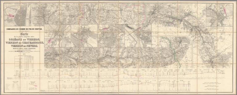
Author
Mourlhon
Full Title
Compagnie du chemin de fer du Centre. Carte de la partie comprise entre Orléans et Vierzon. Vierzon et Châteauroux, Vierzon et Nevers
List No
15871.002
Note
Scale of city plans is 1:10,000
Author
Andriveau-Goujon, E. (Eugène), 1832-1897
Full Title
Navigation à vapeur dans le bassin de Méditerranée et chemins de der de 'Europe centrale. Publiée par E. Andriveau-Goujon, Rue du Bac, 21. Paris, 1860, Impie. de Louis Antoine; le trait gravé par Smith; les escritures par P. Rousset.
List No
15659.002
Author
Andriveau-Goujon, E. (Eugène), 1832-1897
Full Title
Carte générale de l'Afrique d'après les derraeres découvertes. Publiée par E. Andriveau-Goujon, 21, Rue du Bac, Paris, 1860. Gravée par Smith et Gérin; les ecritures par P. Rousset.
List No
15640.002
Note
Hand-colored, engraved map of Africa, showing showing political boundaries, roads and railroads (on double plate with decorative border). Includes legend indicating colonies (English, French, Spanish, Portuguese and of the Sultan of Zanzibar), as well as 5 bar scales. "No. 20" in upper right. With 8 insets: (Iles Canaries) -- (Madère) -- (Iles du Cap Vért) -- (Ile de l'Ascension) -- (Ile Ste. Hélène) -- (Ile Mayotte) -- (Iles Nossi-Be) -- (Iles Mascareignes).
Author
Andriveau-Goujon, E. (Eugène), 1832-1897
Full Title
Suisse d'après l'État-Major Fédéral et les nouvelles cartes cantonales. Paris, 1860, E. Andriveau-Goujon, éditeur, Rue du Bac, 21 . Imp. Ch. Chardon ainé; gravé: le trait par Smith; la topographie par Gérin; les ecritures par P. Rousset; les eaux par Mme. Fontaine.
List No
15652.002
Note
Hand-colored, engraved map of Switzerland, showing showing political boundaries, roads and railroads (on double plate with decorative border). Includes legend, as well as 4 bar scales and a scale statement. "No. 10" in upper right. "Atlas universel, No. 23" in upper left. See our 14008.014 for the 1880 version of this map. Manuscript additions throughout, including a red set of grid lines.
Author
Vuillemin, Alexandre
Full Title
France Nouvelle Carte Routiere Donnant les Routes Royales et Departementales avec les distances en Kilometres, Les Chemins de Fer Termines et ceux votes par les Chambres les Canaux et les principales Rivieres navigables, les lignes de Bateaux a vapeur sur l'Ocean . . . 1850
List No
15585.000
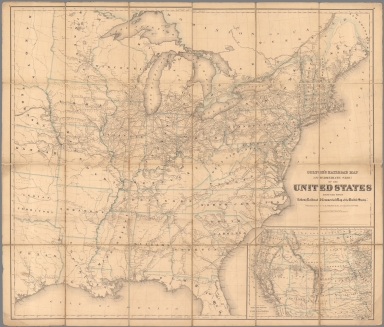
Author
Colton, G.W. & C.B.
Full Title
Colton's Railroad Map (Intermediate Size) Of The United States. Reduced Fom "Colton's Railroad & Commercial Map of the United States." Published By G.W. And C.B. Colton & Co. 172 William St. New York. Entered .. 1870 by G.W. & C.B. Colton & Co. ... New York. (inset) Plan Of The Western Portion of the United States.
List No
2689.000
Author
Knipe, James Alexander
Full Title
Geological & Mineralogical Map Of England And Wales, With Parts Of Scotland, Ireland & France, Showing also the Inland Navigation By means of Rivers & Canals, With their Elevation in feet above the Sea, The Rail Roads & Principal Roads, By J.A. Knipe ... T.W. Saunders, 6, Charing Cross) Published By J.A. Knipe, Jany. 1st 1847, and may be had of the Engraver, J. Dower, 6, Cumming Place, Pentonville, London. (Messrs. Grant & Griffith St. Pauls Ch. Yd. (late Harris). Designed and Drawn by J.A. Knipe. Engraved by I. Dower, Pentonville, London. (with 7 inset profiles).
List No
2051.002
Author
New Mexico State Corporation Commission
Full Title
Railroad Map Of The State Of New Mexico Prepared Under the Direction of State Corporation Commission 1913 ... Commissioners, Hugh H. Williams, Chairman, M.S. Groves, Commissioner, O.L. Owen, Commissioner. Santa Fe, N.M. (seal) State Corporation Commission Of New Mexico.
List No
4236.002
Author
Keeler, William J.
Full Title
National Map Of The Territory Of The United States From The Mississippi River To The Pacific Ocean. Made by the authority of the Hon. O.H. Browning Secretary of the Interior. In the Office of the Indian Bureau Chiefly For Government Purposes under the direction of the Hon. N.G. Taylor Commisr. of Indian affairs & Hon. Chas. E. Mix Chief Clerk of the Indian Bureau; Compiled from authorized explorations of Pacific Rail Road Routes, Public Surveys, and other reliable data from the Departments from the Government at Washington, D.C., by W.J. Keeler, Civil Engineer. 1867. N. DuBois Draughtsman. J.F. Gedney, Lithographer, Engraver & Plate Printer, Washington, D.C. Entered ... 1867 by Wm. J. Keeler ... District of Columbia.
List No
4737.002
Author
Keeler, William J.
Full Title
National Map Of The Territory Of The United States From The Mississippi River To The Pacific Ocean. Made by the authority of the Hon. O.H. Browning Secretary of the Interior. In the Office of the Indian Bureau Chiefly For Government Purposes under the direction of the Hon. N.G. Taylor Commisr. of Indian affairs & Hon. Chas. E. Mix Chief Clerk of the Indian Bureau; Compiled from authorized explorations of Pacific Rail Road Routes, Public Surveys, and other reliable data from the Departments from the Government at Washington, D.C., by W.J. Keeler, Civil Engineer. 1867. N. DuBois Draughtsman. J.F. Gedney, Lithographer, Engraver & Plate Printer, Washington, D.C. Entered ... 1867 by Wm. J. Keeler ... District of Columbia.
List No
0397.002
Author
Keeler, William J.
Full Title
National Map Of The Territory Of The United States From The Mississippi River To The Pacific Ocean. Made by the authority of the Hon. O.H. Browning Secretary of the Interior. In the Office of the Indian Bureau Chiefly For Government Purposes under the direction of the Hon. N.G. Taylor Commisr. of Indian affairs & Hon. Chas. E. Mix Chief Clerk of the Indian Bureau; Compiled from authorized explorations of Pacific Rail Road Routes, Public Surveys, and other reliable data from the Departments from the Government at Washington, D.C., by W.J. Keeler, Civil Engineer. 1867. N. DuBois Draughtsman. J.F. Gedney, Lithographer, Engraver & Plate Printer, Washington, D.C. Entered ... 1867 by Wm. J. Keeler ... District of Columbia.
List No
4694.002
Author
Andriveau-Goujon, J.
Full Title
Carte Generale des Routes, Des Chemins De Fer et des principales Voies Navigables De L'Europe, Redigee d'apres les Itineraires les plus recents et des Documents fournis Par Le Ministere Des Travaux Publics. (Bureau central de Statistique.) Publiee Par J. Andriveau-Goujon, Rue du Bac, 21. Paris - 1866. Paris, Impie. de Chardon Jne. fils, Rue Racine, 3. Grave par P. Rousset.
List No
1500.002
Author
Bartholomew, John
Full Title
Bartholomew's Railway Map Of The British Isles. 1927 ... The Edinburgh Geographical Institute. Copyright - John Bartholomew & Son, Ltd. (inset) London And Suburbs. (inset) Channel Islands.
List No
1543.002
Author
U.S. Coast Survey
Full Title
Southern Mississippi And Alabama Showing the Approaches To Mobile. Edw. Molitor Lith. Coast Survey Office, A.D. Bache Supt. 1863.
List No
5533.002
Author
Oklahoma Corporation Commission
Full Title
Railroad Map Of Oklahoma Published By The State. Prepared Under The Direction Of Corporation Commission Of Oklahoma 1909. Commissioners J.E. Love, Chairman, J.J. McAlester, Commissioner, A.P. Watson, Commissioner. Copyright 1909, by J.E. Love, Chairman of Corporation Commission for the State of Oklahoma. Compiled and Drawn by The Engineering Department Corporation Commission. Woodward & Tiernan Printing Co. Map Engravers, St. Louis, Mo. H.H.B. 3-1. 09. (seal) Great Seal Of The State Of Oklahoma 1907.
List No
4294.002
Author
[(Montana) Railroad Commission, Rand McNally and Company.]
Full Title
Railroad Commission Map Of Montana 1908. Commissioners: B.T. Stanton, Nathan Godfrey, E.A. Morley, H.K. Howry, Secretary. Rand, McNally & Co. Engravers, Chicago. Copyright, 1908, by Rand McNally & Co.
List No
4343.002
Author
[Geographia Map Co., Pennsylvania Railroad]
Full Title
The Complete Map of New York (Manhattan) Featuring House Numbers, Transit Lines, Playgrounds, Wading Pools, etc.
List No
15000.000
Author
Mols-Marchal, L
Full Title
Nouvelle Carte generale des Chemins de Fer de la Belgique, indiquant Les Lignes Exploites en Construction & Concedees, Ainsi Que les distances de la Capital aux differentes stations
List No
10926.002
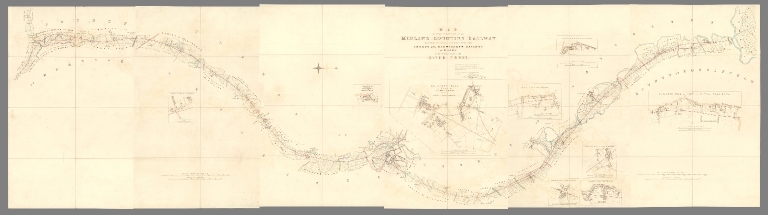
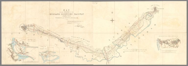
Author
[Vignoles, Charles Blacker, Midland Counties Railway Company]
Full Title
(Sheet 4) Map of that portion of the Midland Counties Railway extending from its junction with the London and Birmingham Railway at Rugby to the north side of the River Trent.
List No
10732.005
Note
Date estimated.
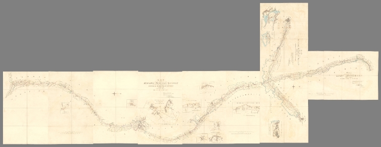
Author
[Vignoles, Charles Blacker, Midland Counties Railway Company]
Full Title
(Composite map of) (Sheets 1-6) Map of that portion of the Midland Counties Railway extending from its junction with the London and Birmingham Railway at Rugby to the north side of the River Trent.
List No
10732.008
Note
Date estimated.
Author
[Vignoles, Charles Blacker, Midland Counties Railway Company]
Full Title
(Sheet 1) Section of that Portion of the Midland Counties Railway, Extending from its junction with the London and Birmingham Railway near Rugby to the North Bank of the River Trent.
List No
10732.009
Note
Date estimated.
Author
[Vignoles, Charles Blacker, Midland Counties Railway Company]
Full Title
(Sheet 2) Section of that Portion of the Midland Counties Railway, Extending from its junction with the London and Birmingham Railway near Rugby to the North Bank of the River Trent.
List No
10732.010
Note
Date estimated.
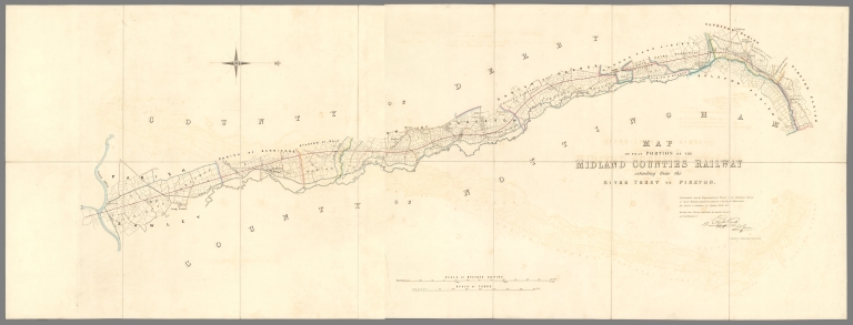
Author
[Vignoles, Charles Blacker, Midland Counties Railway Company]
Full Title
(Composite map of) (Sheets 1- 2) Map of that portion of the Midland Counties Railway extending from the River Trent to Pinxton.
List No
10732.013
Note
Date estimated.
Author
[Vignoles, Charles Blacker, Midland Counties Railway Company]
Full Title
Section of that Portion of the Midland Counties Railway, Extending from the North Bank of the River Trent to its junction with the Pinxton and Mansfield Railway at Pinxton.
List No
10732.014
Note
Date estimated.
Author
[Vignoles, Charles Blacker, Midland Counties Railway Company]
Full Title
(Composite map of) (Sheets 1- 2) Map of that portion of the Midland Counties Railway extending between Derby and Nottingham.
List No
10732.017
Note
Date estimated.
Author
[Vignoles, Charles Blacker, Midland Counties Railway Company]
Full Title
Section of that Portion of the Midland Counties Railway, Extending between Derby and Nottingham.
List No
10732.018
Note
Date estimated.
Author
[Vignoles, Charles Blacker, Midland Counties Railway Company]
Full Title
(Composite map of) All Sheets Map of that portion of the Midland Counties Railway extending from its junction with the London and Birmingham Railway at Rugby to the north side of the River Trent (River Trent to Pinxton : Derby and Nottingham) ...
List No
10732.019
Note
Date estimated.
Author
Rizzi Zannoni, Giovanni Antonio (1736-1814)
Full Title
(Title Page to) No. 2. (Fiume Tronto). Atlante geografico del regno di Napoli : compito e rettificato sotto I felici auspicj di Giuseppe Napoleone I, re di Napoli, e di Sicilia, Principe francese e grand' elettore dell' impero da Gio. Antonio Rizzi-Zannoni. Direttore del Gabinetto Topografico della M.S. Nel 1808 (1860). Gius. Guerra Inc. Nap. 1806.
List No
10572.003
Note
Vignette title page, with uncolored map. Shows provinces, cities, towns, villages, roads and rivers. Relief shown pictorially. Prime meridian is Napoli. Title of plates supplied by cataloger.
Author
Rizzi Zannoni, Giovanni Antonio (1736-1814)
Full Title
No. 14. (Napoli, Ischia, Procida, Capri, Salerno). Gius. Guerra inc. Nap. 1794. (to accompany) Atlante geografico del regno di Napoli 1808 (1860).
List No
10572.015
Note
Uncolored map. Relief shown pictorially. Prime meridian is Napoli. Title of plates supplied by cataloger.
Author
[Russian Ministry of Transport, Ilyin, A.]
Full Title
(Map of the rail, water and road routes of transport of European Russia.) Karta Zheleznykh, Vodianykh i Shosseinykh Putei Soobshcheniia Evropeiskoi Rossii.
List No
10552.000
Author
Lloyd, James T.
Full Title
NW Sheet Lloyd's American Railroad Map, Showing the Whole Seat of War.
List No
10543.001
Author
Lloyd, James T.
Full Title
NE Sheet Lloyd's American Railroad Map, Showing the Whole Seat of War.
List No
10543.002
Author
Lloyd, James T.
Full Title
SW Sheet Lloyd's American Railroad Map, Showing the Whole Seat of War.
List No
10543.003
Author
Lloyd, James T.
Full Title
SE Sheet Lloyd's American Railroad Map, Showing the Whole Seat of War.
List No
10543.004
Author
Lloyd, James T.
Full Title
(Composite map of) NW, NE, SW, SE Sheets Lloyd's American Railroad Map, Showing the Whole Seat of War
List No
10543.005
Author
[Ireland, Railway Commissioners, Griffith, Richard John,; Sir; (1784-1878)]
Full Title
(Composite map of) A General Map Of Ireland to Accompany the Report of the Railway Commissioners shewing the Principal Physical Features and Geological Structure Of The Country. Constructed In 1836 And Engraved In 1837-8. The Geology Revised And Improved In 1855. Published And Sold By Hodges & Smith, Dublin, And Longman & Co., London. With whom Copies coloured Geologically are deposited. Price Twenty Shillings Plain ...
List No
0337.006
Note
1st ed. was 1836/7; Signed by Griffith & Larcom (perhaps printed signatures). Not colored Geologically, but politically with the Railroads. Originally published to accompany the Atlas to accompany the second Report of the Railway Commissioners, 1837. Map is in four sheets, each dissected into 20 sections. Full color. Sheets have marbled end papers and fold into a black leather covered slip case 25x18 with "Map Of Ireland. Stanford" stamped in gilt on the spine.
Author
[Ireland, Railway Commissioners, Griffith, Richard John,; Sir; (1784-1878)]
Full Title
Composite map of) Sheets 1-6. A General Map Of Ireland to Accompany the Report of the Railway Commissioners shewing the Principal Physical Features and Geological Structure Of The Country. Constructed In 1836 And Engraved In 1837-8. The Geology Revised And Improved In 1855. Published And Sold By Hodges & Smith, Dublin, And Longman & Co., London. With whom Copies coloured Geologically are deposited. Price Twenty Shillings Plain ...(Geologically colored).
List No
10485.007
Note
1st ed. was 1836/7; Signed by Griffith & Larcom (perhaps printed signatures). Colored Geologically, showing political boundaries and railroads. Originally published to accompany the Atlas to accompany the second Report of the Railway Commissioners, 1837. Map is in six sheets, each dissected into 8 sections. Full color. Sheets have marbled end papers.
Author
W. & A.K. Johnston
Full Title
Johnstons' Plan of the siege of Sevastopol : showing the positions of the Allied & Russian Armies from the Admiarlty Surveys. April 1855. -- W. & A.K. Johnston. Edinburgh. Engravers & Geographer to the Queen. (to accompany) Johnstons' atlas of the war-1855. (inset) View of Sevastopol.
List No
8367.011
Note
Hand color map. Showing railways, fortified places, major cities, towns and villages, roads, churches, etc. Includes explanation and notes. Relief shown by hachures. Prime meridian is Greenwich.
Author
Rand McNally and Company
Full Title
(Composite Map of) Rand, McNally & Co.'s New Shippers' Railroad Map of the United States. Scale: 8 miles to one inch. Showing all railroads, each in a separate color, and all railroad stations in large, plain type. This is the El Paso section only, of the above named map. (Below the neatline) Rand, McNally & Co.'s New Shippers' Railroad Map of the United States, Copyright, 1888 by Rand, McNally & Co. Copyright, 1891 by Rand, McNally & Co.
List No
5802.017
Note
This is a composite of all 13 maps. The owner of the 13 maps did not include the 2 western maps in this group for some reason, roughly Dakota and Indian Territory, or they may have been lost over time. Each set of these maps was made to order custom by Rand McNally so it is possible that these 13 maps comprise the entire set. The other 2 maps of the western US to the pacific are in the set but they are at a smaller scale so they are not in this composite image.
Author
(Canada) Ministry of Public Works
Full Title
Dominion Of Canada Telegraph & Signal Service. Map No.1 (Eastern-Section). Sir Hector L. Langevin, K.C.M.G.-C.B., Minister of Public Works. F.N. Gisborne, M.I.T.E.E.-F.R.S.C., &c., Supt. T. & S. Service. 1883. Projected By F.N. Gisborne. Drawn By Gust. Smith.
List No
0118.000
Author
Canada Government Railways
Full Title
(Covers to) Map Shewing the Railways of Canada to Accompany Annual Report on Railway Statistics. 1886. Collingwood Schreiber, Chief Engineer and General Manager of Government Railways. Office Of The Chief Engineer And General Manager Of Government Railways. Compiled by E.V. Johnson, M.C.S.C.E., In charge of Draughting Offices. Drawn by A.M. Edmonds. The Burland Lithographic Co. Montreal. (seal) Department Of Railways And Canals Canada. (in red) Railways Of Canada. In Operation And Under Construction. 31st December, 1886 ...
List No
0121A
Note
Accompanies the Annual Report on Railway Statistics. With full printed color, the railways shown in red. The map is in two sheets, each dissected into 54 sections. The map sheets are folding with marbled end sheets and a brown cloth slip case 21x14 with a label reading "Canadian Dominion. London: Edward Stanford, Wholesale & Retail Mapseller, &c. 55, Charing Cross. Schreiber ..."
Author
Canada Government Railways
Full Title
Map Shewing the Railways of Canada to Accompany Annual Report on Railway Statistics. 1886. Collingwood Schreiber, Chief Engineer and General Manager of Government Railways. Office Of The Chief Engineer And General Manager Of Government Railways. Compiled by E.V. Johnson, M.C.S.C.E., In charge of Draughting Offices. Drawn by A.M. Edmonds. The Burland Lithographic Co. Montreal. (seal) Department Of Railways And Canals Canada. (in red) Railways Of Canada. In Operation And Under Construction. 31st December, 1886 ...
List No
0121.001
Note
Accompanies the Annual Report on Railway Statistics. With full printed color, the railways shown in red. The map is in two sheets, each dissected into 54 sections. The map sheets are folding with marbled end sheets and a brown cloth slip case 21x14 with a label reading "Canadian Dominion. London: Edward Stanford, Wholesale & Retail Mapseller, &c. 55, Charing Cross. Schreiber ..."
|