|
REFINE
Browse All : Railroad and Book Map of California
1-20 of 20
Author
Leahy, J.F.
Full Title
Leahy's Hotel Guide and Railway Distance Map of the State of California. Published by American Hotel Register Company. Leahy Build., 228-234 W. Ontario St., Chicago, Ill. Copyrighted by J.F. Leahy, Jan., 1934. (untitled insets of) San Francisco Bay Area, and Los Angeles and environs.
List No
0425.013
Note
Map printed without color. Includes name of the railroad entering the town, and distance between towns.
Author
Leahy, J.F.
Full Title
Leahy's Hotel Guide and Railway Distance Map of the State of California. Published by American Hotel Register Company. Leahy Build., 228-234 W. Ontario St., Chicago, Ill. Copyrighted by J.F. Leahy, Jan., 1934. (untitled insets of) San Francisco Bay Area, and Los Angeles and environs.
List No
0425.015
Note
Map printed without color. Includes name of the railroad entering the town, and distance between towns.
Author
Williamson, R.S.
Full Title
From San Francisco Bay to the Northern Boundary of California from Explorations and Surveys made under the direction of the Hon. Jefferson Davis Secretary of War by Lieut. R.S. Williamson, U.S. Topl. Engrs. and Lieut. H.L. Abbot, U.S. Topl. Engrs., H.C. Fillebrown, J. Young and C.D. Anderson, Assts. 1855. Explorations and surveys for a railroad route from the Mississippi River to the Pacific Ocean. War Department. Routes in Oregon and California. Map No. 1. Drawn by John Young.
List No
0693.024
Note
Map extends north from the tip of the San Francisco Bay to the 42nd parallel. The areas around the bay and the northern section near Lassen and Mt. Shasta are the most extensively drawn. Uncolored. List of authorities included.
Author
[Abbot, Henry L., Williamson, R.S.]
Full Title
Routes in Oregon and California. Profiles sheet no. 1 from Benicia to Fort Reading and from Fort Reading to Vancouver; from explorations and surveys made under the direction of Hon. Jefferson Davis, Sec. of War by Lieut. R.S. Williamson, U.S. Topl. Engrs. and Lieut. H.L. Abbot, U.S. Topl. Engrs, H.C. Fillerbrown, C.D. Anderson and J. Young assts. 1855. (1861)
List No
0693.026
Note
Uncolored profiles. Horizontal scale 1:15,206.4.
Author
[Abbot, Henry L., Williamson, R.S.]
Full Title
Routes in Oregon and California. Profiles sheet no. 2 from the head of Des Chutes Valley to Vancouver and from Vancouver to Fort Reading; from explorations and surveys made under the direction of Hon. Jefferson Davis, Sec. of War by Lieut. R.S. Williamson, U.S. Topl. Engrs. and Lieut. H.L. Abbot, U.S. Topl. Engrs, H.C. Fillerbrown, C.D. Anderson and J. Young assts. 1855. (1861)
List No
0693.027
Note
Uncolored profiles. Horizontal scale 1:15,206.4.
Author
Beckwith, E.G.
Full Title
From the Mud Lakes to the Pacific Ocean; from Explorations and Surveys made under the direction of the Hon. Jefferson Davis Secretary of War by Capt. E.G. Beckwith, 3d. Artillery. F.W. Egloffstein, Topographer for the Route. 1855. Explorations and surveys for a railroad route from the Mississippi River to the Pacific Ocean. War Department. Route near the 41st Parallel. Map No. 4. Selmar Siebert's Engraving & Printing Establishment. Washington, D.C.
List No
0693.031
Note
Uncolored map drawn in detail from Pyramid Lake in present-day Nevada to Mt. Shasta. The rest of the map is in sketchy detail.
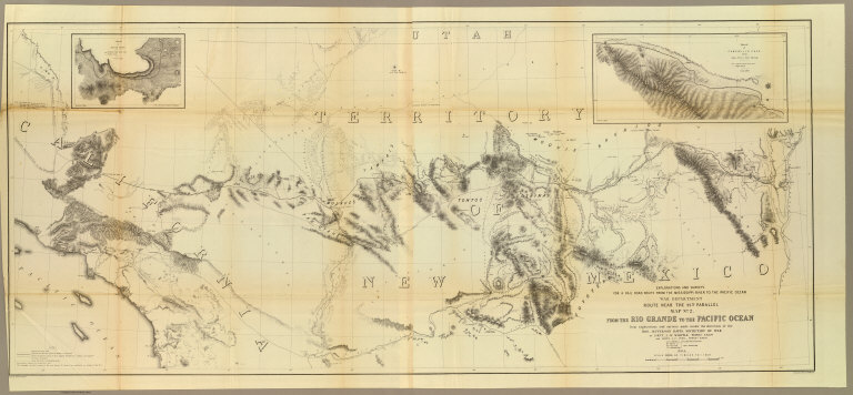
Author
[Ives, J.C., Whipple, A.W.]
Full Title
From the Rio Grande to the Pacific Ocean from explorations and surveys made under the direction of the Hon. Jefferson Davis, Secretary of War by Lieut. A.W. Whipple, Topogl. Engrs. and Lieut. J.C. Ives, Topogl. Engrs. A.H. Campbell, Civil Eng. and Surveyor, Asst. Surveyors: Wm. White Jr., N.H. Hutton, and J.P. Sherburne. 1853-4. Explorations and Surveys for a Rail Road Route from the Mississippi River to the Pacific Ocean, War Department, Route Near the 35th Parallel, Map No. 2. Engr. by Selmar Siebert. Drawn by John D. Hoffmann.
List No
0693.038
Note
The uncolored map stretches from Albuquerque in the east across the southwest to Los Angeles. With two inset maps: "Sketch of Campbell's Pass from Agua Azul to Salt Spring" and "Sketch of Aztec Pass."
Author
Williamson, R.S.
Full Title
General Map of Explorations and Surveys in California made under the direction of the Hon. Jefferson Davis, Secretary of War by Lieut. R.S. Williamson, Topogl. Engr. assisted by Lieut. J.G. Parke, Topl. Engr. and Mr. Isaac Williams Smith, Civ. Engr. 1853. Explorations and Surveys for a Rail Road Route from the Mississippi River to the Pacific Ocean. War Department. Routes in California to connect with the routes near the 32nd and 35th parallels. Engr. by Selmar Siebert.
List No
0693.040
Note
A north/south view of California from the San Francisco Bay to San Diego. The railway line is shown extending as far east as Fort Yuma. Without color.
Author
Williamson, R.S.
Full Title
Map of Passes in the Sierra Nevada from Walker's Pass to the Coast Range: from Explorations and Surveys made under the direction of the Hon. Jefferson Davis, Secretary of War by Lieut. R.S. Williamson Topl. Engr. assisted by Lieut. J.G. Parke Topl. Engr. and Mr. Isaac Williams Smith, Civ. Engr. 1853. Explorations and Surveys for a Rail Road Route from the Mississippi River to the Pacific Ocean. War Department. Routes in California to connect with the routes near the 32nd and 35th parallels. Engraved by Selmar Siebert.
List No
0693.041
Note
Map uncolored.
Author
Williamson, R.S.
Full Title
Map and Profile of the Canada de las Uvas; from Explorations and Surveys made under the direction of the Hon. Jefferson Davis, Secretary of War by Lieut. R.S. Williamson Topl. Engr. assisted by Lieut. J.G. Parke Topl. Engr. and Mr. Isaac Williams Smith, Civ. Engr. 1853. Explorations and Surveys for a Rail Road Route from the Mississippi River to the Pacific Ocean. War Department. Routes in California to connect with the routes near the 32nd and 35th parallels. Engr. by Selmar Siebert.
List No
0693.042
Note
Uncolored.
Author
Williamson, R.S.
Full Title
Map and Profile of the Tejon Pass; from Explorations and Surveys made under the direction of the Hon. Jefferson Davis, Secretary of War by Lieut. R.S. Williamson Topl. Engr. assisted by Lieut. J.G. Parke Topl. Engr. and Mr. Isaac Williams Smith, Civ. Engr. 1853. Explorations and Surveys for a Rail Road Route from the Mississippi River to the Pacific Ocean. War Department. Routes in California to connect with the routes near the 32nd and 35th parallels. Engr. by Selmar Siebert.
List No
0693.043
Note
Uncolored.
Author
Williamson, R.S.
Full Title
Sheet no. 1. Profiles of passes in the Sierra Nevada; from Explorations and Surveys made under the direction of the Hon. Jefferson Davis, Secretary of War by Lieut. R.S. Williamson, Topl. Engr. assisted by Lieut. J.G. Parke, Topl. Engr. and Mr. Isaac Williams Smith, Civ. Engr. 1853. Explorations and Surveys for a Rail Road Route from the Mississippi River to the Pacific Ocean. War Department. Routes in California to connect with the routes near the 32nd and 35th parallels. (1861)
List No
0693.044
Note
Uncolored profiles. Vertical scale 1:24,000. Contents: Profile of Walker's Pass -- Profile of Hum-pa-ya-mup Pass -- Profile of Tah-ee-chay-pah Pass -- Profile of San Fernando Pass -- Profile of route from summit of Tah-ee-chay-pah Pass to the Tejon Depot Camp -- Profile of New Pass.
Author
Williamson, R.S.
Full Title
Sheet no. 2. Profiles of passes in the Sierra Nevada; from Explorations and Surveys made under the direction of the Hon. Jefferson Davis, Secretary of War by Lieut. R.S. Williamson, Topl. Engr. assisted by Lieut. J.G. Parke, Topl. Engr. and Mr. Isaac Williams Smith, Civ. Engr. 1853. Explorations and Surveys for a Rail Road Route from the Mississippi River to the Pacific Ocean. War Department. Routes in California to connect with the routes near the 32nd and 35th parallels. (1861)
List No
0693.045
Note
Uncolored profiles. Vertical scale 1:24,000. Contents: Profile of San Francisquito Pass -- Profile of Cajon Pass -- Profile of San Gorgonio Pass -- Profile of the Colorado Desert from Station 15 of San Gorgonio Pass to the wagon road -- Profile of Warner's Pass.
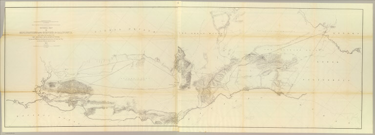
Author
Parke, John G.
Full Title
From San Francisco Bay to the Plains of Los Angeles from Explorations and Surveys made under the direction of The Hon. Jefferson Davis, Secretary of War by Lieut. John G. Parke, Topl. Engrs. assisted by Albert H. Campbell, Civil Engineer and N.H. Hutton, H. Custer and G.G. Garner. 1854 & 55. Map No. 1. Constructed and drawn by H. Custer. Explorations and Surveys for a Rail Road Route from the Mississippi River to the Pacific Ocean. War Department. Coast Route, California.
List No
0693.046
Note
Uncolored map showing the proposed rail lines along the California coastal region. Note explains that the entire coastline was derived from the U.S. Coast Survey. Other information was taken from the surveys of the U.S. General Land Office.
Author
Parke, John G.
Full Title
From the Pimas Villages to Fort Fillmore from Explorations and Surveys made under the direction of The Hon. Jefferson Davis, Secretary of War by Lieut. John G. Parke, Topl. Engrs. assisted by Albert H. Campbell, Civil Engineer and N.H. Hutton, H. Custer and G.G. Garner. 1854 & 55. Map No. 2. Engr. by Selmar Siebert. Explorations and Surveys for a Rail Road Route from the Mississippi River to the Pacific Ocean. War Department. Route near the 32nd parallel of North Latitude.
List No
0693.047
Note
Area shown is just north of the boundary line between Mexico and the United States. Uncolored. Note states that some of the information on the map was taken from Emory survey and the office of the U.S. Mexican Boundary Commission.
Author
Parke, John G.
Full Title
Profiles from San Francisco Bay to Los Angeles, Cala. and from the Pimas Villages to Fort Fillmore from Explorations and Surveys made under the direction of The Hon. Jefferson Davis, Secretary of War by Lieut. John G. Parke, Topl. Engrs., assisted by Albert H. Campbell, Civil Engineer and N.H. Hutton, H. Custer and G.G. Garner, assts. 1854 & 55. Explorations and Surveys for a Rail Road Route from the Mississippi River to the Pacific Ocean. War Department. Route near the 32d parallel & coast route, Cala.
List No
0693.048
Note
Five uncolored profiles. Contents: No. 1. Profile from the Rio Grande opposite Fort Fillmore to the Rio Gila at Maricopa Wells, Pimas Villages -- No. 2. Profile from Los Angeles to San Francisco Bay, California Coast route -- No. 3. General profile near the 32d parallel, from Fulton on Red River, Arkansas to San Diego, California, via Fort Yuma and Warner's Pass -- No. 3a. Profile from Fort Yuma on Colorado River to San Francisco Bay via San Gorgonio Pass and Los Angeles, California -- No. 4. Profile of a proposed route for a railroad between the Port of San Diego and the Gila River, California from a survey made by direction of the San Diego and Gila Railroad Company by Charles H. Poole, Chief Engineer.
Author
Atchison, Topeka and Santa Fe Railway Co.
Full Title
California via Santa Fe.
List No
12045.013
Note
Two page (four panel) spread. Oblique view to the northeast.
Author
California State Board of Trade
Full Title
Geographical, topographical and railroad map of California. Published by the California State Board of Trade, 1908. Copyrighted 1907.
List No
5644.001
Note
Col. lithographed map. Relief shown by shading and hachures. Shows railway, shipping routes and counties only. Includes comparative area map and table of agricultural statistics.
Author
Southern Pacific Company
Full Title
The Great Sunset Route. Shortest Line between the Atlantic and the Pacific Oceans... Boston Agency: 192 Washington Street 192. General Eastern Agency: New York city, 339 Broadway. (with) Map of summer & winter resorts and other places upon and near the Central & Southern Pacific railroads in California. D. Van Vleck S.F. Eng. F.T. Newbery Del. (with catalog) A List of Government And Railroad Lands in California, Open to Preemption or Homestead or to Purchase. Southern Pacific Company, New Orleans to San Francisco Via the Sunset Route. With Complements of the New York General Agency. 339 Broadway. L.H. Nutting, Eastern passenger Agent. E. Hawley, Genl. Eastern Agent.
List No
6918.002
Note
96 page list of government and railroad lands indexed by parts and sections, with 2 maps inside front and back cover, bound into orange card board cover 23x15. Maps showing the railroad lines between the Atlantic and the Pacific Oceans. " Southern Pacific Company, "Sunset Route" E.E. Currier, New Eng. Agt. 192 Washington Street, Boston Mass." Stamped on title page.
Author
Southern Pacific Company
Full Title
Map of summer & winter resorts and other places upon and near the Central & Southern Pacific railroads in California. D. Van Vleck S.F. Eng. F.T. Newbery Del. (with map)The Great Sunset Route. Shortest Line between the Atlantic and the Pacific Oceans... Boston Agency: 192 Washington Street 192. General Eastern Agency: New York city, 339 Broadway. (with catalog) A List of Government And Railroad Lands in California, Open to Preemption or Homestead or to Purchase. Southern Pacific Company, New Orleans to San Francisco Via the Sunset Route. With Complements of the New York General Agency. 339 Broadway. L.H. Nutting, Eastern passenger Agent. E. Hawley, Genl. Eastern Agent.
List No
6918.007
Note
96 page list of government and railroad lands indexed by parts and sections, with 2 maps inside front and back cover, bound into orange card board cover 23x15. Maps showing the railroad lines between the Atlantic and the Pacific Oceans. " Southern Pacific Company, "Sunset Route" E.E. Currier, New Eng. Agt. 192 Washington Street, Boston Mass." Stamped on title page.
1-20 of 20
|