|
REFINE
Browse All : Railroad and Atlas Map of Scotland
1-20 of 20
Author
Lizars, William Home, 1788-1859
Full Title
Scotland : With all the railways. Published by W.H. Lizars, Edinburgh. Samuel Highley, London & W. Curry junr. & Co, Dublin. (to accompany) Lizars' Edinburgh Geographical General Atlas ... 1841. (inset) Shetland Isles.
List No
0438.018
Note
1 map on 2 sheet, double page engraved hand colored in outline. Relief shown by hachures. Shows administrative boundaries, cities, roads, railroads, rivers and mountains. Prime meridian is Greenwich.
Author
Lizars, William Home, 1788-1859
Full Title
Scotland : With all the railways. Published by W.H. Lizars, Edinburgh. Samuel Highley, London & W. Curry junr. & Co, Dublin. (to accompany) Lizars' Edinburgh Geographical General Atlas ... 1841. (inset) Shetland Isles.
List No
0438.019
Note
1 map on 2 sheet, double page engraved hand colored in outline. Relief shown by hachures. Shows administrative boundaries, cities, roads, railroads, rivers and mountains. Prime meridian is Greenwich.
Author
Stanford, Edward
Full Title
A Railway Map of the British Isles. (inset) Orkney and Shetland Islands.
List No
0949.021
Note
Full color. Includes inset of the Orkney and Shetland islands.
Author
[Hauchecorne, G., Vandermaelen, Philippe, 1795-1869, Etablissement geographique de Bruxelles]
Full Title
Iles Britanniques. (to accompany) Carte generale des chemins de fer de l' Europe dressee d' apres des documents officiels, par G. Hauchecorne, Agent General de Chemins de fer. 1863. Etablissement geographique de Bruxelles, fonde par Ph. Vander Maelen. (Cover title) Schweizerische Nordostbahn.
List No
11612.002
Note
First edition railroad map of Europe. 1 map in 9 double page sheets. Full color by country. One of several large-scale railway maps produced by G. Hauchecorne, Agent General de Chemins de Fer, for the great Brussels publisher Philippe Vandermaelen. Each map includes separate title, showing railway system of each country, roads, major cities, towns, stations and distances between the larger cities. Railway routes shown in solid and broken lines. All lines represent the route and distances. Relief shown by hachures. Atlas title is from the first plate. The first map (Great Britain) includes inset of map of London and fourth plate (France, Espagne) includes inset map of Paris. Bound in black paper cover boards with label "Schweizerische Nordostbahn" pasted on front cover.
Author
[Arrowsmith, John, 1790-1873, Stanford, Edward, 1827-1904]
Full Title
Scotland. By John Arrowsmith London: Edward Stanford, 55 Charing Cross, S.W. Sept. 1884. (to accompany) Stanford's London Atlas Of Universal Geography. Folio edition. (inset cross-section) Section of the Caledonian Canal.
List No
11741.009
Note
Outline hand color folded map. Showing administrative divisions, cities, towns, roads, railroads, canals, mountains and rivers. Relief shown by hachures. Prime meridian is Greenwich.
Author
[Arrowsmith, John, 1790-1873, Stanford, Edward, 1827-1904]
Full Title
Stanford's map of Scotland. Constructed on the basis of the Ordnance Survey & Census ... London: Published by Edward Stanford, 55 Charing Cross, S.W. Sept. 1st. 1884. Stanford’s Geographical Establishment, London. (to accompany) Stanford's London Atlas Of Universal Geography. Folio edition. (inset) Shetland Islands.
List No
11741.010
Note
1 outline hand color map on 4 sheets. Showing administrative divisions, cities, towns, landmarks, roads, railroads, canals, parks, mountains and rivers. Relief shown by hachures. Prime meridian is Greenwich. Includes legend, abbreviations and notes.
Author
[Arrowsmith, John, 1790-1873, Stanford, Edward, 1827-1904]
Full Title
Stanford's map of Scotland. Constructed on the basis of the Ordnance Survey & Census ... London: Published by Edward Stanford, 55 Charing Cross, S.W. Sept. 1st. 1884. Stanford’s Geographical Establishment, London. (to accompany) Stanford's London Atlas Of Universal Geography. Folio edition. (inset) Shetland Islands.
List No
11741.011
Note
1 outline hand color map on 4 sheets. Showing administrative divisions, cities, towns, landmarks, roads, railroads, canals, parks, mountains and rivers. Relief shown by hachures. Prime meridian is Greenwich. Includes legend, abbreviations and notes.
Author
[Arrowsmith, John, 1790-1873, Stanford, Edward, 1827-1904]
Full Title
Stanford's map of Scotland. Constructed on the basis of the Ordnance Survey & Census ... London: Published by Edward Stanford, 55 Charing Cross, S.W. Sept. 1st. 1884. Stanford’s Geographical Establishment, London. (to accompany) Stanford's London Atlas Of Universal Geography. Folio edition. (inset) Shetland Islands.
List No
11741.012
Note
1 outline hand color map on 4 sheets. Showing administrative divisions, cities, towns, landmarks, roads, railroads, canals, parks, mountains and rivers. Relief shown by hachures. Prime meridian is Greenwich. Includes legend, abbreviations and notes.
Author
[Arrowsmith, John, 1790-1873, Stanford, Edward, 1827-1904]
Full Title
Stanford's map of Scotland. Constructed on the basis of the Ordnance Survey & Census ... London: Published by Edward Stanford, 55 Charing Cross, S.W. Sept. 1st. 1884. Stanford’s Geographical Establishment, London. (to accompany) Stanford's London Atlas Of Universal Geography. Folio edition. (inset) Shetland Islands.
List No
11741.013
Note
1 outline hand color map on 4 sheets. Showing administrative divisions, cities, towns, landmarks, roads, railroads, canals, parks, mountains and rivers. Relief shown by hachures. Prime meridian is Greenwich. Includes legend, abbreviations and notes.
Author
Bartholomew, J.G.
Full Title
Plate 15. Scotland Railways and Routes.
List No
12428.040
Author
[Koch, Wilhelm, Opitz, C.]
Full Title
Grossbritannien und Irland. Eisenbahn und verkehrsatlas von Europa. Section 78.
List No
13679.108
Note
Railways and traffic map of England, Ireland and Scotland. Prime meridian is Greenwich. Includes legend.
Author
[Weekly Dispatch, Weller, Edward, 1819-1884]
Full Title
Railway map of Great Britain : Showing all the railways, & railway stations, the canals, navigable rivers, & principal roads : (North east sheet) / by Edwd. Weller, F. R. G. S. ; engraved by Edwd. Weller, 34 Red Lion Square ; E. Weller Lithogr.
List No
14360.121
Note
Map of Great Britain, featuring railways and stations, canals, navigable rivers and roads (northeast sheet). Shows political boundaries, cities, railways, roads, canals, coal fields, bodies of water, drainage, coastlines, shoals and islands. Includes latitudinal and longitudinal lines, as well as a legend and bar scale given in British miles. With inset map: Continuation of Scotland. Hand-colored lithograph. Map is 65 x 46 cm, on double sheet 69 x 48 cm. Plate number handwritten in ink at lower left corner of sheet. Followed by maps entitled "(North west sheet) -- (South east sheet) -- (South west sheet)" on subsequent plates. Appears in Vol. I : British.
Author
Cram, George Franklin, 1841-1928
Full Title
Scotland.
List No
14372.325
Note
Map of Scotland. Shows political boundaries, cities, railroads, topography, bodies of water, drainage, coastlines and islands. Relief shown with hachures. Includes latitudinal and longitudinal lines, as well as a bar scale given in miles. Provides figures for square milage and population. Map indexed to indicate place names. Colored lithograph. Map is 52 x 41 cm, on double sheet 67 x 45 cm.
Author
Arrowsmith, John, 1790-1873
Full Title
Official map of railways in England and Scotland, shewing the existing lines & those in progress; from the maps prepared, by the authority of the Commissioners of Railways; (presented to both houses of parliament) and from the other documents; by John Arrowsmith. 1858. London, pubd. July 1st, 1858, by J. Arrowsmith, 10 Soho Square. (1)
List No
14506.012
Note
Map representing railway lines in England and Scotland. Map continues on next spread. Shows counties, cities, railways, bodies of water, drainage, coastlines and islands. Relief shown with hachures. Includes a legend, latitudinal and longitudinal lines, as well as a bar scale given in English miles. Hand-colored engraving. Map is 53 x 67 cm, on double sheet 56 x 68 cm.
Author
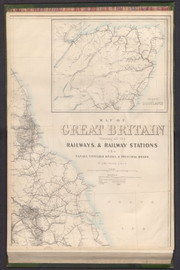
Arrowsmith, John, 1790-1873
Full Title
[Scotland.]
List No
14506.016
Note
Map representing Scotland. Shows counties, cities, railways, bodies of water, drainage, coastlines and islands. Includes latitudinal and longitudinal lines, as well as bar scales given in geographical and English miles. Hand-colored engraving. Map is 61 x 49 cm, on double sheet 68 x 56 cm.
Author
Fullarton, A. & Co.
Full Title
Railway Map of the British Isles exhibiting all the railways & canals in England, Scotland & Ireland completed or in progress with their respective stations. By J. Bartholomew Junr. Edinr. F.R.G.S. XXIV. (with) six inset maps: Enlarged Section of the South Yorkshire and Lancashire Districts; Railways Around London; Birmingham; Manchester; Edinburgh; Glasgow. Engraved by J. Bartholomew, Edinr. A. Fullarton & Co. Edinburgh, London & Dublin.
List No
3007.024
Note
In full color. Railways shown in red; railways under construction shown with dotted red lines. Lists included of references to railways in England, Scotland, and Ireland.
Author
Cram, George Franklin
Full Title
Scotland, Engraved Expressly for the Standard World Atlas. Sweden & Norway, Engraved Expressly for the Standard World Atlas.
List No
4727.101
Note
Prime meridians Washington D.C. and Greenwich. Relief shown by hachures. With printed color. Sweden and Norway map at scale 1:4,898,000.
Author
[Edward Stanford Ltd., Stanford, Edward]
Full Title
A railway map of the British Isles. London atlas series. Stanford's Geographical Establishment. London : Edward Stanford, 12, 13 & 14, Long Acre, W.C. (1901)
List No
5075.012
Note
Full color. Includes inset of the Orkney and Shetland islands.
Author
Letts, Son & Co.
Full Title
Railway & statistical map of Scotland. Letts's popular atlas. Letts, Son & Co. Limited, London. (1883)
List No
5371.025
Note
Colored map. Relief shown by hachures and spot heights. Shows counties, classified cities, railroads, shipping routes, lights and lighthouses, etc.
Author
Bevan, G. Phillips
Full Title
Scotland to Illustrate the Railway System of the Country by G. Phillips Bevan, F.S.S., F.G.S., 1881.
List No
6919.066
1-20 of 20
|


![[Scotland.]](https://www.davidrumsey.com/rumsey/Size2/RUMSEY~8~1/213/14506016.jpg)


