|
REFINE
Browse All : Railroad and Atlas Map of Nebraska
1-9 of 9
Author
Cram, George Franklin, 1841-1928
Full Title
Cram's railroad and township map of Nebraska. Published by Geo. F. Cram. 262-264 Wabash Ave. Chicago, Ills. 1882.
List No
14250.026
Note
Map of Nebraska, showing railroads, county boundaries, cities and towns, and drainage. Political boundary lines in color. Features territories of indigenous peoples, such as the Cheyenne and Sioux. Includes a bar scale and a scale statement: Scale 19 miles to an inch. With index numbers along the perimeter, and decorative border. 40 x 52 cm, on sheet 45 x 58.
Author
Cram, George Franklin, 1841-1928
Full Title
Nebraska. 1899, by Geo. F. Cram.
List No
14372.110
Note
Map of Nebraska. Shows political boundaries, counties, towns, railroads, steamship lines, topography, bodies of water, drainage, coastlines and islands. Relief shown with hachures. Includes key with explanation, latitudinal and longitudinal lines, as well as a bar scale given in miles. With alphanumeric grid corresponding to "Index of Nebraska" on pages 201-203 and 206-207. Colored lithograph. Map is 40 x 57 cm, on double sheet 45 x 67 cm. "Index of maps" and "Index of cities" in margins, providing navigation for atlas as a whole.
Author
Cram, George Franklin
Full Title
Nebraska.
List No
2809.029
Note
Locations of banking towns shown by red circles. Railroads are indicated by numbers and colors and patterns, and each railroad has the same number and color and pattern in every state through which it passes. All railroads on each map are in a list keyed to the map. Border of map has a table of contents for the atlas. Relief shown by hachures. Prime meridians Washington D.C. and Greenwich.
Author
Cram, George Franklin
Full Title
Cram's Rail Road & Township Map of Nebraska.
List No
4533.008
Author
Cram, George Franklin
Full Title
New Rail Road and County Map of Nebraska.
List No
4558.046
Author
Cram, George Franklin
Full Title
Railroad and County Map of Nebraska. Geo. F. Cram. Engraver and Publisher, Chicago.
List No
4727.028
Note
Prime meridians Washington D.C. and Greenwich. Relief shown by hachures. With printed color.
Author
Rand McNally and Company
Full Title
Commercial Atlas of America. Rand McNally Standard Map of Nebraska.
List No
5028.106
Note
Shows railroads and distances. Includes tables of principal cities and railroads, keyed to map.
Author
Rand McNally and Company
Full Title
Commercial Atlas of America. Rand McNally Black and White Mileage Map, Nebraska.
List No
5028.107
Note
Shows railroads and distances.
Author
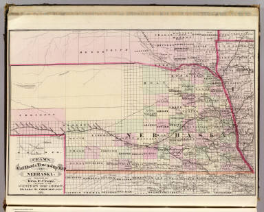
Cram, George Franklin
Full Title
Cram's Rail Road & Township Map of Nebraska. Published by Geo. F. Cram. Proprietor of the Western Map Depot. 66, Lake St. Chicago Ills. 1875.
List No
5370.018
Note
Map in full color by county. The railroad lines are clearly marked. (Note: The map has been rotated 90 degrees clockwise for readability.)
1-9 of 9
|