|
Author
Cram, George Franklin, 1841-1928
Full Title
Railroad and county map of Ohio. Geo. F. Cram, engraver and publisher, Chicago. 1882.
List No
14250.007
Note
Map of Ohio, showing railroads (both finished and unfinished), county boundaries, cities and towns, post offices, drainage and coastline. Political boundary lines in color. Includes a legend and a bar scale. With index numbers along the perimeter, and decorative border. 43 x 57 cm, on sheet 45 x 58.
Author
Cram, George Franklin, 1841-1928
Full Title
Michigan. Geo. F. Cram, engraver and publisher, 262 and 264 Wabash Avenue, Chicago, Ill. 1882.
List No
14250.011
Note
Map of Michigan, showing railroads (both finished and unfinished), county boundaries, cities and towns, drainage and coastline, as well as ports and water distances across Lake Michigan. Political boundary lines in color. Includes a legend and a bar scale. Each of the Great Lakes pictured - Michigan, Superior and Huron - lists metrics for greatest length, breadth, depth, and height above sea. With index numbers along the perimeter, and decorative border. Also, with two inset maps: Isle Royale -- Dominion of Canada. 55 x 40 cm, on sheet 58 x 45 cm.
Author
Cram, George Franklin, 1841-1928
Full Title
Indiana. Geo. F. Cram, engraver and publisher, 262 and 264 Wabash Avenue, Chicago, Ill. 1882.
List No
14250.014
Note
Map of Michigan, showing railroads (both finished and unfinished), county boundaries, cities and towns, drainage and coastline. Political boundary lines in color. With index numbers along the perimeter, and decorative border. 55 x 40 cm, on sheet 58 x 45 cm.
Author
Cram, George Franklin, 1841-1928
Full Title
Illinois. Geo. F. Cram, engraver and publisher, 262 and 264 Wabash Avenue, Chicago, Ill. 1882.
List No
14250.018
Note
Map of Illinois, showing railroads (both finished and unfinished), county boundaries, cities and towns, drainage and coastline. Political boundary lines in color. With index numbers along the perimeter, and decorative border. Also, with inset map: [Chicago and vicinity]. 55 x 40 cm, on sheet 58 x 45 cm.
Author
Cram, George Franklin, 1841-1928
Full Title
New railroad and county map of Iowa : Showing latest government surveys. Published by Geo. F. Cram, 262-264 Wabash Ave. Chicago. 1882.
List No
14250.020
Note
Map of Iowa, showing railroads (both proposed and existing), county boundaries, cities and towns, and drainage. Political boundary lines in color. Includes a legend and a bar scale. With index numbers along the perimeter, and decorative border. 37 x 50 cm, on sheet 45 x 58.
Author
Cram, George Franklin, 1841-1928
Full Title
New railroad and county map of Missouri : Showing latest government surveys. Published by Geo. F. Cram, 262-264 Wabash Ave. Chicago. 1882.
List No
14250.022
Note
Map of Missouri, showing railroads (both proposed and existing), county boundaries, cities and towns, and drainage. Political boundary lines in color. Includes a legend and a bar scale. With index numbers along the perimeter, and decorative border. Also, with two inset maps: The south-eastern extension of Missouri -- [St. Louis and vicinity]. 42 x 52 cm, on sheet 45 x 58.
Author
Cram, George Franklin, 1841-1928
Full Title
Cram's railroad and township map of Kansas. Published by Geo. F. Cram, proprietor of the Western Map Depot. 262-264 Wabash Ave. Chicago Ills. 1882.
List No
14250.024
Note
Map of Kansas, showing railroads, county boundaries, cities and towns, and drainage. Political boundary lines in color. Features territories of indigenous peoples, such as the Cheyenne, Osage and Cherokee. Includes a bar scale and a scale statement: Scale 19 miles to an inch. With index numbers along the perimeter, and decorative border. 39 x 53 cm, on sheet 45 x 58.
Author
Cram, George Franklin, 1841-1928
Full Title
Cram's railroad and township map of Nebraska. Published by Geo. F. Cram. 262-264 Wabash Ave. Chicago, Ills. 1882.
List No
14250.026
Note
Map of Nebraska, showing railroads, county boundaries, cities and towns, and drainage. Political boundary lines in color. Features territories of indigenous peoples, such as the Cheyenne and Sioux. Includes a bar scale and a scale statement: Scale 19 miles to an inch. With index numbers along the perimeter, and decorative border. 40 x 52 cm, on sheet 45 x 58.
Author
Cram, George Franklin, 1841-1928
Full Title
Cram's railroad and township map of Colorado. Published by Geo. F. Cram. 262-264 Wabash Ave. Chicago, Ills. 1882.
List No
14250.028
Note
Map of Colorado, showing railroads, county boundaries, cities and towns, and drainage. Political boundary lines in color. With index numbers along the perimeter, and decorative border. Also, with hand-drawn annotations tracing routes of travel, both along railroads and across landscapes where no official transit appears. 40 x 52 cm, on sheet 45 x 58.
Author
Cram, George Franklin, 1841-1928
Full Title
Wisconsin. Geo. F. Cram, engraver and publisher, 262 and 264 Wabash Avenue, Chicago, Ill. 1882.
List No
14250.032
Note
Map of Wisconsin, showing railroads (both finished and unfinished), county boundaries, cities and towns, post offices, drainage and coastline. Political boundary lines in color. Both of the Great Lakes pictured - Superior and Michigan - list metrics for greatest length, breadth, depth, and height above sea. Includes a legend and a bar scale. With index numbers along the perimeter, and decorative border. 55 x 40 cm, on sheet 58 x 45 cm.
Author
Cram, George Franklin, 1841-1928
Full Title
Minnesota. Geo. F. Cram, engraver and publisher, 262 and 264 Wabash Avenue, Chicago Ill.
List No
14250.034
Note
Map of Minnesota, showing railroads (both finished and unfinished), county boundaries, cities and towns, post offices, drainage and coastline. Political boundary lines in color. Features Indian reservations. Lake Superior lists metrics for greatest length, breadth, depth, and height above sea. Includes a legend and a bar scale. With index numbers along the perimeter, and decorative border. Also, with inset map: [Cook]. 55 x 40 cm, on sheet 58 x 45 cm.
Author
Cram, George Franklin, 1841-1928
Full Title
Railroad and county map of Dakota & Manitoba. Geo. F. Cram, engraver and publisher, Chicago.
List No
14250.036
Note
Map of the Dakotas and Manitoba (Canada), showing railroads (both finished and unfinished), county boundaries, cities and towns, post offices and drainage. Political boundary lines in color. Includes a legend. With index numbers along the perimeter, and decorative border. Also, with hand-drawn annotations tracing routes of travel across landscapes where no official transit appears. 55 x 40 cm, on sheet 58 x 45 cm.
Author
Cram, George Franklin, 1841-1928
Full Title
Railroad and county map of Kentucky and Tennessee. Geo. F. Cram, engraver and publisher, Chicago.
List No
14250.040
Note
Map of Kentucky and Tennessee, showing railroads (both finished and unfinished), county boundaries, cities and towns, and drainage. Political boundary lines in color. Includes a legend. With index numbers along the perimeter, and decorative border. Also, with hand-drawn annotations tracing routes of travel across landscapes where no official transit appears. 39 x 55 cm, on sheet 45 x 58 cm.
Author
Cram, George Franklin, 1841-1928
Full Title
Cram's railroad and county map of Georgia. Published by Geo. F. Cram, 262-264, Wabash, Ave. Chicago, Ills. 1882
List No
14250.042
Note
Map of Georgia, showing railroads, county boundaries, cities and towns, drainage and coastline. Political boundary lines in color. Includes a bar scale and a scale statement: Scale 19 miles to an inch. With index numbers along the perimeter, and decorative border. 47 x 37 cm, on sheet 58 x 45 cm.
Author
Cram, George Franklin, 1841-1928
Full Title
Cram's railroad and township map of Alabama. Published by Geo. F. Cram, proprietor of the Western Map Depot. 262-264, Wabash, Ave. Chicago Ills. 1882
List No
14250.044
Note
Map of Alabama, showing railroads, county boundaries, cities and towns, drainage and coastline. Political boundary lines in color. Includes a bar scale and a scale statement: Scale 19 miles to an inch. With index numbers along the perimeter, and decorative border. 51 x 31 cm, on sheet 58 x 45 cm.
Author
Cram, George Franklin, 1841-1928
Full Title
Cram's railroad and township map of Mississippi. Published by Geo. F. Cram, proprietor of the Western Map Depot. 262-264, Wabash, Ave. Chicago Ills. 1882
List No
14250.046
Note
Map of Mississippi, showing railroads, county boundaries, cities and towns, drainage and coastline. Political boundary lines in color. Includes a bar scale and a scale statement: Scale 19 miles to an inch. With index numbers along the perimeter, and decorative border. Also, with 53 x 28 cm, on sheet 58 x 45 cm.
Author
Cram, George Franklin, 1841-1928
Full Title
Cram's railroad and township map of Louisiana. Published by Geo. F. Cram, proprietor of the Western Map Depot. 262-264, Wabash, Ave. Chicago Ills. 1882
List No
14250.048
Note
Map of Louisiana, showing railroads, county boundaries, cities and towns, drainage and coastline. Political boundary lines in color. Includes a bar scale and a scale statement: Scale 18 miles to an inch. With index numbers along the perimeter, and decorative border. 51 x 42 cm, on sheet 58 x 45 cm.
Author
Cram, George Franklin, 1841-1928
Full Title
Cram's railroad and township map of Arkansas. Published by Geo. F. Cram, proprietor of the Western Map Depot. 262-264, Wabash, Ave. Chicago Ills. 1882
List No
14250.050
Note
Map of Arkansas, showing railroads, county boundaries, cities and towns, and drainage. Political boundary lines in color. Includes a bar scale and a scale statement: Scale 19 miles to an inch. With index numbers along the perimeter, and decorative border. 38 x 46 cm, on sheet 45 x 58 cm.
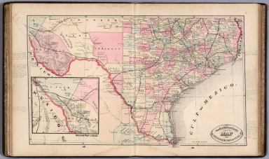
Author
Cram, George Franklin, 1841-1928
Full Title
Railroad and county map of Texas. Geo. F. Cram, engraver and publisher, Chicago.
List No
14250.053
Note
Map of Texas, showing railroads (both finished and unfinished), county boundaries, cities and towns, post offices, drainage and coastline. Political boundary lines in color. Includes a legend and a bar scale. With index numbers along the perimeter, and decorative border. Also, with an inset map: [Northern Texas]. 41 x 55 cm, on sheet 45 x 58 cm.
Author
Cram, George Franklin, 1841-1928
Full Title
Cram's railroad and township map of Indian, Ter. Published by Geo. F. Cram, proprietor of the Western Map Depot. 262-264. Wabash, Ave. Chicago Ills. 1882
List No
14250.054
Note
Map of Indian Territory, showing railroads, county boundaries, cities and towns, post offices, and drainage. Political boundary lines in color. Features territories of indigenous peoples, such as the Kiowa, Comanche, Chickasaw, Choctaw and Apache. With index numbers along the perimeter, and decorative border. 35 x 50 cm, on sheet 45 x 58 cm.
Author
[Ministere des Travaux Publics, Cheysson, Émile]
Full Title
Carte Formative du Tonnage des Chemins de Fer Francais en 1880. (Tonnage of the French railroads in 1880.)
List No
12513.010
Author
[Ministere des Travaux Publics, Cheysson, Émile]
Full Title
Carte Figurative des Expeditions de Voyageurs et de Marchandises Effectuees en 1880. (Expeditions of Travelers and Goods Made in 1880.)
List No
12513.014
Author
[Ministere des Travaux Publics, Cheysson, Émile]
Full Title
Mouvement Martime des Principaux Ports de L'Algerie et Tonnage de ses Chemins de Fer en 1880. (Main Ports of Algeria and Tonnage of its Railways in 1880.)
List No
12513.018
Author
[Ministere des Travaux Publics, Cheysson, Émile]
Full Title
Carte Figurative des Benefices Nets Kilometriques des Chemins de Fer Francais en 1880. (Net Kilometric Benefits of the French Railways in 1880.)
List No
12513.026
Author
[Ministere des Travaux Publics, Cheysson, Émile]
Full Title
Carte Figurative des Recettes des Stations des Chemins de Fer Francais en 1880. (Revenue from the Stations of the French Railways in 1880.)
List No
12513.027
Author
Blackie, W.G.
Full Title
Central Europe Showing the Principal Railways and the Political Boundaries at the Close of the Franco-German War.
List No
1589.032
Author
Cram, George Franklin
Full Title
New Rail Road and County Map of New York.
List No
4558.026
Author
Cram, George Franklin
Full Title
New Rail Road and County Map of Pennsylvania, New Jersey, Delaware & Maryland.
List No
4558.027
Author
Cram, George Franklin
Full Title
New Rail Road and County Map of Virginia & West Virginia.E
List No
4558.028
Author
Cram, George Franklin
Full Title
New Rail Road and County Map of North Carolina.
List No
4558.029
Author
Cram, George Franklin
Full Title
New Rail Road and County Map of Arkansas, Louisiana, & Mississippi.
List No
4558.034
Author
Cram, George Franklin
Full Title
New Rail Road and County Map of Indian Territory and Northern Part of Texas.
List No
4558.036
Author
Cram, George Franklin
Full Title
New Rail Road and County Map of Southern Part of Texas.
List No
4558.037
Author
Cram, George Franklin
Full Title
New Rail Road and County Map of Kentucky & Tennessee.
List No
4558.038
Author
Cram, George Franklin
Full Title
New Rail Road and County Map of Michigan & Wisconsin.
List No
4558.041
Author
Cram, George Franklin
Full Title
New Rail Road and County Map of Missouri.
List No
4558.044
Author
Cram, George Franklin
Full Title
New Rail Road and County Map of Kansas.
List No
4558.045
Author
Cram, George Franklin
Full Title
New Rail Road and County Map of Nebraska.
List No
4558.046
Author
Cram, George Franklin
Full Title
New Rail Road and County Map of Colorado.
List No
4558.047
Author
Cram, George Franklin
Full Title
New Rail Road and County Map of Minnesota.
List No
4558.048
Author
Cram, George Franklin
Full Title
New Rail Road and County Map of Dakota and Manitoba.
List No
4558.049
Author
Cram, George Franklin
Full Title
New Rail Road and County Map of Wyoming.
List No
4558.050
Author
Cram, George Franklin
Full Title
New Rail Road and County Map of Montana and Northern Idaho.
List No
4558.051
Author
Cram, George Franklin
Full Title
New Rail Road and County Map of Utah.
List No
4558.052
Author
Cram, George Franklin
Full Title
New Rail Road and County Map of Southern Part of Idaho.
List No
4558.053
Author
Cram, George Franklin
Full Title
New Rail Road and County Map of Oregon and Washington Territory.
List No
4558.054
Author
Cram, George Franklin
Full Title
New Rail Road and County Map of New Mexico.
List No
4558.055
Author
Cram, George Franklin
Full Title
New Rail Road and County Map of Northern California and Nevada.
List No
4558.056
Author
Cram, George Franklin
Full Title
New Rail Road and County Map of Southern California and Arizona.
List No
4558.058
Author
Edwards, John P.
Full Title
Edwards' Township, Railway and Postal Map of Kansas Published by Jno. P. Edwards, No. 31 5th, 6th St. Philadelphia.
List No
4836.042
|