|
Author
Survey of India Department
Full Title
Railways, telegraphs, and steamship routes. Reg. No. 191, R. & A. Dept. - Aug. 94 - 2,016. Photo., S. I. O., Calcutta.
List No
14252.042
Note
Photolithographed transportation map of India, illustrating railways, telegraphs and steamship routes. Map shows national and international transportation networks, as well as cities, bays, seas, islands, and the boundaries of adjacent countries. Indexed to indicate railway names of canals, such as Bengal Central and Mu Valley, with index in margins. Includes a legend and explanatory note. 26 x 31 cm, on sheet 34 x 43 cm.
Author
Vsesoi︠u︡znyĭ nauchno-izdatelʹskiĭ institut izobrazitelʹnoĭ statistiki (Soviet Union)
Full Title
PAЗMEЩEHИE ЖEЛEЗHOДOPOЖHOГO TPAHCПOPTA (1931) ГOД) : Tpубa (Ъaзap нa Tpубнoй илoщaби).
List No
14399.011
Note
Map representing Moscow, Russia, featuring the location of railway transport, including train stations, in 1931. Shows city limits, roads, bodies of water and drainage. Colored lithograph. Map is 33 x 33 cm, on sheet 34 x 34 cm. With an overlaid black and white photograph showing details of Moscow - the first page in a booklet that appears before the map. With descriptive text on facing page, printed in red.
Author
Vsesoi︠u︡znyĭ nauchno-izdatelʹskiĭ institut izobrazitelʹnoĭ statistiki (Soviet Union)
Full Title
PAЗMEЩEHИE ЖEЛEЗHOДOPOЖHOГO TPAHCПOPTA (1931) ГOД) : Узкии мpoмуap (мapoceйкa) -- Зacмpoйкa в кимaй-ьopoбe (ЗapябЪe) -- Cpeмeнкa.
List No
14399.012
Note
Map representing Moscow, Russia, featuring the location of railway transport, including train stations, in 1931. Shows city limits, roads, bodies of water and drainage. Colored lithograph. Map is 33 x 33 cm, on sheet 34 x 34 cm. With two overlaid black and white photographs showing details of Moscow - the second and third pages in a booklet that appears before the map. With descriptive text, printed in red.
Author
Vsesoi︠u︡znyĭ nauchno-izdatelʹskiĭ institut izobrazitelʹnoĭ statistiki (Soviet Union)
Full Title
PAЗMEЩEHИE ЖEЛEЗHOДOPOЖHOГO TPAHCПOPTA (1931) ГOД) : Бывш. мяcницкиe вopoмa -- Чacмь плaнa юp. мocвы.
List No
14399.013
Note
Map representing Moscow, Russia, featuring the location of railway transport, including train stations, in 1931. Shows city limits, roads, bodies of water and drainage. Colored lithograph. Map is 33 x 33 cm, on sheet 34 x 34 cm. With an overlaid black and white photograph and colored map showing details of Moscow - the fourth and fifth pages in a booklet that appears before the map. With descriptive text, printed in red.
Author
Vsesoi︠u︡znyĭ nauchno-izdatelʹskiĭ institut izobrazitelʹnoĭ statistiki (Soviet Union)
Full Title
PAЗMEЩEHИE ЖEЛEЗHOДOPOЖHOГO TPAHCПOPTA (1931) ГOД) : KAПИTAЛИCTИЧECKAЯ MOCKBA - ДEPEBЯHHЫЙ ГOPOД (1912 ГOД) -- KAПИTAЛИCTИЧECKAЯ MOCKBA - ГOPOД ДOMOB-KAPЛИKOB (1912 ГOД).
List No
14399.014
Note
Map representing Moscow, Russia, featuring the location of railway transport, including train stations, in 1931. Shows city limits, roads, bodies of water and drainage. Colored lithograph. Map is 33 x 33 cm, on sheet 34 x 34 cm. With two overlaid, colored illustrations showing details of Moscow - the sixth and seventh pages in a booklet that appears before the map. With descriptive text, printed in red.
Author
Vsesoi︠u︡znyĭ nauchno-izdatelʹskiĭ institut izobrazitelʹnoĭ statistiki (Soviet Union)
Full Title
PAЗMEЩEHИE ЖEЛEЗHOДOPOЖHOГO TPAHCПOPTA (1931) ГOД) : Opликoв иepeyлoк бo иocмpoйки Дoмa книъи и бoмa Hapкoмзeмa.
List No
14399.015
Note
Map representing Moscow, Russia, featuring the location of railway transport, including train stations, in 1931. Shows city limits, roads, bodies of water and drainage. Colored lithograph. Map is 33 x 33 cm, on sheet 34 x 34 cm. With descriptive text and an overlaid black and white photograph showing details of Moscow - the eighth and ninth pages in a booklet that appears before the map. With descriptive text, printed in red.
Author
Vsesoi︠u︡znyĭ nauchno-izdatelʹskiĭ institut izobrazitelʹnoĭ statistiki (Soviet Union)
Full Title
PAЗMEЩEHИE ЖEЛEЗHOДOPOЖHOГO TPAHCПOPTA (1931) ГOД) : Зacмpoйa в кoлъцe "A" иo Heьлиннoй yл -- Зacмpoйa y Poьoнccкoй зacмaьы.
List No
14399.016
Note
Map representing Moscow, Russia, featuring the location of railway transport, including train stations, in 1931. Shows city limits, roads, bodies of water and drainage. Colored lithograph. Map is 33 x 33 cm, on sheet 34 x 34 cm. With two overlaid black and white photographs showing details of Moscow - the tenth and eleventh pages in a booklet that appears before the map. With descriptive text, printed in red.
Author
Vsesoi︠u︡znyĭ nauchno-izdatelʹskiĭ institut izobrazitelʹnoĭ statistiki (Soviet Union)
Full Title
PAЗMEЩEHИE ЖEЛEЗHOДOPOЖHOГO TPAHCПOPTA (1931) ГOД).
List No
14399.017
Note
Map representing Moscow, Russia, featuring the location of railway transport, including train stations, in 1931. Shows city limits, roads, bodies of water and drainage. Colored lithograph. Map is 33 x 33 cm, on sheet 34 x 34 cm. With an overlaid black and white photograph showing details of Moscow - the twelfth page in a booklet that appears before the map. With descriptive text, printed in red.
Author
[Ministerstvo putey soobshcheniya USSR, Anatol'yev L.N.]
Full Title
Skhema Zheleznykh Dorog SSSR. (to accompany) SSSR. Ministerstvo putey Soobshcheniya Glavtransproekt. Al'bom skhem Zheleznykh Dorog SSSR. Moskva 1952 g.
List No
13556004
Note
Folded map of railways system of the Soviet Union, with 4 insets. Zak. S-42 Srt.
Author
[Ministerstvo putey soobshcheniya USSR, Anatol'yev L.N.]
Full Title
Azerbaidzhanskaia. (to accompany) SSSR. Ministerstvo putey Soobshcheniya Glavtransproekt. Al'bom skhem Zheleznykh Dorog SSSR. Moskva 1952 g.
List No
13556005
Note
Railway system map of Azerbaijan. Includes description of the names of stations and the corresponding distances.
Author
[Ministerstvo putey soobshcheniya USSR, Anatol'yev L.N.]
Full Title
Amurskaya. (to accompany) SSSR. Ministerstvo putey Soobshcheniya Glavtransproekt. Al'bom skhem Zheleznykh Dorog SSSR. Moskva 1952 g.
List No
13556006
Note
Railway system map of Amur region (also known as Amurskaya) region. Includes description of the names of stations and the corresponding distances.
Author
[Ministerstvo putey soobshcheniya USSR, Anatol'yev L.N.]
Full Title
Ashkhabadskaya. (to accompany) SSSR. Ministerstvo putey Soobshcheniya Glavtransproekt. Al'bom skhem Zheleznykh Dorog SSSR. Moskva 1952 g.
List No
13556007
Note
Railway system map of Ashgabat, now capital of Turkmenistan. Includes description of the names of stations and the corresponding distances.
Author
[Ministerstvo putey soobshcheniya USSR, Anatol'yev L.N.]
Full Title
Belorusskaya. (to accompany) SSSR. Ministerstvo putey Soobshcheniya Glavtransproekt. Al'bom skhem Zheleznykh Dorog SSSR. Moskva 1952 g.
List No
13556008
Note
Railway map of Belorusskaya stations. Includes description of the names of stations and the corresponding distances.
Author
[Ministerstvo putey soobshcheniya USSR, Anatol'yev L.N.]
Full Title
Vinnitskaya. (to accompany) SSSR. Ministerstvo putey Soobshcheniya Glavtransproekt. Al'bom skhem Zheleznykh Dorog SSSR. Moskva 1952 g.
List No
13556009
Note
Railway system map of Vinnytsia region, Ukraine. Includes description of the names of stations and the corresponding distances.
Author
[Ministerstvo putey soobshcheniya USSR, Anatol'yev L.N.]
Full Title
Vost-Sibirskaya. (to accompany) SSSR. Ministerstvo putey Soobshcheniya Glavtransproekt. Al'bom skhem Zheleznykh Dorog SSSR. Moskva 1952 g.
List No
13556010
Note
Map of Siberian Railway system. Includes description of the names of stations and the corresponding distances.
Author
[Ministerstvo putey soobshcheniya USSR, Anatol'yev L.N.]
Full Title
Gorkovskaya. (to accompany) SSSR. Ministerstvo putey Soobshcheniya Glavtransproekt. Al'bom skhem Zheleznykh Dorog SSSR. Moskva 1952 g.
List No
13556011
Note
Map of Gorkovskaya (Gorki) Railway, St. Petersburg. Includes description of the names of stations and the corresponding distances. Includes inset.
Author
[Ministerstvo putey soobshcheniya USSR, Anatol'yev L.N.]
Full Title
Dal'nevostochnaya. (to accompany) SSSR. Ministerstvo putey Soobshcheniya Glavtransproekt. Al'bom skhem Zheleznykh Dorog SSSR. Moskva 1952 g.
List No
13556012
Note
Map of railway system of Far Eastern Republic. Includes description of the names of stations and the corresponding distances.
Author
[Ministerstvo putey soobshcheniya USSR, Anatol'yev L.N.]
Full Title
Zabaykal'skaya. (to accompany) SSSR. Ministerstvo putey Soobshcheniya Glavtransproekt. Al'bom skhem Zheleznykh Dorog SSSR. Moskva 1952 g.
List No
13556013
Note
Map of Zabaykal'sk Railway. Includes description of the names of stations and the corresponding distances.
Author
[Ministerstvo putey soobshcheniya USSR, Anatol'yev L.N.]
Full Title
Zakavkazskaya. (to accompany) SSSR. Ministerstvo putey Soobshcheniya Glavtransproekt. Al'bom skhem Zheleznykh Dorog SSSR. Moskva 1952 g.
List No
13556014
Note
Map of railway system of Transcaucasian. Includes description of the names of stations and the corresponding distances.
Author
Radó, Sándor, 1899-1981
Full Title
Aufteilung der Österreichisch-Ungarischen Monarchie (Friedensverträge von St. Germain und Trianon).
List No
14253.022
Note
Political map of Eastern Europe, in black and white, showing the international boundaries established by the peace treaties of St. Germain [1919] and Trianon [1920]. Also shows the Hamburg-Bagdad railway. Includes a legend and a bar scale. Title in right margin; translates to: Division of the Austro-Hungarian Monarchy (Peace Treaties of St. Germain and Trianon). 16 x 22 cm, on sheet 26 x 34 cm. Accompanied by descriptive text on facing page.
Author
Cram, George Franklin, 1841-1928
Full Title
Michigan. 1899, by Geo. F. Cram.
List No
14372.076
Note
Map of Michigan. Shows political boundaries, counties, towns, railroads, steamship lines, topography, bodies of water, drainage, coastlines and islands. Relief shown with hachures. Includes key with explanation, latitudinal and longitudinal lines, as well as a bar scale given in miles. Two inset maps: Lake Superior -- L. Superior. With alphanumeric grid corresponding to "Index of Michigan" on pages 129-137 and 140. Colored lithograph. Map is 55 x 40 cm, on double sheet 67 x 45 cm. "Index of maps" and "Index of cities" in margins, providing navigation for atlas as a whole.
Author
Cram, George Franklin, 1841-1928
Full Title
Colorado. 1899, by Geo. F. Cram.
List No
14372.114
Note
Map of Colorado. Shows political boundaries, counties, towns, railroads, topography, bodies of water, drainage, coastlines and islands. Relief shown with hachures. Includes key with explanation, latitudinal and longitudinal lines, as well as a bar scale given in miles. With alphanumeric grid corresponding to "Index of Colorado" on pages 208-211 and 214-215. Colored lithograph. Map is 40 x 55 cm, on double sheet 45 x 67 cm. "Index of maps" and "Index of cities" in margins, providing navigation for atlas as a whole.
Author
Cram, George Franklin, 1841-1928
Full Title
Minnesota. 1899, by Geo. F. Cram.
List No
14372.124
Note
Map of Minnesota. Shows political boundaries, counties, towns, railroads, steamship lines, topography, bodies of water, drainage, coastlines and islands. Relief shown with hachures. Includes key with explanation, latitudinal and longitudinal lines, as well as a bar scale given in miles. Inset map: St. Paul and Minneapolis. With alphanumeric grid corresponding to "Index of Minnesota" on pages 226-231 and 234. Colored lithograph. Map, divided into two parts, is 55 x 40 cm, on double sheet 67 x 45 cm. "Index of maps" and "Index of cities" in margins, providing navigation for atlas as a whole.
Author
Cram, George Franklin, 1841-1928
Full Title
Oklahoma and Indianters. 1899, by Geo. F. Cram.
List No
14372.193
Note
Map of Oklahoma and Indiana. Shows political boundaries, counties, towns, railroads, topography, bodies of water, drainage, coastlines and islands. Relief shown with hachures. Includes key with explanation, latitudinal and longitudinal lines, as well as a bar scale given in miles. With alphanumeric grid corresponding to "Index of Indian Territory" on pages 357-358; "Index of Oklahoma Territory" on pages 359 and 362. Colored lithograph. Map, divided into two parts, is 40 x 57 cm, on double sheet 45 x 67 cm. "Index of maps" and "Index of cities" in margins, providing navigation for atlas as a whole.
Author
Cram, George Franklin, 1841-1928
Full Title
San Francisco.
List No
14372.198
Note
Map of San Francisco, California. Shows railroads, streets, parks, hills, bodies of water, drainage, coastlines and islands. Includes key with explanation. With alphanumeric grid corresponding to "Reference to figures" at top. Colored lithograph. Map is 28 x 28 cm, on sheet 45 x 33 cm.
Author
Cram, George Franklin, 1841-1928
Full Title
Nevada. 1899, by Geo. F. Cram.
List No
14372.200
Note
Map of Nevada. Shows political boundaries, counties, towns, railroads, topography, bodies of water, drainage, coastlines and islands. Relief shown with hachures. Includes key with explanation, latitudinal and longitudinal lines, as well as a bar scale given in miles. With alphanumeric grid corresponding to "Index of Nevada" on page 371. Colored lithograph. Map is 55 x 39 cm, on double sheet 67 x 45 cm. "Index of maps" and "Index of cities" in margins, providing navigation for atlas as a whole.
Author
Cram, George Franklin, 1841-1928
Full Title
Montana. 1899, by Geo. F. Cram.
List No
14372.211
Note
Map of Montana. Shows political boundaries, counties, towns, railroads, topography, bodies of water, drainage, coastlines and islands. Relief shown with hachures. Includes key with explanation, latitudinal and longitudinal lines, as well as a bar scale given in miles. With alphanumeric grid corresponding to "Index of Montana" on pages 387 and 390. Colored lithograph. Map is 40 x 56 cm, on double sheet 45 x 67 cm. "Index of maps" and "Index of cities" in margins, providing navigation for atlas as a whole.
Author
Cram, George Franklin, 1841-1928
Full Title
(Index Page to) Index to state map of Wyoming. (2) -- Yellowstone National Park, Wyoming. 1899, by Geo. F. Cram.
List No
14372.216
Note
Index to the map of Wyoming on preceding pages, 396-397. Lists railroads, counties and towns (including population) in alphabetical order, with associated alphanumeric coordinate points from grid on map. Includes explanation. Index on pages 395 and 398. Also, map of Yellowstone National Park, Wyoming. Shows political boundaries, topography, plateaus, canyons, basins, bodies of water, hot springs, geysers, drainage, shorelines and islands. Relief shown with hachures. Includes latitudinal and longitudinal lines, as well as a bar scale given in miles. With alphanumeric grid corresponding to "Index of Wyoming" above map and preceding on page 395. Colored lithograph. Map is 26 x 23 cm, on sheet 45 x 33 cm.
Author
Cram, George Franklin, 1841-1928
Full Title
Boston.
List No
14372.227
Note
Map of Boston, Massachusetts. Shows political boundaries, railroads, streets, parks, bodies of water, drainage, shoreline and islands. Includes a bar scale given in miles and compass rose with north oriented toward upper left. Map indexed to indicate businesses, churches and theaters, etc. Colored lithograph. Map is 31 x 24 cm, on sheet 45 x 33 cm.
Author
Cram, George Franklin, 1841-1928
Full Title
Alaska. 1899, by Geo. F. Cram.
List No
14372.238
Note
Map of Alaska. Shows political boundaries, districts, towns, railroads, topography, glaciers, bodies of water, drainage, coastlines and islands. Relief shown with hachures. Includes key with explanation, latitudinal and longitudinal lines, as well as a bar scale given in miles. Three inset maps: Cook Inlet -- Yukon River -- Klondike District. With alphanumeric grid corresponding to "Index of Alaska" on page 427. Colored lithograph. Map is 40 x 56 cm, on double sheet 45 x 67 cm. "Index of maps" and "Index of cities" in margins, providing navigation for atlas as a whole.
Author
Cram, George Franklin, 1841-1928
Full Title
Richmond and Manchester, Virginia.
List No
14372.262
Note
Map of Richmond and Manchester, Virginia. Shows political boundaries, railroads, streets, bridges, parks, bodies of water, drainage, shorelines and islands. Colored lithograph. Map is 25 x 31 cm, on sheet 33 x 45 cm.
Author
Cram, George Franklin, 1841-1928
Full Title
Map of the United States of Mexico, drawn and compiled from the latest Mexican and United States Government authorities, and other reliable sources. 1899, by Geo. F. Cram.
List No
14372.267
Note
Map of Mexico. Shows political boundaries, states, towns, railroads, topography, bodies of water, drainage, coastlines and islands. Relief shown with hachures. Includes key with explanation, latitudinal and longitudinal lines, as well as a scale statement and three bar scales given in Mexican leagues, statute miles and kilometres. With alphanumeric grid corresponding to "Index of Mexico" on pages 472-475. Colored lithograph. Map is 40 x 57 cm, on double sheet 45 x 67 cm. "Index of maps" and "Index of cities" in margins, providing navigation for atlas as a whole.
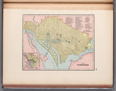
Author
Cram, George Franklin, 1841-1928
Full Title
Map of Washington.
List No
14372.272
Note
Map of Washington, D.C. Shows political boundaries, railroads, streets, bridges, parks, bodies of water, drainage, shorelines and islands. Map indexed to indicate place names, with index at upper right. Inset map: District of Columbia. Colored lithograph. Map is 22 x 29 cm, on sheet 33 x 45 cm.
Author
Cram, George Franklin, 1841-1928
Full Title
Greater New York.
List No
14372.278
Note
Map of New York City, New York, with all five boroughs and vicinity. Shows political boundaries, cities, railroads, streets, bridges, parks, bodies of water, drainage, coastlines and islands. Includes a bar scale, given in miles. Colored lithograph. Map is 27 x 34 cm, on sheet 33 x 45 cm.
Author
Cram, George Franklin, 1841-1928
Full Title
Council Bluffs.
List No
14372.287
Note
Map of Council Bluffs, Iowa. Shows political boundaries, railroads, streets, bridges, parks, bodies of water, drainage, shorelines and islands. Colored lithograph. Map is 30 x 26 cm, on sheet 45 x 33 cm.
Author
Cram, George Franklin, 1841-1928
Full Title
Map of the United States of America.
List No
14372.291
Note
Map of the United States. Shows political boundaries, cities, railroads, topography, bodies of water, drainage, shorelines and islands. Relief shown with hachures. Includes latitudinal and longitudinal lines. Inset map: Alaska. Colored lithograph. Map is 32 x 49 cm, on double sheet 45 x 67 cm.
Author
Cram, George Franklin, 1841-1928
Full Title
Denver.
List No
14372.292
Note
Map of Denver, Colorado. Shows political boundaries, railroads, streets, bridges, parks, bodies of water, drainage and shorelines. Colored lithograph. Map is 26 x 33 cm, on sheet 33 x 45 cm.
Author
Cram, George Franklin, 1841-1928
Full Title
New Orleans.
List No
14372.302
Note
Map of New Orleans, Louisiana. Shows political boundaries, railroads, streets, bridges, ferry lines, parks, topography, bodies of water and drainage. Relief shown with hachures. Includes a legend, compass rose with north oriented toward top of sheet, as well as a bar scale given in miles. Map indexed to indicate place names. Colored lithograph. Map is 28 x 24 cm, on sheet 45 x 33 cm.
Author
Cram, George Franklin, 1841-1928
Full Title
Chart of the world on Mercator's Projection.
List No
14372.316
Note
Map of the world on Mercator's Projection. Shows political boundaries, cities, railroads, topography, bodies of water, drainage, coastlines, islands and ocean currents. Relief shown with hachures. Maps include latitudinal and longitudinal lines. Provides figures for square milage and population. Six inset maps: Principal cities of the old world : London -- Paris -- Berlin -- St. Petersburg -- Vienna -- Cairo. With statistical tables on national wealth, debts and militaries in margin. Colored lithograph. Map is 38 x 44 cm, on double sheet 45 x 67 cm.
Author
Andriveau-Goujon, E. (Eugène), 1832-1897
Full Title
(2) Carte de l'Europe et du Bassin de la Méditerranée. Publiée par E. Andriveau-Goujon, 4, Rue du Bac. Paris, 1879. Paris, Impie. Alfred Chardon Jeune; gravée: la géographie par Smith; les escritures par P. Rousset; les eaux par Mm. Fontaine.
List No
14008.005
Note
Hand-colored, engraved map of Europe and the greater Mediterranean Region, showing political boundaries, roads and railroads (on double plate with decorative border). Includes legend, as well as 10 bar scales and a scale statement. Handwritten annotation in blue ink traces a route in southwestern Germany. "No. 2" in upper right.
Author
Andriveau-Goujon, E. (Eugène), 1832-1897
Full Title
(13) Empire d’Allemagne et pays limitrophes. E. Andriveau-Goujon, éditeur, Rue du Bac, 4, Paris, 1880. Gravé chez L. Wuhrer, rue de l'Abbé de l'Epée 4; Imp. Monroco, Paris.
List No
14008.017
Note
Hand-colored, engraved map of Germany, showing showing political boundaries, roads, railroads and water routes (on double plate). Includes legend, as well as a bar scale and a scale statement. Features a table: Tableau des états de l'Empire d’Allemagne. "Atlas usuel, No. 15" and "Atlas universel, No. 30" in lower left.
Author
Andriveau-Goujon, E. (Eugène), 1832-1897
Full Title
(15) Empire Ottoman et Grèce. Publié par E. Andriveau-Goujon, Rue du Bac, 4, Paris, 1879. Paris, Imp. Alfred Chardon Jne.; gravé: le trait par Smith; la topographie par Gérin; les ecritures par Rousset; les eaux par Mme. Fontaine.
List No
14008.019
Note
Hand-colored, engraved map of the Ottoman Empire and Greece, showing showing political boundaries, roads, railroads and water routes (on double plate with decorative border). Includes legend indicating ethnic divisions, as well 6 bar scales and a scale statement. Features a table: Explication de quelques dénominations géographiques. "No. 15" in upper right. "Atlas usuel, No. 21" and "Atlas universel, No. 54" in lower left.
Author
Andriveau-Goujon, E. (Eugène), 1832-1897
Full Title
(16) Carte physique & politique de l'Asie. Publiée par E. Andriveau-Goujon, 4, Rue du Bac, Paris, 1881. Gravée par Ch. Smith et Gérin; les eaux par Mme. Fontaine; Paris, Impie. Ch. Chardon, ainé, 10, r. de l'Abbaye; la lettre par Isid. Dalmont.
List No
14008.020
Note
Hand-colored, engraved map of Asia, showing showing political boundaries, roads, railroads and water routes (on double plate with decorative border). Includes legend, as well as 10 bar scales. "No. 16" in upper right. "Atlas usuel, No. 21" and "Atlas universel, No. 54" in lower left.
Author
Andriveau-Goujon, E. (Eugène), 1832-1897
Full Title
(18) Palestine ancienne & moderne d'aprés les sources les plus authentiques. Par E. Andriveau-Goujon. Paris, 1876. E. Andriveau-Goujon, éditeur. Rue du Bac, 4. Paris, imprimie. Ch. Chardon; gravé: le trait par Smith; les montagnes par Gérin; les ecritures par P. Rousset; les eaux par Mme. Fontaine.
List No
14008.022
Note
Hand-colored, engraved map of the Holy Land, showing political boundaries, roads and railroads (with decorative border). Includes legend, index, as well as 4 bar scales and a scale statement. Features translations into French. "No. 18" in upper right. "Atlas usuel, No. 23" and "Atlas universel, No. 36" in lower right. With 5 insets: (Egypt; Palestine; Arabie) -- (Golfe de Suez) -- (Niveau de la Méditerranée) -- ([Profile of mountains in vicinity of Jerusalem]) -- Jérusalem d'aprés le plan de G. Williams.
Author
Andriveau-Goujon, E. (Eugène), 1832-1897
Full Title
(19) Carte générale de l'Afrique d'après les derraeres découvertes. Publiée par E. Andriveau-Goujon, 4, Rue du Bac, Paris, 1881. Nouvelle edition. Gravée par Smith et Gérin; les ecritures par P. Rousset.
List No
14008.023
Note
Hand-colored, engraved map of Africa, showing showing political boundaries, roads and railroads (on double plate with decorative border). Includes legend indicating colonies (English, French, Spanish, Portuguese and of the Sultan of Zanzibar), as well as 5 bar scales. "No. 20" in upper right. With 8 insets: (Iles Canaries) -- (Madère) -- (Iles du Cap Vért) -- (Ile de l'Ascension) -- (Ile Ste. Hélène) -- (Ile Mayotte) -- (Iles Nossi-Be) -- (Iles Mascareignes).
Author
Andriveau-Goujon, E. (Eugène), 1832-1897
Full Title
(20) Algérie d'après les cartes de l'état-major et les documents du Ministère de la Guerre. E. Andriveau-Goujon, éditeur. Paris, Rue du Bac, 4, 1880. Paris, Impie. Alfred Chardon jeune; Gravée par Ms. Gérin; Dalmont, Smith et Fontaine.
List No
14008.024
Note
Hand-colored, engraved map of Algeria and greater North Africa, showing showing political boundaries, roads, railroads, water routes and military divisions (on double plate with decorative border). Includes legend, as well as 2 bar scales and a scale statement. "No. 21" in upper right. "Atlas usuel, No. 28" and "Atlas universel, No. 41" in lower right. With inset (indexed to show colonies): Carte d'Ensemble des rapports entre la France, l'Algérie, la Sénégambie et le Nord de l'Afrique.
Author
Andriveau-Goujon, E. (Eugène), 1832-1897
Full Title
(21) Carte de la Basse-Égypte et du Canal Maritime de Suez. Publiée par E. Andriveau-Goujon, éditeur. Rue du Bac, 21, Paris, 1880. Gravé sur pierre et chrom. par P. Méa, 14, r. des Fsés. St. Bernard; Imp. Lemercier et Cie. r. de Seine, 57, Paris.
List No
14008.025
Note
Hand-colored, engraved map of Egypt and greater North Africa, including the Suez Canal, showing showing political boundaries, roads, railroads and water routes (with decorative border). Includes legend, as well as 3 bar scales and a scale statement. "Inauguration du Canal, 17 Novembre 1869" in both upper left and right. With 3 insets: Plan d'Ismaïlia (scale 1:25,000) -- Plan de la Rade de Port Saïd et de l'embouchure du canal dans la Mediterranée (scale 1:60,000) -- Plan de la rade de Suez et de l'embouchure du canal dans la Mer Rouge (scale 1:60,000).
Author
Andriveau-Goujon, E. (Eugène), 1832-1897
Full Title
(22) Carte générale de l'Océanie. Publiée E. Andriveau-Goujon, 4, Rue du Bac, Paris, 1876. Impie. de Louis Antoine; gravé par Ch. Smith et Gérin; les eaux par Mme. Fontaine.
List No
14008.026
Note
Hand-colored, engraved map of Oceania, including the East Indies, Australia, New Zealand, and other others, showing the borders between the seas and oceans (on double plate with decorative border). Includes legend indicating European colonies (English, French, Dutch, Spanish and Portuguese). "No. 22" in upper right. With 3 insets: Iles Nouka-Hiva -- Iles Taïti -- Terres Australes.
Author
Andriveau-Goujon, E. (Eugène), 1832-1897
Full Title
(23) Amérique du Nord. Paris, 1877. E. Andriveau-Goujon, éditeur, Rue du Bac, 4. Gravé chez L. Wuhrer, R. Gay-Lussac, 52, Paris; Imp. Lemercier, Paris.
List No
14008.027
Note
Hand-colored, engraved map of North America, showing railroads, water routes with distances, ocean currents and glaciers (on double plate with decorative border). Includes legend indicating European colonies (English, French, Spanish, Danish, Swedish, Dutch, and American), as well as 4 bar scales and a scale statement. "Longitude ouest du Méridien de Paris". With inset: Iles Aléoutiennes.
Author
Andriveau-Goujon, E. (Eugène), 1832-1897
Full Title
(24) Carte générale des États-Unis et du Mexique comprenant l'Amérique centrale et les Antilles. E. Andriveau-Goujon, éditeur. Paris, Rue du Bac, 4. Nouvelle édition, 1876.
List No
14008.028
Note
Hand-colored, engraved map of the United States, Mexico, Central America and the Antilles, showing railroads and water routes (on double plate with decorative border). Includes legend indicating European colonies (French, English, Dutch, Danish, Spain and Swedish), as well as 4 bar scales. "No. 24" in upper right. With 4 insets: États de l'Amérique Centrale -- Entré de New-York -- Carte des rapports entre l'Europe & l'Amérique -- Petites Antilles et Nord de l'Amérique du Sud.
Author
Andriveau-Goujon, E. (Eugène), 1832-1897
Full Title
(25) Amérique du Sud. E. Andriveau-Goujon, éditeur, 4, Rue du Bac, Paris, 1878. Gravé chez L. Wuhrer, Rue de l'Abbé de l'Epée 4; Paris, Imp. F. Dufrenoy.
List No
14008.029
Note
Hand-colored, engraved map of South America, showing railroads, water routes with distances, ocean currents and glaciers (on double plate with decorative border). Includes legend indicating European colonies (French, English and Dutch), as well as 5 bar scales and a scale statement. "Longitude ouest du Méridien de Paris". With inset: Iles Galapagos (Dépendance de la République de l'Équateur).
Author
[IRISH RAILWAY COMMISSION, LARCOM, Thomas Aiskew (1801 - 1879)]
Full Title
I. Map of Ireland to accompany the Report of the Railway Commissioners 1838. Shewing the lines laid down Under the Direction of the Commissioners and those proposed by Private Parties. / Prepared & Engraved under the direction of Lieu.t Larcom Royal Eng.rs May 1837.
List No
15443.003
Author
[IRISH RAILWAY COMMISSION, HARNESS, Henry Drury (1804 - 1883)]
Full Title
III. Map of Ireland, to accompany the Report of the Railway Commissioners shewing the relative Quantities of Traffic in different Directions. Constructed under the Direction of the Commissioners by Henry D. Harness Lt. Royal Engineers 1837.
List No
15443.005
Author
[IRISH RAILWAY COMMISSION, HARNESS, Henry Drury (1804 - 1883)]
Full Title
IV. Map of Ireland, to accompany the Report of the Railway Commissioners shewing the relative Number of Passengers in different Directions by regular Public Conveyances. Constructed under the Direction of the Commissioners by Henry D. Harness Lt. Royal Engineers 1837.
List No
15443.006
Author
[IRISH RAILWAY COMMISSION, LARCOM, Thomas Aiskew (1801 - 1879)]
Full Title
VI. Map of England and Ireland, Explanatory of that part of the Report of the Railway Commissioners, which relates to communication between London and Dublin, and other parts of Ireland. / Prepared & Engraved under the direction of Lieu.t Larcom Royal Eng.rs May 1837.
List No
15443.008
Author
[Pershing, John J. (John Joseph), 1860-1948, Geological Survey (U.S.)]
Full Title
Map of France superimposed on that of the United States : Showing relative distances and the extent of railroad systems used by the American Expeditionary Forces. House Doc. No. 626; 66th Cong., 2d Sess. Engraved and printed by the U. S. Geological Survey.
List No
14379.023
Note
Military map of France, overlaid upon the United States in order to show the relative distances between different cities. Features the railroad systems used by the American Expeditionary Forces during World War I. Shows political boundaries, cities, drainage, coastlines and islands. Includes a legend, explanatory notes and two bar scales given in kilometers and miles, as well as a compass rose with north oriented toward top of sheet (for the United States). Colored engraving. Map is 20 x 24 cm, on fold-out sheet 23 x 27 cm.
Author
Mektepler Uqün
Full Title
جۇڭگونىك رايونلرى قاتنشى = Traffic in Chinese regions. (to accompany) جۇڭگو ئاتلسى = Jongu atlasi = Atlas of China. Ottura : Mektepler Uqün. Hormetler Neshriyâti. 1sr. edition, June 1984.
List No
13683.004
Note
Traffic map of China. With insets: airways map of China, location map and table. Showing administrative boundaries, roads, railroads and water ways.
Author
[Portugal. Ministério das Colónias, Portugal. Junta de Investigações Coloniais]
Full Title
Carta das linhas férreas e aéreas de Angola e Moçambique e suas principais ligações com as colónias limítrofes. Gravada e impressa no Instituto Geographico e Cadastral, em 1945. Ministério das Colónias, Junta das Missões Geográficas e de Investigações Coloniais, Outubro de 1940.
List No
14369.020
Note
Map of southern Africa, featuring railways and air lines of Angola and Mozambique, with their main connections to the neighboring nations. Also shows political boundaries, cities, bodies of water, drainage, coastlines and islands. Includes latitudinal and longitudinal lines, as well as a legend and bar scale. Colored lithograph. Map is 36 x 52 cm, on double sheet 48 x 69 cm.
Author
شكوفه مقبل [Şukufe Mukbil]
Full Title
(European Russia with railroads)
List No
10992.009
Note
Dimensions are sheet size.
Author
شكوفه مقبل [Şukufe Mukbil]
Full Title
(Great Britain and Ireland)
List No
10992.013
Note
Dimensions are sheet size.
Author
شكوفه مقبل [Şukufe Mukbil]
Full Title
(Italy with railroads)
List No
10992.014
Note
Dimensions are sheet size.
Author
شكوفه مقبل [Şukufe Mukbil]
Full Title
(The Caucasus with railroads)
List No
10992.021
Note
Dimensions are sheet size.
Author
[Commercial Club of Chicago. Civic Committee, Burnham, Daniel Hudson, 1846-1912, Bennett, Edward H. (Edward Herbert), 1874-1954, Moore, Charles]
Full Title
LXXIII. Chicago : Diagram of the city and surrounding country, showing railroad circuits, B, C, D and E, which are, or may become, tangent to the inner circuit (A).
List No
14346.059
Note
Map of Chicago within fifth chapter to Plan of Chicago. Shows railroads, roads, topography, lakes, drainage, shoreline and harbor. Relief shown with contour lines. With descriptive text: The diagram also shows the existing industries, and the probable trend of growth away from the center of the city. Includes a legend. Indexed, with key on facing page of descriptive text (66). Colored lithograph. Map is 21 x 17 cm, on sheet 31 x 24 cm. (Page number inferred.) Chapter spans pages 61-78.
Author
[Commercial Club of Chicago. Civic Committee, Burnham, Daniel Hudson, 1846-1912, Bennett, Edward H. (Edward Herbert), 1874-1954, Moore, Charles]
Full Title
LXXIV. Chicago : Diagram of the city center, showing the general location of existing freight yards and railroad lines, the present tunnel system and proposed circuit, and connections for all these services, running to the central clearing yards.
List No
14346.061
Note
Map of Chicago within fifth chapter to Plan of Chicago. Shows railroads, roads, shoreline and harbor. Includes a legend and bar scale. Colored lithograph. Map is 18 x 19 cm, on sheet 31 x 24 cm. (Page number inferred.) Chapter spans pages 61-78.
Author
[Commercial Club of Chicago. Civic Committee, Burnham, Daniel Hudson, 1846-1912, Bennett, Edward H. (Edward Herbert), 1874-1954, Moore, Charles]
Full Title
CXI. Chicago : Plan of the center of the city, showing the present street and boulevard system.
List No
14346.087
Note
Map of Chicago within seventh chapter to Plan of Chicago. Shows roads, railway stations, bridges, parks, drainage, shoreline and harbor. Includes a legend and bar scale. With descriptive text: The proposed additional arteries and street widenings (orange) ... Colored lithograph. Map is 22 x 18 cm, on sheet 31 x 24 cm. Chapter spans pages 99-118.
Author
[Commercial Club of Chicago. Civic Committee, Burnham, Daniel Hudson, 1846-1912, Bennett, Edward H. (Edward Herbert), 1874-1954, Moore, Charles]
Full Title
CXXIX. Chicago : The business center of the city, within the First Circuit Boulevard, showing the proposed grand east-and-west axis and its relation to Grant Park and the yacht harbor; the railway terminals schemes on the south and west sides, and the Civic Center.
List No
14346.104
Note
Map of Chicago within seventh chapter to Plan of Chicago. Shows the city's business center with proposed roads, as well as park, harbor and railway terminals. Black and white lithograph. Map is 42 x 22 cm, on double sheet 48 x 31 cm. Chapter spans pages 99-118.
Author
[Koch, Wilhelm, Opitz, C.]
Full Title
Reich, Section 1. Eisenbahn und verkehrsatlas von Europa. Section 1. Erklärungen für Deutschland. Deutsches
List No
13679.010
Note
Text and map of Germany. Includes index to the railways, lists of abbreviations, transportation, map symbols and text. Includes inset map of Helgoland Island in North Sea, Prime meridian: Greenwich.
Author
[Koch, Wilhelm, Opitz, C.]
Full Title
Deutsches Reich. Section 2. Eisenbahn und verkehrsatlas von Europa. Section 2.
List No
13679.011
Note
Railways and traffic map of Germany. Prime meridian: Greenwich. Shows boundaries and Prussian states. Includes list of private railways.
Author
[Koch, Wilhelm, Opitz, C.]
Full Title
Deutsches Reich. Section 3. Eisenbahn und verkehrsatlas von Europa. Section 3.
List No
13679.012
Note
Railways and traffic map of Germany. Prime meridian: Greenwich. Shows boundaries. Includes list of German states and private railways, Danish, and Swedish private railways.
Author
[Koch, Wilhelm, Opitz, C.]
Full Title
Deutsches Reich. Section 4. Eisenbahn und verkehrsatlas von Europa. Section 4.
List No
13679.013
Note
Railways and traffic map of Germany. Prime meridian: Greenwich. Shows boundaries and Prussian states. Includes list of states and private railways.
Author
[Koch, Wilhelm, Opitz, C.]
Full Title
Deutsches Reich. Section 5. Eisenbahn und verkehrsatlas von Europa. Section 5.
List No
13679.014
Note
Railways and traffic folded map of Germany, with inset map. Prime meridian: Greenwich. Shows boundaries and Prussian states. Includes list of states and private railways, and Russian railways.
Author
[Koch, Wilhelm, Opitz, C.]
Full Title
Deutsches Reich. Section 6. Eisenbahn und verkehrsatlas von Europa. Section 6.
List No
13679.015
Note
Railways and traffic map of Germany, with inset map. Prime meridian: Greenwich. Shows boundaries. Includes list of German states and private railways and Dutch railways.
Author
[Koch, Wilhelm, Opitz, C.]
Full Title
Deutsches Reich. Section 7. Eisenbahn und verkehrsatlas von Europa. Section 7.
List No
13679.016
Note
Railways and traffic map of Germany. Prime meridian: Greenwich. Shows boundaries. Includes list of German states and private railways.
Author
[Koch, Wilhelm, Opitz, C.]
Full Title
Deutsches Reich. Section 8. Eisenbahn und verkehrsatlas von Europa. Section 8.
List No
13679.017
Note
Railways and traffic map of Germany. Prime meridian: Greenwich. Shows boundaries. Includes list of German states and private railways.
Author
[Canet Alvarez, Gerardo A., 1911-, Raisz, Erwin, 1893-1968, Harvard University. Institute of Geographical Exploration, Cuba. Ministerio de Agricultura]
Full Title
Patron de vida.
List No
14350.019
Note
Map showing the human geography of Cuba. Title translates to: Life patterns Features roads, railways, population and water consumption in the country. Includes a bar scale. With views comparing urban and rural communities. With charts depicting the economy, tracing changes in the twentieth century. Accompanied by descriptive text, which appears in Spanish, with English translations.
Author
Cram, George Franklin, 1841-1928
Full Title
Railroad and county map of Ohio. Geo. F. Cram, engraver and publisher, Chicago. 1882.
List No
14250.007
Note
Map of Ohio, showing railroads (both finished and unfinished), county boundaries, cities and towns, post offices, drainage and coastline. Political boundary lines in color. Includes a legend and a bar scale. With index numbers along the perimeter, and decorative border. 43 x 57 cm, on sheet 45 x 58.
Author
Cram, George Franklin, 1841-1928
Full Title
Michigan. Geo. F. Cram, engraver and publisher, 262 and 264 Wabash Avenue, Chicago, Ill. 1882.
List No
14250.011
Note
Map of Michigan, showing railroads (both finished and unfinished), county boundaries, cities and towns, drainage and coastline, as well as ports and water distances across Lake Michigan. Political boundary lines in color. Includes a legend and a bar scale. Each of the Great Lakes pictured - Michigan, Superior and Huron - lists metrics for greatest length, breadth, depth, and height above sea. With index numbers along the perimeter, and decorative border. Also, with two inset maps: Isle Royale -- Dominion of Canada. 55 x 40 cm, on sheet 58 x 45 cm.
Author
Cram, George Franklin, 1841-1928
Full Title
Indiana. Geo. F. Cram, engraver and publisher, 262 and 264 Wabash Avenue, Chicago, Ill. 1882.
List No
14250.014
Note
Map of Michigan, showing railroads (both finished and unfinished), county boundaries, cities and towns, drainage and coastline. Political boundary lines in color. With index numbers along the perimeter, and decorative border. 55 x 40 cm, on sheet 58 x 45 cm.
Author
Cram, George Franklin, 1841-1928
Full Title
Illinois. Geo. F. Cram, engraver and publisher, 262 and 264 Wabash Avenue, Chicago, Ill. 1882.
List No
14250.018
Note
Map of Illinois, showing railroads (both finished and unfinished), county boundaries, cities and towns, drainage and coastline. Political boundary lines in color. With index numbers along the perimeter, and decorative border. Also, with inset map: [Chicago and vicinity]. 55 x 40 cm, on sheet 58 x 45 cm.
Author
Cram, George Franklin, 1841-1928
Full Title
New railroad and county map of Iowa : Showing latest government surveys. Published by Geo. F. Cram, 262-264 Wabash Ave. Chicago. 1882.
List No
14250.020
Note
Map of Iowa, showing railroads (both proposed and existing), county boundaries, cities and towns, and drainage. Political boundary lines in color. Includes a legend and a bar scale. With index numbers along the perimeter, and decorative border. 37 x 50 cm, on sheet 45 x 58.
Author
Cram, George Franklin, 1841-1928
Full Title
New railroad and county map of Missouri : Showing latest government surveys. Published by Geo. F. Cram, 262-264 Wabash Ave. Chicago. 1882.
List No
14250.022
Note
Map of Missouri, showing railroads (both proposed and existing), county boundaries, cities and towns, and drainage. Political boundary lines in color. Includes a legend and a bar scale. With index numbers along the perimeter, and decorative border. Also, with two inset maps: The south-eastern extension of Missouri -- [St. Louis and vicinity]. 42 x 52 cm, on sheet 45 x 58.
Author
Cram, George Franklin, 1841-1928
Full Title
Cram's railroad and township map of Kansas. Published by Geo. F. Cram, proprietor of the Western Map Depot. 262-264 Wabash Ave. Chicago Ills. 1882.
List No
14250.024
Note
Map of Kansas, showing railroads, county boundaries, cities and towns, and drainage. Political boundary lines in color. Features territories of indigenous peoples, such as the Cheyenne, Osage and Cherokee. Includes a bar scale and a scale statement: Scale 19 miles to an inch. With index numbers along the perimeter, and decorative border. 39 x 53 cm, on sheet 45 x 58.
Author
Cram, George Franklin, 1841-1928
Full Title
Cram's railroad and township map of Nebraska. Published by Geo. F. Cram. 262-264 Wabash Ave. Chicago, Ills. 1882.
List No
14250.026
Note
Map of Nebraska, showing railroads, county boundaries, cities and towns, and drainage. Political boundary lines in color. Features territories of indigenous peoples, such as the Cheyenne and Sioux. Includes a bar scale and a scale statement: Scale 19 miles to an inch. With index numbers along the perimeter, and decorative border. 40 x 52 cm, on sheet 45 x 58.
Author
Cram, George Franklin, 1841-1928
Full Title
Cram's railroad and township map of Colorado. Published by Geo. F. Cram. 262-264 Wabash Ave. Chicago, Ills. 1882.
List No
14250.028
Note
Map of Colorado, showing railroads, county boundaries, cities and towns, and drainage. Political boundary lines in color. With index numbers along the perimeter, and decorative border. Also, with hand-drawn annotations tracing routes of travel, both along railroads and across landscapes where no official transit appears. 40 x 52 cm, on sheet 45 x 58.
Author
Cram, George Franklin, 1841-1928
Full Title
Wisconsin. Geo. F. Cram, engraver and publisher, 262 and 264 Wabash Avenue, Chicago, Ill. 1882.
List No
14250.032
Note
Map of Wisconsin, showing railroads (both finished and unfinished), county boundaries, cities and towns, post offices, drainage and coastline. Political boundary lines in color. Both of the Great Lakes pictured - Superior and Michigan - list metrics for greatest length, breadth, depth, and height above sea. Includes a legend and a bar scale. With index numbers along the perimeter, and decorative border. 55 x 40 cm, on sheet 58 x 45 cm.
Author
Cram, George Franklin, 1841-1928
Full Title
Minnesota. Geo. F. Cram, engraver and publisher, 262 and 264 Wabash Avenue, Chicago Ill.
List No
14250.034
Note
Map of Minnesota, showing railroads (both finished and unfinished), county boundaries, cities and towns, post offices, drainage and coastline. Political boundary lines in color. Features Indian reservations. Lake Superior lists metrics for greatest length, breadth, depth, and height above sea. Includes a legend and a bar scale. With index numbers along the perimeter, and decorative border. Also, with inset map: [Cook]. 55 x 40 cm, on sheet 58 x 45 cm.
Author
Cram, George Franklin, 1841-1928
Full Title
Railroad and county map of Dakota & Manitoba. Geo. F. Cram, engraver and publisher, Chicago.
List No
14250.036
Note
Map of the Dakotas and Manitoba (Canada), showing railroads (both finished and unfinished), county boundaries, cities and towns, post offices and drainage. Political boundary lines in color. Includes a legend. With index numbers along the perimeter, and decorative border. Also, with hand-drawn annotations tracing routes of travel across landscapes where no official transit appears. 55 x 40 cm, on sheet 58 x 45 cm.
Author
Cram, George Franklin, 1841-1928
Full Title
Railroad and county map of Kentucky and Tennessee. Geo. F. Cram, engraver and publisher, Chicago.
List No
14250.040
Note
Map of Kentucky and Tennessee, showing railroads (both finished and unfinished), county boundaries, cities and towns, and drainage. Political boundary lines in color. Includes a legend. With index numbers along the perimeter, and decorative border. Also, with hand-drawn annotations tracing routes of travel across landscapes where no official transit appears. 39 x 55 cm, on sheet 45 x 58 cm.
Author
Cram, George Franklin, 1841-1928
Full Title
Cram's railroad and county map of Georgia. Published by Geo. F. Cram, 262-264, Wabash, Ave. Chicago, Ills. 1882
List No
14250.042
Note
Map of Georgia, showing railroads, county boundaries, cities and towns, drainage and coastline. Political boundary lines in color. Includes a bar scale and a scale statement: Scale 19 miles to an inch. With index numbers along the perimeter, and decorative border. 47 x 37 cm, on sheet 58 x 45 cm.
Author
Cram, George Franklin, 1841-1928
Full Title
Cram's railroad and township map of Alabama. Published by Geo. F. Cram, proprietor of the Western Map Depot. 262-264, Wabash, Ave. Chicago Ills. 1882
List No
14250.044
Note
Map of Alabama, showing railroads, county boundaries, cities and towns, drainage and coastline. Political boundary lines in color. Includes a bar scale and a scale statement: Scale 19 miles to an inch. With index numbers along the perimeter, and decorative border. 51 x 31 cm, on sheet 58 x 45 cm.
Author
Cram, George Franklin, 1841-1928
Full Title
Cram's railroad and township map of Mississippi. Published by Geo. F. Cram, proprietor of the Western Map Depot. 262-264, Wabash, Ave. Chicago Ills. 1882
List No
14250.046
Note
Map of Mississippi, showing railroads, county boundaries, cities and towns, drainage and coastline. Political boundary lines in color. Includes a bar scale and a scale statement: Scale 19 miles to an inch. With index numbers along the perimeter, and decorative border. Also, with 53 x 28 cm, on sheet 58 x 45 cm.
Author
Cram, George Franklin, 1841-1928
Full Title
Cram's railroad and township map of Louisiana. Published by Geo. F. Cram, proprietor of the Western Map Depot. 262-264, Wabash, Ave. Chicago Ills. 1882
List No
14250.048
Note
Map of Louisiana, showing railroads, county boundaries, cities and towns, drainage and coastline. Political boundary lines in color. Includes a bar scale and a scale statement: Scale 18 miles to an inch. With index numbers along the perimeter, and decorative border. 51 x 42 cm, on sheet 58 x 45 cm.
Author
Cram, George Franklin, 1841-1928
Full Title
Cram's railroad and township map of Arkansas. Published by Geo. F. Cram, proprietor of the Western Map Depot. 262-264, Wabash, Ave. Chicago Ills. 1882
List No
14250.050
Note
Map of Arkansas, showing railroads, county boundaries, cities and towns, and drainage. Political boundary lines in color. Includes a bar scale and a scale statement: Scale 19 miles to an inch. With index numbers along the perimeter, and decorative border. 38 x 46 cm, on sheet 45 x 58 cm.
Author
Cram, George Franklin, 1841-1928
Full Title
Railroad and county map of Texas. Geo. F. Cram, engraver and publisher, Chicago.
List No
14250.053
Note
Map of Texas, showing railroads (both finished and unfinished), county boundaries, cities and towns, post offices, drainage and coastline. Political boundary lines in color. Includes a legend and a bar scale. With index numbers along the perimeter, and decorative border. Also, with an inset map: [Northern Texas]. 41 x 55 cm, on sheet 45 x 58 cm.
Author
Cram, George Franklin, 1841-1928
Full Title
Cram's railroad and township map of Indian, Ter. Published by Geo. F. Cram, proprietor of the Western Map Depot. 262-264. Wabash, Ave. Chicago Ills. 1882
List No
14250.054
Note
Map of Indian Territory, showing railroads, county boundaries, cities and towns, post offices, and drainage. Political boundary lines in color. Features territories of indigenous peoples, such as the Kiowa, Comanche, Chickasaw, Choctaw and Apache. With index numbers along the perimeter, and decorative border. 35 x 50 cm, on sheet 45 x 58 cm.
Author
[Budapest (Hungary). Föváros Statisztikai Hivatal, Illyefalvi, Lajos I., 1881-1944]
Full Title
Vasúthálózat és a fontosabb vasútállomások személyforgalma. = Eisenbahnnetz und Personenverkehr der Wichtigeren Eisenbahnstationen.
List No
14247.118
Note
Colored map, overlaid with data visualization, representing the railway network and passenger traffic of major railway stations in Budapest and greater Hungary, in 1936. Includes legend, as well as explanatory text. In both Hungarian and German. Map is 23 x 30 cm, on sheet 26 x 35 cm.
Author
[Budapest (Hungary). Föváros Statisztikai Hivatal, Illyefalvi, Lajos I., 1881-1944]
Full Title
A vasútvonalak belföldi árufelhozatalának intenzitása. = Intensität der Inländischen Güterzufuhr auf den Eisenbahnlinien. 1933.
List No
14246.024
Note
Colored map, overlaid with data visualization, representing the density of the domestic supply of goods along the railway lines of Hungary, in 1933. Includes a legend, as well as explanatory text. In both Hungarian and German. Map is 23 x 30 cm, on sheet 26 x 35 cm.
Author
Goad, Charles E.
Full Title
101: Hunslet Lane : Midlane railway. Leeds C arriers' Warehouses : First sheet, November 1896.
List No
13564.004
Note
Insurance plans 101-A-101-E: Hunslet Lane. Showing Midland railway, with 9 inset plans.
Author
Goad, Charles E.
Full Title
102: Gotts Fields Warehouses. Wellington Road - Great Northern rail'y. Leeds Carriers' Warehouses : Second sheet, November 1896.
List No
13564.005
Note
3 insurance plans on 1 sheet. 102A-102-J: Gotts Fields Warehouses; Marsh Lane Goods warehouse; Whitehall Road Warehouse. Relief shown by hachures.
Author
Goad, Charles E.
Full Title
103: Wellington St. Warehouses. Leeds Carriers' Warehouses : Third sheet, November 1896.
List No
13564.006
Note
Insurance plans: 103A-103L: Wellington St. Warehouses. Showing railways.
Author
Goad, Charles E.
Full Title
104: Bridge End Warehouses. Leeds Carriers' Warehouses : Fourth sheet, November 1896.
List No
13564.007
Note
Insurance plans: 104A-104S: Bridge End Warehouses. Showing railways.
Author
Goad, Charles E.
Full Title
105: Wakefield. (Kirkgate) Lankshire & Yorkshire & great Northern Joint railways. Leeds Carriers' Warehouses : Fifth sheet, November 1896.
List No
13564.008
Note
Insurance plans 105 A-105W: Wakefield. (Kirkgate). Showing railways. Includes key map.
Author
Goad, Charles E.
Full Title
106: Bradford. Leeds Carriers' Warehouses : Sixth sheet, Novr. 1896.
List No
13564.009
Note
Insurance plans 106A-106G: Bradford. Showing railways. Includes key map.
Author
Goad, Charles E.
Full Title
107: Bradford : Midland Lanc. & York & L & N.W. Raily. Whses. Leeds Carriers' Warehouses : Seventh sheet, Novr. 1896.
List No
13564.010
Note
Insurance plans 107A-107G: Bradford. Showing railways.
Author
Mayer, Alexander
Full Title
(Title Page to) Post- und Eisenbahn-Karte der Osterreichisch-Ungarischen Monarchie. Herausgegeben vom Post-Cours-Boureau des K.K. Handelsministeriums In XVI. Blättern, im Maasse 1: 576,000. Entworfen vom k.k. Postrathe A. Mayer. Gezeichnet von K. K. Postloffizialen Joh. Gottwald u. Jos. Broditzky. Druck u. verlag v. R. v. Walheim in Wien.
List No
13387.003
Note
Title page and part of map of Germany.
Author
[Bertillon, Jacques, 1851-1922, Seine. Service de la statistique municipale]
Full Title
Paris 1888 : Recette kilometriques des tramways et chemin de fer de ceinture de Paris. A. Baudry del. Grave chez L. Wuhrer. Imp. Lemercier et Cie. (to accompany) Atlas de statistique graphique de la ville de Paris. I-II. Annee 1888. Paris : G. Masson,1889.
List No
13101.019
Note
Map of Paris on 2 sheets. Showing the average line length of the tramway and railway systems of Paris. Includes notes and legend.
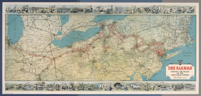
Author
[Whitney-Graham Company, Inc., Erie Railroad Company]
Full Title
Ship and travel by fast Erie Service. Erie Railroad serving the heart of industrial empire. (to accompany) The blue book of map making : America's map makers. R.W.C. The Whitney-Graham Co. Inc. (5 insets).
List No
11489.022
Note
Color map folded. Includes illustration of industry and agriculture on upper and lower panels. Map showing Erie Railroad and trackage rights over railroad in color. Also shows state boundaries, cities, towns and roads.
Author
Andreas, A. T. (Alfred Theodore), 1839-1900
Full Title
New railroad map of the United States, the Dominion of Canada, Mexico and the West Indies. (Published by the Andreas Atlas Co., Lakeside Building, Chicago, Ills. Engraved & printed by Chas. Shober & Co., Props. of Chicago Lithographing Co.)
List No
0018.012
Note
Hand col. lithographed map. Relief shown by hachures. Title includes view. Prime meridians: Washington and Greenwich.
Author
[Andreas, A. T. (Alfred Theodore), 1839-1900, Baskin, Forster and Company]
Full Title
New railroad map of the United States and Dominion of Canada. (Published by Baskin, Forster & Co. Lakeside Building Chicago, Ills. 1876. Engraved & Printed by Chas. Shober & Co. Props. of Chicago Lithographing Co.)
List No
0019.006
Note
Lithographed map. Hand col. Relief shown by hachures. Includes farm scene below title.
Author
Cram, George Franklin
Full Title
Railroad and County Map of New Jersey.
List No
0210.028
Note
Prime meridians Greenwich and Washington.
Author
Cram, George Franklin
Full Title
New Rail Road and County Map of Deleware (Delaware), Maryland, Virginia & West Virginia.
List No
0210.029
Note
Prime meridians Greenwich and Washington.
Author
Cram, George Franklin
Full Title
New Rail Road and Count Map of North Carolina.
List No
0210.030
Note
Prime meridians Greenwich and Washington.
Author
Cram, George Franklin
Full Title
New Rail Road and County Map of Alabama, Georgia, Sth. Carolina & Northern Florida.
List No
0210.031
Note
Prime meridians Greenwich and Washington.
Author
Cram, George Franklin
Full Title
New Rail Road and County Map of Kentucky & Tennessee.
List No
0210.032
Note
Prime meridians Greenwich and Washington.
Author
Cram, George Franklin
Full Title
New Rail Road and County Map of Missouri.
List No
0210.033
Note
Prime meridians Greenwich and Washington.
Author
Cram, George Franklin
Full Title
New Rail Road and County Map of Michigan & Wisconsin.
List No
0210.040
Note
Prime meridians Greenwich and Washington.
Author
[Gray, Frank A., Gray, O.W.]
Full Title
Gray's Atlas New Rail Road and County Map of the States of Oregon, California, and Nevada Compiled and Drawn by Frank A. Gray. Published by O.W. Gray, Phladelphia. (inset) Enlarged Plan of the Vicinity of San Francisco and Sacramento.
List No
0310.081
Author
Larousse
Full Title
France (Chemins de Fer).
List No
0418.081
Author
Lizars, William Home, 1788-1859
Full Title
England. Published by W.H. Lizars, Edinburgh. With all the railways. Samuel Highley, London & W. Curry junr. & Co, Dublin. (to accompany) Lizars' Edinburgh Geographical General Atlas ... 1841.
List No
0438.015
Note
1 map on 2 sheet, double page engraved hand colored in outline. Relief shown by hachures. Shows administrative boundaries, cities, roads, railroads, rivers and mountains. Prime meridian is Greenwich.
Author
Lizars, William Home, 1788-1859
Full Title
England. Published by W.H. Lizars, Edinburgh. With all the railways. Samuel Highley, London & W. Curry junr. & Co, Dublin. (to accompany) Lizars' Edinburgh Geographical General Atlas ... 1841.
List No
0438.016
Note
1 map on 2 sheet, double page engraved hand colored in outline. Relief shown by hachures. Shows administrative boundaries, cities, roads, railroads, rivers and mountains. Prime meridian is Greenwich.
Author
Lizars, William Home, 1788-1859
Full Title
Scotland : With all the railways. Published by W.H. Lizars, Edinburgh. Samuel Highley, London & W. Curry junr. & Co, Dublin. (to accompany) Lizars' Edinburgh Geographical General Atlas ... 1841. (inset) Shetland Isles.
List No
0438.018
Note
1 map on 2 sheet, double page engraved hand colored in outline. Relief shown by hachures. Shows administrative boundaries, cities, roads, railroads, rivers and mountains. Prime meridian is Greenwich.
Author
Lizars, William Home, 1788-1859
Full Title
Scotland : With all the railways. Published by W.H. Lizars, Edinburgh. Samuel Highley, London & W. Curry junr. & Co, Dublin. (to accompany) Lizars' Edinburgh Geographical General Atlas ... 1841. (inset) Shetland Isles.
List No
0438.019
Note
1 map on 2 sheet, double page engraved hand colored in outline. Relief shown by hachures. Shows administrative boundaries, cities, roads, railroads, rivers and mountains. Prime meridian is Greenwich.
Author
Lizars, William Home, 1788-1859
Full Title
Ireland : With all the railways. Published by W.H. Lizars, Edinburgh. Samuel Highley, London & W. Curry junr. & Co, Dublin. (to accompany) Lizars' Edinburgh Geographical General Atlas ... 1841.
List No
0438.021
Note
1 map on 2 sheet, double page engraved hand colored in outline. Relief shown by hachures. Shows administrative boundaries, cities, roads, railroads, rivers, canals and mountains.
Author
Lizars, William Home, 1788-1859
Full Title
Ireland : With all the railways. Published by W.H. Lizars, Edinburgh. Samuel Highley, London & W. Curry junr. & Co, Dublin. (to accompany) Lizars' Edinburgh Geographical General Atlas ... 1841.
List No
0438.022
Note
1 map on 2 sheet, double page engraved hand colored in outline. Relief shown by hachures. Shows administrative boundaries, cities, roads, railroads, rivers, canals and mountains.
Author
Lizars, William Home, 1788-1859
Full Title
France, in provinces. Published by W. Lizars, Edinburgh. (to accompany) Lizars' Edinburgh Geographical General Atlas ... 1841.
List No
0438.043
Note
Double page engraved hand colored in outline map. Color coded by provinces. Relief shown by hachures. Shows towns, roads, railroads, rivers, forests and mountains. Prime meridian is Greenwich.
Author
Lizars, William Home, 1788-1859
Full Title
France in departments. Published by W. Lizars, Edinburgh. (to accompany) Lizars' Edinburgh Geographical General Atlas ... 1841. (inset) Corsica.
List No
0438.044
Note
Double page engraved hand colored in outline map. Color coded by departments. Relief shown by hachures. Shows towns, roads, railroads, rivers, forests and mountains. Prime meridian is Greenwich. Includes note.
Author
Lizars, William Home, 1788-1859
Full Title
United States & Texas. With all the railways and canals. Published by W. Lizars, Edinburgh. (to accompany) Lizars' Edinburgh Geographical General Atlas ... 1841.
List No
0438.074
Note
Double page engraved hand colored in outline. Relief shown by hachures. Shows "Republic of Texas," the eastern United States and its western territories, Indian settlements, towns, roads, railroads, rivers, canals and mountains. Prime meridian is Greenwich.
Author
Mitchell, Samuel Augustus Jr.
Full Title
Railroad map of the United States, showing the through lines of communication from the Atlantic to the Pacific, together with the various steamship lines along the seaboard. Copyright by Wm. M. Bradley & Bro. 1884.
List No
0592.010
Note
Red printed colored lines. Relief shown by hachures. Shows settlements, rivers, named railroads and steamship lines, etc. Prime meridians: Greenwich and Washington.
Author
Mitchell, Samuel Augustus Jr.
Full Title
Map of Mexico, Central America, and the West Indies. (with) Map of the Bermuda Islands. (with) Map of the island of Jamaica. (with) Map of the proposed ship rail road route across the isthmus of Tehuantepec. (with) Map of the Panama Railroad and proposed canal. (with) Map of the proposed Nicaragua Canal route. Copyright by S. Augustus Mitchell 1884.
List No
0592.053
Note
Hand colored map with 5 insets. Relief shown by hachures. Shows states, settlements, railroads, rivers, etc. Prime meridians: Greenwich and Washington.
Full Title
Railroad map of the United States, showing the through lines of communication from the Atlantic to the Pacific, together with the various steamship lines along the seaboard. Copyright 1886 by Wm. M. Bradley & Bro. (1890)
List No
0594.009
Note
Colored map. Relief shown by hachures. Shows settlements, rivers, named railroads and steamship lines, etc. Prime meridians: Greenwich and Washington.
Full Title
Map of Mexico, Central America, and the West Indies. (with) Map of the Bermuda Islands. (with) Map of the island of Jamaica. (with) Map of the proposed ship rail road route across the isthmus of Tehuantepec. (with) Map of the Panama Railroad and proposed canal. (with) Map of the proposed Nicaragua Canal route. Copyright 1887 by Wm. M. Bradley & Bro. (1890)
List No
0594.051
Note
Hand colored map with 5 insets. Relief shown by hachures. Shows states, settlements, railroads, rivers, etc. Prime meridians: Greenwich and Washington.
Author
Society for the Diffusion of Useful Knowledge (Great Britain)
Full Title
England with its canals and railways. Published under the superintendence of the Society for the Diffusion of Useful Knowledge. London, published by Baldwin & Cradock, 47 Paternoster Row Octr. 1st. 1837. Engd. by J. & C. Walker. (London: Chapman and Hall, 1844)
List No
0890.013
Note
Engraved map. Canals, railroads and county boundaries hand col.
Author
Snyder, Van Vechten & Co.
Full Title
New rail road map of the United States. (Compiled and published by Snyder, Van Vechten & Co., Milwaukee. 1878)
List No
0936.010
Note
Hand col. lithographed map. Relief shown by hachures. Includes 2 small views.
Author
Stanford, Edward
Full Title
A Railway Map of the British Isles. (inset) Orkney and Shetland Islands.
List No
0949.021
Note
Full color. Includes inset of the Orkney and Shetland islands.
Author
J.H. Stuart & Co.
Full Title
Railroad map of Maine. (1894)
List No
0966.002
Note
Uncolored lithographed map. Shows named railroads, cities, counties, etc.
Author
[Martin, R.M., Tallis, J. & F.]
Full Title
Talis's Railway Map of Great Britain. Showing the Railways Completed, and the Stations on each line, up to the present time.
List No
10095.088
Author
[Touring club italiano, Funk & Wagnalls Company.]
Full Title
Linee di comunicazione del Oceano Atlantico. Propr. Artistico-letteraria del T.C.I. Ufficio cartografico del T.C.I. (1929)
List No
1012.003
Note
Color map.
Author
[Touring club italiano, Funk & Wagnalls Company.]
Full Title
Linee di comunicazione degli oceani Indiano e Pacifico. Propr. Artistico-letteraria del T.C.I. Ufficio cartografico del T.C.I. (1929)
List No
1012.004
Note
Color map.
Author
[Touring club italiano, Funk & Wagnalls Company.]
Full Title
Linee di comunicazione dell'Europa centrale e Mediterranea. Propr. Artistico-letteraria del T.C.I. Ufficio cartografico del T.C.I. (1929)
List No
1012.005
Note
Color map.
Author
شكوفه مقبل [Şukufe Mukbil]
Full Title
(Japan and Korea with railroads)
List No
10992.026
Note
Dimensions are sheet size.
Author
شكوفه مقبل [Şukufe Mukbil]
Full Title
(Tunisia with railroads)
List No
10992.030
Note
Dimensions are sheet size.
Author
شكوفه مقبل [Şukufe Mukbil]
Full Title
(Libya)
List No
10992.031
Note
Dimensions are sheet size.
Author
شكوفه مقبل [Şukufe Mukbil]
Full Title
(Egypt with railroads)
List No
10992.032
Note
Dimensions are sheet size.
Author
شكوفه مقبل [Şukufe Mukbil]
Full Title
(North and Central America with Railroads)
List No
10992.038
Note
Dimensions are sheet size.
Author
شكوفه مقبل [Şukufe Mukbil]
Full Title
(Rivers of South America)
List No
10992.039
Note
Dimensions are sheet size.
Author
شكوفه مقبل [Şukufe Mukbil]
Full Title
(United States with railroads)
List No
10992.041
Note
Dimensions are sheet size.
Author
شكوفه مقبل [Şukufe Mukbil]
Full Title
(South America with Railroads)
List No
10992.045
Note
Dimensions are sheet size. Has flag of Argentina on opposite page.
Author
شكوفه مقبل [Şukufe Mukbil]
Full Title
(Australia with neighboring islands and railroads)
List No
10992.049
Note
Dimensions are sheet size.
Author
[Gorkin, Aleksandr Fedorovich, Motylev, V.E.]
Full Title
Zheleznodorozhnye i vodnye puti soobshcheniia Evropeyskoi chasti Soiuza SSR. (inset) Etapy zheleznodorozhnogo stroitelstva do revolyutsii. (to accompany) Bolshoi Sovietskii Atlas Mira. Moskva 1937.
List No
11008.172
Note
Color map of rail and water communications in European Russia on 2 sheets. Shows road, railroads, water ways, etc. Inset shown stages of railway construction before the revolution. Include explanation to symbols, chart and graphs.
Author
Walling, H. F.
Full Title
Map of the State of Michigan showing counties, townships, rail roads, stations, etc. (Drawn, compiled, and edited by H.F. Walling, C.E. ... Published by R.M. & S.T. Tackabury, Detroit, Mich. Entered ... 1873, by H.F. Walling ... Washington. The Claremont Manufacturing Company, Claremont, N.H., Book Manufacturers)
List No
1147.002
Note
Hand col. lithographed map. Counties shown in full color.
Author
[Whitney-Graham Company, Inc., Southern Railway (U.S.), Funk & Wagnalls Company.]
Full Title
Map of the Southern railway system. 1929. The Southern Railway. 2-29. (to accompany) The blue book of map making : America's map makers. R.W.C. The Whitney-Graham Co. Inc. (insets) Southern Florida. (with) Cuba.
List No
11489.020
Note
Color map of the Southern and Eastern States. Showing state boundaries, cities, towns and roads. Southern Railway single and double tracks in red and tracks operated separately shown in blue. Includes station index and legend.
Author
[Whitney-Graham Company, Inc., New York Central Railroad Company]
Full Title
New York Central lines. 1927. (to accompany) The blue book of map making : America's map makers. R.W.C. The Whitney-Graham Co. Inc. (5 insets).
List No
11489.021
Note
Color map. Insets: Buffalo Niagara Fall and vicinity; Boston and vicinity; Chicago and vicinity; Cleveland and vicinity; New York city and vicinity. Map showing different railroad lines throughout the northeast and midwest in color. Also shows state boundaries, cities, towns and roads.
Author
[Walling, H.F., Hitchcock, C.H.]
Full Title
Railroad Map of the United States.
List No
1149.027
Note
Hand tinted in full color.
Author
[Gray, Ormando Willis, Walling, H. F.]
Full Title
Map of Massachusetts comprising counties, towns, villages, railroads, stations, etc. H.F. Walling & O.W. Gray, Boston, 1871.
List No
1154.005
Note
Hand col. lithographed map. Includes table of "Railways of Massachusetts" and "Boston & vic. railway stations." "Entered according to Act of Congress in the year 1870 by Walling & Gray in the Office of the Librarian of Congress."
Author
Gray, Frank Arnold
Full Title
Railway map of the state of Pennsylvania, 1872. Drawn by F.A. Gray. (Published by Stedman, Brown & Lyon, Philadelphia)
List No
1155.005
Note
Col. lithographed map. Shows settlements, counties, railroads (completed and proposed), and canals.
Author
[Union Atlas Co., Warner & Beers]
Full Title
Official railroad map of Illinois. 1876. (Union Atlas Co., Warner & Beers, Proprietors. Lakeside Building Cor: of Clark & Adams Sts. Chicago. 1876. Entered ... 1876 by Warner & Beers ... Washington D.C.)
List No
1159.003
Note
Col. lithograph.
Author
[Union Atlas Co., Warner & Beers]
Full Title
New railroad map of the United States, and Dominion of Canada. (Union Atlas Co., Warner & Beers, Proprietors. Lakeside Building Cor: of Clark & Adams Sts. Chicago. 1876. Entered ... 1876 by Warner & Beers ... Washington D.C.)
List No
1159.144
Note
Col. lithographed map. Relief shown by hachures. Includes small view below title.
Author
[Hauchecorne, G., Vandermaelen, Philippe, 1795-1869, Etablissement geographique de Bruxelles]
Full Title
Iles Britanniques. (to accompany) Carte generale des chemins de fer de l' Europe dressee d' apres des documents officiels, par G. Hauchecorne, Agent General de Chemins de fer. 1863. Etablissement geographique de Bruxelles, fonde par Ph. Vander Maelen. (Cover title) Schweizerische Nordostbahn.
List No
11612.002
Note
First edition railroad map of Europe. 1 map in 9 double page sheets. Full color by country. One of several large-scale railway maps produced by G. Hauchecorne, Agent General de Chemins de Fer, for the great Brussels publisher Philippe Vandermaelen. Each map includes separate title, showing railway system of each country, roads, major cities, towns, stations and distances between the larger cities. Railway routes shown in solid and broken lines. All lines represent the route and distances. Relief shown by hachures. Atlas title is from the first plate. The first map (Great Britain) includes inset of map of London and fourth plate (France, Espagne) includes inset map of Paris. Bound in black paper cover boards with label "Schweizerische Nordostbahn" pasted on front cover.
Author
[Hauchecorne, G., Vandermaelen, Philippe, 1795-1869, Etablissement geographique de Bruxelles]
Full Title
Alemagne spetle..., pays- bas, Danemark, Suede. (to accompany) Carte generale des chemins de fer de l' Europe dressee d' apres des documents officiels, par G. Hauchecorne, Agent General de Chemins de fer. 1863. Etablissement geographique de Bruxelles, fonde par Ph. Vander Maelen. (Cover title) Schweizerische Nordostbahn.
List No
11612.003
Note
First edition railroad map of Europe. 1 map in 9 double page sheets. Full color by country. One of several large-scale railway maps produced by G. Hauchecorne, Agent General de Chemins de Fer, for the great Brussels publisher Philippe Vandermaelen. Each map includes separate title, showing railway system of each country, roads, major cities, towns, stations and distances between the larger cities. Railway routes shown in solid and broken lines. All lines represent the route and distances. Relief shown by hachures. Atlas title is from the first plate. The first map (Great Britain) includes inset of map of London and fourth plate (France, Espagne) includes inset map of Paris. Bound in black paper cover boards with label "Schweizerische Nordostbahn" pasted on front cover.
Author
[Hauchecorne, G., Vandermaelen, Philippe, 1795-1869, Etablissement geographique de Bruxelles]
Full Title
Russie. (to accompany) Carte generale des chemins de fer de l' Europe dressee d' apres des documents officiels, par G. Hauchecorne, Agent General de Chemins de fer. 1863. Etablissement geographique de Bruxelles, fonde par Ph. Vander Maelen. (Cover title) Schweizerische Nordostbahn.
List No
11612.004
Note
First edition railroad map of Europe. 1 map in 9 double page sheets. Full color by country. One of several large-scale railway maps produced by G. Hauchecorne, Agent General de Chemins de Fer, for the great Brussels publisher Philippe Vandermaelen. Each map includes separate title, showing railway system of each country, roads, major cities, towns, stations and distances between the larger cities. Railway routes shown in solid and broken lines. All lines represent the route and distances. Relief shown by hachures. Atlas title is from the first plate. The first map (Great Britain) includes inset of map of London and fourth plate (France, Espagne) includes inset map of Paris. Bound in black paper cover boards with label "Schweizerische Nordostbahn" pasted on front cover.
Author
[Hauchecorne, G., Vandermaelen, Philippe, 1795-1869, Etablissement geographique de Bruxelles]
Full Title
France, Espagne. (to accompany) Carte generale des chemins de fer de l' Europe dressee d' apres des documents officiels, par G. Hauchecorne, Agent General de Chemins de fer. 1863. Etablissement geographique de Bruxelles, fonde par Ph. Vander Maelen. (Cover title) Schweizerische Nordostbahn.
List No
11612.005
Note
First edition railroad map of Europe. 1 map in 9 double page sheets. Full color by country. One of several large-scale railway maps produced by G. Hauchecorne, Agent General de Chemins de Fer, for the great Brussels publisher Philippe Vandermaelen. Each map includes separate title, showing railway system of each country, roads, major cities, towns, stations and distances between the larger cities. Railway routes shown in solid and broken lines. All lines represent the route and distances. Relief shown by hachures. Atlas title is from the first plate. The first map (Great Britain) includes inset of map of London and fourth plate (France, Espagne) includes inset map of Paris. Bound in black paper cover boards with label "Schweizerische Nordostbahn" pasted on front cover.
Author
[Hauchecorne, G., Vandermaelen, Philippe, 1795-1869, Etablissement geographique de Bruxelles]
Full Title
Allemagne meridle., Autriche et Italie septle. (to accompany) Carte generale des chemins de fer de l' Europe dressee d' apres des documents officiels, par G. Hauchecorne, Agent General de Chemins de fer. 1863. Etablissement geographique de Bruxelles, fonde par Ph. Vander Maelen. (Cover title) Schweizerische Nordostbahn.
List No
11612.006
Note
First edition railroad map of Europe. 1 map in 9 double page sheets. Full color by country. One of several large-scale railway maps produced by G. Hauchecorne, Agent General de Chemins de Fer, for the great Brussels publisher Philippe Vandermaelen. Each map includes separate title, showing railway system of each country, roads, major cities, towns, stations and distances between the larger cities. Railway routes shown in solid and broken lines. All lines represent the route and distances. Relief shown by hachures. Atlas title is from the first plate. The first map (Great Britain) includes inset of map of London and fourth plate (France, Espagne) includes inset map of Paris. Bound in black paper cover boards with label "Schweizerische Nordostbahn" pasted on front cover.
Author
[Hauchecorne, G., Vandermaelen, Philippe, 1795-1869, Etablissement geographique de Bruxelles]
Full Title
Russie meridle. et Turquie. (to accompany) Carte generale des chemins de fer de l' Europe dressee d' apres des documents officiels, par G. Hauchecorne, Agent General de Chemins de fer. 1863. Etablissement geographique de Bruxelles, fonde par Ph. Vander Maelen. (Cover title) Schweizerische Nordostbahn.
List No
11612.007
Note
First edition railroad map of Europe. 1 map in 9 double page sheets. Full color by country. One of several large-scale railway maps produced by G. Hauchecorne, Agent General de Chemins de Fer, for the great Brussels publisher Philippe Vandermaelen. Each map includes separate title, showing railway system of each country, roads, major cities, towns, stations and distances between the larger cities. Railway routes shown in solid and broken lines. All lines represent the route and distances. Relief shown by hachures. Atlas title is from the first plate. The first map (Great Britain) includes inset of map of London and fourth plate (France, Espagne) includes inset map of Paris. Bound in black paper cover boards with label "Schweizerische Nordostbahn" pasted on front cover.
Author
[Hauchecorne, G., Vandermaelen, Philippe, 1795-1869, Etablissement geographique de Bruxelles]
Full Title
Espagne meridle., Algerie et Maroc. (to accompany) Carte generale des chemins de fer de l' Europe dressee d' apres des documents officiels, par G. Hauchecorne, Agent General de Chemins de fer. 1863. Etablissement geographique de Bruxelles, fonde par Ph. Vander Maelen. (Cover title) Schweizerische Nordostbahn.
List No
11612.008
Note
First edition railroad map of Europe. 1 map in 9 double page sheets. Full color by country. One of several large-scale railway maps produced by G. Hauchecorne, Agent General de Chemins de Fer, for the great Brussels publisher Philippe Vandermaelen. Each map includes separate title, showing railway system of each country, roads, major cities, towns, stations and distances between the larger cities. Railway routes shown in solid and broken lines. All lines represent the route and distances. Relief shown by hachures. Atlas title is from the first plate. The first map (Great Britain) includes inset of map of London and fourth plate (France, Espagne) includes inset map of Paris. Bound in black paper cover boards with label "Schweizerische Nordostbahn" pasted on front cover.
Author
[Hauchecorne, G., Vandermaelen, Philippe, 1795-1869, Etablissement geographique de Bruxelles]
Full Title
Italie meridle., Tunis et Tripoli. (to accompany) Carte generale des chemins de fer de l' Europe dressee d' apres des documents officiels, par G. Hauchecorne, Agent General de Chemins de fer. 1863. Etablissement geographique de Bruxelles, fonde par Ph. Vander Maelen. (Cover title) Schweizerische Nordostbahn.
List No
11612.009
Note
First edition railroad map of Europe. 1 map in 9 double page sheets. Full color by country. One of several large-scale railway maps produced by G. Hauchecorne, Agent General de Chemins de Fer, for the great Brussels publisher Philippe Vandermaelen. Each map includes separate title, showing railway system of each country, roads, major cities, towns, stations and distances between the larger cities. Railway routes shown in solid and broken lines. All lines represent the route and distances. Relief shown by hachures. Atlas title is from the first plate. The first map (Great Britain) includes inset of map of London and fourth plate (France, Espagne) includes inset map of Paris. Bound in black paper cover boards with label "Schweizerische Nordostbahn" pasted on front cover.
Author
[Hauchecorne, G., Vandermaelen, Philippe, 1795-1869, Etablissement geographique de Bruxelles]
Full Title
Grece et Asie Mineure. (to accompany) Carte generale des chemins de fer de l' Europe dressee d' apres des documents officiels, par G. Hauchecorne, Agent General de Chemins de fer. 1863. Etablissement geographique de Bruxelles, fonde par Ph. Vander Maelen. (Cover title) Schweizerische Nordostbahn.
List No
11612.010
Note
First edition railroad map of Europe. 1 map in 9 double page sheets. Full color by country. One of several large-scale railway maps produced by G. Hauchecorne, Agent General de Chemins de Fer, for the great Brussels publisher Philippe Vandermaelen. Each map includes separate title, showing railway system of each country, roads, major cities, towns, stations and distances between the larger cities. Railway routes shown in solid and broken lines. All lines represent the route and distances. Relief shown by hachures. Atlas title is from the first plate. The first map (Great Britain) includes inset of map of London and fourth plate (France, Espagne) includes inset map of Paris. Bound in black paper cover boards with label "Schweizerische Nordostbahn" pasted on front cover.
Author
Nihon Shoin
Full Title
(Map of the Ishikari plains, Japan). (to accompany) Shomitsu Nippon chizu. (Atlas of Japan). Nippon Shoin. (Tokyo, 1956).
List No
11674.022
Note
Color map of the Ishikari Plains. Shows major roads, railroads, cities, towns, city center and parks. Depicts various features of the area such as mountain height from sea level, rivers, and lakes. Relief shown by contours, gradient tints and spot heights.
Author
[Arrowsmith, John, 1790-1873, Stanford, Edward, 1827-1904]
Full Title
England. By J. Arrosmith. London: Edward Stanford, 55 Charing Cross, S.W. (to accompany) Stanford's London Atlas Of Universal Geography. Folio edition. (insets) Shetland Islands. Orkney Islands.
List No
11741.003
Note
Outline hand color folded map. Showing political and administrative divisions, cities, towns, roads, railroads, mountains and rivers. Relief shown by hachures. Prime meridian is Greenwich.
Author
[Arrowsmith, John, 1790-1873, Stanford, Edward, 1827-1904]
Full Title
England and Wales. London: Edward Stanford, 55 Charing Cross, S.W. Stanford's Geographical Establishment. (to accompany) Stanford's London Atlas Of Universal Geography. Folio edition.
List No
11741.004
Note
1 outline hand color map on 4 sheets. Showing administrative divisions, cities, towns, roads, railroads, mountains and rivers. Relief shown by hachures. Prime meridian is Greenwich.
Author
[Arrowsmith, John, 1790-1873, Stanford, Edward, 1827-1904]
Full Title
England and Wales. London: Edward Stanford, 55 Charing Cross, S.W. Stanford's Geographical Establishment. (to accompany) Stanford's London Atlas Of Universal Geography. Folio edition.
List No
11741.005
Note
1 outline hand color map on 4 sheets. Showing administrative divisions, cities, towns, roads, railroads, mountains and rivers. Relief shown by hachures. Prime meridian is Greenwich.
Author
[Arrowsmith, John, 1790-1873, Stanford, Edward, 1827-1904]
Full Title
England and Wales. London: Edward Stanford, 55 Charing Cross, S.W. Stanford's Geographical Establishment. (to accompany) Stanford's London Atlas Of Universal Geography. Folio edition.
List No
11741.006
Note
1 outline hand color map on 4 sheets. Showing administrative divisions, cities, towns, roads, railroads, mountains and rivers. Relief shown by hachures. Prime meridian is Greenwich.
Author
[Arrowsmith, John, 1790-1873, Stanford, Edward, 1827-1904]
Full Title
England and Wales. London: Edward Stanford, 55 Charing Cross, S.W. Stanford's Geographical Establishment. (to accompany) Stanford's London Atlas Of Universal Geography. Folio edition.
List No
11741.007
Note
1 outline hand color map on 4 sheets. Showing administrative divisions, cities, towns, roads, railroads, mountains and rivers. Relief shown by hachures. Prime meridian is Greenwich.
Author
[Arrowsmith, John, 1790-1873, Stanford, Edward, 1827-1904]
Full Title
Scotland. By John Arrowsmith London: Edward Stanford, 55 Charing Cross, S.W. Sept. 1884. (to accompany) Stanford's London Atlas Of Universal Geography. Folio edition. (inset cross-section) Section of the Caledonian Canal.
List No
11741.009
Note
Outline hand color folded map. Showing administrative divisions, cities, towns, roads, railroads, canals, mountains and rivers. Relief shown by hachures. Prime meridian is Greenwich.
Author
[Arrowsmith, John, 1790-1873, Stanford, Edward, 1827-1904]
Full Title
Stanford's map of Scotland. Constructed on the basis of the Ordnance Survey & Census ... London: Published by Edward Stanford, 55 Charing Cross, S.W. Sept. 1st. 1884. Stanford’s Geographical Establishment, London. (to accompany) Stanford's London Atlas Of Universal Geography. Folio edition. (inset) Shetland Islands.
List No
11741.010
Note
1 outline hand color map on 4 sheets. Showing administrative divisions, cities, towns, landmarks, roads, railroads, canals, parks, mountains and rivers. Relief shown by hachures. Prime meridian is Greenwich. Includes legend, abbreviations and notes.
Author
[Arrowsmith, John, 1790-1873, Stanford, Edward, 1827-1904]
Full Title
Stanford's map of Scotland. Constructed on the basis of the Ordnance Survey & Census ... London: Published by Edward Stanford, 55 Charing Cross, S.W. Sept. 1st. 1884. Stanford’s Geographical Establishment, London. (to accompany) Stanford's London Atlas Of Universal Geography. Folio edition. (inset) Shetland Islands.
List No
11741.011
Note
1 outline hand color map on 4 sheets. Showing administrative divisions, cities, towns, landmarks, roads, railroads, canals, parks, mountains and rivers. Relief shown by hachures. Prime meridian is Greenwich. Includes legend, abbreviations and notes.
Author
[Arrowsmith, John, 1790-1873, Stanford, Edward, 1827-1904]
Full Title
Stanford's map of Scotland. Constructed on the basis of the Ordnance Survey & Census ... London: Published by Edward Stanford, 55 Charing Cross, S.W. Sept. 1st. 1884. Stanford’s Geographical Establishment, London. (to accompany) Stanford's London Atlas Of Universal Geography. Folio edition. (inset) Shetland Islands.
List No
11741.012
Note
1 outline hand color map on 4 sheets. Showing administrative divisions, cities, towns, landmarks, roads, railroads, canals, parks, mountains and rivers. Relief shown by hachures. Prime meridian is Greenwich. Includes legend, abbreviations and notes.
Author
[Arrowsmith, John, 1790-1873, Stanford, Edward, 1827-1904]
Full Title
Stanford's map of Scotland. Constructed on the basis of the Ordnance Survey & Census ... London: Published by Edward Stanford, 55 Charing Cross, S.W. Sept. 1st. 1884. Stanford’s Geographical Establishment, London. (to accompany) Stanford's London Atlas Of Universal Geography. Folio edition. (inset) Shetland Islands.
List No
11741.013
Note
1 outline hand color map on 4 sheets. Showing administrative divisions, cities, towns, landmarks, roads, railroads, canals, parks, mountains and rivers. Relief shown by hachures. Prime meridian is Greenwich. Includes legend, abbreviations and notes.
Author
[Arrowsmith, John, 1790-1873, Stanford, Edward, 1827-1904]
Full Title
Stanford's map of Ireland in counties & baronies on the basis of the Ordnance Survey & Census ... London: Published by Edward Stanford, 55 Charing Cross, S.W. Stanford’s Geographical Establishment, London. (to accompany) Stanford's London Atlas Of Universal Geography. Folio edition.
List No
11741.016
Note
1 outline hand color map on 4 sheets. Showing administrative divisions, cities, towns, landmarks, roads, railroads, canals, parks, mountains and rivers. Relief shown by hachures. Prime meridian is Greenwich. Includes legend, abbreviations and notes.
Author
[Arrowsmith, John, 1790-1873, Stanford, Edward, 1827-1904]
Full Title
Stanford's map of Ireland in counties & baronies on the basis of the Ordnance Survey & Census ... London: Published by Edward Stanford, 55 Charing Cross, S.W. Stanford’s Geographical Establishment, London. (to accompany) Stanford's London Atlas Of Universal Geography. Folio edition.
List No
11741.017
Note
1 outline hand color map on 4 sheets. Showing administrative divisions, cities, towns, landmarks, roads, railroads, canals, parks, mountains and rivers. Relief shown by hachures. Prime meridian is Greenwich. Includes legend, abbreviations and notes.
Author
[Arrowsmith, John, 1790-1873, Stanford, Edward, 1827-1904]
Full Title
Stanford's map of Ireland in counties & baronies on the basis of the Ordnance Survey & Census ... London: Published by Edward Stanford, 55 Charing Cross, S.W. Stanford’s Geographical Establishment, London. (to accompany) Stanford's London Atlas Of Universal Geography. Folio edition.
List No
11741.018
Note
1 outline hand color map on 4 sheets. Showing administrative divisions, cities, towns, landmarks, roads, railroads, canals, parks, mountains and rivers. Relief shown by hachures. Prime meridian is Greenwich. Includes legend, abbreviations and notes.
Author
[Arrowsmith, John, 1790-1873, Stanford, Edward, 1827-1904]
Full Title
Stanford's map of Ireland in counties & baronies on the basis of the Ordnance Survey & Census ... London: Published by Edward Stanford, 55 Charing Cross, S.W. Stanford’s Geographical Establishment, London. (to accompany) Stanford's London Atlas Of Universal Geography. Folio edition.
List No
11741.019
Note
1 outline hand color map on 4 sheets. Showing administrative divisions, cities, towns, landmarks, roads, railroads, canals, parks, mountains and rivers. Relief shown by hachures. Prime meridian is Greenwich. Includes legend, abbreviations and notes.
Author
[Arrowsmith, John, 1790-1873, Stanford, Edward, 1827-1904]
Full Title
Denmark, Sleswig, Holtein. London: Edward Stanford, 55 Charing Cross, S.W. Sept. 1st. 1884. (to accompany) Stanford's London Atlas Of Universal Geography. Folio edition. (insets) Iceland. (with) Bornholm.
List No
11741.021
Note
Outline hand color folded map of Denmark with Schleswig, Holstein. Showing political and administrative divisions, cities, towns, landmarks, roads, railroads, submarine telegraph cables, canals, parks, mountains and rivers. Relief shown by hachures. Prime meridian is Greenwich.
Author
[Arrowsmith, John, 1790-1873, Stanford, Edward, 1827-1904]
Full Title
Sweden and Norway, by J. Arrowsmith. London: Edward Stanford, 55 Charing Cross, S.W. May 1st. 1884. (to accompany) Stanford's London Atlas Of Universal Geography. Folio edition. (inset) Continuation fom Tornea to the North Cape.
List No
11741.022
Note
Outline hand color folded map. Showing political and administrative divisions, cities, towns, landmarks, roads, railroads, submarine telegraph cables, canals, parks, mountains and rivers. Relief shown by hachures. Prime meridian is Greenwich.
Author
[Arrowsmith, John, 1790-1873, Stanford, Edward, 1827-1904]
Full Title
German Empire (Western part). By J. Arrowsmith. London: Edward Stanford, 55 Charing Cross, S.W. July 1st. 1884. (to accompany) Stanford's London Atlas Of Universal Geography. Folio edition.
List No
11741.023
Note
Outline hand color folded map. Showing administrative divisions, cities, towns, landmarks, roads, railroads, canals, parks, mountains and rivers. Relief shown by hachures. Prime meridian is Greenwich.
Author
[Arrowsmith, John, 1790-1873, Stanford, Edward, 1827-1904]
Full Title
German Empire (Eastern part) and Poland. By J. Arrowsmith. London: Edward Stanford, 55 Charing Cross, S.W. July 1st. 1884. (to accompany) Stanford's London Atlas Of Universal Geography. Folio edition.
List No
11741.024
Note
Outline hand color folded map. Showing administrative divisions, cities, towns, landmarks, roads, railroads, canals, parks, mountains and rivers. Relief shown by hachures. Prime meridian is Greenwich.
Author
[Arrowsmith, John, 1790-1873, Stanford, Edward, 1827-1904]
Full Title
Austria - Hungary. By J. Arrowsmith. London: Edward Stanford, 55 Charing Cross, S.W. July 1st. 1884. (to accompany) Stanford's London Atlas Of Universal Geography. Folio edition.
List No
11741.025
Note
Outline hand color folded map. Covers Croatia and Slovenia. Showing political and administrative divisions, cities, towns, landmarks, roads, railroads, canals, parks, mountains and rivers. Relief shown by hachures. Prime meridian is Greenwich. Includes notes at the lower margin.
Author
[Arrowsmith, John, 1790-1873, Stanford, Edward, 1827-1904]
Full Title
Switzerland &c. and the passes of the Alps. By J. Arrowsmith. London: Edward Stanford, 55 Charing Cross, S.W. July 1st. 1884. (to accompany) Stanford's London Atlas Of Universal Geography. Folio edition.
List No
11741.026
Note
Outline hand color folded map. Showing administrative divisions, cities, towns, landmarks, roads, railroads, canals, parks, mountains and rivers. Relief shown by hachures. Prime meridian is Greenwich.
Author
[Arrowsmith, John, 1790-1873, Stanford, Edward, 1827-1904]
Full Title
The Netherlands and Belgium. By J. Arrowsmith. London: Edward Stanford, 55 Charing Cross, S.W. May 1st. 1884. (to accompany) Stanford's London Atlas Of Universal Geography. Folio edition.
List No
11741.027
Note
Outline hand color folded map, covers Luxembourg. Showing political and administrative divisions, cities, towns, landmarks, roads, railroads, submarine telegraph cables, canals, parks, mountains and rivers. Relief shown by hachures. Prime meridian is Greenwich.
Author
[Arrowsmith, John, 1790-1873, Stanford, Edward, 1827-1904]
Full Title
Spain & Portugal. By J. Arrowsmith. London: Edward Stanford, 55 Charing Cross, S.W. June 1st. 1884. (to accompany) Stanford's London Atlas Of Universal Geography. Folio edition. (inset) Minorca.
List No
11741.028
Note
Outline hand color folded map. Showing administrative divisions, cities, towns, landmarks, roads, railroads, canals, parks, mountains and rivers. Relief shown by hachures. Prime meridian is Greenwich.
Author
[Arrowsmith, John, 1790-1873, Stanford, Edward, 1827-1904]
Full Title
North Italy. By J. Arrowsmith. London: Edward Stanford, 55 Charing Cross, S.W. July 1st. 1884. (to accompany) Stanford's London Atlas Of Universal Geography. Folio edition. (inset) Sardinia.
List No
11741.029
Note
Outline hand color folded map of Northern Italy. Showing administrative divisions, cities, towns, landmarks, roads, railroads, submarine telegraph cables, canals, parks, mountains and rivers. Relief shown by hachures. Prime meridian is Greenwich.
Author
[Arrowsmith, John, 1790-1873, Stanford, Edward, 1827-1904]
Full Title
South Italy. By J. Arrowsmith. London: Edward Stanford, 55 Charing Cross, S.W. August 1st. 1884. (to accompany) Stanford's London Atlas Of Universal Geography. Folio edition. (inset) The islands of Malta and Gozo, belonging to Great Britain.
List No
11741.030
Note
Outline hand color folded map of Southern Italy. Showing administrative divisions, cities, towns, landmarks, roads, railroads, submarine telegraph cables, canals, parks, mountains and rivers. Relief shown by hachures. Prime meridian is Greenwich.
Author
[Arrowsmith, John, 1790-1873, Stanford, Edward, 1827-1904]
Full Title
Russia & Poland. By J. Arrowsmith. London: Edward Stanford, 55 Charing Cross, S.W. May 1st. 1884. (to accompany) Stanford's London Atlas Of Universal Geography. Folio edition.
List No
11741.031
Note
Outline hand color folded map. Showing political and administrative divisions, cities, towns, landmarks, roads, railroads, submarine telegraph cables, canals, parks, mountains and rivers. Relief shown by hachures. Prime meridian is Greenwich.
Author
[Arrowsmith, John, 1790-1873, Stanford, Edward, 1827-1904]
Full Title
The Crimea. Chiefly from Surveys made by order of the Russian Government. Compiled and drawn by John Arrowsmith. London: Edward Stanford, 55 Charing Cross, S.W. Feb. 1st. 1884. (to accompany) Stanford's London Atlas Of Universal Geography. Folio edition. (insets) Sebastopol inlet & Harbor from Russian survey. (with) Black Sea.
List No
11741.032
Note
Outline hand color folded map. Showing administrative divisions, cities, towns, landmarks, roads, railroads, canals, parks, mountains and rivers. Relief shown by hachures. Depth shown by soundings. Includes note.
Author
United States. Central Intelligence Agency.
Full Title
Communist China : Railroads. (to accompany) Communist China : map folio. Directorate of Intelligence, Office of Basic and Geographic Intelligence. Central Intelligence Agency. October 1967. 54921.
List No
11792.020
Note
Color map of the railroad system of China. Map no. 54929-10-67. Showing double and single tracks and post 1949 railroad construction. Includes legend.
Author
Bartholomew, J. G. (John George), 1860-1920
Full Title
India : General railway map. Plate 17. The Edinburgh Geographical Institute. Copyright John Bartholmew & Co. (to accompany) Constable's Hand Atlas of India : a new series of sixty maps and plans ... J. G. Batholomew ... Westminster : Archibald Constable & Company, MDCCCXCIII (1893).
List No
11794.022
Note
Color map of India, with inset of continuation map. Showing railway system, roads, administrative boundaries, major cities, towns and villages.
Author
Bartholomew, J. G. (John George), 1860-1920
Full Title
India : Railways, telegraphs, and navigable canals: Section I. Plate 18. The Edinburgh Geographical Institute. Copyright John Bartholmew & Co. (to accompany) Constable's Hand Atlas of India : a new series of sixty maps and plans ... J. G. Batholomew ... Westminster : Archibald Constable & Company, MDCCCXCIII (1893).
List No
11794.023
Note
Color map of Northwestern India. Showing railway system, navigable canals, steamer routes and telegraph cables. Includes legend.
Author
Bartholomew, J. G. (John George), 1860-1920
Full Title
India : Railways, telegraphs, and navigable canals: Section II. Plate 19. The Edinburgh Geographical Institute. Copyright John Bartholmew & Co. (to accompany) Constable's Hand Atlas of India : a new series of sixty maps and plans ... J. G. Batholomew ... Westminster : Archibald Constable & Company, MDCCCXCIII (1893).
List No
11794.024
Note
Color map of Northeastern India. Showing railway system, navigable canals, steamer routes and telegraph cables. Includes legend.
Author
Bartholomew, J. G. (John George), 1860-1920
Full Title
India : Railways, telegraphs, and navigable canals: Section III. Plate 20. The Edinburgh Geographical Institute. Copyright John Bartholmew & Co. (to accompany) Constable's Hand Atlas of India : a new series of sixty maps and plans ... J. G. Batholomew ... Westminster : Archibald Constable & Company, MDCCCXCIII (1893).
List No
11794.025
Note
Color map of the Southern India. Showing railway system, navigable canals, steamer routes and telegraph cables. Includes legend.
Author
Board of Railroad Commissioners
Full Title
Commissioners Official Railway Map of California, Approved by the Board of Railroad Commissioners, November 1st 1903.
List No
12014.000
Note
Lists 38 railroad companies keyed to map.
Author
[Far Eastern Geographical Establishment, Dingle, John Edwin]
Full Title
Railway Map of China. (inset) Sketch Map of Manchuria.
List No
12042.106
Note
Foldout.
Author
[Cram, George F., Bennett, J.Q.A., Beers, J.H.]
Full Title
United States.
List No
12048.008
Author
[Cram, George F., Bennett, J.Q.A., Beers, J.H.]
Full Title
Ohio.
List No
12048.009
Author
Andriveau-Goujon, E.
Full Title
Carte des Travaux Publics en France ... des Chemins de Fer ... des Voies Navigables.
List No
12050.036
Author
Logerot, A.
Full Title
Carte de Generale de l'Europe.
List No
12051.004
Author
[Handtke, F., Flemming, Carl, Sohr, Karl]
Full Title
Post & Reise Karte von Deutschland und deu Nachbar Staaten.
List No
12206.100
Note
Map is backed on linen and folded into a pocket at the rear of the atlas
Author
Bartholomew, J.G.
Full Title
Plate 15. Scotland Railways and Routes.
List No
12428.040
Author
Bartholomew, J.G.
Full Title
Plate 62. Environs of Edinburgh.
List No
12428.089
Author
Bartholomew, J.G.
Full Title
Plate 63. Plan of Edinburgh & Leith.
List No
12428.090
Note
Black and white.
Author
Bartholomew, J.G.
Full Title
Plate 64. Plan of Glasgow.
List No
12428.091
Author
Bartholomew, J.G.
Full Title
Plate 65. Plan of Greenock.
List No
12428.092
Author
Bartholomew, J.G.
Full Title
Plate 66. Plan of Dundee.
List No
12428.093
Author
Bartholomew, J.G.
Full Title
Plate 67. Plan of Aberdeen.
List No
12428.094
Author
Bartholomew, J.G.
Full Title
Plate 68. Oban. Inverness. St. Andrews. Perth. Stirling. Peebles.
List No
12428.095
Note
Six city maps on one sheet.
Author
[Ministere des Travaux Publics, Cheysson, Émile]
Full Title
Carte Figurative du Tonnage des Chemins de Fer Francais en 1877.
List No
12510.008
Author
[Ministere des Travaux Publics, Cheysson, Émile]
Full Title
Carte Figurative des Recettes Brutes Kilometriques des Chemins des Fer Francais en 1877.
List No
12510.009
Author
[Ministere des Travaux Publics, Cheysson, Émile]
Full Title
Carte Figurative du Developpment des Voies de Communication Par Department au 31 Decembre 1878. (Development of the routes of communication by department to December 31, 1878)
List No
12511.007
Note
coxcombs
Author
[Ministere des Travaux Publics, Cheysson, Émile]
Full Title
Carte Figurative des Conditions Techniques D'Etablissement des Chemins de Fer Francais au 31 Decembre 1878. (inset) Corse. (Technical conditions of establishment of the railroads at December 31, 1878)
List No
12511.008
Note
double flow
Author
[Ministere des Travaux Publics, Cheysson, Émile]
Full Title
Carte Figurative des Depenses de Premier Etablissment des Chemins de Fer Francais ... 1880. (Start-up costs of railroads at December 31, 1878)
List No
12511.009
Note
flow
Author
[Ministere des Travaux Publics, Cheysson, Émile]
Full Title
Carte Figurative du Tonnage des Chemins de Fer Francais en 1878. (Tonnage of the railroads in 1878)
List No
12511.011
Note
multi-flow
Author
[Ministere des Travaux Publics, Cheysson, Émile]
Full Title
Carte Figurative des Recettes des Stations des Chemins de Fer Francais en 1878. (Gross earnings of the stations of the railroads in 1878)
List No
12511.014
Note
pie; coxcomb
Author
[Ministere des Travaux Publics, Cheysson, Émile]
Full Title
Carte Figurative des Recettes des Brutes Kilometriques des Chemins de Fer Francais en 1878. (Gross earnings of the railroads in 1878)
List No
12511.015
Note
flow
Author
[Ministere des Travaux Publics, Cheysson, Émile]
Full Title
Carte Figurative des Benefices Net Kilometriques des Chemins de Fer Francais en 1878. (Net products of the railroads in 1878)
List No
12511.016
Note
flow
Author
[Ministere des Travaux Publics, Cheysson, Émile]
Full Title
Carte Figurative du Developpement des Chemins de Fer Dans les Principaux Etats de 1830 a 1878. (Development of railroads in the principal States from 1830 to 1878)
List No
12511.022
Note
multi-circle, planetary design; includes Canada
Author
[Ministere des Travaux Publics, Cheysson, Émile]
Full Title
Carte Formative du Tonnage des Chemins de Fer Francais en 1879. (Tonnage of the French railroads in 1879.)
List No
12512.011
Author
[Ministere des Travaux Publics, Cheysson, Émile]
Full Title
Carte Figurative des Recettes Brutes Kilometriques des Chemins de Fer Francais en 1879. (Gross earnings of the French railroads in 1879.)
List No
12512.023
Author
[Ministere des Travaux Publics, Cheysson, Émile]
Full Title
Carte Figurative des Benefices Nets Kilometriques des Chemins de Fer Francais en 1879. (Nets Kilometric Benefits of the French Railways in 1879.)
List No
12512.024
Author
[Ministere des Travaux Publics, Cheysson, Émile]
Full Title
Carte Figurative des Recettes des Stations des Chemins de Fer Francais en 1879. (Receipts by station of the French railroad in 1879.)
List No
12512.025
Author
[Ministere des Travaux Publics, Cheysson, Émile]
Full Title
Carte Figurative du Developpment des Chemins de Fer D'Interet General au 1er, Aout 1880. (Development of the General Interest Railways on the 1st, August 1880.)
List No
12512.026
Author
[Ministere des Travaux Publics, Cheysson, Émile]
Full Title
Carte Formative du Tonnage des Chemins de Fer Francais en 1880. (Tonnage of the French railroads in 1880.)
List No
12513.010
Author
[Ministere des Travaux Publics, Cheysson, Émile]
Full Title
Carte Figurative des Expeditions de Voyageurs et de Marchandises Effectuees en 1880. (Expeditions of Travelers and Goods Made in 1880.)
List No
12513.014
Author
[Ministere des Travaux Publics, Cheysson, Émile]
Full Title
Mouvement Martime des Principaux Ports de L'Algerie et Tonnage de ses Chemins de Fer en 1880. (Main Ports of Algeria and Tonnage of its Railways in 1880.)
List No
12513.018
Author
[Ministere des Travaux Publics, Cheysson, Émile]
Full Title
Carte Figurative des Benefices Nets Kilometriques des Chemins de Fer Francais en 1880. (Net Kilometric Benefits of the French Railways in 1880.)
List No
12513.026
Author
[Ministere des Travaux Publics, Cheysson, Émile]
Full Title
Carte Figurative des Recettes des Stations des Chemins de Fer Francais en 1880. (Revenue from the Stations of the French Railways in 1880.)
List No
12513.027
Author
[Ministere des Travaux Publics, Cheysson, Émile]
Full Title
Carte Figurative des Recettes Brutes Kilometriques des Chemins de Fer Francais. (Gross Kilometric Revenue from the French Railways.)
List No
12514.009
Author
[Ministere des Travaux Publics, Cheysson, Émile]
Full Title
Carte Figurative des Benefices Nets Kilometriques des Chemins de Fer Francais en 1881. (Net Kilometric Benefits of the French Railways in 1881.)
List No
12514.010
Author
[Ministere des Travaux Publics, Cheysson, Émile]
Full Title
Carte Figurative des Recettes des Stations des Chemins de Fer Francais en 1881. (Revenue from the Stations of the French Railways in 1881.)
List No
12514.011
Author
[Ministere des Travaux Publics, Cheysson, Émile]
Full Title
Carte Figurative du Tonnage des Chemins de Fer Francais en 1881. (Tonnage of the French Railways in 1881.)
List No
12514.012
Note
Graphic type: flow.
Author
[Ministere des Travaux Publics, Cheysson, Émile]
Full Title
Carte Figurative des Expeditions de Voyageurs et de Marchandises Effectuees en 1881. (Expeditions of Travelers and Goods Made in 1881.)
List No
12514.013
Author
[Ministere des Travaux Publics, Cheysson, Émile]
Full Title
Mouvement Maritime des Principaux Ports de L'Algerie et Tonnage de ses Chemins de Fer en 1881. (Maritime Movement of the Main Ports of Algeria and Tonnage of its Railways in 1881.)
List No
12514.033
Author
[Cheysson, Émile, Ministere des Travaux Publics]
Full Title
Carte Figurative des Depenses de Primier Etablissement des Chemins de Fer Francais (en 1882). (Expenditure of first establishment of the French railroads at December 31, 1882.)
List No
12515.007
Note
Graph type: flow.
Author
[Cheysson, Émile, Ministere des Travaux Publics]
Full Title
Carte Figurative des Recettes Brutes Kilometriques des Chemins de Fer Francais en 1882. (Gross earnings of the French railroads in 1882.)
List No
12515.008
Note
Graph type: flow.
Author
[Cheysson, Émile, Ministere des Travaux Publics]
Full Title
Carte Figurative des Benefices Nets Kilometriques des Chemins de Fer Francais en 1882. (Net prices of the French railroads in 1882.)
List No
12515.009
Note
Graph type: flow.
Author
[Cheysson, Émile, Ministere des Travaux Publics]
Full Title
Carte Figurative des Recettes des Stations des Chemins de Fer Francais en 1882. (Gross earnings of the French railway stations in 1882.)
List No
12515.010
Note
Graph type: circle.
Author
[Cheysson, Émile, Ministere des Travaux Publics]
Full Title
Carte Figurative du Tonnage des Chemins de Fer Francais en 1882. (Tonnage of the French railroads in 1882.)
List No
12515.018
Note
Graph type: flow.
Author
[Cheysson, Émile, Ministere des Travaux Publics]
Full Title
Mouvement Maritime des Principaux Ports de L'Algerie et Tonnage de ses Chemins de Fer en 1882. (Movement of the principal ports of Algeria and tonnage of the Algerian railroads in 1882.)
List No
12515.027
Note
Graph type: proportional pie.
Author
[Ministere des Travaux Publics, Cheysson, Émile]
Full Title
Carte Figurative des Recettes Brutes Kilometriques des Chemins de Fer Francais en 1883.
List No
12516.008
Author
[Ministere des Travaux Publics, Cheysson, Émile]
Full Title
Carte Figurative des Benefices Nets Kilometriques des Chemins de Fer Francais en 1883. (Gross earnings of the French railroads in 1883.)
List No
12516.009
Note
Graph type: flow.
Author
[Ministere des Travaux Publics, Cheysson, Émile]
Full Title
Carte Figurative des Recettes des Stations des Chemins de Fer Francais en 1883. (Net earnings of the French railroads in 1883.)
List No
12516.010
Note
Graph type: divided circle.
Author
[Ministere des Travaux Publics, Cheysson, Émile]
Full Title
Carte Figurative des Expeditions de voyageurs et de Marchandises Effectuees en 1883. (Gross earnings of the French railway stations in 1883.)
List No
12516.011
Note
Graph type: mosaic.
Author
[Ministere des Travaux Publics, Cheysson, Émile]
Full Title
Carte Figurative du Tonnage des Chemins de Fer Francais en 1883. (Tonnage of the French railroads in 1883.)
List No
12516.012
Note
Graph type: flow.
|