|
Author
Andriveau-Goujon, E. (Eugène), 1832-1897
Full Title
(12) Espagne et Portugal. Paris, 1880. E. Andriveau-Goujon, éditeur, Rue du Bac, 4. Paris, Imprimerie Ch. Chardon; gravé le trait par Smith; les montagnes par Gérin; les ecritures par P. Rousset; les eaux par Mme. Fontaine.
List No
14008.016
Note
Hand-colored, engraved map of Spain and Portugal, showing showing political boundaries, roads and railroads (with decorative border). Includes legend, 3 bar scales and a scale statement, as well as descriptive text. "No. 12" at bottom right.
Author
Andriveau-Goujon, E. (Eugène), 1832-1897
Full Title
(14) Carte de l'Europe Orientale comprenant la Russie d'Europe et la Grèce. E. Andriveau-Goujon, éditeur, Rue du Bac, 4, Paris, 1880. Gravé chez L. Wuhrer, rue de l'Abbé de l'Epée 4; Imp. Monroco, Paris.
List No
14008.018
Note
Hand-colored, engraved map of Eastern Europe and European Russia, as well as Greece, showing showing political boundaries, roads and railroads (on double plate with decorative border). Includes legend indicating historical and ethnic divisions, as well as 6 bar scales. "No. 31" in upper right. "Atlas usuel, No. 19" and "Atlas universel, No. 32" in lower left.
Author
Andriveau-Goujon, E. (Eugène), 1832-1897
Full Title
(17) Asie méridionale comprenant la Presqu'Ile de l'Inde, la Perse, l'Afghanistan et le Beloutchistan. Paris, 1876, E. Andriveau-Goujon, éditeur. Rue du Bac, 4. Paris, 1881. Gravé: le trait par Smith; les montagnes par Gérin; les ecritures par P. Rousset; les eaux par Mme. Fontaine; Imp. A. Chardon, Jne.
List No
14008.021
Note
Hand-colored, engraved map of South Asia, including India, as well as Persia, Afghanistan and Balochistan (Pakistan), showing political boundaries, roads and railroads (with decorative border). Includes legend, as well as 3 bar scales. "No. 17" in lower right. "Atlas usuel, No. 24" and "Atlas universel, No. 37" in lower left.
Author
Stanford, Edward, 1827-1904
Full Title
11. A railway map of the British Isles. London: Edward Stanford, 55 Charing Cross, S.W. Stanford's Geographical Establishment.
List No
14053.069
Note
Railway map of the British Isles, in colored lithograph. Shows towns, railways, with frequency of train travel, as well as water routes, with distances. Includes a legend, as well as a bar scale. With inset: Shetland Islands. 59 x 50 cm, on sheet 71 x 55 cm. In Vol. II.
Author
Neurath, Otto, 1882-1945
Full Title
Entwicklung der Eisenbahnen : 1825 -- 1851 -- 1881 -- 1901 -- 1913 -- 1926. Angefertigt für das Bibliographische Institut AG., Leipzig. Gesellschafts- und Wirtschaftsmuseum in Wien. ©
List No
14080.060
Note
Colored map, with diagram showing the development of railways across the world, from 1825 to 1926. Includes a legend. Map, with diagram, is 20 x 34, on sheet 31 x 46 cm. Information depicted with Isotype (International system of typographic picture education), a method for assembling, configuring and disseminating information and statistics through pictorial means, invented by Otto and Marie Neurath.
Author
[Budapest (Hungary). Föváros Statisztikai Hivatal, Illyefalvi, Lajos I., 1881-1944]
Full Title
Néhány árucikk budapesti felhozatala vasútvonalankint. = Budapester Zufhur einiger Wichtigeren waren nach Eisenbahnstrecken (1) ...
List No
14247.101
Note
Four colored maps, overlaid with data visualization, representing the railway routes to Budapest from greater Hungary, in 1933. First of two pages (88-89). Includes legends, as well as explanatory text. In both Hungarian and German. Together, maps are 23 x 30 cm, on sheet 26 x 35 cm.
Author
[Budapest (Hungary). Föváros Statisztikai Hivatal, Illyefalvi, Lajos I., 1881-1944]
Full Title
Néhány árucikk budapesti felhozatala vasútvonalankint. (Vége.) = Budapester Zufhur einiger Wichtigeren waren nach Eisenbahnstrecken. (Schluss.) (2) ...
List No
14247.102
Note
Four colored maps, overlaid with data visualization, representing the railway routes to Budapest from greater Hungary, in 1933. Second of two pages (88-89). Includes legends, as well as explanatory text. In both Hungarian and German. Together, maps are 23 x 30 cm, on sheet 26 x 35 cm.
Author
[Budapest (Hungary). Föváros Statisztikai Hivatal, Illyefalvi, Lajos I., 1881-1944]
Full Title
Közúti vasutak. Távolsági vasutak. = Strassenbahnen. Fernbahnen ...
List No
14247.117
Note
Two colored maps, overlaid with data visualization and accompanied by seven diagrams, representing trams and long-distance railways in Budapest and greater Hungary, from 1920 to 1936. Includes legends, as well as explanatory text. In both Hungarian and German. Together, maps and diagrams are 23 x 30 cm, on sheet 26 x 35 cm.
Author
[Budapest (Hungary). Föváros Statisztikai Hivatal, Illyefalvi, Lajos I., 1881-1944]
Full Title
A m. kir. államvasutak személyszállító vonatainak menetsürüsége vonalszakaszonkint. = Verkehrsdichte der Personenzüge der kgl. ung. Staatsbahnen nach Bahnstrecken.
List No
14247.119
Note
Colored map, overlaid with data visualization, representing traffic density of passenger trains on the Royal Hungarian State Railways according to railway lines in Budapest and greater Hungary, in 1936. Includes legend, as well as explanatory text. In both Hungarian and German. Map is 23 x 30 cm, on sheet 26 x 35 cm.
Author
[Budapest (Hungary). Föváros Statisztikai Hivatal, Illyefalvi, Lajos I., 1881-1944]
Full Title
A m. kir. államvasutak áruforgalmának sürüsége vonalszakaszonkint. = Güterverkehrsdichte der Personenzüge der kgl. ung. Staatsbahnen nach Bahnstrecken.
List No
14247.120
Note
Colored map, overlaid with data visualization, representing traffic density of freight trains on the Royal Hungarian State Railways according to railway lines in Budapest and greater Hungary, in 1935 and 1936. Includes legend, as well as explanatory text. In both Hungarian and German. Map is 23 x 30 cm, on sheet 26 x 35 cm.
Author
[Budapest (Hungary). Föváros Statisztikai Hivatal, Illyefalvi, Lajos I., 1881-1944]
Full Title
Vasutak és hajók átrakodóforgalma. A kikötök teherforgalma. = Umschlagverkehr der Eisenbahnen und der Schiffe. Lastverkehr der Häfen ...
List No
14247.121
Note
Colored map, overlaid with data visualization and accompanied by eight diagrams, representing shipment traffic by railways and ships, as well as cargo traffic in ports, in Budapest and greater Hungary, from 1931 to 1936. Includes legends, as well as explanatory text. In both Hungarian and German. Together, map and diagrams are 23 x 30 cm, on sheet 26 x 35 cm.
Author
Survey of India Department
Full Title
Railways, telegraphs, and steamship routes. Reg. No. 191, R. & A. Dept. - Aug. 94 - 2,016. Photo., S. I. O., Calcutta.
List No
14252.042
Note
Photolithographed transportation map of India, illustrating railways, telegraphs and steamship routes. Map shows national and international transportation networks, as well as cities, bays, seas, islands, and the boundaries of adjacent countries. Indexed to indicate railway names of canals, such as Bengal Central and Mu Valley, with index in margins. Includes a legend and explanatory note. 26 x 31 cm, on sheet 34 x 43 cm.
Author
[Imhof, Eduard, 1895-1986, Eidgenössische Landestopographie, Zumbrunn, Armin]
Full Title
Aussenhandel III = Commerce extérieur III = Commercio estero III : Totale Transitmengen durch die Schweiz im Jahre 1968 = Quantités totales en transit par la Suisse en 1968 = Quantità totale in transito attraverso la Svizzera nel 1968 -- Transitmengen 1968 nach Herkunftsländern = Quantités en transit en 1968 d'après les pays d'origine = Quantità in transito nel 1968 -- secondo il paese d'origine -- Transitverkehr = Trafic de transit = Traffico di transito.
List No
14256.251
Note
Two colored trade diagrams and one map of Switzerland, numbered 68 within Atlas der Schweiz. On fourth page - back cover - of sixty-eighth (numbered) folio. Titles - in German, French and Italian - translate to: [Foreign trade III : Total transit volumes through Switzerland in 1968 -- Transit volumes 1968 according to countries of origin -- Transit traffic]. Map shows the routes of goods-traffic across Switzerland, as well as the number of tons of good transported. Includes legends and a scale statement. Together, diagrams and map are 39 x 33 cm, on sheet 52 x 38 cm. With bibliographic citations at bottom of sheet. "68" in upper left corner. Four related maps on second and third pages of folio. Accompanied by descriptive text on first page. Third folio in a series of four showing foreign trade (folios 66-69).
Author
[Imhof, Eduard, 1895-1986, Eidgenössische Landestopographie]
Full Title
Verkehrsnetze = Réseaux des voies de communication. Redaktion und kartographische Gestaltung: Büro Atlas der Schweiz, Eidgenössischen Technische Hochschule, Zürich ... © Atlas der Schweiz. Eidg. Landestopographie, Wabern-Bern, 1975 ...
List No
14256.256
Note
Colored transportation map of Switzerland, numbered 70 within Atlas der Schweiz. On second and third pages of seventieth (numbered) folio. Title - in German and French - translates to: [Transport networks]. Map shows the international border, topography, lakes, drainage, and transportation routes for railways, roads, ships and airlines. Relief shown with shading. Includes legends, explanatory notes and a scale statement. Map is 45 x 70 cm, on sheet 52 x 76 cm. With bibliographic citations at bottom of sheet. "70" in upper left and right corners. Related table and map follow on subsequent page. Accompanied by descriptive text on first page of folio.
Author
[Imhof, Eduard, 1895-1986, Eidgenössische Landestopographie]
Full Title
Eisenbahnverker = Trafic ferroviaire : Mittlere tägliche Dichte aller Züge 1972 = Densité journalière moyenne de tous les trains en 1972 -- Mittlere tägliche Dichte der Reisezüge 1972 = Densité journalière moyenne des trains de voyageurs en 1972 -- Anhängelasten der Güterzüge im Jahre 1972 auf den einzelnen Strecken = Charges remorquées en 1972 par les trains de marchandises sur les différents tronçons de ligne -- Zunahme der Transportmengen im Güterverkehr auf der Gotthard-Bergstrecke (Erstfeld-Biasca und zurück), in der Zeit von 1956-1973 = Accroissement des quantités transportées par les trains de marchandises sur le parcours de montagne du Saint-Gothard (Erstfeld-Biasca et retour), entre 1956 et 1973. Beatbeitung und kartographische Gestaltung ... : Eduard Imhof. Redaktion des Atlas der Schweiz, Eidgenössischen Technische Hochschule, Zürich ... © Atlas der Schweiz. Eidg. Landestopographie, Wabern-Bern, 1975 ...
List No
14256.259
Note
Three colored railway maps and one chart of Switzerland, numbered 71 within Atlas der Schweiz. On second and third pages of seventy-first (numbered) folio. Titles - in German and French - translate to: [Railway traffic : Average daily density of all trains in 1972 -- Average daily density of passenger trains in 1972 -- Trailer loads of freight trains in 1972 on the individual routes -- Increase in freight transport volumes on the Gotthard mountain route (Erstfeld-Biasca and back), in the Period from 1956-1973]. Maps show the international border, lakes, drainage, and railways, as well as traffic, over time. Includes legends, explanatory notes and scale statements. Together, maps and charts are 45 x 70 cm, on sheet 52 x 76 cm. "71" in upper left and right corners. Accompanied by descriptive text on first and fourth pages of folio.
Author
Aspioti-ELKA (Firm)
Full Title
XEPΣAIEΣ KAI ΘAΛAΣΣIEΣ ΣYΓKOINΩNIEΣ to 1940.
List No
14295.020
Note
Colored map of Greece, showing land and sea transportation routes in 1940. Delineates between railways and roads (including those under construction), as well as between sea routes for foreign and domestic trade, and noncommercial purposes. Also shows international political borders, cities, coastlines and islands. Includes a scale statement and an indexed legend, which the descriptive text on facing page explains. Accompanying text appears in Greek, French, English and Russian, entitled, Land and sea communications. Description begins: By 1940 Greece, despite the poverty of the soil, had succeeded in organising a complete communication net, which depended mainly on sea-routes and roads, because the mountainous and rocky nature of the soil did not make the development of railways possible ... Map is 39 x 31 cm, on sheet 47 x 35 cm. (Plate number 6, according to descriptive text.) Within the first section of the atlas, Greece.
Author
Aspioti-ELKA (Firm)
Full Title
KATAΣTPOΦEΣ TOY ΣIΔHPOΔPOMIKOY ΔIKTYOY.
List No
14295.081
Note
Colored map of Greece, showing the destruction of railroads during World War II, inflicted by Axis Powers. Delineates between railroad tracks totally destroyed, partially destroyed and those left intact, as well as railroad bridges destroyed. Also shows international political borders, cities, coastlines and islands. Includes a scale statement and an indexed legend, which the descriptive text on facing page explains. Accompanying text appears in Greek, French, English and Russian, entitled, Railway map. Description begins: Thus when Greece was liberated there were no more railways ... Map is 39 x 31 cm, on sheet 47 x 35 cm. (Plate number 35, according to descriptive text.) Within the fourth section of the atlas, The destruction of public works.
Author
[Commercial Club of Chicago. Civic Committee, Burnham, Daniel Hudson, 1846-1912, Bennett, Edward H. (Edward Herbert), 1874-1954, Moore, Charles]
Full Title
(Text Page to) Chapter III : Chicago the metropolis of the Middle West : Reasons for expecting continuous growth : The suburbs : A lakeside driveway along Lake Michigan : Connections between outlying cities : The building of good roads. (2)
List No
14346.033
Note
Third chapter to Plan of Chicago. Text begins: Chicago is the metropolis of the Middle West, a term popularly applied to the area known a century ago as the Territory Northwest of the Ohio River. No section of the country, except New England, has so distinct a history. These pages include a colored map: XXXV. Chicago, and diagram of Lake Michigan : Proposed roadway to connect all the towns along the shores of the Lake. Map is 15 x 9 cm, on sheet 31 x 24 cm. Chapter spans pages 31-42.
Author
[Commercial Club of Chicago. Civic Committee, Burnham, Daniel Hudson, 1846-1912, Bennett, Edward H. (Edward Herbert), 1874-1954, Moore, Charles, Hotchkiss, C. W.]
Full Title
(Text Page to) Chapter V. Transportation : A freight center : Grouping of passenger stations : A loop system. (2)
List No
14346.056
Note
Fifth chapter to Plan of Chicago. Text begins: Chicago has been made largely by the railroads, and its future prosperity is dependent upon them. These pages include two colored maps: LXX. Chicago : Assembling-Interchange; diagrams accompanying the report of the committee : Diagram A -- Diagram B / C. W. Hotchkiss, Consulting Engineer. Maps include explanatory notes. Maps are each 13 x 9 cm, on sheet 31 x 24 cm. Chapter spans pages 61-78.
Author
[Commercial Club of Chicago. Civic Committee, Burnham, Daniel Hudson, 1846-1912, Bennett, Edward H. (Edward Herbert), 1874-1954, Moore, Charles]
Full Title
(Text Page to) Chapter V. Transportation : A freight center : Grouping of passenger stations : A loop system. (6)
List No
14346.062
Note
Fifth chapter to Plan of Chicago. Text begins: Chicago has been made largely by the railroads, and its future prosperity is dependent upon them. These pages include a colored map and two black and white photographic views: LXXV. Chicago : Diagram of the city, showing complete system of inner circuits -- LXXVI. Dresden : Viaduct and railway station (Hauptbahn-Hof) passing above the normal street level, illustrating the type proposed in the overhead scheme for railway stations west of the river -- LXXVII. Vienna : A railway viaduct passing over an important street. Map includes a legend, bar scale and explanatory notes. Map is 16 x 18, and views are 6 x 9 and 7 x 13 cm, on two sheets, together 31 x 48 cm. Chapter spans pages 61-78.
Author
[Commercial Club of Chicago. Civic Committee, Burnham, Daniel Hudson, 1846-1912, Bennett, Edward H. (Edward Herbert), 1874-1954, Moore, Charles]
Full Title
LXXX. Chicago : Diagram of the city center, showing the proposed arrangement of railroad passenger stations, the complete traction system, including rapid transit, subway, and elevated roads, and the circuit subway line.
List No
14346.065
Note
Map of Chicago within fifth chapter to Plan of Chicago. Shows railroads, roads, shoreline and harbor. Includes a legend and bar scale. With descriptive text: The last is designed, (A), to connect all railroad stations with one another ... Colored lithograph. Map is 18 x 19 cm, on sheet 31 x 24 cm. (Page number inferred.) Chapter spans pages 61-78.
Author
[Commercial Club of Chicago. Civic Committee, Burnham, Daniel Hudson, 1846-1912, Bennett, Edward H. (Edward Herbert), 1874-1954, Moore, Charles]
Full Title
(Text Page to) Chapter V. Transportation : A freight center : Grouping of passenger stations : A loop system. (9)
List No
14346.066
Note
Fifth chapter to Plan of Chicago. Text begins: Chicago has been made largely by the railroads, and its future prosperity is dependent upon them. These pages include two colored maps: LXXXI. Chicago : Railroad rights-of-way and properties in the center of city and the existing radial arteries -- LXXXII. Chicago : Diagram of general scheme of street circulation and parks in relation to the areas covered by industries and manufacturers (red) ... Maps are 16 x 10 and 15 x 18 cm, on two sheets, together 31 x 48 cm. Chapter spans pages 61-78.
Author
[Commercial Club of Chicago. Civic Committee, Burnham, Daniel Hudson, 1846-1912, Bennett, Edward H. (Edward Herbert), 1874-1954, Moore, Charles]
Full Title
CX. Chicago : Plan of the complete system of street circulation; railway stations; parks, boulevard circuits and radial arteries; public recreation piers, yacht harbor, and the pleasure-boat piers; treatment of Grant Park; the main axis and the Civic Center, presenting the city as a complete organism in which all its functions are related one to another in such a manner that it will become a unit.
List No
14346.086
Note
Map of Chicago within seventh chapter to Plan of Chicago. Shows roads, railway stations, bridges, parks, drainage, shoreline and harbor. Black and white lithograph. Map is 23 x 18 cm, on sheet 31 x 24 cm. Chapter spans pages 99-118.
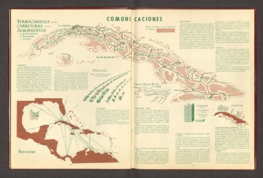
Author
[Canet Alvarez, Gerardo A., 1911-, Raisz, Erwin, 1893-1968, Harvard University. Institute of Geographical Exploration, Cuba. Ministerio de Agricultura]
Full Title
Comunicaciones.
List No
14350.033
Note
Map showing the geography of transportation and communication in Cuba. Title translates to: Communications. Features distribution of roads and railways in the country. Includes a bar scale. With three inset maps: Aerovías [= Airways] -- Líneas aéreas nacionales [= National airlines] -- Puertos [= Ports]. In addition, with charts and diagrams depicting vehicles and mail. Accompanied by descriptive text, which appears in Spanish, with English translations.
Author
[Geological Survey (U.S.), Shaw, W. James II., United States. Army]
Full Title
Major rail network : 1966 / W. James Shaw, II, U. S. Department of the Army, 1966.
List No
14359.174
Note
Transportation map representing the United States, featuring the geographic locations of the major railway network, including primary and secondary railroads, as of 1966. Map also shows political boundaries, time zones, topography, bodies of water, drainage, coastlines and islands. Relief shown with shading. Includes a legend, as well as a bar scale and scale statement. Presented with Albers Equal Area Projection. With two inset maps: Principal islands of Hawaii -- Alaska. Colored lithograph. Map is 43 x 66 cm, on double sheet 49 x 71 cm. Appears in Special subject maps section, subsection Economic : Transportation.
Author
[Weekly Dispatch, Weller, Edward, 1819-1884]
Full Title
Eastern Counties Railway : (Sheet 1, London to Ipswich Yarmouth & Norwich) -- (Sheet 2, London to Cambridge Ely & Norwich) / drawn & engraved by Edwd. Weller, 34 Red Lion Square ; E. Weller Lithogr.
List No
14360.065
Note
Eastern Counties Railway in England (Sheets 1 and 2). Shows political boundaries, counties, cities, railways, roads, canals, topography, vegetation, bodies of water, drainage, coastline, shoals and islands. Relief shown with contour lines. Includes latitudinal and longitudinal lines, as well as a legend and bar scale given in miles. With inset map: Harwich Branch. Hand-colored lithograph. Strip map divided into seven parts, together 45 x 65 cm, on two sheets, together 48 x 69 cm. Sheets presented in sequence. Appears in Vol. I : British.
Author
[Weekly Dispatch, Weller, Edward, 1819-1884]
Full Title
Great Northern Railway : (Sheet 1, London to Grantham & Nottingham) (Sheet 2, Continuation to York, Leeds &c.) / drawn & engraved by Edwd. Weller, 34 Red Lion Square ; E. Weller Lithogr.
List No
14360.066
Note
Map of the Great Northern Railway in England (Sheets 1 and 2). Shows political boundaries, counties, cities, railways, roads, canals, topography, vegetation, bodies of water and drainage. Relief shown with contour lines. Includes latitudinal and longitudinal lines, as well as a bar scale given in miles and compass roses. Hand-colored lithograph. Strip map divided into five parts, together 43 x 32 cm, on sheet 48 x 33 cm. Plate numbers for facing sheets handwritten in ink at upper left corner of sheet. Sheets 1 followed by maps entitled "(Sheet 2, Continuation to York, Leeds &c.) -- (Sheet 3, Loop or Lincolnshire Line from Peterborough)" on subsequent plates. Appears in Vol. I : British.
Author
[Weekly Dispatch, Weller, Edward, 1819-1884]
Full Title
Great Northern Railway : (Sheet 3, Loop or Lincolnshire Line from Peterborough) / drawn & engraved by Edwd. Weller, 34 Red Lion Square ; E. Weller Lithogr.
List No
14360.067
Note
Map of the Great Northern Railway in England (Sheet 3). Shows political boundaries, counties, cities, railways, roads, canals, topography, vegetation, bodies of water, drainage, coastlines and shoals. Relief shown with contour lines. Includes latitudinal and longitudinal lines, as well as a bar scale given in miles and compass roses. Hand-colored lithograph. Strip map divided into five parts, together 46 x 31 cm, on sheet 48 x 33 cm. Plate number handwritten in ink at upper right corner of sheet. Preceded by maps entitled "(Sheet 1, London to Grantham & Nottingham) -- (Sheet 3, Loop or Lincolnshire Line from Peterborough)" on previous plates. Appears in Vol. I : British.
Author
[Weekly Dispatch, Weller, Edward, 1819-1884]
Full Title
Great Western Railway : (Sheet 1, London to Reading, Oxford &c.) (Sheet IV, Oxford to Chester) / drawn & engraved by Edwd. Weller, 34 Red Lion Square ; E. Weller Lithogr.
List No
14360.068
Note
Map of the Great Western Railway in England (Sheets 1 and IV). Shows political boundaries, counties, cities, railways, roads, canals, topography, vegetation, bodies of water and drainage. Relief shown with contour lines. Includes latitudinal and longitudinal lines, as well as a bar scale given in miles and compass roses. Hand-colored lithograph. Strip map divided into five parts, together 45 x 32 cm, on sheet 48 x 33 cm. Plate numbers for facing sheets handwritten in ink at upper left corner of sheet; "4/8/60" in pencil at bottom of sheet. Followed by maps entitled (Sheet 2, Continuation to Bath and Bristol) -- (Sheet 3, Bristol to Exeter & Plymouth)" on subsequent plates. Appears in Vol. I : British.
Author
[Weekly Dispatch, Weller, Edward, 1819-1884]
Full Title
Great Western Railway : (Sheet 2, Continuation to Bath and Bristol) (Sheet 3, Bristol to Exeter & Plymouth)./ drawn & engraved by Edwd. Weller, 34 Red Lion Square ; E. Weller Lithogr.
List No
14360.069
Note
Map of the Great Western Railway in England (Sheets 2 and 3). Shows political boundaries, counties, cities, railways, roads, canals, topography, vegetation, bodies of water and drainage. Relief shown with contour lines. Includes latitudinal and longitudinal lines, as well as a bar scale given in miles and compass roses. Hand-colored lithograph. Strip map divided into four parts, together 44 x 31 cm, on sheet 48 x 33 cm. Plate numbers for facing sheets handwritten in ink at upper left corner of sheet; "25/8/61" in pencil at bottom of sheet. Preceded by maps entitled "(Sheet IV, Oxford to Chester) -- (Sheet IV, Oxford to Chester)" on previous plates; followed by "(Sheet 3, Bristol to Exeter & Plymouth)" on subsequent plate. Appears in Vol. I : British.
Author
[Weekly Dispatch, Weller, Edward, 1819-1884]
Full Title
London & Brighton Railway / drawn & engraved by Edwd. Weller, 34 Red Lion Square London ; E. Weller Lithogr.
List No
14360.070
Note
Map of the London & Brighton Railway in England. Shows political boundaries, counties, cities, railways, roads, canals, topography, vegetation, bodies of water, drainage and coastline. Relief shown with contour lines. Includes latitudinal and longitudinal lines, as well as a bar scale given in miles and compass roses. Hand-colored lithograph. Strip map divided into five parts, together 44 x 31 cm, on sheet 48 x 33 cm. Plate number handwritten in ink at upper right corner of sheet; "3/6/60" in pencil at bottom of sheet. Appears in Vol. I : British.
Author
[Weekly Dispatch, Weller, Edward, 1819-1884]
Full Title
North Western Railway : (Sheet 1, London to Birmingham) Sheet 2, Birmingham to Manchester & Liverpool)./ drawn & engraved by Edwd. Weller, 34 Red Lion Square ; E. Weller Lithogr.
List No
14360.071
Note
Map of the North Western Railway in England (Sheets 1 and 2). Shows political boundaries, counties, cities, railways, roads, canals, topography, vegetation, bodies of water, drainage and coastline. Relief shown with contour lines. Includes latitudinal and longitudinal lines, as well as a legend and bar scale given in miles. Hand-colored lithograph. Strip map divided into seven parts, together 45 x 65 cm, on two sheets, together 48 x 69 cm. Sheets presented in sequence. Appears in Vol. I : British.
Author
[Weekly Dispatch, Weller, Edward, 1819-1884]
Full Title
London & South-Western Railway / drawn & engraved by Edwd. Weller, 34 Red Lion Square ; E. Weller Lithogr.
List No
14360.072
Note
Map of the London & South-Western Railway in England. Shows political boundaries, counties, cities, railways, roads, canals, topography, vegetation, bodies of water, drainage, coastline, shoals and islands. Relief shown with contour lines. Includes latitudinal and longitudinal lines, as well as a legend, explanatory note and bar scale given in miles. Hand-colored lithograph. Strip map divided into four parts, together 65 x 45 cm, on double sheet 69 x 48 cm. Plate numbers handwritten in ink at lower and upper left corners of sheet; "20/5/60" in pencil at bottom of sheet. Appears in Vol. I : British.
Author
[Weekly Dispatch, Weller, Edward, 1819-1884]
Full Title
South Coast Railway : (Portsmouth to Brighton & Hastings) / drawn & engraved by Edwd. Weller, 34 Red Lion Square ; E. Weller Lithogr.
List No
14360.073
Note
Map of the South Coast Railway in England. Shows political boundaries, counties, cities, railways, roads, canals, topography, vegetation, bodies of water, drainage, coastline, shoals and islands. Relief shown with contour lines. Includes latitudinal and longitudinal lines, as well as a legend, explanatory note and bar scale given in miles. Hand-colored lithograph. Strip map divided into three parts, together 31 x 45 cm, on sheet 33 x 48 cm. Plate number handwritten in ink at lower and upper left corners of sheet; "22/7/60" in pencil at bottom of sheet. Appears in Vol. I : British.
Author
[Weekly Dispatch, Weller, Edward, 1819-1884]
Full Title
South Eastern Railway : (Dover & Hastings Branches) / drawn & engraved by Edwd. Weller, 34 Red Lion Square ; E. Weller Lithogr.
List No
14360.074
Note
Map of the South Eastern Railway in England. Shows political boundaries, counties, cities, railways, roads, canals, topography, vegetation, bodies of water, drainage, coastline, shoals and islands. Relief shown with contour lines. Includes latitudinal and longitudinal lines, as well as a legend and bar scale given in miles. Hand-colored lithograph. Strip map divided into three parts, together 45 x 31 cm, on sheet 48 x 33 cm. Plate number handwritten in ink at upper right corner of sheet; "1/7/60" in pencil at bottom of sheet. Appears in Vol. I : British.
Author
[Weekly Dispatch, Weller, Edward, 1819-1884]
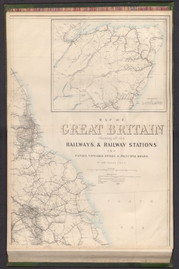
Full Title
Railway map of Great Britain : Showing all the railways, & railway stations, the canals, navigable rivers, & principal roads : (North east sheet) / by Edwd. Weller, F. R. G. S. ; engraved by Edwd. Weller, 34 Red Lion Square ; E. Weller Lithogr.
List No
14360.121
Note
Map of Great Britain, featuring railways and stations, canals, navigable rivers and roads (northeast sheet). Shows political boundaries, cities, railways, roads, canals, coal fields, bodies of water, drainage, coastlines, shoals and islands. Includes latitudinal and longitudinal lines, as well as a legend and bar scale given in British miles. With inset map: Continuation of Scotland. Hand-colored lithograph. Map is 65 x 46 cm, on double sheet 69 x 48 cm. Plate number handwritten in ink at lower left corner of sheet. Followed by maps entitled "(North west sheet) -- (South east sheet) -- (South west sheet)" on subsequent plates. Appears in Vol. I : British.
Author
[Weekly Dispatch, Weller, Edward, 1819-1884]
Full Title
Railway map of Great Britain : Showing all the railways, & railway stations, the canals, navigable rivers, & principal roads : (North west sheet) / by Edwd. Weller, F. R. G. S. ; engraved by Edwd. Weller, 34 Red Lion Square ; E. Weller Lithogr.
List No
14360.122
Note
Map of Great Britain, featuring railways and stations, canals, navigable rivers and roads (northwest sheet). Shows political boundaries, cities, railways, roads, canals, coal fields, bodies of water, drainage, coastlines, shoals and islands. Includes latitudinal and longitudinal lines. Hand-colored lithograph. Map is 65 x 46 cm, on double sheet 69 x 48 cm. Plate number handwritten in ink at lower left corner of sheet. Preceded by map entitled "(North west sheet)" on previous plate; followed by "(South east sheet) -- (South west sheet)" on subsequent plates. Appears in Vol. I : British.
Author
[Weekly Dispatch, Weller, Edward, 1819-1884]
Full Title
Railway map of Great Britain : Showing all the railways, & railway stations, the canals, navigable rivers, & principal roads : (South east sheet) / by Edwd. Weller, F. R. G. S. ; engraved by Edwd. Weller, 34 Red Lion Square ; E. Weller Lithogr.
List No
14360.123
Note
Map of Great Britain, featuring railways and stations, canals, navigable rivers and roads (southeast sheet). Shows political boundaries, cities, railways, roads, canals, coal fields, bodies of water, drainage, coastlines, shoals and islands. Includes latitudinal and longitudinal lines. With inset map: Railways in the vicinity of London. Hand-colored lithograph. Map is 65 x 46 cm, on double sheet 69 x 48 cm. Plate number handwritten in ink at lower left corner of sheet. Preceded by maps entitled "(North west sheet) -- (North west sheet)" on previous plates; followed by "(South west sheet)" on subsequent plate. Appears in Vol. I : British.
Author
[Weekly Dispatch, Weller, Edward, 1819-1884]
Full Title
Railway map of Great Britain : Showing all the railways, & railway stations, the canals, navigable rivers, & principal roads : (South west sheet) / by Edwd. Weller, F. R. G. S. ; engraved by Edwd. Weller, 34 Red Lion Square ; E. Weller Lithogr.
List No
14360.124
Note
Map of Great Britain, featuring railways and stations, canals, navigable rivers and roads (southwest sheet). Shows political boundaries, cities, railways, roads, canals, coal fields, bodies of water, drainage, coastlines, shoals and islands. Includes latitudinal and longitudinal lines. Hand-colored lithograph. Map is 65 x 46 cm, on double sheet 69 x 48 cm. Plate number handwritten in ink at lower left corner of sheet. Preceded by maps entitled "(North west sheet) -- (North west sheet) -- (South east sheet)" on previous plates. Appears in Vol. I : British.
Author
[Suomen Maantieteellinen Seura, Tilgmann, Ferdinand, 1832-1911]
Full Title
No. 27. Kulkuneuvot. = Kommunikationer. Aktiebolaget F. Tilgmann, Helsingfors 1897.
List No
14366.039
Note
Transportation map of Finland. Features railways, roads, trails and canals in 1897. Also shows cities, railways, bodies of water, drainage, coastlines and islands. Includes latitudinal and longitudinal lines, as well as a legend, bar scale and scale statement. Colored lithograph. Map is 58 x 41 cm, on double sheet 60 x 43 cm. Text presented in parallel Finnish and Swedish.
Author
[Suomen Maantieteellinen Seura, Tilgmann, Ferdinand, 1832-1911]
Full Title
Kulkuneuvot. = Communications. = Kommunikationer. Aktiebolaget F. Tilgmann, Helsingfors 1909.
List No
14367.099
Note
Transporation map of Finland. Features transportation routes, such as railways, roads, trails and canals in 1909. Also shows political boundaries, cities, bodies of water, drainage, coastlines and islands. Includes latitudinal and longitudinal lines, as well as a legend, bar scale and scale statement. Colored lithograph. Map is 58 x 40 cm, on double sheet 60 x 43 cm. Text presented in parallel Finnish, French and Swedish. Preceded by section title page for map.
Author
Cram, George Franklin, 1841-1928
Full Title
Maine. 1899, by Geo. F. Cram.
List No
14372.006
Note
Map of Maine. Shows political boundaries, counties, towns, railroads, steamship lines, topography, bodies of water, drainage, coastlines and islands. Relief shown with hachures. Includes key with explanation, latitudinal and longitudinal lines, as well as a bar scale given in miles. With alphanumeric grid corresponding to "Index of Maine" on pages 5-7 and 10. Colored lithograph. Map is 55 x 41 cm, on double sheet 67 x 45 cm. "Index of maps" and "Index of cities" in margins, providing navigation for atlas as a whole. Handwritten annotations in ink.
Author
Cram, George Franklin, 1841-1928
Full Title
New Hampshire and Vermont. 1899, by Geo. F. Cram.
List No
14372.009
Note
Map of New Hampshire and Vermont. Shows political boundaries, counties, towns, railroads, steamship lines, topography, bodies of water, drainage, coastlines and islands. Relief shown with hachures. Includes key with explanation, latitudinal and longitudinal lines, as well as a bar scale given in miles. With alphanumeric grid corresponding to "Index of New Hampshire" on pages 11-12, and "Index of Vermont" on pages 13 and 16. Colored lithograph. Map is 55 x 41 cm, on double sheet 67 x 45 cm. "Index of maps" and "Index of cities" in margins, providing navigation for atlas as a whole.
Author
Cram, George Franklin, 1841-1928
Full Title
Commercial railroad and county map of Massachusetts and Rhode Island. 1899, by Geo. F. Cram.
List No
14372.012
Note
Map of Massachusetts and Rhode Island. Shows political boundaries, counties, towns, railroads, steamship lines, topography, bodies of water, drainage, coastlines and islands. Relief shown with hachures. Includes key with explanation, latitudinal and longitudinal lines, as well as a bar scale given in miles. With alphanumeric grid corresponding to "Index of Massachusetts" on pages 17-19 and 22, and "Index of Rhode Island" on page 23. Colored lithograph. Map is 40 x 57 cm, on double sheet 45 x 67 cm. "Index of maps" and "Index of cities" in margins, providing navigation for atlas as a whole.
Author
Cram, George Franklin, 1841-1928
Full Title
Connecticut. 1899, by Geo. F. Cram.
List No
14372.015
Note
Map of Connecticut. Shows political boundaries, counties, towns, railroads, steamship lines, topography, bodies of water, drainage, coastlines and islands. Relief shown with hachures. Includes key with explanation, latitudinal and longitudinal lines, as well as a bar scale given in miles. With alphanumeric grid corresponding to "Index of Connecticut" on pages 24 and 26. Colored lithograph. Map is 27 x 40 cm, on sheet 33 x 45 cm. "Index of maps" and "Index of cities" in margins, providing navigation for atlas as a whole.
Author
Cram, George Franklin, 1841-1928
Full Title
New York : Western half. 1899, by Geo. F. Cram.
List No
14372.018
Note
Map of New York (western half). Shows political boundaries, counties, towns, railroads, steamship lines, topography, bodies of water, drainage, coastlines and islands. Relief shown with hachures. Includes key with explanation, latitudinal and longitudinal lines, as well as a bar scale given in miles. With alphanumeric grid corresponding to "Index of New York" on pages 27-29, 32-35, 38-41 and 44. Colored lithograph. Map, divided into two parts, is 55 x 40 cm, on double sheet 67 x 45 cm. "Index of maps" and "Index of cities" in margins, providing navigation for atlas as a whole. Eastern half of map follows on pages 36-37.
Author
Cram, George Franklin, 1841-1928
Full Title
New York : Eastern half. 1899, by Geo. F. Cram.
List No
14372.021
Note
Map of New York (eastern half). Shows political boundaries, counties, towns, railroads, steamship lines, topography, bodies of water, drainage, coastlines and islands. Relief shown with hachures. Includes key with explanation, latitudinal and longitudinal lines, as well as a bar scale given in miles. With alphanumeric grid corresponding to "Index of New York" on pages 27-29, 32-35, 38-41 and 44. Colored lithograph. Map, divided into two parts, is 56 x 40 cm, on double sheet 67 x 45 cm. "Index of maps" and "Index of cities" in margins, providing navigation for atlas as a whole. Western half of map precedes on pages 30-31.
Author
Cram, George Franklin, 1841-1928
Full Title
New York. 1899, by Geo. F. Cram.
List No
14372.025
Note
Map of New York. Shows political boundaries, counties, towns, railroads, steamship lines, topography, bodies of water, drainage, coastlines and islands. Relief shown with hachures. Includes key with explanation, latitudinal and longitudinal lines. With alphanumeric grid corresponding to "Index of New York" on pages 27-29, 32-35, 38-41 and 44. Colored lithograph. Map is 44 x 56 cm, on double sheet 45 x 67 cm. "Index of maps" and "Index of cities" in margins, providing navigation for atlas as a whole.
Author
Cram, George Franklin, 1841-1928
Full Title
Western half of Pennsylvania. 1899, by Geo. F. Cram.
List No
14372.032
Note
Map of Pennsylvania (western half). Shows political boundaries, counties, towns, railroads, steamship lines, topography, bodies of water, drainage, coastlines and islands. Relief shown with hachures. Includes key with explanation, latitudinal and longitudinal lines, as well as a bar scale given in miles. With alphanumeric grid corresponding to "Index of Pennsylvania" on pages 45-55, 58-61 and 64-67. Colored lithograph. Map is 54 x 42 cm, on double sheet 67 x 45 cm. "Index of maps" and "Index of cities" in margins, providing navigation for atlas as a whole. Eastern half of map follows on pages 62-63.
Author
Cram, George Franklin, 1841-1928
Full Title
Eastern half of Pennsylvania. 1899, by Geo. F. Cram.
List No
14372.035
Note
Map of Pennsylvania (eastern half). Shows political boundaries, counties, towns, railroads, steamship lines, topography, bodies of water, drainage, coastlines and islands. Relief shown with hachures. Includes key with explanation, latitudinal and longitudinal lines, as well as a bar scale given in miles. With alphanumeric grid corresponding to "Index of Pennsylvania" on pages 45-55, 58-61 and 64-67. Colored lithograph. Map is 54 x 43 cm, on double sheet 67 x 45 cm. "Index of maps" and "Index of cities" in margins, providing navigation for atlas as a whole. Western half of map precedes on pages 56-57.
Author
Cram, George Franklin, 1841-1928
Full Title
Pennsylvania. 1899, by Geo. F. Cram.
List No
14372.039
Note
Map of Pennsylvania. Shows political boundaries, counties, towns, railroads, steamship lines, topography, bodies of water, drainage, coastlines and islands. Relief shown with hachures. Includes key with explanation, latitudinal and longitudinal lines, as well as a bar scale given in miles. With alphanumeric grid corresponding to "Index of Pennsylvania" on pages 45-55, 58-61 and 64-67. Colored lithograph. Map is 40 x 55 cm, on double sheet 45 x 67 cm. "Index of maps" and "Index of cities" in margins, providing navigation for atlas as a whole.
Author
Cram, George Franklin, 1841-1928
Full Title
New Jersey. 1899, by Geo. F. Cram.
List No
14372.042
Note
Map of New Jersey. Shows political boundaries, counties, towns, railroads, steamship lines, topography, bodies of water, drainage, coastlines and islands. Relief shown with hachures. Includes key with explanation, latitudinal and longitudinal lines, as well as a bar scale given in miles. Inset map: Environs of Hudson County. Colored lithograph. With alphanumeric grid corresponding to "Index of New Jersey" on pages 71-73 and 76. Map is 55 x 40 cm, on double sheet 67 x 45 cm. "Index of maps" and "Index of cities" in margins, providing navigation for atlas as a whole.
Author
Cram, George Franklin, 1841-1928
Full Title
Maryland and Delaware. 1899, by Geo. F. Cram.
List No
14372.046
Note
Map of Maryland and Delaware. Shows political boundaries, counties, towns, railroads, steamship lines, topography, bodies of water, drainage, coastlines and islands. Relief shown with hachures. Includes key with explanation, latitudinal and longitudinal lines, as well as a bar scale given in miles. Inset map: Baltimore County. With alphanumeric grid corresponding to "Index of Maryland" on pages 77-81, and "Index of Delaware" on page 84. Colored lithograph. Map is 39 x 55 cm, on double sheet 45 x 67 cm. "Index of maps" and "Index of cities" in margins, providing navigation for atlas as a whole.
Author
Cram, George Franklin, 1841-1928
Full Title
Western half of Virginia and West Virginia. 1899, by Geo. F. Cram.
List No
14372.052
Note
Map of Virginia and West Virginia (western half). Shows political boundaries, counties, towns, railroads, steamship lines, topography, bodies of water, drainage, coastlines and islands. Relief shown with hachures. Includes key with explanation, latitudinal and longitudinal lines, as well as a bar scale given in miles. With alphanumeric grid corresponding to "Index of Virginia" on pages 85-93 and 96-98, and "Index of West Virginia" on pages 99, 102-105 and 108-110. Colored lithograph. Map is 55 x 43 cm, on double sheet 67 x 45 cm. "Index of maps" and "Index of cities" in margins, providing navigation for atlas as a whole. Eastern half of map follows on pages 100-101.
Author
Cram, George Franklin, 1841-1928
Full Title
Eastern half of Virginia and West Virginia. 1899, by Geo. F. Cram.
List No
14372.055
Note
Map of Virginia and West Virginia (eastern half). Shows political boundaries, counties, towns, railroads, steamship lines, topography, bodies of water, drainage, coastlines and islands. Relief shown with hachures. Includes key with explanation, latitudinal and longitudinal lines, as well as a bar scale given in miles. With alphanumeric grid corresponding to "Index of Virginia" on pages 85-93 and 96-98, and "Index of West Virginia" on pages 99, 102-105 and 108-110. Colored lithograph. Map is 55 x 42 cm, on double sheet 67 x 45 cm. "Index of maps" and "Index of cities" in margins, providing navigation for atlas as a whole. Western half of map precedes on pages 94-95.
Author
Cram, George Franklin, 1841-1928
Full Title
Virginia and West Virginia. 1899, by Geo. F. Cram.
List No
14372.059
Note
Map of Virginia and West Virginia. Shows political boundaries, counties, towns, railroads, steamship lines, topography, bodies of water, drainage, coastlines and islands. Relief shown with hachures. Includes key with explanation, latitudinal and longitudinal lines, as well as a bar scale given in miles. Inset map: South west part of Virginia. With alphanumeric grid corresponding to "Index of Virginia" on pages 85-93 and 96-98, and "Index of West Virginia" on pages 99, 102-105 and 108-110. Colored lithograph. Map is 40 x 55 cm, on double sheet 45 x 67 cm. "Index of maps" and "Index of cities" in margins, providing navigation for atlas as a whole.
Author
Cram, George Franklin, 1841-1928
Full Title
Ohio : North half. 1899, by Geo. F. Cram.
List No
14372.063
Note
Map of Ohio (northern half). Shows political boundaries, counties, towns, railroads, steamship lines, topography, bodies of water, drainage, coastlines and islands. Relief shown with hachures. Includes key with explanation, latitudinal and longitudinal lines, as well as a bar scale given in miles. With alphanumeric grid corresponding to "Index of Ohio" on pages 111-113, 116-119, 122-125 and 128. Colored lithograph. Map is 40 x 54 cm, on double sheet 45 x 67 cm. "Index of maps" and "Index of cities" in margins, providing navigation for atlas as a whole. Southern half of map follows on pages 120-121.
Author
Cram, George Franklin, 1841-1928
Full Title
Ohio : [South half]. 1899, by Geo. F. Cram.
List No
14372.066
Note
Map of Ohio (southern half). Shows political boundaries, counties, towns, railroads, steamship lines, topography, bodies of water, drainage, coastlines and islands. Relief shown with hachures. Includes key with explanation, latitudinal and longitudinal lines, as well as a bar scale given in miles. Inset map: Map of Hamilton County, Ohio. With alphanumeric grid corresponding to "Index of Ohio" on pages 111-113, 116-119, 122-125 and 128. Colored lithograph. Map is 40 x 55 cm, on double sheet 45 x 67 cm. "Index of maps" and "Index of cities" in margins, providing navigation for atlas as a whole. Southern half of map precedes on pages 114-115.
Author
Cram, George Franklin, 1841-1928
Full Title
Ohio. 1899, by Geo. F. Cram.
List No
14372.070
Note
Map of Ohio. Shows political boundaries, counties, towns, railroads, steamship lines, topography, bodies of water, drainage, coastlines and islands. Relief shown with hachures. Includes key with explanation, latitudinal and longitudinal lines, as well as a bar scale given in miles. With alphanumeric grid corresponding to "Index of Ohio" on pages 111-113, 116-119, 122-125 and 128. Colored lithograph. Map is 42 x 55 cm, on double sheet 45 x 67 cm. "Index of maps" and "Index of cities" in margins, providing navigation for atlas as a whole.
Author
Cram, George Franklin, 1841-1928
Full Title
Indiana. 1899, by Geo. F. Cram.
List No
14372.081
Note
Map of Indiana. Shows political boundaries, counties, towns, railroads, steamship lines, topography, bodies of water, drainage, coastlines and islands. Relief shown with hachures. Includes key with explanation, latitudinal and longitudinal lines, as well as a bar scale given in miles. With alphanumeric grid corresponding to "Index of Indiana" on pages 141-147 and 150-151. Colored lithograph. Map is 55 x 40 cm, on double sheet 67 x 45 cm. "Index of maps" and "Index of cities" in margins, providing navigation for atlas as a whole.
Author
Cram, George Franklin, 1841-1928
Full Title
Illinois : Northern half. 1899, by Geo. F. Cram.
List No
14372.084
Note
Map of Illinois (northern half). Shows political boundaries, counties, towns, railroads, steamship lines, topography, bodies of water, drainage, coastlines and islands. Relief shown with hachures. Includes key with explanation, latitudinal and longitudinal lines, as well as a bar scale given in miles. With alphanumeric grid corresponding to "Index of Illinois" on pages 152-153, 156-159, 162-165 and 168. Colored lithograph. Map is 40 x 55 cm, on double sheet 45 x 67 cm. "Index of maps" and "Index of cities" in margins, providing navigation for atlas as a whole. Southern half of map follows on pages 160-161.
Author
Cram, George Franklin, 1841-1928
Full Title
Illinois : Southern half. 1899, by Geo. F. Cram.
List No
14372.087
Note
Map of Illinois (southern half). Shows political boundaries, counties, towns, railroads, steamship lines, topography, bodies of water, drainage, coastlines and islands. Relief shown with hachures. Includes key with explanation, latitudinal and longitudinal lines, as well as a bar scale given in miles. Inset map: Chicago and vicinity. With alphanumeric grid corresponding to "Index of Illinois" on pages 152-153, 156-159, 162-165 and 168. Colored lithograph. Map is 40 x 55 cm, on double sheet 45 x 67 cm. "Index of maps" and "Index of cities" in margins, providing navigation for atlas as a whole. Northern half of map precedes on pages 154-155.
Author
Cram, George Franklin, 1841-1928
Full Title
Illinois. 1899, by Geo. F. Cram.
List No
14372.091
Note
Map of Illinois. Shows political boundaries, counties, towns, railroads, steamship lines, topography, bodies of water, drainage, coastlines and islands. Relief shown with hachures. Includes key with explanation, latitudinal and longitudinal lines, as well as a bar scale given in miles. Inset map: Part of Cook County. With alphanumeric grid corresponding to "Index of Illinois" on pages 152-153, 156-159, 162-165 and 168. Colored lithograph. Map is 55 x 40 cm, on double sheet 67 x 45 cm. "Index of maps" and "Index of cities" in margins, providing navigation for atlas as a whole.
Author
Cram, George Franklin, 1841-1928
Full Title
Iowa. 1899, by Geo. F. Cram.
List No
14372.096
Note
Map of Iowa. Shows political boundaries, counties, towns, railroads, steamship lines, topography, bodies of water, drainage, coastlines and islands. Relief shown with hachures. Includes key with explanation, as well as latitudinal and longitudinal lines. With alphanumeric grid corresponding to "Index of Iowa" on pages 169-175. Colored lithograph. Map is 40 x 55 cm, on double sheet 45 x 67 cm. "Index of maps" and "Index of cities" in margins, providing navigation for atlas as a whole.
Author
Cram, George Franklin, 1841-1928
Full Title
Missouri. 1899, by Geo. F. Cram.
List No
14372.102
Note
Map of Missouri. Shows political boundaries, counties, towns, railroads, steamship lines, topography, bodies of water, drainage, coastlines and islands. Relief shown with hachures. Includes key with explanation, latitudinal and longitudinal lines, as well as a bar scale given in miles. Inset map: Vicinity of St. Louis. With alphanumeric grid corresponding to "Index of Missouri" on pages 179-187 and 190-191. Colored lithograph. Map is 41 x 52 cm, on double sheet 45 x 67 cm. "Index of maps" and "Index of cities" in margins, providing navigation for atlas as a whole.
Author
Cram, George Franklin, 1841-1928
Full Title
Kansas. 1899, by Geo. F. Cram.
List No
14372.107
Note
Map of Kansas. Shows political boundaries, counties, towns, railroads, topography, bodies of water, drainage, coastlines and islands. Relief shown with hachures. Includes key with explanation, latitudinal and longitudinal lines, as well as a bar scale given in miles. With alphanumeric grid corresponding to "Index of Kansas" on pages 192-197 and 200. Colored lithograph. Map is 39 x 55 cm, on double sheet 45 x 67 cm. "Index of maps" and "Index of cities" in margins, providing navigation for atlas as a whole.
Author
Cram, George Franklin, 1841-1928
Full Title
Nebraska. 1899, by Geo. F. Cram.
List No
14372.110
Note
Map of Nebraska. Shows political boundaries, counties, towns, railroads, steamship lines, topography, bodies of water, drainage, coastlines and islands. Relief shown with hachures. Includes key with explanation, latitudinal and longitudinal lines, as well as a bar scale given in miles. With alphanumeric grid corresponding to "Index of Nebraska" on pages 201-203 and 206-207. Colored lithograph. Map is 40 x 57 cm, on double sheet 45 x 67 cm. "Index of maps" and "Index of cities" in margins, providing navigation for atlas as a whole.
Author
Cram, George Franklin, 1841-1928
Full Title
Wisconsin. 1899, by Geo. F. Cram.
List No
14372.119
Note
Map of Wisconsin. Shows political boundaries, counties, towns, railroads, steamship lines, topography, bodies of water, drainage, coastlines and islands. Relief shown with hachures. Includes key with explanation, latitudinal and longitudinal lines, as well as a bar scale given in miles. Inset map: Milwaukee. With alphanumeric grid corresponding to "Index of Wisconsin" on pages 216-221 and 224-225. Colored lithograph. Map is 55 x 40 cm, on double sheet 67 x 45 cm. "Index of maps" and "Index of cities" in margins, providing navigation for atlas as a whole.
Author
Cram, George Franklin, 1841-1928
Full Title
North Dakota. 1899, by Geo. F. Cram.
List No
14372.127
Note
Map of North Dakota. Shows political boundaries, counties, towns, railroads, steamship lines, topography, bodies of water, drainage, coastlines and islands. Relief shown with hachures. Includes key with explanation, latitudinal and longitudinal lines, as well as a bar scale given in miles. With alphanumeric grid corresponding to "Index of North Dakota" on pages 235-236. Colored lithograph. Map is 40 x 55 cm, on double sheet 67 x 45 cm. "Index of maps" and "Index of cities" in margins, providing navigation for atlas as a whole.
Author
Cram, George Franklin, 1841-1928
Full Title
South Dakota. 1899, by Geo. F. Cram.
List No
14372.129
Note
Map of South Dakota. Shows political boundaries, counties, towns, railroads, steamship lines, topography, bodies of water, drainage, coastlines and islands. Relief shown with hachures. Includes key with explanation, latitudinal and longitudinal lines, as well as a bar scale given in miles. With alphanumeric grid corresponding to "Index of South Dakota" on pages 240-241 and 244. Colored lithograph. Map is 40 x 55 cm, on double sheet 67 x 45 cm. "Index of maps" and "Index of cities" in margins, providing navigation for atlas as a whole.
Author
Cram, George Franklin, 1841-1928
Full Title
Kentucky and Tennessee : Western half. 1899, by Geo. F. Cram.
List No
14372.135
Note
Map of Kentucky and Tennessee (western half). Shows political boundaries, counties, towns, railroads, steamship lines, topography, bodies of water, drainage, coastlines and islands. Relief shown with hachures. Includes key with explanation, latitudinal and longitudinal lines, as well as a bar scale given in miles. With alphanumeric grid corresponding to "Index of Kentucky" on pages 254-255, 260-261 and 266-267; "Index of Tennessee" on pages 257-259, 262-265 and 268-269. Colored lithograph. Map is 50 x 41 cm, on double sheet 67 x 45 cm. "Index of maps" and "Index of cities" in margins, providing navigation for atlas as a whole. Eastern half of map follows on pages 260-261.
Author
Cram, George Franklin, 1841-1928
Full Title
Kentucky and Tennessee : Eastern half. 1899, by Geo. F. Cram.
List No
14372.138
Note
Map of Kentucky and Tennessee (eastern half). Shows political boundaries, counties, towns, railroads, steamship lines, topography, bodies of water, drainage, coastlines and islands. Relief shown with hachures. Includes key with explanation, latitudinal and longitudinal lines, as well as a bar scale given in miles. With alphanumeric grid corresponding to "Index of Kentucky" on pages 254-255, 260-261 and 266-267; "Index of Tennessee" on pages 257-259, 262-265 and 268-269. Colored lithograph. Map is 50 x 39 cm, on double sheet 67 x 45 cm. "Index of maps" and "Index of cities" in margins, providing navigation for atlas as a whole. Eastern half of map precedes on pages 254-255.
Author
Cram, George Franklin, 1841-1928
Full Title
Kentucky; Tennessee. 1899, by Geo. F. Cram.
List No
14372.142
Note
Map of Kentucky and Tennessee. Shows political boundaries, counties, towns, railroads, steamship lines, topography, bodies of water, drainage, coastlines and islands. Relief shown with hachures. Includes keys with explanations, latitudinal and longitudinal lines, as well as bar scales given in miles. Inset map: Vicinity of Covington and Newport. With alphanumeric grid corresponding to "Index of Kentucky" on pages 254-255, 260-261 and 266-267; "Index of Tennessee" on pages 257-259, 262-265 and 268-269. Colored lithograph. Map is 39 x 58 cm, on double sheet 45 x 67 cm. "Index of maps" and "Index of cities" in margins, providing navigation for atlas as a whole.
Author
Cram, George Franklin, 1841-1928
Full Title
Western part of North and South Carolina. 1899, by Geo. F. Cram.
List No
14372.147
Note
Map of North Carolina and South Carolina (western half). Shows political boundaries, counties, towns, railroads, steamship lines, topography, bodies of water, drainage, coastlines and islands. Relief shown with hachures. Includes key with explanation, latitudinal and longitudinal lines, as well as a bar scale given in miles. With alphanumeric grid corresponding to "Index of North Carolina" on pages 276-277, 282-283 and 288-289; "Index of South Carolina" on pages 281 and 284-287. Colored lithograph. Map is 57 x 43 cm, on double sheet 67 x 45 cm. "Index of maps" and "Index of cities" in margins, providing navigation for atlas as a whole. Eastern half of map follows on pages 282-283.
Author
Cram, George Franklin, 1841-1928
Full Title
Eastern part of North and South Carolina. 1899, by Geo. F. Cram.
List No
14372.150
Note
Map of North Carolina and South Carolina (eastern half). Shows political boundaries, counties, towns, railroads, steamship lines, topography, bodies of water, drainage, coastlines and islands. Relief shown with hachures. Includes key with explanation, latitudinal and longitudinal lines, as well as a bar scale given in miles. With alphanumeric grid corresponding to "Index of North Carolina" on pages 276-277, 282-283 and 288-289; "Index of South Carolina" on pages 281 and 284-287. Colored lithograph. Map is 56 x 43 cm, on double sheet 67 x 45 cm. "Index of maps" and "Index of cities" in margins, providing navigation for atlas as a whole. Western half of map precedes on pages 276-277.
Author
Cram, George Franklin, 1841-1928
Full Title
North & South Carolina. 1899, by Geo. F. Cram.
List No
14372.154
Note
Map of North Carolina and South Carolina. Shows political boundaries, counties, towns, railroads, steamship lines, topography, bodies of water, drainage, coastlines and islands. Relief shown with hachures. Includes key with explanation, latitudinal and longitudinal lines, as well as a bar scale given in miles. With alphanumeric grid corresponding to "Index of North Carolina" on pages 276-277, 282-283 and 288-289; "Index of South Carolina" on pages 281 and 284-287. Colored lithograph. Map is 40 x 55 cm, on double sheet 45 x 67 cm. "Index of maps" and "Index of cities" in margins, providing navigation for atlas as a whole.
Author
Cram, George Franklin, 1841-1928
Full Title
Georgia. 1899, by Geo. F. Cram.
List No
14372.159
Note
Map of Georgia. Shows political boundaries, counties, towns, railroads, steamship lines, topography, bodies of water, drainage, coastlines and islands. Relief shown with hachures. Includes key with explanation, latitudinal and longitudinal lines, as well as a bar scale given in miles. With alphanumeric grid corresponding to "Index of Georgia" on pages 290-297 and 300-301. Colored lithograph. Map is 56 x 41 cm, on double sheet 67 x 45 cm. "Index of maps" and "Index of cities" in margins, providing navigation for atlas as a whole.
Author
Cram, George Franklin, 1841-1928
Full Title
Florida. 1899, by Geo. F. Cram.
List No
14372.162
Note
Map of Florida. Shows political boundaries, counties, towns, railroads, steamship lines, topography, marshlands, bodies of water, drainage, coastlines and islands. Relief shown with hachures. Includes key with explanation, latitudinal and longitudinal lines, as well as a bar scale given in miles. Inset map: North-Western portion of Florida. With alphanumeric grid corresponding to "Index of Florida" on pages 302-303, 306-307 and 307 1/2. Colored lithograph. Map is 57 x 41 cm, on double sheet 67 x 45 cm. "Index of maps" and "Index of cities" in margins, providing navigation for atlas as a whole.
Author
Cram, George Franklin, 1841-1928
Full Title
Alabama. 1899, by Geo. F. Cram.
List No
14372.168
Note
Map of Alabama. Shows political boundaries, counties, towns, railroads, steamship lines, topography, marshlands, bodies of water, drainage, coastlines and islands. Relief shown with hachures. Includes key with explanation, latitudinal and longitudinal lines, as well as a bar scale given in miles. With alphanumeric grid corresponding to "Index of Alabama" on pages 308-313 and 316-317. Colored lithograph. Map is 55 x 40 cm, on double sheet 67 x 45 cm. "Index of maps" and "Index of cities" in margins, providing navigation for atlas as a whole.
Author
Cram, George Franklin, 1841-1928
Full Title
Mississippi. 1899, by Geo. F. Cram.
List No
14372.172
Note
Map of Mississippi. Shows political boundaries, counties, towns, railroads, steamship lines, topography, marshlands, bodies of water, drainage, coastlines and islands. Relief shown with hachures. Includes key with explanation, latitudinal and longitudinal lines, as well as a bar scale given in miles. With alphanumeric grid corresponding to "Index of Mississippi" on pages 318-321 and 324-324 1/2. Colored lithograph. Map is 55 x 40 cm, on double sheet 67 x 45 cm. "Index of maps" and "Index of cities" in margins, providing navigation for atlas as a whole.
Author
Cram, George Franklin, 1841-1928
Full Title
Louisiana. 1899, by Geo. F. Cram.
List No
14372.176
Note
Map of Louisiana. Shows political boundaries, counties, towns, railroads, steamship lines, topography, marshlands, bodies of water, drainage, coastlines and islands. Relief shown with hachures. Includes key with explanation, latitudinal and longitudinal lines, as well as a bar scale given in miles. With alphanumeric grid corresponding to "Index of Louisiana" on pages 325-327 and 330-331. Colored lithograph. Map is 55 x 41 cm, on double sheet 67 x 45 cm. "Index of maps" and "Index of cities" in margins, providing navigation for atlas as a whole.
Author
Cram, George Franklin, 1841-1928
Full Title
Arkansas. 1899, by Geo. F. Cram.
List No
14372.181
Note
Map of Arkansas. Shows political boundaries, counties, towns, railroads, steamship lines, topography, marshlands, bodies of water, drainage, coastlines and islands. Relief shown with hachures. Includes key with explanation, latitudinal and longitudinal lines, as well as a bar scale given in miles. With alphanumeric grid corresponding to "Index of Arkansas" on pages 332-337 and 340. Colored lithograph. Map is 40 x 55 cm, on double sheet 45 x 67 cm. "Index of maps" and "Index of cities" in margins, providing navigation for atlas as a whole.
Author
Cram, George Franklin, 1841-1928
Full Title
Western half of Texas. 1899, by Geo. F. Cram.
List No
14372.183
Note
Map of Texas (western half). Shows political boundaries, counties, towns, railroads, steamship lines, topography, bodies of water, drainage, coastlines and islands. Relief shown with hachures. Includes key with explanation, latitudinal and longitudinal lines, as well as a bar scale given in miles. With alphanumeric grid corresponding to "Index of Texas" on pages 341, 344-347, 350-353 and 356. Colored lithograph. Map is 55 x 42 cm, on double sheet 67 x 45 cm. "Index of maps" and "Index of cities" in margins, providing navigation for atlas as a whole. Eastern half of map follows on pages 348-349.
Author
Cram, George Franklin, 1841-1928
Full Title
Eastern half of Texas. 1899, by Geo. F. Cram.
List No
14372.186
Note
Map of Texas (eastern half). Shows political boundaries, counties, towns, railroads, steamship lines, topography, bodies of water, drainage, coastlines and islands. Relief shown with hachures. Includes key with explanation, latitudinal and longitudinal lines, as well as a bar scale given in miles. With alphanumeric grid corresponding to "Index of Texas" on pages 341, 344-347, 350-353 and 356. Colored lithograph. Map is 57 x 39 cm, on double sheet 67 x 45 cm. "Index of maps" and "Index of cities" in margins, providing navigation for atlas as a whole. Western half of map precedes on pages 342-343.
Author
Cram, George Franklin, 1841-1928
Full Title
Texas. 1899, by Geo. F. Cram.
List No
14372.190
Note
Map of Texas. Shows political boundaries, counties, towns, railroads, steamship lines, topography, bodies of water, drainage, coastlines and islands. Relief shown with hachures. Includes key with explanation, latitudinal and longitudinal lines, as well as a bar scale given in miles. With alphanumeric grid corresponding to "Index of Texas" on pages 341, 344-347, 350-353 and 356. Colored lithograph. Map, divided into two parts, is 41 x 55 cm, on double sheet 45 x 67 cm. "Index of maps" and "Index of cities" in margins, providing navigation for atlas as a whole.
Author
Cram, George Franklin, 1841-1928
Full Title
Arizona. 1899, by Geo. F. Cram.
List No
14372.195
Note
Map of Arizona. Shows political boundaries, counties, towns, railroads, topography, bodies of water, drainage, coastlines and islands. Relief shown with hachures. Includes key with explanation, latitudinal and longitudinal lines, as well as a bar scale given in miles. With alphanumeric grid corresponding to "Index of Arizona Territory" on page 363. Colored lithograph. Map is 52 x 40 cm, on double sheet 67 x 45 cm. "Index of maps" and "Index of cities" in margins, providing navigation for atlas as a whole.
Author
Cram, George Franklin, 1841-1928
Full Title
New Mexico. 1899, by Geo. F. Cram.
List No
14372.197
Note
Map of New Mexico. Shows political boundaries, counties, towns, railroads, topography, bodies of water, drainage, coastlines and islands. Relief shown with hachures. Includes key with explanation, latitudinal and longitudinal lines, as well as a bar scale given in miles. With alphanumeric grid corresponding to "Index of New Mexico Territory" on pages 366-367. Colored lithograph. Map is 56 x 40 cm, on double sheet 67 x 45 cm. "Index of maps" and "Index of cities" in margins, providing navigation for atlas as a whole.
Author
Cram, George Franklin, 1841-1928
Full Title
California and Nevada : Northern half. 1899, by Geo. F. Cram.
List No
14372.202
Note
Map of California and Nevada (northern half). Shows political boundaries, counties, towns, railroads, topography, bodies of water, drainage, coastlines and islands. Relief shown with hachures. Includes key with explanation, latitudinal and longitudinal lines, as well as a bar scale given in miles. With alphanumeric grid corresponding to "Index of Nevada" on page 371; "Index of California" on pages 374-375, 378-379 and 382. Colored lithograph. Map is 41 x 57 cm, on double sheet 45 x 67 cm. "Index of maps" and "Index of cities" in margins, providing navigation for atlas as a whole. Southern half of map follows on pages 380-381.
Author
Cram, George Franklin, 1841-1928
Full Title
California and Nevada : Southern half. 1899, by Geo. F. Cram.
List No
14372.204
Note
Map of California and Nevada (southern half). Shows political boundaries, counties, towns, railroads, topography, bodies of water, drainage, coastlines and islands. Relief shown with hachures. Includes key with explanation, latitudinal and longitudinal lines, as well as a bar scale given in miles. With alphanumeric grid corresponding to "Index of Nevada" on page 371; "Index of California" on pages 374-375, 378-379 and 382. Colored lithograph. Map is 41 x 56 cm, on double sheet 45 x 67 cm. "Index of maps" and "Index of cities" in margins, providing navigation for atlas as a whole. Northern half of map precedes on pages 376-377.
Author
Cram, George Franklin, 1841-1928
Full Title
Providence.
List No
14372.207
Note
Map of Providence, Rhode Island. Shows railroads, streets, parks, hills, bodies of water, drainage, coastlines and islands. Colored lithograph. Map is 38 x 28 cm, on sheet 45 x 33 cm.
Author
Cram, George Franklin, 1841-1928
Full Title
California. 1899, by Geo. F. Cram.
List No
14372.208
Note
Map of California. Shows political boundaries, counties, towns, railroads, topography, bodies of water, drainage, coastlines and islands. Relief shown with hachures. Includes key with explanation, latitudinal and longitudinal lines, as well as a bar scale given in miles. Two inset maps: Map of sections surrounding San Francisco -- Hawaiian or Sandwich Islands. With alphanumeric grid corresponding to "Index of California" on pages 374-375, 378-379 and 382. Colored lithograph. Map is 55 x 40 cm, on double sheet 67 x 45 cm. "Index of maps" and "Index of cities" in margins, providing navigation for atlas as a whole.
Author
Cram, George Franklin, 1841-1928
Full Title
Map of the city of New Haven.
List No
14372.209
Note
Map of New Haven, Connecticut. Shows railroads, streets, parks, hills, bodies of water, drainage, coastlines and islands. Includes circles of distance from the city center, given in miles. Colored lithograph. Map is 38 x 27 cm, on sheet 45 x 33 cm.
Author
Cram, George Franklin, 1841-1928
Full Title
Utah. 1899, by Geo. F. Cram.
List No
14372.213
Note
Map of Utah. Shows political boundaries, counties, towns, railroads, topography, bodies of water, drainage, coastlines and islands. Relief shown with hachures. Includes key with explanation, latitudinal and longitudinal lines, as well as a bar scale given in miles. With alphanumeric grid corresponding to "Index of Utah" on page 391. Colored lithograph. Map is 55 x 38 cm, on double sheet 67 x 45 cm. "Index of maps" and "Index of cities" in margins, providing navigation for atlas as a whole.
Author
Cram, George Franklin, 1841-1928
Full Title
Wyoming. 1899, by Geo. F. Cram.
List No
14372.215
Note
Map of Wyoming. Shows political boundaries, counties, towns, railroads, topography, bodies of water, drainage, coastlines and islands. Relief shown with hachures. Includes key with explanation, latitudinal and longitudinal lines, as well as a bar scale given in miles. With alphanumeric grid corresponding to "Index of Wyoming" on pages 395 and 398. Colored lithograph. Map is 40 x 56 cm, on double sheet 45 x 67 cm. "Index of maps" and "Index of cities" in margins, providing navigation for atlas as a whole.
Author
Cram, George Franklin, 1841-1928
Full Title
Idaho. 1899, by Geo. F. Cram.
List No
14372.218
Note
Map of Idaho. Shows political boundaries, counties, towns, railroads, steamship lines, topography, bodies of water, drainage, coastlines and islands. Relief shown with hachures. Includes key with explanation, latitudinal and longitudinal lines, as well as a bar scale given in miles. With alphanumeric grid corresponding to "Index of Idaho" on pages 399 and 402. Colored lithograph. Map is 55 x 39 cm, on double sheet 67 x 45 cm. "Index of maps" and "Index of cities" in margins, providing navigation for atlas as a whole.
Author
Cram, George Franklin, 1841-1928
Full Title
Western part of Washington. 1899, by Geo. F. Cram.
List No
14372.220
Note
Map of Washington (western half). Shows political boundaries, counties, towns, Indian reservations, mines, railroads, topography, bodies of water, drainage, coastlines and islands. Relief shown with hachures. Includes key with explanation, latitudinal and longitudinal lines, as well as a bar scale given in miles. With alphanumeric grid corresponding to "Index of Washington" on pages 403 and 406-407. Colored lithograph. Map is 55 x 40 cm, on double sheet 67 x 45 cm. "Index of maps" and "Index of cities" in margins, providing navigation for atlas as a whole. Eastern half of map follows on pages 408-409.
Author
Cram, George Franklin, 1841-1928
Full Title
Eastern part of Washington. 1899, by Geo. F. Cram.
List No
14372.222
Note
Map of Washington (eastern half). Shows political boundaries, counties, towns, Indian reservations, mines, railroads, topography, bodies of water, drainage, coastlines and islands. Relief shown with hachures. Includes key with explanation, latitudinal and longitudinal lines, as well as a bar scale given in miles. With alphanumeric grid corresponding to "Index of Washington" on pages 403 and 406-407. Colored lithograph. Map is 55 x 40 cm, on double sheet 67 x 45 cm. "Index of maps" and "Index of cities" in margins, providing navigation for atlas as a whole. Western half of map precedes on pages 404-405.
Author
Cram, George Franklin, 1841-1928
Full Title
City of Seattle and environs, Washington. Compiled from latest official records.
List No
14372.224
Note
Map of Seattle, Washington. Shows political boundaries, railroads, streets, ferry lines, parks, bodies of water, drainage, shorelines and islands. Includes circles of distance from the city center. Colored lithograph. Map is 41 x 25 cm, on sheet 45 x 33 cm.
Author
Cram, George Franklin, 1841-1928
Full Title
Official map of city of Tacoma, Washington.
List No
14372.225
Note
Map of Tacoma, Washington. Shows political boundaries, railroads, streets, parks, bodies of water, drainage, shoreline and islands. Includes a legend, as well as circles of distance from the city center, and bar scale given in feet. Colored lithograph. Map is 33 x 23 cm, on sheet 45 x 33 cm.
|


![6. XEPΣAIEΣ KAI ΘAΛAΣΣIEΣ ΣYΓKOINΩNIEΣ to 1940. [Land and sea communications].](https://www.davidrumsey.com/rumsey/Size2/RUMSEY~8~1/195/14295020.jpg)
![35. KATAΣTPOΦEΣ TOY ΣIΔHPOΔPOMIKOY ΔIKTYOY. [Railway map].](https://www.davidrumsey.com/rumsey/Size2/RUMSEY~8~1/195/14295081.jpg)


![Ohio : [South half].](https://www.davidrumsey.com/rumsey/Size2/RUMSEY~8~1/205/14372066.jpg)


