|
Author
Goad, Charles E.
Full Title
104: Bridge End Warehouses. Leeds Carriers' Warehouses : Fourth sheet, November 1896.
List No
13564.007
Note
Insurance plans: 104A-104S: Bridge End Warehouses. Showing railways.
Author
Goad, Charles E.
Full Title
105: Wakefield. (Kirkgate) Lankshire & Yorkshire & great Northern Joint railways. Leeds Carriers' Warehouses : Fifth sheet, November 1896.
List No
13564.008
Note
Insurance plans 105 A-105W: Wakefield. (Kirkgate). Showing railways. Includes key map.
Author
Goad, Charles E.
Full Title
106: Bradford. Leeds Carriers' Warehouses : Sixth sheet, Novr. 1896.
List No
13564.009
Note
Insurance plans 106A-106G: Bradford. Showing railways. Includes key map.
Author
Goad, Charles E.
Full Title
107: Bradford : Midland Lanc. & York & L & N.W. Raily. Whses. Leeds Carriers' Warehouses : Seventh sheet, Novr. 1896.
List No
13564.010
Note
Insurance plans 107A-107G: Bradford. Showing railways.
Author
Mayer, Alexander
Full Title
(Title Page to) Post- und Eisenbahn-Karte der Osterreichisch-Ungarischen Monarchie. Herausgegeben vom Post-Cours-Boureau des K.K. Handelsministeriums In XVI. Blättern, im Maasse 1: 576,000. Entworfen vom k.k. Postrathe A. Mayer. Gezeichnet von K. K. Postloffizialen Joh. Gottwald u. Jos. Broditzky. Druck u. verlag v. R. v. Walheim in Wien.
List No
13387.003
Note
Title page and part of map of Germany.
Author
[Bertillon, Jacques, 1851-1922, Seine. Service de la statistique municipale]
Full Title
Paris 1888 : Recette kilometriques des tramways et chemin de fer de ceinture de Paris. A. Baudry del. Grave chez L. Wuhrer. Imp. Lemercier et Cie. (to accompany) Atlas de statistique graphique de la ville de Paris. I-II. Annee 1888. Paris : G. Masson,1889.
List No
13101.019
Note
Map of Paris on 2 sheets. Showing the average line length of the tramway and railway systems of Paris. Includes notes and legend.
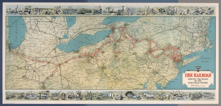
Author
[Whitney-Graham Company, Inc., Erie Railroad Company]
Full Title
Ship and travel by fast Erie Service. Erie Railroad serving the heart of industrial empire. (to accompany) The blue book of map making : America's map makers. R.W.C. The Whitney-Graham Co. Inc. (5 insets).
List No
11489.022
Note
Color map folded. Includes illustration of industry and agriculture on upper and lower panels. Map showing Erie Railroad and trackage rights over railroad in color. Also shows state boundaries, cities, towns and roads.
Author
Andreas, A. T. (Alfred Theodore), 1839-1900
Full Title
New railroad map of the United States, the Dominion of Canada, Mexico and the West Indies. (Published by the Andreas Atlas Co., Lakeside Building, Chicago, Ills. Engraved & printed by Chas. Shober & Co., Props. of Chicago Lithographing Co.)
List No
0018.012
Note
Hand col. lithographed map. Relief shown by hachures. Title includes view. Prime meridians: Washington and Greenwich.
Author
[Andreas, A. T. (Alfred Theodore), 1839-1900, Baskin, Forster and Company]
Full Title
New railroad map of the United States and Dominion of Canada. (Published by Baskin, Forster & Co. Lakeside Building Chicago, Ills. 1876. Engraved & Printed by Chas. Shober & Co. Props. of Chicago Lithographing Co.)
List No
0019.006
Note
Lithographed map. Hand col. Relief shown by hachures. Includes farm scene below title.
Author
Cram, George Franklin
Full Title
Railroad and County Map of New Jersey.
List No
0210.028
Note
Prime meridians Greenwich and Washington.
Author
Cram, George Franklin
Full Title
New Rail Road and County Map of Deleware (Delaware), Maryland, Virginia & West Virginia.
List No
0210.029
Note
Prime meridians Greenwich and Washington.
Author
Cram, George Franklin
Full Title
New Rail Road and Count Map of North Carolina.
List No
0210.030
Note
Prime meridians Greenwich and Washington.
Author
Cram, George Franklin
Full Title
New Rail Road and County Map of Alabama, Georgia, Sth. Carolina & Northern Florida.
List No
0210.031
Note
Prime meridians Greenwich and Washington.
Author
Cram, George Franklin
Full Title
New Rail Road and County Map of Kentucky & Tennessee.
List No
0210.032
Note
Prime meridians Greenwich and Washington.
Author
Cram, George Franklin
Full Title
New Rail Road and County Map of Missouri.
List No
0210.033
Note
Prime meridians Greenwich and Washington.
Author
Cram, George Franklin
Full Title
New Rail Road and County Map of Michigan & Wisconsin.
List No
0210.040
Note
Prime meridians Greenwich and Washington.
Author
[Gray, Frank A., Gray, O.W.]
Full Title
Gray's Atlas New Rail Road and County Map of the States of Oregon, California, and Nevada Compiled and Drawn by Frank A. Gray. Published by O.W. Gray, Phladelphia. (inset) Enlarged Plan of the Vicinity of San Francisco and Sacramento.
List No
0310.081
Author
Larousse
Full Title
France (Chemins de Fer).
List No
0418.081
Author
Lizars, William Home, 1788-1859
Full Title
England. Published by W.H. Lizars, Edinburgh. With all the railways. Samuel Highley, London & W. Curry junr. & Co, Dublin. (to accompany) Lizars' Edinburgh Geographical General Atlas ... 1841.
List No
0438.015
Note
1 map on 2 sheet, double page engraved hand colored in outline. Relief shown by hachures. Shows administrative boundaries, cities, roads, railroads, rivers and mountains. Prime meridian is Greenwich.
Author
Lizars, William Home, 1788-1859
Full Title
England. Published by W.H. Lizars, Edinburgh. With all the railways. Samuel Highley, London & W. Curry junr. & Co, Dublin. (to accompany) Lizars' Edinburgh Geographical General Atlas ... 1841.
List No
0438.016
Note
1 map on 2 sheet, double page engraved hand colored in outline. Relief shown by hachures. Shows administrative boundaries, cities, roads, railroads, rivers and mountains. Prime meridian is Greenwich.
Author
Lizars, William Home, 1788-1859
Full Title
Scotland : With all the railways. Published by W.H. Lizars, Edinburgh. Samuel Highley, London & W. Curry junr. & Co, Dublin. (to accompany) Lizars' Edinburgh Geographical General Atlas ... 1841. (inset) Shetland Isles.
List No
0438.018
Note
1 map on 2 sheet, double page engraved hand colored in outline. Relief shown by hachures. Shows administrative boundaries, cities, roads, railroads, rivers and mountains. Prime meridian is Greenwich.
Author
Lizars, William Home, 1788-1859
Full Title
Scotland : With all the railways. Published by W.H. Lizars, Edinburgh. Samuel Highley, London & W. Curry junr. & Co, Dublin. (to accompany) Lizars' Edinburgh Geographical General Atlas ... 1841. (inset) Shetland Isles.
List No
0438.019
Note
1 map on 2 sheet, double page engraved hand colored in outline. Relief shown by hachures. Shows administrative boundaries, cities, roads, railroads, rivers and mountains. Prime meridian is Greenwich.
Author
Lizars, William Home, 1788-1859
Full Title
Ireland : With all the railways. Published by W.H. Lizars, Edinburgh. Samuel Highley, London & W. Curry junr. & Co, Dublin. (to accompany) Lizars' Edinburgh Geographical General Atlas ... 1841.
List No
0438.021
Note
1 map on 2 sheet, double page engraved hand colored in outline. Relief shown by hachures. Shows administrative boundaries, cities, roads, railroads, rivers, canals and mountains.
Author
Lizars, William Home, 1788-1859
Full Title
Ireland : With all the railways. Published by W.H. Lizars, Edinburgh. Samuel Highley, London & W. Curry junr. & Co, Dublin. (to accompany) Lizars' Edinburgh Geographical General Atlas ... 1841.
List No
0438.022
Note
1 map on 2 sheet, double page engraved hand colored in outline. Relief shown by hachures. Shows administrative boundaries, cities, roads, railroads, rivers, canals and mountains.
Author
Lizars, William Home, 1788-1859
Full Title
France, in provinces. Published by W. Lizars, Edinburgh. (to accompany) Lizars' Edinburgh Geographical General Atlas ... 1841.
List No
0438.043
Note
Double page engraved hand colored in outline map. Color coded by provinces. Relief shown by hachures. Shows towns, roads, railroads, rivers, forests and mountains. Prime meridian is Greenwich.
Author
Lizars, William Home, 1788-1859
Full Title
France in departments. Published by W. Lizars, Edinburgh. (to accompany) Lizars' Edinburgh Geographical General Atlas ... 1841. (inset) Corsica.
List No
0438.044
Note
Double page engraved hand colored in outline map. Color coded by departments. Relief shown by hachures. Shows towns, roads, railroads, rivers, forests and mountains. Prime meridian is Greenwich. Includes note.
Author
Lizars, William Home, 1788-1859
Full Title
United States & Texas. With all the railways and canals. Published by W. Lizars, Edinburgh. (to accompany) Lizars' Edinburgh Geographical General Atlas ... 1841.
List No
0438.074
Note
Double page engraved hand colored in outline. Relief shown by hachures. Shows "Republic of Texas," the eastern United States and its western territories, Indian settlements, towns, roads, railroads, rivers, canals and mountains. Prime meridian is Greenwich.
Author
Mitchell, Samuel Augustus Jr.
Full Title
Railroad map of the United States, showing the through lines of communication from the Atlantic to the Pacific, together with the various steamship lines along the seaboard. Copyright by Wm. M. Bradley & Bro. 1884.
List No
0592.010
Note
Red printed colored lines. Relief shown by hachures. Shows settlements, rivers, named railroads and steamship lines, etc. Prime meridians: Greenwich and Washington.
Author
Mitchell, Samuel Augustus Jr.
Full Title
Map of Mexico, Central America, and the West Indies. (with) Map of the Bermuda Islands. (with) Map of the island of Jamaica. (with) Map of the proposed ship rail road route across the isthmus of Tehuantepec. (with) Map of the Panama Railroad and proposed canal. (with) Map of the proposed Nicaragua Canal route. Copyright by S. Augustus Mitchell 1884.
List No
0592.053
Note
Hand colored map with 5 insets. Relief shown by hachures. Shows states, settlements, railroads, rivers, etc. Prime meridians: Greenwich and Washington.
Full Title
Railroad map of the United States, showing the through lines of communication from the Atlantic to the Pacific, together with the various steamship lines along the seaboard. Copyright 1886 by Wm. M. Bradley & Bro. (1890)
List No
0594.009
Note
Colored map. Relief shown by hachures. Shows settlements, rivers, named railroads and steamship lines, etc. Prime meridians: Greenwich and Washington.
Full Title
Map of Mexico, Central America, and the West Indies. (with) Map of the Bermuda Islands. (with) Map of the island of Jamaica. (with) Map of the proposed ship rail road route across the isthmus of Tehuantepec. (with) Map of the Panama Railroad and proposed canal. (with) Map of the proposed Nicaragua Canal route. Copyright 1887 by Wm. M. Bradley & Bro. (1890)
List No
0594.051
Note
Hand colored map with 5 insets. Relief shown by hachures. Shows states, settlements, railroads, rivers, etc. Prime meridians: Greenwich and Washington.
Author
Society for the Diffusion of Useful Knowledge (Great Britain)
Full Title
England with its canals and railways. Published under the superintendence of the Society for the Diffusion of Useful Knowledge. London, published by Baldwin & Cradock, 47 Paternoster Row Octr. 1st. 1837. Engd. by J. & C. Walker. (London: Chapman and Hall, 1844)
List No
0890.013
Note
Engraved map. Canals, railroads and county boundaries hand col.
Author
Snyder, Van Vechten & Co.
Full Title
New rail road map of the United States. (Compiled and published by Snyder, Van Vechten & Co., Milwaukee. 1878)
List No
0936.010
Note
Hand col. lithographed map. Relief shown by hachures. Includes 2 small views.
Author
Stanford, Edward
Full Title
A Railway Map of the British Isles. (inset) Orkney and Shetland Islands.
List No
0949.021
Note
Full color. Includes inset of the Orkney and Shetland islands.
Author
J.H. Stuart & Co.
Full Title
Railroad map of Maine. (1894)
List No
0966.002
Note
Uncolored lithographed map. Shows named railroads, cities, counties, etc.
Author
[Martin, R.M., Tallis, J. & F.]
Full Title
Talis's Railway Map of Great Britain. Showing the Railways Completed, and the Stations on each line, up to the present time.
List No
10095.088
Author
[Touring club italiano, Funk & Wagnalls Company.]
Full Title
Linee di comunicazione del Oceano Atlantico. Propr. Artistico-letteraria del T.C.I. Ufficio cartografico del T.C.I. (1929)
List No
1012.003
Note
Color map.
Author
[Touring club italiano, Funk & Wagnalls Company.]
Full Title
Linee di comunicazione degli oceani Indiano e Pacifico. Propr. Artistico-letteraria del T.C.I. Ufficio cartografico del T.C.I. (1929)
List No
1012.004
Note
Color map.
Author
[Touring club italiano, Funk & Wagnalls Company.]
Full Title
Linee di comunicazione dell'Europa centrale e Mediterranea. Propr. Artistico-letteraria del T.C.I. Ufficio cartografico del T.C.I. (1929)
List No
1012.005
Note
Color map.
Author
شكوفه مقبل [Şukufe Mukbil]
Full Title
(Japan and Korea with railroads)
List No
10992.026
Note
Dimensions are sheet size.
Author
شكوفه مقبل [Şukufe Mukbil]
Full Title
(Tunisia with railroads)
List No
10992.030
Note
Dimensions are sheet size.
Author
شكوفه مقبل [Şukufe Mukbil]
Full Title
(Libya)
List No
10992.031
Note
Dimensions are sheet size.
Author
شكوفه مقبل [Şukufe Mukbil]
Full Title
(Egypt with railroads)
List No
10992.032
Note
Dimensions are sheet size.
Author
شكوفه مقبل [Şukufe Mukbil]
Full Title
(North and Central America with Railroads)
List No
10992.038
Note
Dimensions are sheet size.
Author
شكوفه مقبل [Şukufe Mukbil]
Full Title
(Rivers of South America)
List No
10992.039
Note
Dimensions are sheet size.
Author
شكوفه مقبل [Şukufe Mukbil]
Full Title
(United States with railroads)
List No
10992.041
Note
Dimensions are sheet size.
Author
شكوفه مقبل [Şukufe Mukbil]
Full Title
(South America with Railroads)
List No
10992.045
Note
Dimensions are sheet size. Has flag of Argentina on opposite page.
Author
شكوفه مقبل [Şukufe Mukbil]
Full Title
(Australia with neighboring islands and railroads)
List No
10992.049
Note
Dimensions are sheet size.
Author
[Gorkin, Aleksandr Fedorovich, Motylev, V.E.]
Full Title
Zheleznodorozhnye i vodnye puti soobshcheniia Evropeyskoi chasti Soiuza SSR. (inset) Etapy zheleznodorozhnogo stroitelstva do revolyutsii. (to accompany) Bolshoi Sovietskii Atlas Mira. Moskva 1937.
List No
11008.172
Note
Color map of rail and water communications in European Russia on 2 sheets. Shows road, railroads, water ways, etc. Inset shown stages of railway construction before the revolution. Include explanation to symbols, chart and graphs.
Author
Walling, H. F.
Full Title
Map of the State of Michigan showing counties, townships, rail roads, stations, etc. (Drawn, compiled, and edited by H.F. Walling, C.E. ... Published by R.M. & S.T. Tackabury, Detroit, Mich. Entered ... 1873, by H.F. Walling ... Washington. The Claremont Manufacturing Company, Claremont, N.H., Book Manufacturers)
List No
1147.002
Note
Hand col. lithographed map. Counties shown in full color.
|