|
REFINE
Browse All : Pocket Map from 1882
1-37 of 37
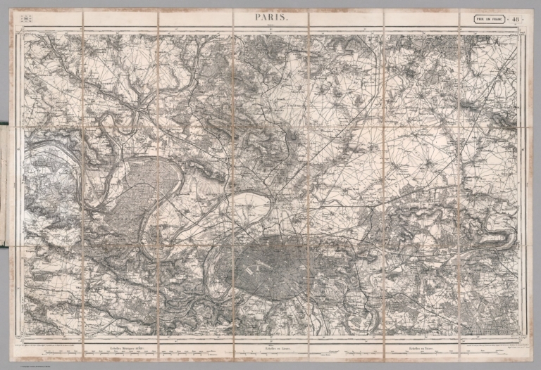
France. Service géographique de l'armé... Paris. 48. (Carte de France Etat Major 8... 1882 10191.003 Related Author
[France. Service géographique de l'armée, Depot De La Guerre (France)]
Full Title
Paris. 48. (Carte de France Etat Major 80,000). Levée par les officiers du Corps d'Etat-Major et publiée par le Dépôt général de la guerre en 1832.
List No
10191.003
Note
Date estimated based on railroad construction. This is sheet 48 of the 258 sheet Carte de France de l'Etat-Major, completed in 1832 as a replacement for the 182 sheet Cassini Survey. All sheets were updated through the early 20th century. Folded into green covers with attached map of France showing the assembly of all 258 sheets.
Author
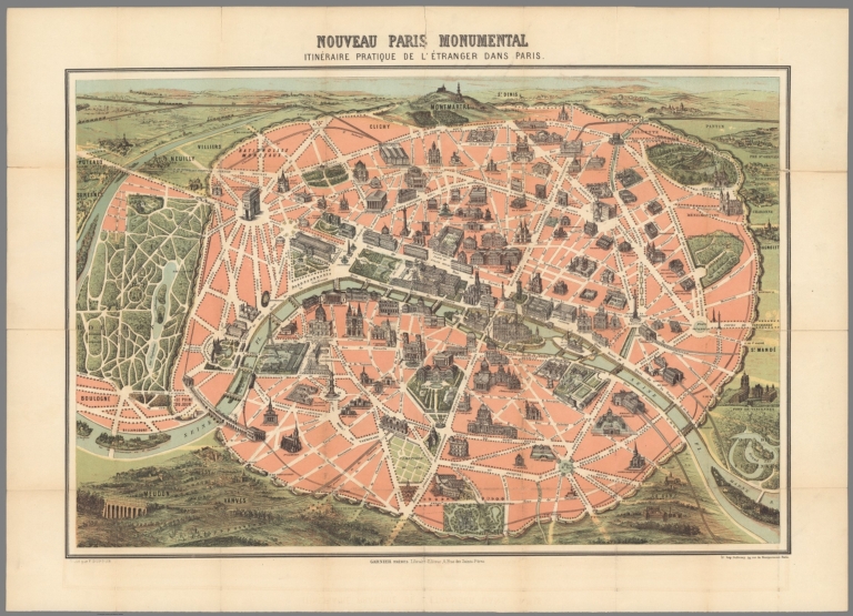
Garnier frères
Full Title
Nouveau Paris monumental. Itinéraire pratique de l'étranger dans Paris.
List No
10187.001
Note
Show important buildings and monuments of Paris in isometric view.
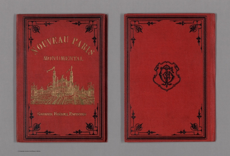
Author
Garnier frères
Full Title
(Covers to) Nouveau Paris monumental. Itinéraire pratique de l'étranger dans Paris.
List No
10187.002
Note
Show important buildings and monuments of Paris in isometric view.
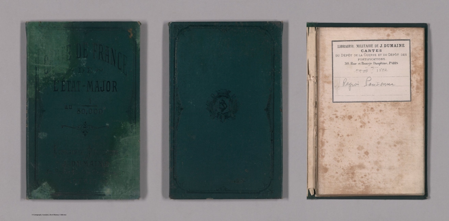
France. Service géographique de l'armé... Covers: Paris. 48. (Carte de France Etat... 1882 10191.001 Related Author
[France. Service géographique de l'armée, Depot De La Guerre (France)]
Full Title
(Covers to) Paris. 48. (Carte de France Etat Major 80,000). Levée par les officiers du Corps d'Etat-Major et publiée par le Dépôt général de la guerre en 1832.
List No
10191.001
Note
Date estimated based on railroad construction. This is sheet 48 of the 258 sheet Carte de France de l'Etat-Major, completed in 1832 as a replacement for the 182 sheet Cassini Survey. All sheets were updated through the early 20th century. Folded into green covers with attached map of France showing the assembly of all 258 sheets.
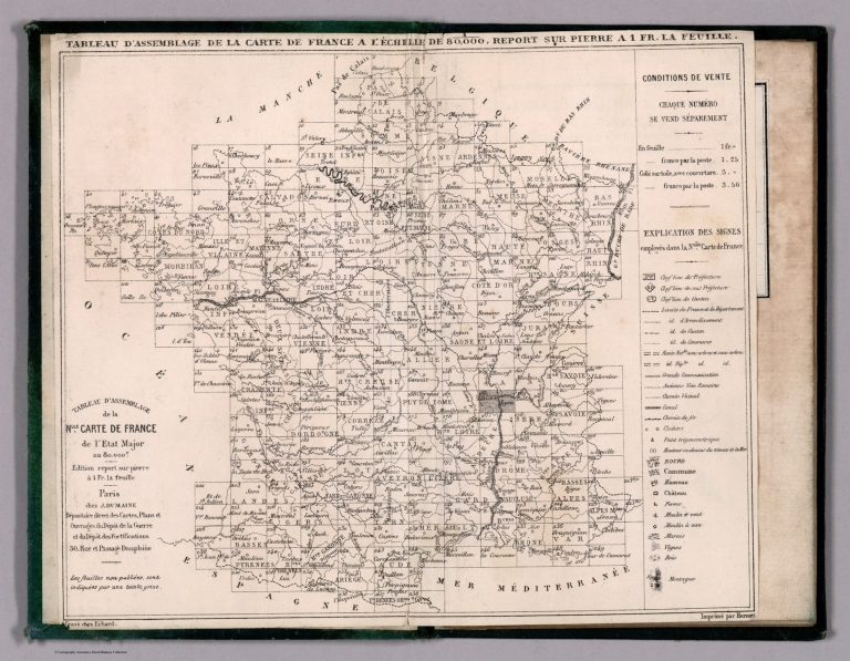
France. Service géographique de l'armé... Tableau D'Assemblage De La Carte De Fran... 1882 10191.002 Related Author
[France. Service géographique de l'armée, Depot De La Guerre (France)]
Full Title
Tableau D'Assemblage De La Carte De France
List No
10191.002
Note
A small map inside the covers which shows the assembly of the 258 sheets and the signs and symbols used in the map. Date estimated based on railroad construction. This is sheet 48 of the 258 sheet Carte de France de l'Etat-Major, completed in 1832 as a replacement for the 182 sheet Cassini Survey. All sheets were updated through the early 20th century. Folded into green covers with attached map of France showing the assembly of all 258 sheets.
Author
G.W. & C.B. Colton & Co.
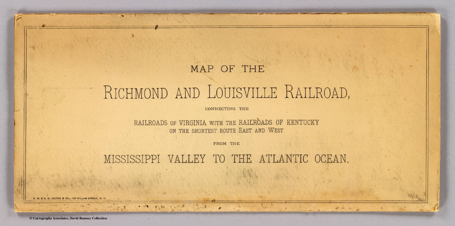
Full Title
(Covers to) Map of the Richmond and Louisville R.R. connecting the railroads of Virginia with the railroads of Kentucky on the shortest route east and west from the Mississippi Valley to the Atlantic Ocean. Engraved, printed and manufactured by G.W. & C.B. Colton & Co. No. 182 William St. New York. Entered ... 1882 by G.W. & C.B. Colton & Co. ... at Washington.
List No
1702A
Note
Heavy beige paper covers printed with the title: Map of the Richmond and Louisville Railroad, connecting the railroads of Virginia with the railroads of Kentucky on the shortest route east and west from the Mississippi Valley to the Atlantic Ocean.
Author
G.W. & C.B. Colton & Co.
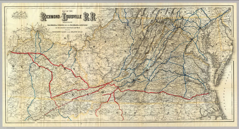
Full Title
Map of the Richmond and Louisville R.R. connecting the railroads of Virginia with the railroads of Kentucky on the shortest route east and west from the Mississippi Valley to the Atlantic Ocean. Engraved, printed and manufactured by G.W. & C.B. Colton & Co. No. 182 William St. New York. Entered ... 1882 by G.W. & C.B. Colton & Co. ... at Washington.
List No
1702.001
Note
Relief shown by hachures. Outline color by state with railroads colored in red and blue.
Author
Smith, J.L.
Full Title
(Covers to) Driving Map of Philadelphia and Vicinity. Published by J.L. Smith, 27 South Sixth St. Phila., Pa. 1882. Entered ... 1882 by J.L. Smith ... Washington.
List No
2459.001
Note
J.L. Smith succeeded to R.L. Barnes' map business. J.L. Smith was a map publisher in Philadelphia in the 1870-1890 period. He is not listed in Ristow, other than as a publisher of Martinet's Maryland map in its later editions. Folded into brown cloth covers 15.5x10.5 with "Smith's Map of Philadelphia And Vicinity" stamped in gilt.
Author
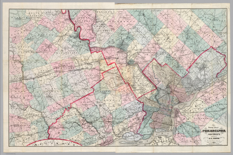
Smith, J.L.
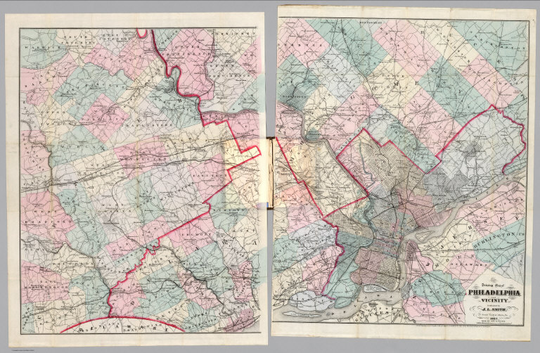
Full Title
Driving Map of Philadelphia and Vicinity. Published by J.L. Smith, 27 South Sixth St. Phila., Pa. 1882. Entered ... 1882 by J.L. Smith ... Washington.
List No
2459.002
Note
J.L. Smith succeeded to R.L. Barnes' map business. J.L. Smith was a map publisher in Philadelphia in the 1870-1890 period. He is not listed in Ristow, other than as a publisher of Martinet's Maryland map in its later editions. Folded into brown cloth covers 15.5x10.5 with "Smith's Map of Philadelphia And Vicinity" stamped in gilt.
Author
Smith, J.L.
Full Title
(Composite of) Driving Map of Philadelphia and Vicinity. Published by J.L. Smith, 27 South Sixth St. Phila., Pa. 1882. Entered ... 1882 by J.L. Smith ... Washington.
List No
2459.003
Note
Full color map. Folded into brown cloth covers 15.5x10.5 with "Smith's Map of Philadelphia And Vicinity" stamped in gilt.
Author
Colton, G.W. & C.B.
Full Title
(Covers to) Map Of The Country Thirty Three Miles Around The City Of New York. Published By G.W. And C.B. Colton, & Co., 182 William St. New York. Entered ... 1846, by J.H. Colton ... New York. 1882.
List No
2476.001
Note
Still more railroads are added, compared to the 1876 edition. An unknown "L.A. Roberts" is listed as the Colton's partner on the inside cover paste down ad. Folded into dark brown cloth covers 14.5x9 with "Colton's Map Of The Country Thirty Three Miles Around The City Of New-York G.W. & C.B. Colton & Co" in gilt. Full color. Prime meridians are Greenwich and Washington D.C. Relief shown by hachures, depth shown by isolines and soundings.
Author
Colton, G.W. & C.B.
Full Title
Map Of The Country Thirty Three Miles Around The City Of New York. Published By G.W. And C.B. Colton, & Co., 182 William St. New York. Entered ... 1846, by J.H. Colton ... New York. 1882.
List No
2476.002
Note
Still more railroads are added, compared to the 1876 edition. An unknown "L.A. Roberts" is listed as the Colton's partner on the inside cover paste down ad. Folded into dark brown cloth covers 14.5x9 with "Colton's Map Of The Country Thirty Three Miles Around The City Of New-York G.W. & C.B. Colton & Co" in gilt. Full color. Prime meridians are Greenwich and Washington D.C. Relief shown by hachures, depth shown by isolines and soundings.
Author
Rice, G. Jay.
Full Title
(Covers to) Rice's New Sectional Map of the State of Minnesota. 1882. Published By St. Paul Lithographing & Publishing Co. St. Paul, Minn. Oct. Edition 1882. Copyright 1880 by G. Jay Rice. (inset) Map Of St. Paul, Minneapolis & Vicinity.
List No
3416.001
Note
1st edition 1880. "Oct. edition 1882" below the title. The state is still undeveloped in the north. See Rice's Dakota maps. Full color by county and folded into brown cloth covers 14.5x9.5 stamped with "Rice's Sectional Map Of Minnesota" in gilt.
Author
Rice, G. Jay.
Full Title
Rice's New Sectional Map of the State of Minnesota. 1882. Published By St. Paul Lithographing & Publishing Co. St. Paul, Minn. Oct. Edition 1882. Copyright 1880 by G. Jay Rice. (inset) Map Of St. Paul, Minneapolis & Vicinity.
List No
3416.002
Note
1st edition 1880. "Oct. edition 1882" below the title. The state is still undeveloped in the north. See Rice's Dakota maps. Full color by county and folded into brown cloth covers 14.5x9.5 stamped with "Rice's Sectional Map Of Minnesota" in gilt.
Author
Page, H.R. & Co.
Full Title
(Covers to) Map Of Michigan Compiled from the latest Authentic Sources. Published by H.R. Page & Co. Chicago, Ill. 1882. (with 2 inset maps).
List No
4053.001
Note
Karrow shows editions of 1879, 1880, and 1884, but not this 1882 edition. Large map of the state with inset maps of Isle Royale and the western upper peninsula. With Index "Guide to Michigan". Publisher's advertisement on inside front cover. Folded into textured dark brown cloth covers 15x10 with "Sectional Michigan H.R. Page & Co. Chicago" in gilt.
Author
Page, H.R. & Co.
Full Title
Map Of Michigan Compiled from the latest Authentic Sources. Published by H.R. Page & Co. Chicago, Ill. 1882. (with 2 inset maps).
List No
4053.002
Note
Karrow shows editions of 1879, 1880, and 1884, but not this 1882 edition. Large color map of the state with inset maps of Isle Royale and the western upper peninsula. Index. Folded into textured dark brown cloth covers 15x10 with "Sectional Michigan H.R. Page & Co. Chicago" in gilt.
Author
Thayer, H.L.
Full Title
(Covers to) Thayer's Map Of New Mexico. Published By H.L. Thayer, Denver, Col. From Surveys of the General Land Office, used by permission, revised & corrected to date by the Publisher. Photo lith & print by Julius Bien & Co. 16 & 18 Park Place N.Y.
List No
4335.001
Note
This is from the same plate used by Bien for the General Land Office "Map of The Territory of New Mexico" first issued in 1879. Comparing this with the 1882 GLO edition we can find absolutely no changes, notwithstanding Thayer's claims in the title. The only difference is the use of hand color by Thayer versus printed color by the GLO. Undated, with the date estimated by comparison with the GLO map of 1882. The Streeter copy is dated 1880. Scarce. Map is folded into dark green cloth covers 15x10 with "Thayer's Map Of New Mexico. One Dollar." stamped in gilt.
Author
Thayer, H.L.
Full Title
Thayer's Map Of New Mexico. Published By H.L. Thayer, Denver, Col. From Surveys of the General Land Office, used by permission, revised & corrected to date by the Publisher. Photo lith & print by Julius Bien & Co. 16 & 18 Park Place N.Y.
List No
4335.002
Note
This is from the same plate used by Bien for the General Land Office "Map of The Territory of New Mexico" first issued in 1879. Comparing this with the 1882 GLO edition we can find absolutely no changes, notwithstanding Thayer's claims in the title. The only difference is the use of hand color by Thayer versus printed color by the GLO. Undated, with the date estimated by comparison with the GLO map of 1882. The Streeter copy is dated 1880. Scarce. Map is folded into dark green cloth covers 15x10 with "Thayer's Map Of New Mexico. One Dollar." stamped in gilt.
Author
[Page, H.R. & Co., Brewster, Charles]
Full Title
(Covers to) Map of Nebraska. Compiled from Official Records in the Surveyor General's Office And Other Authentic Sources By Charles Brewster C.E. Published by H.R. Page & Co. Chicago, Ill. 1882. Copyright 1879 by H.R. Page & Co.
List No
4421.001
Note
First edition was 1879. Large impressive sectional map of the State in two separate sheets. Two huge counties, Sioux and Cheyenne, cover the westernmost portion of the state at the Wyoming border. Another unnamed county dominates the upper middle section. The sectional surveys are completed throughout, except for the northwest corner. There was an earlier edition in 1880. Full color. Folded in textured black cloth covers 17x11 with "Sectional Map Of Nebraska H.R. Page & Co. Chicago." stamped in gold.
Author
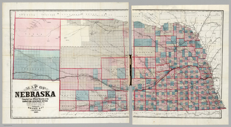
[Page, H.R. & Co., Brewster, Charles]
Full Title
Map of Nebraska. Compiled from Official Records in the Surveyor General's Office And Other Authentic Sources By Charles Brewster C.E. Published by H.R. Page & Co. Chicago, Ill. 1882. Copyright 1879 by H.R. Page & Co.
List No
4421.002
Note
First edition was 1879. Large impressive sectional map of the State in two separate sheets. Two huge counties, Sioux and Cheyenne, cover the westernmost portion of the state at the Wyoming border. Another unnamed county dominates the upper middle section. The sectional surveys are completed throughout, except for the northwest corner. There was an earlier edition in 1880. Full color. Folded in textured black cloth covers 17x11 with "Sectional Map Of Nebraska H.R. Page & Co. Chicago." stamped in gold.
Author
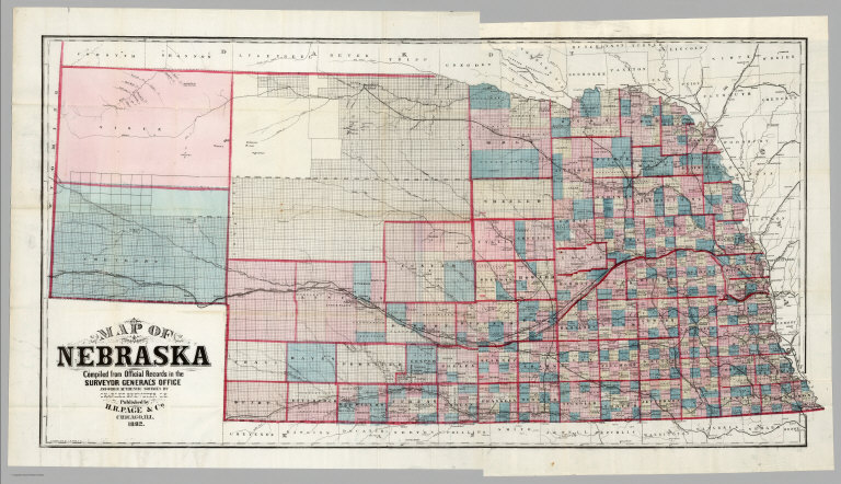
[Page, H.R. & Co., Brewster, Charles]
Full Title
(Composite of) Map of Nebraska. Compiled from Official Records in the Surveyor General's Office And Other Authentic Sources By Charles Brewster C.E. Published by H.R. Page & Co. Chicago, Ill. 1882. Copyright 1879 by H.R. Page & Co.
List No
4421.003
Note
First edition was 1879. Large impressive sectional map of the State in two separate sheets. Two huge counties, Sioux and Cheyenne, cover the westernmost portion of the state at the Wyoming border. Another unnamed county dominates the upper middle section. The sectional surveys are completed throughout, except for the northwest corner. There was an earlier edition in 1880. Full color. Folded in textured black cloth covers 17x11 with "Sectional Map Of Nebraska H.R. Page & Co. Chicago." stamped in gold.
Author
Rand McNally and Company
Full Title
(Covers to) Rand McNally & Co.'s Dakota. Copyright, 1882, by Rand, McNally & Co., Map Publishers, Chicago, Ill. Rand, McNally & Co., Engr's. Chicago. (with 15 page index) Rand McNally & Co.'s Indexed County And Township Map Of Dakota... Chicago, U.S.A.: Rand, McNally & Co. ... (on verso) Entered ... 1882, by Rand, McNally & Co. ... Washington.
List No
4502.001
Note
A large and very early Rand McNally map of Dakota that does not appear in the Indexed Atlas of 1881 or 1882. Another version was published for the Chicago, Milwaukee & St. Paul Railway Co. in 1882 (see our copy). Folded into tan card board covers 17x11 printed with same title as index. Prime meridians are Greenwich and Washington D.C. Relief shown by hachures.
Author
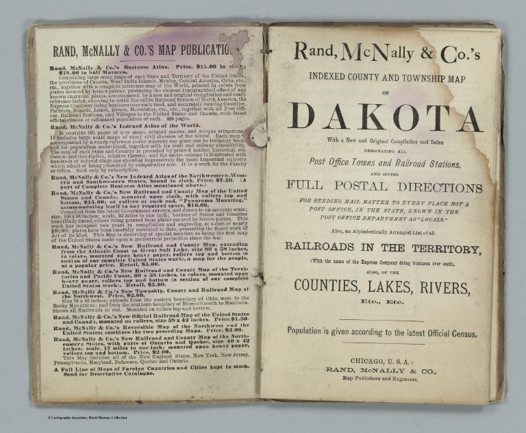
Rand McNally and Company
Full Title
(Title page to) Rand McNally & Co.'s Dakota. Copyright, 1882, by Rand, McNally & Co., Map Publishers, Chicago, Ill. Rand, McNally & Co., Engr's. Chicago. (with 15 page index) Rand McNally & Co.'s Indexed County And Township Map Of Dakota... Chicago, U.S.A.: Rand, McNally & Co. ... (on verso) Entered ... 1882, by Rand, McNally & Co. ... Washington.
List No
4502.002
Note
A large and very early Rand McNally map of Dakota that does not appear in the Indexed Atlas of 1881 or 1882. Another version was published for the Chicago, Milwaukee & St. Paul Railway Co. in 1882 (see our copy). Folded into tan card board covers 17x11 printed with same title as index. Prime meridians are Greenwich and Washington D.C. Relief shown by hachures.
Author
Rand McNally and Company
Full Title
Rand McNally & Co.'s Dakota. Copyright, 1882, by Rand, McNally & Co., Map Publishers, Chicago, Ill. Rand, McNally & Co., Engr's. Chicago. (with 15 page index) Rand McNally & Co.'s Indexed County And Township Map Of Dakota... Chicago, U.S.A.: Rand, McNally & Co. ... (on verso) Entered ... 1882, by Rand, McNally & Co. ... Washington.
List No
4502.003
Note
A large and very early Rand McNally map of Dakota that does not appear in the Indexed Atlas of 1881 or 1882. Another version was published for the Chicago, Milwaukee & St. Paul Railway Co. in 1882 (see our copy). Folded into tan card board covers 17x11 printed with same title as index. Prime meridians are Greenwich and Washington D.C. Relief shown by hachures.
Author
Rand McNally and Company
Full Title
(Covers to) Rand McNally & Co.'s New Enlarged Scale Railroad And County Map Of Texas, Showing Every Railroad Station And Post Office In The State. Copyright, 1882, By Rand, McNally & Co., Chicago, Ill. (inset) N.W. Corner & Pan-Handle. (untitled inset map of El Paso). (with 49 page index) Rand, McNally & Co.'s Indexed County And Township Map Of Texas ... Chicago, U.S.A.: Rand, McNally & Co., Map Publishers and Engravers. (on verso) Entered ... 1882, by Rand, McNally & Co. ... Washington.
List No
4749A
Author
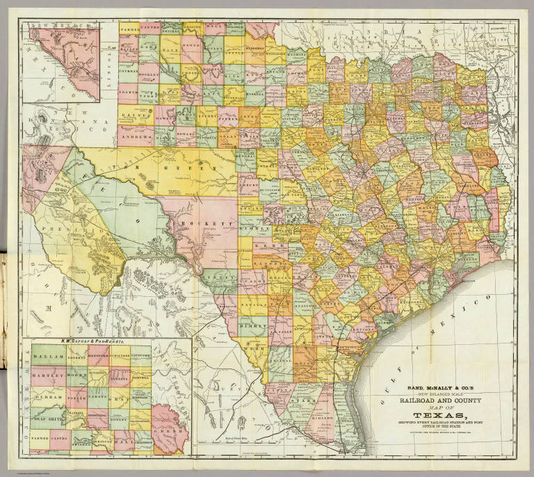
Rand McNally and Company
Full Title
Rand McNally & Co.'s New Enlarged Scale Railroad And County Map Of Texas, Showing Every Railroad Station And Post Office In The State. Copyright, 1882, By Rand, McNally & Co., Chicago, Ill. (inset) N.W. Corner & Pan-Handle. (untitled inset map of El Paso). (with 49 page index) Rand, McNally & Co.'s Indexed County And Township Map Of Texas ... Chicago, U.S.A.: Rand, McNally & Co., Map Publishers and Engravers. (on verso) Entered ... 1882, by Rand, McNally & Co. ... Washington.
List No
4749.001
Note
The first edition of an important railroad map of Texas, with the accompanying 49 page index. Full printed color by county. Covers are a dark green cloth measuring 17.5x11 with "Rand, McNally & Co's New Enlarged Scale Indexed Railroad And County Map Of Texas." stamped in gilt.
Author
[Kerr, W.C., Guyot, Arnold]
Full Title
(Covers to) Map Of North Carolina, By W.C. Kerr, State Geologist; Assisted by Capt. Wm. Cain, C.E. Published Under The Authority Of The State Board Of Agriculture. 1882. Constructed From Original Surveys And Triangulations Of The U.S. Coast And Geodetic Survey, Of Prof. Guyot, Of The State Geologist, And Of the U.S. Engineers; And Embodying The Surveys Made By The State From 1820 To Date ... Julius Bien & Co. Lith. N.Y. Entered ... 1882, by W.C. Kerr ... Washington.
List No
4854.001
Note
This is a large scale map of the state, beautifully executed with the mountains in printed color and the counties hand colored. It was probably backed financially by the state and is inscribed to Governor Thomas J. Jarvis. Below the title is the following: "The Map of a large part of the Mountain region was plotted to scale, from his own Triangulations, and furnished to hand, by Prof. Guyot, of Princeton." With a listing of Railroads, Towns with populations over 500, and Notes on state statistics. Folded into brown cloth covers 18.5x11 with "State Map Of North Carolina." in gilt.
Author
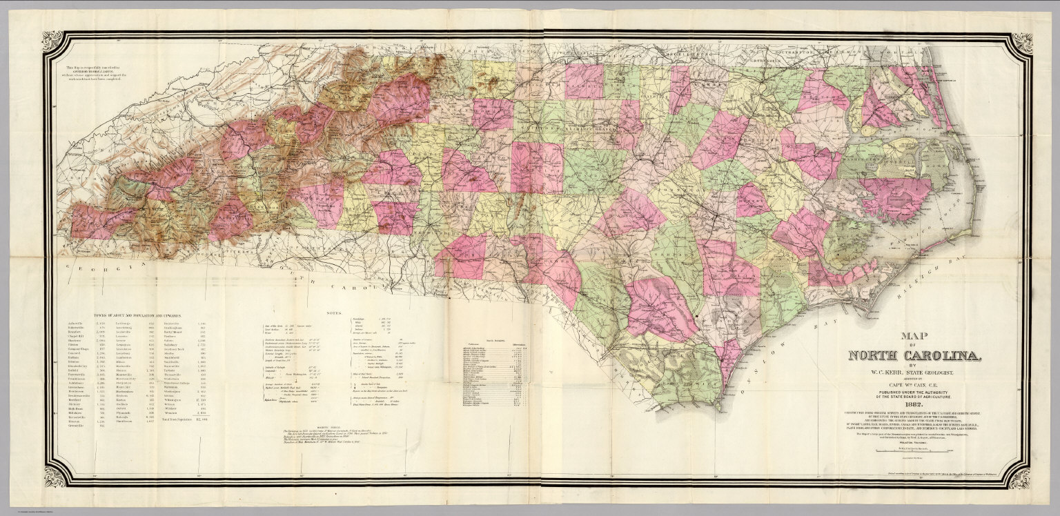
[Kerr, W.C., Guyot, Arnold]
Full Title
Map Of North Carolina, By W.C. Kerr, State Geologist; Assisted by Capt. Wm. Cain, C.E. Published Under The Authority Of The State Board Of Agriculture. 1882. Constructed From Original Surveys And Triangulations Of The U.S. Coast And Geodetic Survey, Of Prof. Guyot, Of The State Geologist, And Of the U.S. Engineers; And Embodying The Surveys Made By The State From 1820 To Date ... Julius Bien & Co. Lith. N.Y. Entered ... 1882, by W.C. Kerr ... Washington.
List No
4854.002
Note
This is a large scale map of the state, beautifully executed with the mountains in printed color and the counties hand colored. It was probably backed financially by the state and is inscribed to Governor Thomas J. Jarvis. Below the title is the following: "The Map of a large part of the Mountain region was plotted to scale, from his own Triangulations, and furnished to hand, by Prof. Guyot, of Princeton." With a listing of Railroads, Towns with populations over 500, and Notes on state statistics. Folded into brown cloth covers 18.5x11 with "State Map Of North Carolina." in gilt.
Author
Cram, George Franklin
Full Title
(Covers to) Pennsylvania. Geo. F. Cram, Engraver and Publisher, Chicago. Copyrighted 1882.
List No
4900.001
Note
With 85 page Index to Cram's Map of Pennsylvania, including a separate index of 67 railroads. This map predates, but is in the same form as, the Standard American Atlas maps of 1887 (our earliest issue). The Pennsylvania map in that atlas lists 76 railroads. Folded into black cloth covers 15x10 with "Indexed Railroad And County Map Of Pennsylvania Published By Geo. F. Cram Chicago" in gilt, which is worn off on this copy. Printed color. Prime meridians are Greenwich and Washington D.C.
Author
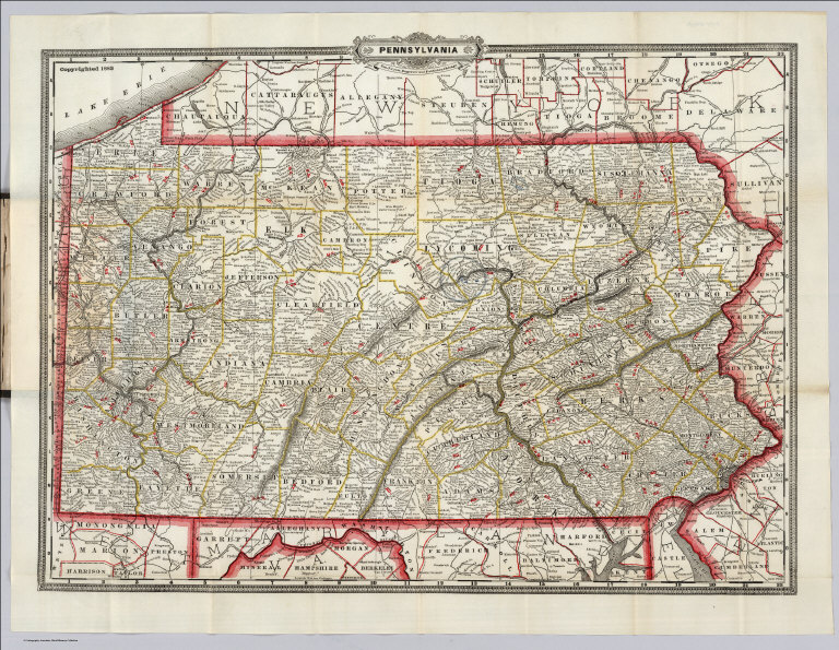
Cram, George Franklin
Full Title
Pennsylvania. Geo. F. Cram, Engraver and Publisher, Chicago. Copyrighted 1882.
List No
4900.002
Note
With 85 page Index to Cram's Map of Pennsylvania, including a separate index of 67 railroads. This map predates, but is in the same form as, the Standard American Atlas maps of 1887 (our earliest issue). The Pennsylvania map in that atlas lists 76 railroads. Folded into black cloth covers 15x10 with "Indexed Railroad And County Map Of Pennsylvania Published By Geo. F. Cram Chicago" in gilt, which is worn off on this copy. Printed color. Prime meridians are Greenwich and Washington D.C.
Author
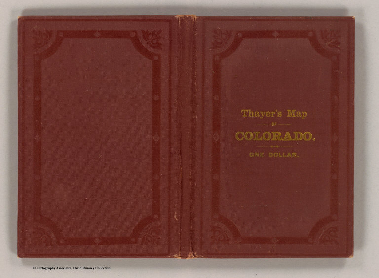
[Thayer, H. L., U.S. General Land Office]
Full Title
(Covers to) Thayer's map of Colorado. Published by H.L. Thayer, Denver, Col. 1882. Note. From surveys of the General Land Office, used by permission, revised & corrected to date by the publisher. Photo lith. & print. by Julius Bien & Co., 16 & 18 Park Place, N.Y.
List No
5203A
Note
Embossed brown cloth covers 15x10 with title stamped in gilt "Thayer's Map Of Colorado. One Dollar."
Author
[Thayer, H. L., U.S. General Land Office]
Full Title
(Inside covers to) Thayer's map of Colorado. Published by H.L. Thayer, Denver, Col. 1882. Note. From surveys of the General Land Office, used by permission, revised & corrected to date by the publisher. Photo lith. & print. by Julius Bien & Co., 16 & 18 Park Place, N.Y.
List No
5203B
Note
Inside front cover. Ads for Thayer's maps on the inside front cover, including the large GLO U.S. map ("the best United States map ever offered to the public")
Author
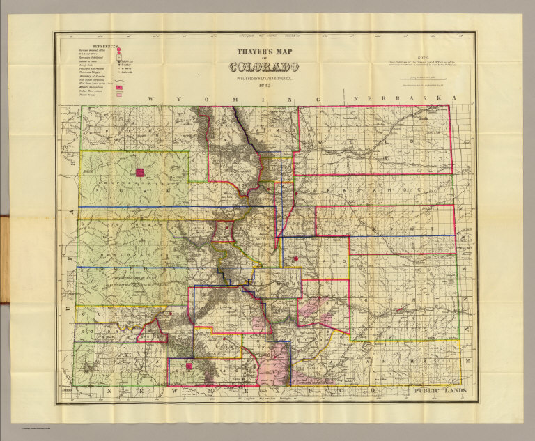
[Thayer, H. L., U.S. General Land Office]
Full Title
Thayer's map of Colorado. Published by H.L. Thayer, Denver, Col. 1882. Note. From surveys of the General Land Office, used by permission, revised & corrected to date by the publisher. Photo lith. & print. by Julius Bien & Co., 16 & 18 Park Place, N.Y.
List No
5203.001
Note
This is a restrike of the 1881 GLO Map of Colorado, hand colored in outline, with some additions, particularly the showing of the large land office districts (Leadville, Central City, Pueblo, Denver, Lake City, and Del Norte). In embossed brown cloth covers 15x10 with title stamped in gilt "Thayer's Map Of Colorado. One Dollar." Ads for Thayer's maps on the inside front cover, including the large GLO U.S. map ("the best United States map ever offered to the public") Relief shown by hachures. Shows counties, settlements, Indian reservations, Military reservations, private grants, railroad land grants, railroads, U.S. Public Land Survey System townships, etc. Prime meridians: Greenwich and Washington.
Author
Mills & Co.
Full Title
(Covers to) Mills & Co.'s New Railroad Post Office And Sectional Map Of Iowa Published by Mills & Co. Des Moines Iowa 1882.
List No
5404.001
Note
Enclosed in a green cloth case 17x12 with "Mills and Co's. New Railroad, Post-Office and Sectional Map Of Iowa 1882" embossed in gold. Bound with a Post-Office Index, Populations of Towns list and Population of Counties list as per the 1880 census. Full printed color.
Author
Mills & Co.
Full Title
(Title page to) Mills & Co.'s New Railroad Post Office And Sectional Map Of Iowa Published by Mills & Co. Des Moines Iowa 1882.
List No
5404.002
Note
Enclosed in a green cloth case 17x12 with "Mills and Co's. New Railroad, Post-Office and Sectional Map Of Iowa 1882" embossed in gold. Bound with a Post-Office Index, Populations of Towns list and Population of Counties list as per the 1880 census. Full printed color.
Author
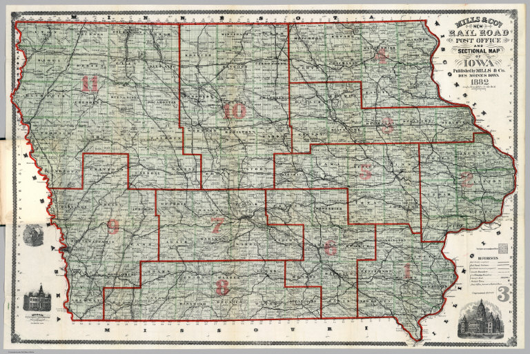
Mills & Co.
Full Title
Mills & Co.'s New Railroad Post Office And Sectional Map Of Iowa Published by Mills & Co. Des Moines Iowa 1882.
List No
5404.003
Note
Enclosed in a green cloth case 17x12 with "Mills and Co's. New Railroad, Post-Office and Sectional Map Of Iowa 1882" embossed in gold. Bound with a Post-Office Index, Populations of Towns list and Population of Counties list as per the 1880 census. Full printed color.
Author
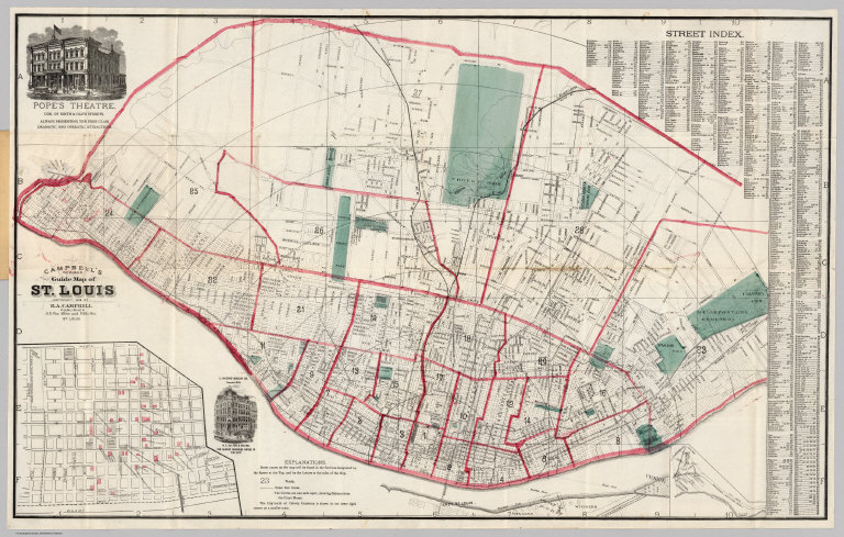
Campbell, R.A.
Full Title
Campbell's Revised Guide Map of St. Louis Copyright 1882 by R.A. Campbell Publisher S.E. Cor. Olive and Fifth Sts. St. Louis. (with inset map of the City north of Calvery Cemetery)
List No
5421.002
Note
Outline color highlighting each ward with parks in green. Street index included on map which folds into a 16x10 cardboard cover entitled "Campbell's Revised Guide-Map Of St. Louis Showing Boundaries, Streets, Wards, Street Railways, Parks, Etc., Etc. With Street Directory. Published For Planter's House, News and Cigar Stand. St. Louis. Copyright, 1882, By R. A. Campbell."
1-37 of 37
|