|
REFINE
Browse All : Pictorial map of Florida
1-28 of 28
Author
Wagner
Full Title
Welcome to Miller Time In Florida.
List No
15533.000
Author
[Fisher, Joseph R., Planters Peanuts (Firm)]
Full Title
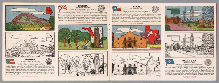
Georgia : The empire state of the south -- Florida : The peninsula state -- Texas : The lone star state -- Oklahoma : The sooner state.
List No
14374.007
Note
Four views, representing Georgia, Florida, Texas and Oklahoma. Views show examples of the landscape and natural resources. Each view includes an inset map of the state, which marks the location of the capital city with a star. Accompanied by descriptive text, the state flags, seals and flowers: Cherokee rose, orange blossom, bluebonnet and mistletoe, respectively. The view of each state appears both in color (on top) and in black and white (bottom), the latter inviting coloration. Together, views are 18 x 52 cm, on two sheets 20 x 54 cm.
Author
[Foster, Eleanore, Foster, Richard]
Full Title
A Map of Florida. Drawn by Eleanore and Richard Foster. Litho by Geo. C. Miller.
List No
10558.000
Author
Emery, Don J.
Full Title
A map of Florida for garden lovers. Published by the Garden Club of the Halifax Country Daytona Beach, Ormand & Ormand Beach. Copyright 1934. Designed by Don J. Emery- Daytona Beach.
List No
13212.002
Note
Pictorial map, bordered with decorative Art Deco illustrations of plants and bird species indigenous to Florida. Shows rich variety of flora, gardens, bird refuges, state parks, national forests, etc. Includes note describing the map, state and Garden Club seals. On verso: Text describing places of interest to lovers of both wild and cultivated gardens.
Author
Tripp, B. Ashburton, 1887-1955
Full Title
Poinciana Island. Tropical Florida Development Corp'n. Owners and Developers. Fowler - Rood Co. inc. Sales Agents. 253 West Flagler Street, Miami Florida. B. Ashburton Tripp Landscape Architect and Town Planner, Cleveland. Scale: 1" = 100' December, 1825.
List No
8648.000
Note
Poinciana was a speculative real estate development on the Gulf Coast of Florida across the peninsula from Miami. Tripp created this town plan late in 1925, but the hurricane of 1926 wiped out Poinciana Island which was located at the mouth of Lostman River, now part of the Everglades National Park. This plan was included in the 1926 May Show at the Cleveland Museum of Art.
Author
Arbuckle Bros.
Full Title
Florida, Virginia, Indiana, Rhode Island. Copyright 1889 Arbuckle Bros. N.Y.
List No
0027.004
Note
Sheet with maps of four states in full color. Florida is noted for its oranges and Rhode Island (called "Little Rhody") for its sewing thread. Each card measures 7.5 x 12.5 cm.
Author
Mink, David
Full Title
A Pictorial Chart of Romantic Florida depicting its exotic wild life; its tropical splendors of lands and sea; its historic past; its vital and exciting present. 1951.
List No
10512.000
Author
[Hamlin, P., Greyhound Corporation]
Full Title
Greyhound's fun map of the sunshine zone. P.H. (inset) Map of the Greyhound routes to Florida and Gulf Coast.
List No
11361.000
Note
Color pictorial map, showing the fun activities of Florida and the Gulf Coast, with humorous notes and images throughout the map, including Mardi Gras at New Orleans, horse racing outside Miami and a man in large sombrero smoking an oversized cigar in Key West. Showing major cities and places of interest. Text: "Includes list of all places you want to visit on your trip to and from the south ..." Inset map shows Greyhound routes to Florida and Gulf Cost, other Greyhound routes and connecting bus lines. Includes The Greyhound Lines logo, decorative cartouche and compass rose
Author
Swenningsen, Jack
Full Title
A United States map as the Floridian sees it. Map copyrighted 1948 by Gibin & Boeri ... Published by Florida Novelty Map and Stamp Company, St. Petersburg, Florida.
List No
11406.000
Note
Pictorial or cartoon map showing the adventures across the United States, with illustrations and descriptive notes, giving a detailed depiction of Florida it's relative size to the rest of the United States, showing California as "Gobi Desert", the rest of the United States as "Unexplored territory". Map is filled with illustrations including Yankee Stadium, World Capital, Paradise land and Niagara Falls. Shows images of landmarks, local people and people in various recreational activities. JS (Jack Swenningsen) initials in the lower right. Me-Hi-Co (Mexico) in the lower left. Includes decorative compass rose and note: "Adapted from Florida's Youthful Scene Magazine."
Author
Covarrubias, Miguel (1904-1957)
Full Title
Florida by Covarrubias. This road map painted specially for LIFE by Miguel Covarrubias ...
List No
11491.000
Note
Colored pictorial map of Florida Issued just after the WWII. Date estimated. Includes compass rose and descriptive text : "this road map, painted for LIFE by Miguel Covarrubias, takes the tourist along the main highways through the garish and exciting wonderland of the state of Florida." Depicts the diversity of natural resources, agricultural products and cultures. Shows industry, ships and boats, fishes in the oceans, flowers, domestic animals and various recreational activities.
Author
Clegg, Ernest
Full Title
Map of the state of Florida : Entered the Union of the United States of America in Eighteen hundred and forty -five. Ernest Clegg - New York - 1924. From the painting by Ernest Clegg. Country Life Print.
List No
13481.000
Author
[Bates, Ernest Sutherland, 1879-1939, Schiff, Herman S., Reeves, Norman, Smith, Robert E.]
Full Title
Florida, 1845.
List No
14244.063
Note
Pictorial map of Florida, showing political boundaries with bordering states and coastline. Features natural resources and manufactured items (including Spanish moss, celery, alligators and circus). Includes a compass rose and a scroll listing notable places and people - such as Gasparilla the Pirate - which are pictured in vignettes to the right of map, in order of listing. Map is 22 x 24 cm, on sheet 23 x 29 cm. Accompanied by historical text on facing page.
Author
[Taylor, Frank J., White, Ruth Taylor]
Full Title
(Text Page) Florida.
List No
7823.027
Author
[Taylor, Frank J., White, Ruth Taylor]
Full Title
Florida.
List No
7823.028
Author
[Quinn, Vernon, Johst, Paul Spener]
Full Title
Florida.
List No
7967.024
Author
Suchy, Arthur B.
Full Title
Meander down to Miami Florida's magic city. Designed and executed by Arthur B. Suchy. 2465 E. 86th St. Cleveland, Ohio. Copyright the Miami Herald.
List No
8495.002
Note
Color pictorial detailed map, border with decorative images highlighting the area's attractions. Shows city blocks, landmark buildings, ship, roads, railroads, rivers, parks, birds, etc. Includes inset vignettes of Hialea Park, location map, decorative compass rose and distance chart. Date based on manuscript text by A.B.S., 6/15/71; and 7-6-82 on verso: "By all means keep this last copy of 50,000 maps of Miami Florida, designed in 1934 & 1935 and printed in 1935 for the Miami Herald Newspaper of Miami, Florida. The original by Arthue B. Suchy, Geauga County was 40" x 60" done in antique style. The engraver and printer did not catch the detail nor the flavor of the original map. for one thing the red beach is atrocious. A.B.S. 6/15/71 7-6-82 "
Author
Sanford, Warner
Full Title
Ye True Chart of Pirate Treasure Lost or Hidden In the Land & Waters of Florida.
List No
8663.000
Note
Copyright 1950 by Ralph E. Odum. List of infamous pirates in border. This is the first edition with the copyright notice above the neatline and the place of publication as Lakeland, Florida. See our 8910.000 for the later ca 1960 edition published in Tallahassee.
Author
Smith, Karl
Full Title
Florida. (inset: Western part of Florida). Five flags have flown over Florida.
List No
8692.000
Note
Shows historic buildings, places of interest, types of fish found, flags, state seal.
Author
[Hader, Berta Hoerner (1890-1976), Hader, Elmer Stanley (1889-1973]
Full Title
Florida.
List No
8763.028
Author
Friedman, Kenneth A,
Full Title
Ken Friedman's Cartoon Map of Florida. (c) 1938 by Kenneth Friedman.
List No
8770.003
Note
Blue and red ink.
Author
Sanford, Warner
Full Title
Ye True Chart of Pirate Treasure Lost or Hidden In the Land & Waters of Florida.
List No
8910.000
Note
Copyright 1950 by Ralph E. Odum. List of infamous pirates in border. Date estimated as ca 1960. See our 8663.000 for the first edition.
Author
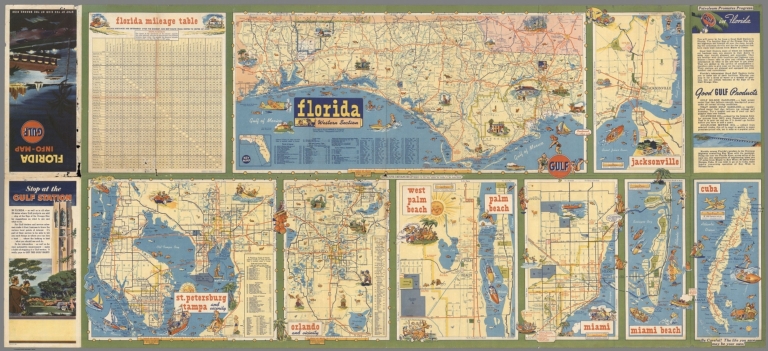
Rand McNally and Company
Full Title
Florida - Western Section. Jacksonville. St. Petersburg ��� Tampa. Orlando. West Palm Beach. Palm Beach. Miami. Miami Beach. Cuba. Florida Mileage Table.
List No
8966.001
Note
Date estimated. Various cities and regions of Florida.
Author
Rand McNally and Company
Full Title
Florida.
List No
8966.002
Note
Date estimated. Includes fishing chart.
Author
Unique Media Inc.
Full Title
Florida.
List No
9096.002
Author
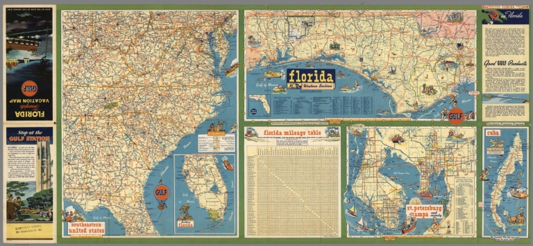
Rand McNally Company
Full Title
Florida (Western Section). Southeastern United States. St. Petersburg, Tampa and Vicinity. Cuba.
List No
9522.002
Note
Date estimated. Includes mileage table.
Author
Rand McNally Company
Full Title
Florida.
List No
9522.003
Note
Date estimated. Includes mileage table.
Author
Sales Management Magazine
Full Title
A pictorial map of Florida. (0n verso) Florida's population by counties. Copyright estimates by Sales Management Magazine, 1954.
List No
9967.001
Note
Two color maps on one sheet, both sides. Pictorial and population maps, folded into 23x15. Pictorial map issued under the signature of Nathan Mayo, Commissioner of Agriculture " Florida's identifying characteristics". Shows roads, highways, major cities, parks, India reservations, recreational activities, places of interest, the state natural resources and wildlife. Includes text and compass rose decorated with fish. On verso: Population map shows administrative divisions, Florida East Coast, Seaboard airline, Atlantic Cost line and other railways. Includes list of counties, Mileage char, population density, legend and compass rose decorated with state seal.
Author
Sales Management Magazine
Full Title
Florida's population by counties. Copyright estimates by Sales Management Magazine, 1954. (On verso) A pictorial map of Florida.
List No
9967.002
Note
Two color maps on one sheet, both sides. Pictorial and population maps, folded into 23x15. Pictorial map issued under the signature of Nathan Mayo, Commissioner of Agriculture " Florida's identifying characteristics". Shows roads, highways, major cities, parks, India reservations, recreational activities, places of interest, the state natural resources and wildlife. Includes text and compass rose decorated with fish. On verso: Population map shows administrative divisions, Florida East Coast, Seaboard airline, Atlantic Cost line and other railways. Includes list of counties, Mileage char, population density, legend and compass rose decorated with state seal.
1-28 of 28
|