|
REFINE
Browse All : Pictorial map of America
1-19 of 19
Author
Fadden, Ray
Full Title
Contributions of the American Indians.
List No
15783.000
Note
Date estimated.
Author
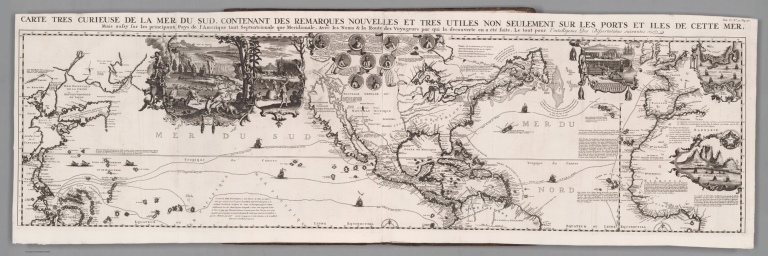
[Chatelain Henri, 1684-1743, Gueudeville, Nicolas]
Full Title
(Composite Map) Carte tres curieuse de la Mer du Sud, contenant des remarques nouvelles et tres utiles non seulement sur les ports et iles de cette mer, mais aussy sur les principaux pays de l'Amerique tant Septentroinale que Meridionale, Avec les noms & la route des voyageurs par qui la decouverte en a ete faite. Tom. VI. No. 30. Pag. 117. (to accompany) Atlas Historique ... Tome VI. A Amsterdam, chez L'Honore & Chatelain Libraires. M DCC XIX (1719).
List No
13272.713
Note
Composite map of the Pacific Ocean, centered on America.North and South sheets.
Author
Mora, Jo (1876-1947)
Full Title
Ye Olde Spanish Main. Designed and executed by Jo Mora. Copyrighted 1933 by Grace Line.
List No
10413.001
Note
This is the original drawing made by Jo Mora for the Spanish Main map. It is about 25% larger than the printed version and uncolored. See our printed color copy at 8592.000. Mora wrote "A Log of the Spanish Main" for the Grace Line Company and this map was issued in conjunction with the book. The map shows the areas of North, Central and South America that were visited by the Grace Line cruises. The carte was also called the Map of South America although that name does not appear on the map. For more information on Jo Mora's life and works, see http://www.jomoratrust.com
Author
Mora, Jo (1876-1947)
Full Title
Ye Olde Spanish Main. Designed and executed by Jo Mora. Copyrighted 1933 by Grace Line.
List No
8592.000
Note
Mora wrote "A Log of the Spanish Main" for the Grace Line Company and this map was issued in conjunction with the book. The map shows the areas of North, Central and South America that were visited by the Grace Line cruises. The carte was also called the Map of South America although that name does not appear on the map. For more information on Jo Mora's life and works, see http://www.jomoratrust.com
Author
Braniff Internation Airways
Full Title
(Text Page to) (Map of Americas) Braniff International Airways. (cover title) Braniff routes in review.
List No
11308.002
Note
Color pictorial map of Americas on sheet 54x43.5 folded into self wrapped covers 22.5x13.5. Shows the routes flown by Braniff International airways in the United States, Central and South America. Shows connection lines and certified routes. Includes legend, flags, and illustration of Braniff plane. On verso text and 5 maps showing routes to Houston, Texas - Balboa, Panama; Balboa, Panama - Lima Peru; Lima, Peru - La Paz, Bolivia; Lima, Peru - Rio de Janeiro, Brazil. And map showing the routes "From the Great Lakes of North America to Copacabana Beach, Rio. Date estimated.
Author
Braniff Internation Airways
Full Title
(Map of Americas) Braniff International Airways. (cover title) Braniff routes in review.
List No
11308.003
Note
Color pictorial map of Americas on sheet 54x43.5 folded into self wrapped covers 22.5x13.5. Shows the routes flown by Braniff International airways in the United States, Central and South America. Shows connection lines and certified routes. Includes legend, flags, and illustration of Braniff plane. On verso text and 5 maps showing routes to Houston, Texas - Balboa, Panama; Balboa, Panama - Lima Peru; Lima, Peru - La Paz, Bolivia; Lima, Peru - Rio de Janeiro, Brazil. And map showing the routes "From the Great Lakes of North America to Copacabana Beach, Rio. Date estimated.
Author
[Mazuyer, Gabriel, Lecomte, Georges (1867-1958), Boucher, Lucien (1889-1971)]
Full Title
A. Chiris en Amerique. (to accompany) Les etablissements Antoine Chiris, Dans le Monde. Les Etablissements Antoine Chiris dans le monde; Preface de Georges Lecomte de l'Academie Francaise; Texte historique de G. Mazuyer ; accompagne de 5 cartes illustrees de Lucien Boucher. Edite par les Etablissements Antoine Chiris, 1931.
List No
11452.014
Note
Pictorial map of Americas, showing section of Europe and Africa.
Author
Standard Oil Company of California
Full Title
Standard school broadcast pictorial map of Pan-America. Presented as a public service by Standard Oil Company of California. Copyright 1966 by Chevron Research Co. Printed in U.S.A. (insets) American Samoa. (with) Hawaii (U.S.).
List No
11725.000
Note
Pictorial map of America, with title cartouche decorated with various musical instrument, "This map was prepared especially for use in connection with the School Broadcast ...", published by the Chevron Research Company. The Standard School Broadcast was a weekly radio show, established in 1928, the show promoted music appreciation and history for children. The program continued until the 1970s. Map was issued to accompany the 38th series entitled "We Are Americans." It covers the entire Western Hemisphere and shows political boundaries, rivers and mountains. Also showing each country's flag, with illustrations of various dances of North and South America. Includes decorative compass rose and Tables of "Outline of the series and Musical instruments". Relief shown by shadings.
Author
Hagstrom Company, Inc.
Full Title
Shrinking Time and Distance.
List No
12166.001
Note
Date estimated.
Author
Hagstrom Company, Inc.
Full Title
Principal Airways Routes of the United States. (Text Page) Time chart ...
List No
12166.002
Note
Date estimated.
Author
Pan American Airways System
Full Title
The Routes of the Flying Clipper Ships.
List No
12331.000
Note
Date estimated.
Author
[Chatelain Henri, 1684-1743, Gueudeville, Nicolas]
Full Title
Carte tres curieuse de la Mer du Sud, contenant des remarques nouvelles et tres utiles non seulement sur les ports et iles de cette mer, mais aussy sur les principaux pays de l'Amerique tant Septentroinale que Meridionale, Avec les noms & la route des voyageurs par qui la decouverte en a ete faite. Tom. VI. No. 30. Pag. 117. (to accompany) Atlas Historique ... Tome VI. A Amsterdam, chez L'Honore & Chatelain Libraires. M DCC XIX (1719).
List No
13272.711
Note
1 engraved map on 2 sheets. Covers the Pacific Ocean, centered on America. Includes portion of Europe, western Africa, and eastern coast of Asia. With decorative vignettes illustrations of tribal life and Native American costums, mining, hunting grounds, native industry and, fishery/ Includes maps and plans detailing the Spice Islands, Strait of Gibraltar, Cape of Good Hope, Isthmus of Panama, and ports of Baldavia, Veracruz, Conception, Buenos Aires, Havana and San Sabastian and Aztec Pyramid. At the top center portraits of important explorers including Columbus, Vespucci, Magellan, Drake, and Dampier, various trade and exploration routes in the Pacific and Atlantic shown on the map.
Author
[Chatelain Henri, 1684-1743, Gueudeville, Nicolas]
Full Title
Carte tres curieuse de la Mer du Sud, contenant des remarques nouvelles et tres utiles non seulement sur les ports et iles de cette mer, mais aussy sur les principaux pays de l'Amerique tant Septentroinale que Meridionale, Avec les noms & la route des voyageurs par qui la decouverte en a ete faite. Tom. VI. No. 30. Pag. 117. (to accompany) Atlas Historique ... Tome VI. A Amsterdam, chez L'Honore & Chatelain Libraires. M DCC XIX (1719).
List No
13272.712
Note
1 engraved map on 2 sheets. Covers the Pacific Ocean, centered on America. Includes portion of Europe, western Africa, and eastern coast of Asia. With decorative vignettes illustrations of tribal life and Native American costums, mining, hunting grounds, native industry and, fishery/ Includes maps and plans detailing the Spice Islands, Strait of Gibraltar, Cape of Good Hope, Isthmus of Panama, and ports of Baldavia, Veracruz, Conception, Buenos Aires, Havana and San Sabastian and Aztec Pyramid. At the top center portraits of important explorers including Columbus, Vespucci, Magellan, Drake, and Dampier, various trade and exploration routes in the Pacific and Atlantic shown on the map.
Author
Neutroses-Vichy
Full Title
Nos possessions dans les Ameriques. Edite par les Laboratories Neutroses-Vichy. Petit Jean Imp. Paris. Pour la clarte du document, les iles Francaises de l'Atlantique ont ete Agrandies 20 Fois par rapport aux autres territoires.
List No
13350.001
Author
Neutroses-Vichy
Full Title
(Text page to) Nos possessions dans les Ameriques. Edite par les Laboratories Neutroses-Vichy. Petit Jean Imp. Paris. Pour la clarte du document, les iles Francaises de l'Atlantique ont ete Agrandies 20 Fois par rapport aux autres territoires.
List No
13350.002
Author
Haase, F.
Full Title
A map of the Americas. Designed by F. Haase. Copyright 1940 by R.R. Bowker Co.., New York.
List No
13517.000
Author
[General Drafting Company, Standard Oil]
Full Title
Pictorial Map of the Americas featuring the Pan American Highway.
List No
6780.003
Note
Date estimated. Pictographic map showing the Americas from Greenland through South America with illustrations of animals, plants, industry, agriculture, and points of interest.
Author
Pan American Airways Corporation
Full Title
On the routes of the flying clipper ship. Kenneth W. Thompson. Litho in U.S.A.
List No
8221.000
Note
Date estimated. Pictorial promotional map showing the area from San Francisco to a little south of Buenos Aires, advertising Pan-American Airlines air service throughout the Americas. Shows pictographs indicating tourist attractions, agriculture, wildlife, mines, etc. Relief shown pictorially. Includes an overview of the history and the importance of the major cities in Central America, South America and the Caribbean. The flying clipper ship routes were flown from 1931 to 1946. The flags of the nations of the Americas appear along the bottom of the map.
Author
[Wheeler, Hawthorne, Lawrence]
Full Title
(Americas) Wheeler. "Achievements sets no time of place to offer its rewards; Adventures never known before the present day affords! Lawrence Hawthorne."
List No
8437.000
Note
Engraved pictorial map of Americas. Date estimated. Shows major cities, plants, wild life, native settlements, landmarks, sailboats and steam ships, mountains and forests, Graf Zepprlin, and planes including Spirit of St. Louis and BYRD. Includes notation carthouche held by a sea turtle and mermaid. Compass rose oriented with north to the upper right. Relief shown pictorially.
1-19 of 19
|