|
REFINE
Browse All : Physical of Georgia
1-9 of 9
Author
[Scovel, James L., O'Brien, Emmett J]
Full Title
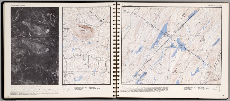
Crystalline Masses. Stock. Stone Mountain, GA. (inset) Stereotriplet of Stone Mountain, Georgia. (on opposite page) Complex Crystallines. Popolopen Lake, N.Y. Scale 1:25,000.
List No
0889.033
Note
Two contour maps on two pages, with text, and location map. Relief shown by contours and spot height.
Author
[Gorkin, Aleksandr Fedorovich, Kutafʹev, S. A.]
Full Title
Gruzinskaya SSR. Ekonomicheskaia karta. Gruzinskaya SSR. Bolshoi Sovietskii Atlas Mira II. Moskva 1939.
List No
11008.305
Note
2 maps on sheet 61x51. Showing physical and economic maps of Georgia. Includes 1 inset map and 1 profile.
Author
Gautier d'Agoty, J.F. (Jean Fabien), 1717-1785
Full Title
(Southern Atlantic Seaboard, (United States))
List No
12495.009
Note
Part of volume 1. Foldout. This may be one of the earliest color printed maps of North America.
Author
[Baranov, Anatolij Nikolaevič, Soviet Union. Glavnoe upravlenie geodezii i kartografii]
Full Title
Kavkaz. 46-47. Atlas Mira : 1954.
List No
13682.060
Note
Political and physical map of Caucasus. Showing political and regional boundaries, rivers, railways and roads. Relief shown by gradient tints, contours and spot heights. Depth shown by bathymetric tints, isolines and soundings.
Author
[3, Soviet Union. Glavnoe upravlenie geodezii i kartografii]
Full Title
Юго-Восток США = IUgo-Vostok Ssha. 236-237. Atlas Mira : 1954.
List No
13682.250
Note
Physical map of the Southeast of the United States. Showing state boundaries. Relief shown by shadings and spot heights. Depths shown by gradient tints, isolines and soundings.
Author
USSR (Union of Soviet Socialist Republics).
Full Title
22-23. RSFSR (Russian Soviet Federated Socialist Republic) in Europe, South. Georgian SSR, Azerbaijan SSR, Armenian SSR. The World Atlas.
List No
1603.034
Author
USSR (Union of Soviet Socialist Republics).
Full Title
203-204. United States of America, South East. The World Atlas.
List No
1603.215
Author
[Instituto Geographico di Agostini, Bayer, Herbert]
Full Title
U.R.S.S. Sezione Europea. (insets) Leningrado; Mosca.
List No
2170.062
Note
Relief shown as combined hachures, shaded relief, and hypsometric tints; bathymetry also tinted.
Author
Rand McNally and Company
Full Title
Relief Map of Georgia.
List No
2790.105
1-9 of 9
|