|
Author
Meyer, Joseph, 1796-1856
Full Title
Physikalische Karte vom Indischen Meere. Stahlstich (Direction v. Kleinknecht) aus der Schweinfurter Geographischen Graviranstalt des Bibliographischen Instituts zu Hildburghausen, Amsterdam, Paris u. Philadelphia. (in upper margin) Meyer's Zeitung Atlas. No. 99. (to accompany) Neuester Zeitungs-Atlas fur Alte und Neue Erdkunde. Herausgegeben von J. Meyer.
List No
11652.126
Note
Engraved hand color map of the Indian Ocean. Showing currents, temperatures, trading routes and explorers' tracks. Includes notes. Depth shown by isolines and soundings. Prime meridian is Paris.
Author
Marmocchi, Francesco Constantino, 1805-1858
Full Title
Geografia Fisica. Rosa di 32 Venti con i Loro Nomi Greci, Latini, Italiani, ed Oltramontani. Studio Giarre. (to accompany) Atlante di geografia universale ... Di F.C. Marmocchi. Firenze : per Vincenzo Batelli e Compagni 1842.
List No
11713.061
Note
Engraved hand colored diagram of the Rose of 32 winds with their names Greeks, Latinos, Italians, and Oltremontans. Includes notes.
Author
Schlieben, Wilhelm Ernst August von (1781 - 1839)
Full Title
Asien.
List No
12250.002
Author
Schlieben, Wilhelm Ernst August von (1781 - 1839)
Full Title
Africa.
List No
12250.003
Author
Schlieben, Wilhelm Ernst August von (1781 - 1839)
Full Title
Nordamerika und Westindien.
List No
12250.004
Author
Schlieben, Wilhelm Ernst August von (1781 - 1839)
Full Title
Suedamerika.
List No
12250.005
Author
Schlieben, Wilhelm Ernst August von (1781 - 1839)
Full Title
Australien.
List No
12250.006
Author
Gautier d'Agoty, J.F. (Jean Fabien), 1717-1785
Full Title
(New England (United States))
List No
12495.008
Note
Part of volume 1. Foldout. This may be one of the earliest color printed maps of North America.
Author
[Berghaus, Heinrich, Berghaus, Hermann, Schmidt, C., Risch, M.]
Full Title
Tieflander. Entw. v. Herm. Berghaus 1883, Ausg. 1887. Gez. v. C. Schmidt u. M. Risch. Gotha: Justus Perthes. (On upper margin) I. Abt. Geologie No. II. Berghaus' physikal atlas No. 2. (to Accompany) Berghaus' Physikalischer Atlas. (Begrundet 1836 durch Heinrich Berghaus) ... Gotha: Justus Perthes. 1892.
List No
4391.013
Note
14 color lithograph maps with insets on 1 sheet. Includes: Die Heutigen Niederlande, with insets: Niederlande in 1. Jahrhundert -- Niederlande in X. Jahrhundert, at scale of 1: 6,000,000. Fen District -- El-Ghor oder das Jordan Thal -- Kaspisches Tiefland und Manytsch Niederrung -- Natron-Seen -- El Fajum -- Nordrand der Libyschen Wuste -- Das Todte Thal -- Colorado-Wuste -- Nordrand der Algerischen Sahara -- Goban n. Paulistischke -- Sud-Australische Seen -- Tiefland Asale -- Assal-See. Relief shown by contours and spot heights. Depth shown by gradient tints and soundings. Prime meridian is Greenwich.
Author
[Berghaus, Heinrich, Berghaus, Hermann, Schmidt, C., Risch, M.]
Full Title
Thatigkeit des Erdinnern. Vulkane und Strand-veranderungen in Mollweide's flachenrechter Erdansicht. Entw. v. Herm. Berghaus 1885, Ausg. 1888. Gotha: Justus Perthes. (On upper margin) I. Abt. Geologie No. III. Berghaus' physikal atlas No. 3. (to Accompany) Berghaus' Physikalischer Atlas. (Begrundet 1836 durch Heinrich Berghaus) ... Gotha: Justus Perthes. 1892. (8 insets).
List No
4391.014
Note
Color lithograph maps with 8 insets and 1 profile view. Relief shown by contours and spot heights. Depth shown by gradient tints and soundings. Prime meridian is Greenwich. Insets: Jan Mayer, nordlichster Vulkan -- Erdbeben-Gebiete westliche -- Ostliche Erdbeben-Gebiete -- Insel Augustin (Tschernabura) -- Stromboli (Liparische Inseln) thatigster Vulkan -- Santorin (Kykladen) -- Sunda Strasse -- Tengger-Gebirge & Semiru. Includes legend and explanation.
Author
[Berghaus, Heinrich, Berghaus, Hermann, Rohrbach, C., Luddecke, R.]
Full Title
Grund und Boden. Bearbeitet v. Dr. C. Rohrbach, Red. v. Dr. R. Luddecke. Ausgabe 1892. Gotha: Justus Perthes. (On upper margin) I. Abt. Geologie No. IV. Berghaus' physikal atlas No. 4. (to Accompany) Berghaus' Physikalischer Atlas. (Begrundet 1836 durch Heinrich Berghaus) ... Gotha: Justus Perthes. 1892. (7 insets).
List No
4391.015
Note
Color lithograph double hemisphere map with 7 insets. Depth shown by gradient tints and soundings. Insets: Dunen des Nefud -- Sudliche Erdhalfte, Niederschlage im Juli -- Niederschlage im Januar, Nordliche Erdhalfte -- Dunen in Central Australien -- Dunen des Tharr -- Ostliche Areg -- Trockene Niederschlage. Includes legend and explanation.
Author
[Berghaus, Heinrich, Berghaus, Hermann]
Full Title
Eisverbreitung, einst und jetzt. Polar Ansicht der Erde in Lambert's flachenrechter Azimuthal-projection. Entw. v. Herm. Berghaus 1884, Ausg. 1886. Gotha: Justus Perthes. (On upper margin) I. Abt. Geologie No. V. Berghaus' physikal atlas No. 5. (to Accompany) Berghaus' Physikalischer Atlas. (Begrundet 1836 durch Heinrich Berghaus) ... Gotha: Justus Perthes. 1892. (7 insets).
List No
4391.016
Note
Color lithograph double hemisphere map with 7 insets. Depth shown by gradient tints, isoline and soundings. Relief shown by hachures. Insets: Der Rhein-Gletscher nach A. Favre -- Der Rhone Gletscher nach A. Falsan -- Seen-Gebiet in Nord-Amerika nach Chamberlin und Wright -- Die Europaischen Alpen -- Iseo-Gletscher nach Stroppani -- Der Loisach- und Inn-Gletscher n. Penck & Bayberger -- Die Sudlichen Alpen (Neu-Seeland) nach J. v. Haast. Includes legend and explanation.
Author
[Berghaus, Heinrich, Berghaus, Hermann, Risch, M., Hess, O., Kogel, F.]
Full Title
Gletscherkarte. Entw. v. Herm. Berghaus 1885, Ausg. 1888. Gez. v. M. Risch. Gest. v. O. Hess, Berge v. F. Kogel. Gotha: Justus Perthes. (On upper margin) I. Abt. Geologie No. VI. Berghaus' physikal atlas No. 6. (to Accompany) Berghaus' Physikalischer Atlas. (Begrundet 1836 durch Heinrich Berghaus) ... Gotha: Justus Perthes. 1892.
List No
4391.017
Note
21 color lithograph maps on 1 sheet. Relief shown by hachures and spot heights. Insets: Inlandeis des Frederickshaab-Glets chers nach J.A.D. Jensen -- Gronlandisches Binnen-Eis -- Justedals Bra -- Jotun Fjeld -- Berner Oberland -- Gletscher des Halbinsel Kenai (Alaska) -- Aus dem sudlichen Gronland n. G. Holm -- Gletscher des Mount Tacoma (nach dem Northern Transcontinental Survey) von Bailey Willis -- Gletscher des Mount Shasta (nach dem U.S. Geological Survey) von J.S. Diller -- Gletscher von Oisans -- Nevado de Chillan nach A. Philippi -- San Rafael Gletscher -- Oetzthaler Gruppe -- Glockner Gruppe -- Ross-Gletscher (Sud-Georgien) -- Gletscher des Adai Choch (Kaukasus) nach M. v. Dechy -- Hohe von Schneegrenzen und Gletscher-Enden -- Gletscher des Kasbek -- Serafschan Gletscher (Turkestan) nach I.W. Muschketow -- Neuseelandische Alpen nach R. v. Lendenfield.
Author
Chen, Haoji
Full Title
(Physical map of China). (to accompany) New atlas of China = Zhongguo xin yu tu. Chen Haoji zhu. Shang wu yin shu guan. Commercial Press Ltd., Shanghai. Minguo 6. (1917).
List No
9819.006
Note
Color map, No.1. Showing physical feature of China, terrain. Mountains, hills, and highlands, Plateau of Tibet, etc. Relief shown by gradient tints and contours. Depth shown by gradient tints.
Author
Maury, Matthew Fontaine, 1806-1873
Full Title
VI. Gulf Stream and drift. (to accompany) The Physical Geography of the Sea. By M.F. Maury. An Entirely New Edition, With Addenda. (inset diagram) Thermal section of the the Gulf Stream
List No
0475.013
Note
Uncolored map with inset. Includes explanation and notes. Shows the channel of the Gulf Stream for summer and winter. The diagram represents thermometrical profile represented by cross section of the Gulf Stream.
Author
Bromme, Traugott
Full Title
8. Idealer Durchschnitt der Erdrinde ... Entworfen von Tr. Bromme. Ausgefuhrt v. E. Winckelmann. Stuttgart. Verlag von Krais & Hoffman. (to accompany) Atlas zur Physik der Welt. (with second title page) Atlas zu Alex. v. Humboldt's Kosmos ... Bromme. (with insets)
List No
1615.013
Note
Hand colored map. Shows cross section of the earth's crust. With 14 cross sections, text and table.
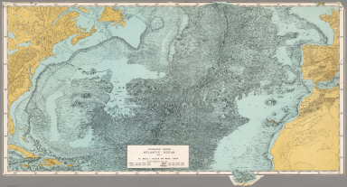
Author
[Heezen, Bruce C., Tharp, Marie]
Full Title
Physiographic Diagram, Atlantic Ocean (Sheet 1).
List No
6368.000
Note
Date from WorldCat. Color.
Author
[Eggertsson, Samuel, Forlag, V. Richters, Danish General Staff]
Full Title
Island, Landslagsuppdrattur (Fysisk Kort, Physical Map).
List No
7050.000
Note
Suitable for use in a standard classroom; viewable up to 40 feet. Language(s): English, Icelandic, Danish. Map is paper on muslin. Mounted on wood rods. Prime Meridian is Greenwich. Projection is not specified. Length of rolled wall map is 125 cm. Part of a series entitled, Skolakort I. Topics include: topography, hydrography, vegetation, human features, internal political boundaries, administrative and political. Department of Geography, University of California at Berkeley, Call Number 165-A-1.
Author
[Tardieu, P.F., Tardieu, P. (Pierre Antoine), 1784-1869]
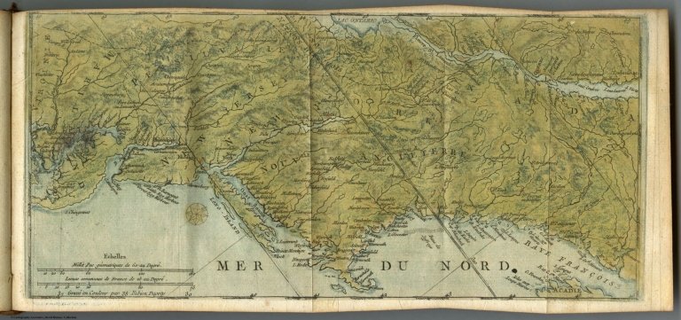
Full Title
(Composite of) A Map of Louisiana and Mexico. Carte de la Louisiane et du Mexique, Dressee par P. Tardieu fils aine, Gravee par P.A.F. Tardieu pere. Paris 1820. A Paris, chez: P.A.F. Tardieu, Place de l'Estrapade No. 34. C. Piequet, Geographe Graveur, Quai Conti No. 17. J. Goujon, Marchand de Cartes Geographiques, Rue du Bac No. 6. New York. Anthy. Girard , Mercht. Agent for the Author. Ecrit par Richomme.
List No
5838.001
Note
Combined sheet. Relief shown by hachures. Color used to tint boundaries. California and Nevada largely blank. Mount Diablo in San Francisco Bay Area labeled as M. San Juan Baptista.
Author
Anonymous
Full Title
(California -- Physical)
List No
7033.000
Note
Suitable for use in a standard classroom; viewable up to 40 feet. Language(s): English. Map is paper on muslin. Mounted on wood rods. Projection is not specified. Topics include: shaded relief, cities, "birds eye" picture of plaster model of California. Department of Geography, University of California at Berkeley, Call Number 611-A-9.
Author
[Geographical and Geological Survey of the Rocky Mountain Region (U.S.), Jenney, Walter Proctor, 1849-1921, Newton, Henry, 1845-1877]
Full Title
Bird's eye view of the Black Hills to illustrate the geological structure. Dept. of the Interior, U.S.G. and G. Survey, J.W. Powell, in charge. Geology of the Black Hills by Henry Newton, E.M. (Julius Bien, Lith. New York, 1879)
List No
2083.001
Author
Brue, Adrien Hubert, 1786-1832
Full Title
Mappemonde physique sur la projection de Mercator, par A.H. Brue, Geographe de S.A.R. Monsieur. A Paris, Chez l'Auteur, rue des Macons-Sorbonne, no. 9, et chez les principaux marchands de geographie. Mars 1821.
List No
0096.015
Note
Hand colored engraved map. Relief shown by hachures. Prime meridian: Paris.
Author
Brue, Adrien Hubert, 1786-1832
Full Title
Carte physique et routiere de la France, de la Suisse, et d'une partie des etats limitrophes par A. Brue, Geographe du Roi. Paris, 1827. Chez l'Auteur, rue des Macons-Sorbonne, no. 9, et chez les principaux m(archan)ds de cartes geographiques.
List No
0096.028
Note
Hand colored engraved map. Relief shown by hachures. Prime meridian: Paris. Shows canals, bishoprics, archbishoprics, forts, mineral baths, etc. Includes inset maps of Corsica and "Environs de Paris a la distance de 12 lieues." Originally issued in 2 sheets.
Author
Brue, Adrien Hubert, 1786-1832
Full Title
Carte generale physique et routiere des 22 cantons de la Confederation Suisse, par A.H. Brue, Geographe de S.A.R. Monsieur. A Paris, Chez l'Auteur, rue des Macons-Sorbonne, no. 9, et chez les principaux marchands de geographie. Aout 1822.
List No
0096.029
Note
Hand colored engraved map. Relief shown by hachures. Prime meridian: Paris.
Author
Brue, Adrien Hubert, 1786-1832
Full Title
Carte generale physique et routiere de la Monarchie Autrichienne dressee par A. Brue, Geographe du Roi. Paris, 1827. Chez l'Auteur, rue des Macons-Sorbonne, no. 9, et chez les principaux m(archan)ds de cartes geographiques.
List No
0096.034
Note
Hand colored engraved map. Relief shown by hachures. Prime meridian: Paris.
Author
Colton, G.W.
Full Title
Western Hemisphere. Eastern Hemisphere. Published by J. H. Colton. No. 172 William St. New York.
List No
0151.014
Note
Map showing Western and Eastern Hemisphere. Prime meridian is Greenwich.
Author
Colton, G.W.
Full Title
Northern Regions. Southern Regions. Published by J. H. Colton. No. 172 William St. New York.
List No
0151.015
Note
Map showing Arctic and Antarctic Regions. Prime meridians are Greenwich and Washington D. C. Printed in black and white.
Author
Colton, G.W.
Full Title
Colton's Map of the World On Mercator's Projection. Published by G. W & C. B. Colton & Co., No. 172 William St. New York.
List No
0152.012
Note
Shows routes and dates of exploration. Prime meridians are Greenwich and Washington D.C.
Author
Colton, G.W.
Full Title
Western Hemisphere. Eastern Hemisphere. Published by G. W & C. B. Colton & Co., No. 172 William St. New York.
List No
0152.013
Note
Prime meridian is Greenwich.
Author
Colton, G.W.
Full Title
Northern Regions. Southern Regions. Published by G. W & C. B. Colton & Co., No. 172 William St. New York.
List No
0152.014
Note
Map showing Arctic and Antarctic Regions. Prime meridians are Greenwich and Washington D.C.
Author
Colton, G.W.
Full Title
Colton's North America. Published by G. W & C. B. Colton & Co., No. 172 William St. New York.
List No
0152.015
Note
Map showing United States, British Possessions, Russian America, Alaska, Mexico, Central America, West Indies, Iceland and Greenland. Prime meridian is Washington D. C. Relief shown by hachures.
Author
Colton, G.W.
Full Title
Colton's Map of the Territory of Alaska (Russian America) Ceded by Russian to the United States. (inset) Diagram of the Middle States and North America. Published by G. W & C. B. Colton & Co., No. 172 William St. New York.
List No
0152.017
Note
Prime meridian is Greenwich. Relief shown by hachures. Includes Isothermal lines by Lorin Blodget.
Author
Cornell, S. S. (Sarah S.)
Full Title
The World showing the diversities of the land surface. (with) Comparative view of the principal lakes & islands in the World. Entered ... 1855, by S.S. Cornell ... Southern District of New York. New York: D. Appleton & Co., 443 & 445 Broadway, (1864)
List No
0197.002
Note
Engraved map. Hand colored. Relief shown by hachures. Contents: Northern Hemisphere -- Southern Hemisphere. Comparative view maps have titles: Islands of the Western Hemisphere -- Lakes of the Western Hemisphere -- Lakes of the Eastern Hemisphere -- Islands of the Eastern Hemisphere. Includes 3 world time charts from London, San Francisco and Sydney.
Author
Desjardins, Constant
Full Title
(Covers to) Physisch-statistisch und politischer Atlas von Europa ... in 6 Karten gross Format, schon illuminirt, mit erklarendem Text am Rand. Verfertiget zum Selbst Studium und der Jugend gewidmet von C. Desjardins ... Wien 1837. Zu haben bei dem Verfasser, Haarmarkt No. 731, und in allen soliden Kunst- und Buchhandlungen Deutschlands.
List No
0242A
Note
Not in Robinson; very early thematic atlas. Maps are a mixture of hand colored (land) and printed (water) full color. Title from cover. Covers are light yellow card board with the title printed in black ink.
Author
Desjardins, Constant
Full Title
Hydrographische Karte von Europa, oder darstellende Karte der beiden grossen Abdachungen, der Meer- und Flussgebiete etc., etc. der europaischen Halbinsel. Der Jugend gewidmet von C. Desjardins, Mitglied der Pariser Gesellschaften der Geographie ... Zu haben in Wien bei dem Verfasser, Bauernmarkt, Nr. 579, und in allen soliden Buch- und Kunsthandlungen (1837)
List No
0242.001
Note
Color map. Relief shown by hachures. Includes tables. Prime meridians: Ferro and Paris.
Author
Desjardins, Constant
Full Title
Orographische Karte von Europa, oder Beschreibung der Gebirgs-Systeme, Ketten und Landrucken, nebst der Bedeutung der vorzuglishsten Thaler, Haiden, Vorgebirge und Inseln von Europa; der Jugend gewidmet von C. Desjardins. (with) Hochste Spitzen der Haupt-Gebirgskette von Europa. Diese Karte is zu haben in Wien bei dem Herausgeber, Salvatorgasse Nr. 368, in der Kunsthandlung des H.F. Muller, Kohlmarkt, und in allen soliden Kunsthandlungen. (1837)
List No
0242.002
Note
Color map. Relief shown by hachures. Includes text. Prime meridians: Ferro and Paris.
Author
Johnston, Alexander Keith
Full Title
The Mountains, Table Lakes, Plains & Valleys of Europe ....
List No
0370.013
Author
Johnston, Alexander Keith
Full Title
The Mountains, Table Lands, Plains & Valleys of Asia ....
List No
0370.014
Author
Johnston, Alexander Keith
Full Title
The Mountains, Table Lands, Plains & Valleys of Africa ....
List No
0370.015
Author
Johnston, Alexander Keith
Full Title
The Mountains, Table Lands, Plains & Valleys of N. America ....
List No
0370.016
Author
Johnston, Alexander Keith
Full Title
The Mountains, Table Lands, Plains & Valleys of South America ....
List No
0370.017
Author
Johnston, Alexander Keith
Full Title
The Mountains, Table Lands, Plains & Valleys of the British Isles.
List No
0370.018
Author
Johnston, Alexander Keith, 1804-1871
Full Title
(Covers to) The physical atlas of natural phenomena by Alexander Keith Johnston, F.R.S.E., F.R.G.S., F.G.S. ... A new and enlarged edition. William Blackwood and Sons, Edinburgh and London, MDCCCLVI. [The Author reserves the right of translation]
List No
0372A
Note
2nd ed., enlarged. 1st ed. was 1848. Most of the maps are lithographed in color, but some are still engraved. The 1848 ed. was entirely engraved. Maps have both hand and printed color. Covers are half red leather dark teal cloth covered boards with "Atlas." embossed on the spine in gold .
Author
Johnston, Alexander Keith, 1804-1871
Full Title
(Title Page to) The physical atlas of natural phenomena by Alexander Keith Johnston, F.R.S.E., F.R.G.S., F.G.S. ... A new and enlarged edition. William Blackwood and Sons, Edinburgh and London, MDCCCLVI. [The Author reserves the right of translation]
List No
0372B
Author
Johnston, Alexander Keith, 1804-1871
Full Title
(Text Page to) The physical atlas of natural phenomena by Alexander Keith Johnston, F.R.S.E., F.R.G.S., F.G.S. ... A new and enlarged edition. William Blackwood and Sons, Edinburgh and London, MDCCCLVI. [The Author reserves the right of translation]
List No
0372C
Note
"Preface to the second edition ... A. Keith Johnston. Edinburgh, June 1856."
Author
Johnston, Alexander Keith, 1804-1871
Full Title
(Contents to) The physical atlas of natural phenomena by Alexander Keith Johnston, F.R.S.E., F.R.G.S., F.G.S. ... A new and enlarged edition. William Blackwood and Sons, Edinburgh and London, MDCCCLVI. [The Author reserves the right of translation]
List No
0372D
Note
List of plates, 1st sheet.
Author
Johnston, Alexander Keith, 1804-1871
Full Title
(Contents to) The physical atlas of natural phenomena by Alexander Keith Johnston, F.R.S.E., F.R.G.S., F.G.S. ... A new and enlarged edition. William Blackwood and Sons, Edinburgh and London, MDCCCLVI. [The Author reserves the right of translation]
List No
0372E
Note
List of plates, 2nd sheet.
Author
Nichol, J.P.
Full Title
The Physical Atlas. A. Notes on some General Principles in Geology; and their Applications.
List No
0372F
Author
Nichol, J.P.
Full Title
The Physical Atlas. A. Notes on some General Principles in Geology; and their Applications. (continued)
List No
0372G
Author
Nichol, J.P.
Full Title
The Physical Atlas. A. Notes on some General Principles in Geology; and their Applications. (continued). B. The Elevation of Mountains and the Contemporaneity of Parallel Chains.
List No
0372H
|