|
Author
[Geological Survey (U.S.), Conant, Louis C., Goudarzi, Gus H.]
Full Title
Geologic map of the Kingdom of Libya = خريطة جيولوجية للمملكة الليبية = Kharīṭah jiyūlūjīyah lil-Mamlakah al-Lībyah. Compiled by Louis C. Conant and Gus H. Goudarzi under the joint sponsership of the Kingdom of Libya and the Agency for International Development, U. S. Department of State. 1964. Department of Interior, United States Geological Survey. Kingdom of Libya. Ministries of National Economy, Petroleum Affairs, and Industry. Miscellaneous Geological Investigations, Map 1-350 A.
List No
13541.002
Note
Color geological map of Libya. Published by the U.S. Geological Survey, Washington, D.C., 1964.
Author
Duval, Henri (Henri Louis Nicolas), 1783-1854
Full Title
Tableau de physique et de météorologie. Par Henri Duval, Chevalier de la Légion-d'Honneur; Professeur d'Histoire, de Géographie, de Belles-Lettres, etc., etc. Delloye, Libraire, Place de la Bourse, No 13. Tous les Exemplaires ont le Timbre de l'Auteur. Imprimerie de Terzuolo, Successeur de M. Plassan, Rue de Vaugirard, No 11.
List No
14254.043
Note
Engraved, hand-colored view illustrating physical and meteorological phenomena, including the science of vision, color and lightning. Title translates to: Physics and meteorology table. Accompanied by descriptive text in tables within margins. With addresses in top corners: L'Auteur, Rue des Martyrs, no 23, Chaussée-d'Antin -- Adopté pour les maisons Royles d'Éducation de la Légion-d'Honneur. View is 18 x 19 cm, on sheet 42 x 61 cm. In third section: Sciences [= Science].
Author
Duval, Henri (Henri Louis Nicolas), 1783-1854
Full Title
Tableau de géologie et des révolutions du globe. Par Henri Duval, Chevalier de la Légion-d'Honneur; Professeur d'Histoire, de Géographie, de Belles-Lettres, etc., etc. Gravé par Laguillermie rue des Noyers No. 56. Delloye, Libraire, Place de la Bourse, No 13. Tous les Exemplaires ont le Timbre de l'Auteur. Imprimerie de Terzuolo, Successeur de M. Plassan, Rue de Vaugirard, No 11.
List No
14254.045
Note
Engraved, hand-colored view illustrating the tallest mountains from around the world, as well as volcanoes. Mountains indexed in association with a table giving peak heights. Title translates to: Table of geology and revolutions of the globe. Accompanied by descriptive text in tables within margins, covering geological phenomena, such as volcanoes, minerals and animal fossils. With addresses in top corners: L'Auteur, Rue des Martyrs, no 23, Chaussée-d'Antin -- Adopté pour les maisons Royles d'Éducation de la Légion-d'Honneur. View is 22 x 23 cm, on sheet 42 x 61 cm. In third section: Sciences [= Science].
Author
[Sydow, Emil von., 1812-1873, Wagner, Hermann, 1840-1929]
Full Title
Mitteleuropa Relief. Gotha : Justus Perthes. Sydow-Wagners method. Schul-Atlas. XXIII.
List No
13559.051
Note
Relief map of Central Europe. Vereinfachte Kegelprojektion. Includes inset map of Hamburg. Relief shown by gradient tints, hachures and spot height. Depth shown by bathymetric tints, isolines and sounding.
Author
[Glavnoe Upravlenie Navigat︠s︡ii i Okeanografii Ministerstva Oborony SSSR., Soviet Union. Voenno-Morskoĭ Flot.]
Full Title
Magnitnoe sklonenie dlia 1970 goda. (To accompany) Atlas okeanov : Tikhiy Okean = Atlas of the Oceans : Pacific Ocean. 1974.
List No
13622.190
Note
2 maps of the Pacific Ocean on 1 sheet. Showing the pattern of magnetic declination for 1965-70 by Isogonic lines.
Author
U.S. Geological Survey
Full Title
Machine-Made Physiographic Map of the Conterminous United States.
List No
12244.001
Note
Date estimated.
Author
[Instituto de Geografía (Academia de Ciencias de Cuba), Akademiia nauk SSSR. Institut geografii.]
Full Title
Fizicheskaia karta. Natsional'nyi Atlas Kuby : V oznamenovanie desi︠a︡toy godovshchiny revoli︠u︡tsii; Gavana, 1970.
List No
13567.014
Note
Physical and geological map of Cuba, with inset map: Central America and the Antilles, and 2 profiles.
Author
[Sydow, Emil von., 1812-1873, Wagner, Hermann, 1840-1929]
Full Title
Europa : übersicht des relief. Gotha : Justus Perthes. Sydow-Wagners method. Schul-Atlas. XXI.
List No
13557.044
Note
Geologic map of Europe. Relief shown by gradient tints, hachures and spot heights. Depth shown by bathymetric tints, isolines and soundings. Bonnesche projektion.
Author
[Sydow, Emil von., 1812-1873, Wagner, Hermann, 1840-1929]
Full Title
Mitteleuropa : Relief. Gotha : Justus Perthes. Sydow-Wagners method. Schul-Atlas. XXI.
List No
13557.058
Note
Relief map of Central Europe. Vereinfachte Kegelprojektion. Includes inset map of Hamburg. Shows political boundaries. Relief shown by gradient tints, hachures and spot height. Depth shown by bathymetric tints, isolines and sounding.
Author
[Sydow, Emil von., 1812-1873, Wagner, Hermann, 1840-1929]
Full Title
Südwest- Deutschland. Gotha : Justus Perthes. Sydow-Wagners method. Schul-Atlas. XXI.
List No
13557.089
Note
Map of Southwestern Germany. Vereinfachte Kegelprojektion.
Author
[Sydow, Emil von., 1812-1873, Wagner, Hermann, 1840-1929]
Full Title
Schweizer Alpen. Gotha : Justus Perthes. Sydow-Wagners method. Schul-Atlas : 21 Auflage. 1940.
List No
13557.093
Note
Map of Swiss Alps. With inset maps: Bern and Zurich. Vereinfachte Kegelprojektion.
Author
[Sydow, Emil von., 1812-1873, Wagner, Hermann, 1840-1929]
Full Title
Ungarische Tiefebene und Karpaten. Gotha : Justus Perthes. Sydow-Wagners method. Schul-Atlas. XXI.
List No
13557.095
Note
Map of the Hungarian Plain and Carpatian Mountains. With inset map: Budapest. Vereinfachte Kegelprojektion.
Author
[Sydow, Emil von., 1812-1873, Wagner, Hermann, 1840-1929]
Full Title
Vorderasien und Agypten. Gotha : Justus Perthes. Sydow-Wagners method. Schul-Atlas : 21 Auflage. 1940.
List No
13557.121
Note
Map of Middle East and Egypt. With inset: Frz. Somali. Bonne'sche Projektion.
Author
[Sydow, Emil von., 1812-1873, Wagner, Hermann, 1840-1929]
Full Title
Sudamerika : Sonderkarten zur Landerkunde. Subtropisches Sudamerika. Gotha : Justus Perthes. Sydow-Wagners method. Schul-Atlas : 21 Auflage. 1940.
List No
13557.145
Note
Map of South America. With 6 insets, Showing Isotherm, precipitation, economy, roads and transportation. Bonne'sche Projektion.
Author
Reynolds, James, 1817-1876
Full Title
Physical features of the land. Published by James Reynolds, 174 Strand, London.
List No
14338.003
Note
World map showing physical geography around the globe. Features mountain chains, peaks, plateaus ("table lands"), plains, valleys, lowlands, vegetation, deserts, drainage, coastlines and islands. Relief shown with hachures. Includes latitudinal and longitudinal lines, as well as a legend and explanatory notes throughout. Colored engraving double plate. Map is 43 x 69 cm, on sheet 51 x 77 cm. Descriptive notes in accompanying booklet preceding maps.
Author
[Instituto de Geografía (Academia de Ciencias de Cuba), Akademiia nauk SSSR. Institut geografii.]
Full Title
Mapa Fisico. Atlas nacional de Cuba : en el decimo aniversario de la Revolucion. La Habana 1970.
List No
13566.013
Note
Physical and geological map of Cuba, with inset map: America Central y Las Antillas, and 2 profiles of Pico Turquino.
Author
[Instituto de Geografía (Academia de Ciencias de Cuba), Akademiia nauk SSSR. Institut geografii.]
Full Title
Geologia. Atlas nacional de Cuba : en el decimo aniversario de la Revolucion. La Habana 1970.
List No
13566.015
Note
Geological map of Cuba. With inset of 6 Geological cross sections. Includes color coded reference to geological formations.
Author
Boyaciyan Agop Matbaasında
Full Title
(World map, mountains, volcanoes). Manissadjian & Co., Basle, Switzerland.
List No
13685.018
Note
Color map of the world principal mountains. Showing continents and oceans. Title provided by cataloger. Relief shown by hachures. Prime meridian: Greenwich.
Author
Boyaciyan Agop Matbaasında
Full Title
(World map of volcanoes). Manissadjian & Co., Basle, Switzerland.
List No
13685.021
Note
Color map of the world principal mountains and volcanoes. Title provided by cataloger. Relief shown by hachures. Prime meridian: Greenwich.
Author
[Baranov, Anatolij Nikolaevič, Soviet Union. Glavnoe upravlenie geodezii i kartografii]
Full Title
Fizicheskaia karta Mira. 1-2. Atlas Mira : 1954.
List No
13682.015
Note
Double hemisphere physical folded map of the world. Elevation shown by hypsometric tints and spot heights.
Author
[Baranov, Anatolij Nikolaevič, Soviet Union. Glavnoe upravlenie geodezii i kartografii]
Full Title
Soiuz Sovetskikh Sotsialisticheskikh Respublik : Fizicheskaia karta. 9-10. Atlas Mira : 1954.
List No
13682.022
Note
Physical map of the USSR. Relief shown by shading, gradient tints, and spot heights; Depths by Depths by bathymetric tints, isolines and soundings. Includes Great Circle nautical Scale and color coded reference.
Author
[Baranov, Anatolij Nikolaevič, Soviet Union. Glavnoe upravlenie geodezii i kartografii]
Full Title
Средняя азия (Восток) = Sredniaia Aziia (Vostok). 61-62. Atlas Mira : 1954.
List No
13682.075
Note
Physical map of Central East Asia. Relief shown by gradient tints, contours and spotlights. Depth shown by bathymetric tints, isolines and soundings.
Author
[Baranov, Anatolij Nikolaevič, Soviet Union. Glavnoe upravlenie geodezii i kartografii]
Full Title
Прибайкалье и Забайкалье = Pribaykal'ye i Zabaykal'ye. 73-74. Atlas Mira : 1954.
List No
13682.087
Note
Physical map of the Trans-Baikal Territory is part of the Siberian Federal District. Relief shown by gradient tints, contours and spotlights. Depth shown by bathymetric tints, isolines and soundings.
Author
[Baranov, Anatolij Nikolaevič, Soviet Union. Glavnoe upravlenie geodezii i kartografii]
Full Title
Европа, Физическая карта = Evropa, Fizicheskaia karta. 85-86. Atlas Mira : 1954.
List No
13682.099
Note
Physical map of Europe. Relief shown by gradient tints, contours and spotlights. Depth shown by bathymetric tints, isolines and soundings.
Author
[Baranov, Anatolij Nikolaevič, Soviet Union. Glavnoe upravlenie geodezii i kartografii]
Full Title
Северная италия, Свободная Территория Триест, Швейцария = Severnaia Italiia, Svobodnaia Territoriia Triyest, Shveytsariia. 115-116. Atlas Mira : 1954.
List No
13682.129
Note
Physical map of Northern Italy, Free Territory of Trieste and Switzerland. Showing political boundaries. Relief shown by gradient tints, contours and spot heights. Depth shown by bathymetric tints, isolines and soundings.
Author
[Baranov, Anatolij Nikolaevič, Soviet Union. Glavnoe upravlenie geodezii i kartografii]
Full Title
Азия = Aziia. 138-139. Atlas Mira : 1954.
List No
13682.152
Note
Physical map of Asia. Showing political boundaries. Relief shown by gradient tints, contours and spot heights. Depth shown by bathymetric tints, isolines and soundings.
Author
[Baranov, Anatolij Nikolaevič, Soviet Union. Glavnoe upravlenie geodezii i kartografii]
Full Title
Западный Китай = Zapadnyy Kitay. 156-157. Atlas Mira : 1954.
List No
13682.170
Note
Physical map of Western China. Relief shown by gradient tints, contours and spot heights. Depth shown by bathymetric tints, isolines and soundings.
Author
[3, Soviet Union. Glavnoe upravlenie geodezii i kartografii]
Full Title
Африка, Физическая = Afrika, Fizicheskaia. 191-192. Atlas Mira : 1954.
List No
13682.205
Note
Physical map of Africa. Relief shown by gradient tints, contours and spot heights. Depths shown by gradient tints, isolines and soundings.
Author
[3, Soviet Union. Glavnoe upravlenie geodezii i kartografii]
Full Title
Соединенные Штаты Америки = Soyedinennye Shtaty Ameriki. 227-228. Atlas Mira : 1954.
List No
13682.241
Note
Physical map of the United States. Relief shown by shadings and spot heights. Depths shown by gradient tints, isolines and soundings.
Author
[3, Soviet Union. Glavnoe upravlenie geodezii i kartografii]
Full Title
Запад США = Zapad SShA. 242-243. Atlas Mira : 1954.
List No
13682.256
Note
Physical map of the West of the United States. Showing state boundaries. Relief shown by shadings, contours and spot heights. Depths shown by gradient tints, isolines and soundings.
Author
[3, Soviet Union. Glavnoe upravlenie geodezii i kartografii]
Full Title
Атлантический Океан = Atlanticheskiy Okean. 278-279. Atlas Mira : 1954.
List No
13682.292
Note
Map of the Atlantic Ocean. Showing ocean currents, shipping and exploration routes. Relief shown by gradient tints and spot heights. Depths shown by bathymetric tints, isolines and soundings.
Author
Mektepler Uqün
Full Title
(Covers /Title Page to) جۇڭگو ئاتلسى = Jongu atlasi = Atlas of China. Ottura : Mektepler Uqün. Hormetler Neshriyâti. 1sr. edition, June 1984.
List No
13683.001
Note
Pictorial covers and title page to 1984 Atlas of China.
Author
Mektepler Uqün
Full Title
جۇڭگونىك يەرشەكلى = Chinese Earthquake. (to accompany) جۇڭگو ئاتلسى = Jongu atlasi = Atlas of China. Ottura : Mektepler Uqün. Hormetler Neshriyâti. 1sr. edition, June 1984.
List No
13683.005
Note
Physical map of China. With insets: maps and views. Relief shown by gradient tints and pictorially. Depth shown by bathymetric tints and soundings.
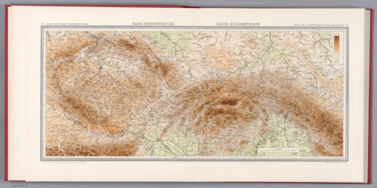
Author
[Pantoflíček, Jaroslav, Česká akademie věd a umění.]
Full Title
Mapa hypsometrica = Carte hypsometrique. Fr. Machát; M. Semík. 4. Atlas Republiky Československé = Atlas de la Republique Tchecoslovaque. Vydala Ceska akademie ved a umeni -1929- Editeur Nakladatelstvi Orbis, Praha : Tiskne Vojenskyì zeměpisnyì uìstav.
List No
13678.010
Note
Hypsometric map of Czechoslovakia on 2 sheets. Relief shown by contours, spot heights and gradient tints. Includes legend.
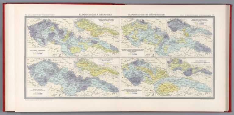
Author
[Pantoflíček, Jaroslav, Česká akademie věd a umění.]
Full Title
Klimatologie a geofisika = Climatologie et geophysique. J. Plihal. A. Gregor. 11. Atlas Republiky Československé = Atlas de la Republique Tchecoslovaque. Vydala Ceska akademie ved a umeni -1931- Editeur Nakladatelstvi Orbis, Praha : Tiskne Vojenskyì zeměpisnyì uìstav.
List No
13678.017
Note
4 maps on 2 sheets, with insets. Showing number of clear days; Average maximum precipitation in 24 hours, Annual number of sunshine hours; Minimum temperature; Earthquake map. Includes legend.
Author
[Geological Survey (U.S.), Harrison, Richard Edes]
Full Title
Shaded relief / Richard Edes Harrison, 1969.
List No
14359.041
Note
Physical map representing the United States, featuring relief, as of 1969. Shows topography, bodies of water, drainage, coastlines and islands. Relief shown with color coding. Includes a legend, latitudinal and longitudinal lines, as well as a bar scale and scale statement. With two inset maps: Principal islands of Hawaii -- Alaska. Presented with Albers Equal Area Projection. Colored lithograph. Map is 43 x 66 cm, on double sheet 49 x 71 cm. Accompanying descriptive text on page 55. Appears in Special subject maps section, subsection Physical : Landforms.
Author
[Geological Survey (U.S.), Hammond, Edwin H.]
Full Title
Classes of land-surface form / adapted from Edwin H. Hammond, "Classes of land surface form in the forty-eight states, U. S.A.," Annals of the Assoc. of Am. Geographers, V. 54, no. 1, 1964, map supp. no. 4, 1:5,000,000.
List No
14359.045
Note
Physical map representing the United States, featuring different land surfaces, such as plains and mountains, as of 1964. Shows political boundaries, topography, bodies of water, drainage, coastlines and islands. Relief shown with color coding. Includes a legend, latitudinal and longitudinal lines, as well as a bar scale and scale statement. With two inset maps: Principal islands of Hawaii -- Alaska. Presented with Albers Equal Area Projection. Colored lithograph. Map is 43 x 66 cm, on double sheet 49 x 71 cm. Accompanying descriptive text on page 55. Appears in Special subject maps section, subsection Physical : Landforms.
Author
[Geological Survey (U.S.), U.S. Coast and Geodetic Survey, United States. Environmental Science Services Administration]
Full Title
Major recorded earthquakes / compiled by U. S. Geological Survey from 1965 data provided by U. S. Coast and Geodetic Survey, Environmental Science Services Administration.
List No
14359.048
Note
Physical map representing the United States, featuring major earthquakes according to intensity, as of 1965. Shows political boundaries, topography, bodies of water, drainage, coastlines and islands. Relief shown with shading. Includes a legend, latitudinal and longitudinal lines, as well as a bar scale and scale statement. With five inset maps: Inset 1 -- Inset 2 -- Inset 3 -- Principal islands of Hawaii -- Alaska. Presented with Albers Equal Area Projection. Colored lithograph. Map is 43 x 66 cm, on double sheet 49 x 71 cm. Accompanying descriptive text on page 55. Appears in Special subject maps section, subsection Physical : Geophysical forces.
Author
[Geological Survey (U.S.), Dolan, Robert, Bosserman, Kenton, Felder, Wilson]
Full Title
Coastal landforms / compiled by Robert Dolan, University of Virginia, assisted by Kenton Bosserman and Wilson Felder, 1967.
List No
14359.057
Note
Physical map representing the United States, featuring coastal landforms, as of 1967. Shows coastline configuration and composition, shoreline characteristics, political boundaries, topography, bodies of water, drainage, coastlines, islands and bathymetry. Relief shown with shading. Includes a legend, latitudinal and longitudinal lines, as well as a bar scale and scale statement. With six inset maps: 1. Sandy Hook to Cape Ann -- 2. Chesapeake Bay and vicinity -- 3. San Francisco Bay Area -- 4. Puget Sound and vicinity -- Principal islands of Hawaii -- Alaska. Presented with Albers Equal Area Projection. Colored lithograph. Map is 43 x 66 cm, on double sheet 49 x 71 cm. Appears in Special subject maps section, subsection Physical : Marine features.
Author
[Geological Survey (U.S.), United States. Naval Oceanographic Office]
Full Title
Sea temperature and salinity / compiled from information provided by U. S. Naval Oceanographic Office, 1968.
List No
14359.060
Note
Sixteen physical maps representing the United States, featuring ocean temperature and salinity, as of 1968. Maps show maximum, minimum and mean temperature in all four seasons, sea surface salinity, political boundaries, bodies of water, coastlines and islands. Maps include legends, as well as bar scales and scale statements. With two inset maps within each map: Principal islands of Hawaii -- Alaska. Colored lithograph. Maps are each 10 x 16 cm, on double sheet 49 x 71 cm. Accompanying descriptive text on page 80. Maps appear in Special subject maps section, subsection Physical : Marine features.
Author
[Geological Survey (U.S.), Küchler, A. W. (August William), 1907-1999]
Full Title
Potential natural vegetation / A. W. Küchler, University of Kansas, 1966.
List No
14359.066
Note
Physical map representing the United States, featuring vegetation, as of 1966. Shows soil vegetation (such as forests and grasslands), political boundaries, bodies of water, drainage, coastlines and islands. Includes legends, latitudinal and longitudinal lines, as well as a bar scale and scale statement. Presented with Albers Equal Area Projection. Colored lithograph. Map is 43 x 66 cm, on double sheet 49 x 71 cm. Accompanying descriptive text on page 89. Appears in Special subject maps section, subsection Physical : Soils.
Author
[Geological Survey (U.S.), United States. Environmental Data Service, United States. Environmental Science Services Administration]
Full Title
Mean monthly sunshine / prepared by U. S. Geological Survey in 1965 from Environmental Data Service, Environmental Science Services Administration records for the period 1931-1960 -- January -- February -- March -- April -- May -- June -- July -- August -- September -- October -- November -- December -- January / adapted from 1:30,000,000-scale maps by Environmental Data Service, Environmental Science Services Administration for the period 1931-1960.
List No
14359.069
Note
Thirteen physical maps representing the United States, featuring the monthly mean for sunshine, as well as monthly sunshine for each month of the year, based upon the period from 1931 to 1960. Maps also show political boundaries, bodies of water, drainage, coastlines and islands. Maps include a legend, as well as a bar scale and scale statements (scales differ). Presented with Albers Equal Area Projection. With two inset maps within each map: Principal islands of Hawaii -- Alaska. Colored lithograph. Together, maps are 42 x 65 cm, on double sheet 49 x 71 cm. Maps appear in Special subject maps section, subsection Physical : Climate.
Author
[Geological Survey (U.S.), United States. Environmental Data Service, United States. Environmental Science Services Administration]
Full Title
Monthly precipitation means and extremes / prepared by U. S. Geological Survey in 1965 from Environmental Data Service, Environmental Science Services Administration records for the period 1931-1960 -- January -- February -- March -- April -- May -- June -- July -- August -- September -- October -- November -- December -- January / adapted from 1:5,000,000-scale maps by Environmental Data Service, Environmental Science Services Administration for the period 1931-1960.
List No
14359.072
Note
Thirteen physical maps representing the United States, featuring the monthly mean for precipitation, as well as monthly precipitation for each month of the year, based upon the period from 1931 to 1960. Maps also show political boundaries, bodies of water, drainage, coastlines and islands. Maps include a legend, as well as a bar scale and scale statements (scales differ). Presented with Albers Equal Area Projection. With two inset maps within each map: Principal islands of Hawaii -- Alaska. Colored lithograph. Together, maps are 42 x 65 cm, on double sheet 49 x 71 cm. Maps appear in Special subject maps section, subsection Physical : Climate.
Author
[Geological Survey (U.S.), United States. Environmental Data Service, United States. Environmental Science Services Administration]
Full Title
Mean annual cooling degree-days, based on data for the period 1931-1960 -- Mean annual heating degree-days, based on data for the period 1931-1960 / adapted from 1:20,000,000-scale maps by Environmental Data Service, Environmental Science Services Administration.
List No
14359.079
Note
Two physical maps representing the United States, featuring mean annual cooling and heating degree days, based upon the period from 1931 to 1960. Maps also show political boundaries, bodies of water, drainage, coastlines and islands. Maps include legends, as well as bar scales and scale statements. Presented with Albers Equal Area Projection. With two inset maps within each map: Principal islands of Hawaii -- Alaska. Colored lithograph. Together, maps are 42 x 31 cm, on sheet 49 x 35 cm. Maps appear in Special subject maps section, subsection Physical : Climate.
Author
[Geological Survey (U.S.), Harrison, Richard Edes]
Full Title
Shaded relief / Richard Edes Harrison, 1969.
List No
14359.261
Note
An experimental printing of Richard Edes Harrison's hand drawn relief map of 1964. This became the base topography of sheets 56-57, Shaded Relief by Harrison dated 1969. Not part of the atlas but acquired with a set of individual maps some of which were sold as single sheets by the U.S. Geological Survey.
Author
Mexico. Direccion de Estudios Geográficos y Climatologicos
Full Title
(Title Page 1) Atlas geografico de la Republica Mexicana : Secretaria de Agricultura y Fomento : Direccion de Estudios Geograficos y Climatologicos 1919-1921.
List No
10559.001
Note
Thirty-two numbered maps, most followed by a relief map and a geologic map. Full color. Some maps, 2nd edition. Maps were also issued separately. Cover - title page shows full color view of Southwestern Coast of North America, with decorative Mayan illustration on the background, and a Maya Indian drawing map. Seccion de cartografia: Jefe: Ing. Sotero Prieto. Jefe Ing. Luciano Lopez Sorcini. Zincografos: Antonio Hernandez , et al. Seccion de calculos: Jefe. Ing. Ricardo Toscano.
Author
Mexico. Direccion de Estudios Geográficos y Climatologicos
Full Title
(Text Page) Atlas geografico (to accompany) Atlas Geografico de la Republica Mexicana : Secretaria de Agricultura y Fomento Direccion de Estudios Geograficos y Climatologicos 1919-1921.
List No
10559.002
Note
Thirty-two numbered maps, most followed by a relief map and a geologic map. Full color. Some maps, 2nd edition. Maps were also issued separately. Cover - title page shows full color view of Southwestern Coast of North America, with decorative Mayan illustration on the background, and a Maya Indian drawing map. Seccion de cartografia: Jefe: Ing. Sotero Prieto. Jefe Ing. Luciano Lopez Sorcini. Zincografos: Antonio Hernandez , et al. Seccion de calculos: Jefe. Ing. Ricardo Toscano.
Author
Mexico. Direccion de Estudios Geográficos y Climatologicos
Full Title
(Text Page) Atlas geografico (to accompany) Atlas Geografico de la Republica Mexicana : Secretaria de Agricultura y Fomento Direccion de Estudios Geograficos y Climatologicos 1919-1921.
List No
10559.003
Note
Thirty-two numbered maps, most followed by a relief map and a geologic map. Full color. Some maps, 2nd edition. Maps were also issued separately. Cover - title page shows full color view of Southwestern Coast of North America, with decorative Mayan illustration on the background, and a Maya Indian drawing map. Seccion de cartografia: Jefe: Ing. Sotero Prieto. Jefe Ing. Luciano Lopez Sorcini. Zincografos: Antonio Hernandez , et al. Seccion de calculos: Jefe. Ing. Ricardo Toscano.
Author
Mexico. Direccion de Estudios Geográficos y Climatologicos
Full Title
(Title Page 2) Tipos y signos convencionales usados en el Atlas geografico de la Republica Mexicana : construido y editado en la Direccion de Estudios Geograficos y Climatologicos.
List No
10559.004
Note
Thirty-two numbered maps, most followed by a relief map and a geologic map. Full color. Some maps, 2nd edition. Maps were also issued separately. Cover - title page shows full color view of Southwestern Coast of North America, with decorative Mayan illustration on the background, and a Maya Indian drawing map. Seccion de cartografia: Jefe: Ing. Sotero Prieto. Jefe Ing. Luciano Lopez Sorcini. Zincografos: Antonio Hernandez , et al. Seccion de calculos: Jefe. Ing. Ricardo Toscano.
Author
Mexico. Direccion de Estudios Geográficos y Climatologicos
Full Title
(Relief map of Republica Mexicana). ( to accompany) Atlas geografico de la Republica Mexicana 1919-1921.
List No
10559.007
Note
Untitled colored relief map. Relief shown by shadings. Depth shown by isolines and soundings. Title supplied by cataloger.
|