|
Author
[Petermann, Augustus., Milner, Thomas]
Full Title
Zoological Geography. No. 11. Zoological Map Showing the Distribution of the Principal Mammiferous Animals (Class Mammalia) Over the Globe. Constructed by Augustus Petermann, F.R.G.S. Engraved by John Dower, Pentonville, London. London: Published by Orr and Compy. Amen Corner, Paternoster Row.
List No
0710.086
Author
[Petermann, Augustus., Milner, Thomas]
Full Title
(Text Page) Annotations to the Maps: Zoological Geography XI.
List No
0710.087
Author
[Petermann, Augustus., Milner, Thomas]
Full Title
(Text Page) Annotations to the Maps: Zoological Geography XI (continued).
List No
0710.088
Author
[Petermann, Augustus., Milner, Thomas]
Full Title
Zoological Geography. No. 12. Zoological Map Showing the Distribution of the Principal Birds and Reptiles (Aves et Reptilia) Over the Globe. Constructed by Augustus Petermann, F.R.G.S. Engraved by John Dower, Pentonville, London. London: Published by Orr and Compy. Amen Corner, Paternoster Row.
List No
0710.089
Author
[Petermann, Augustus., Milner, Thomas]
Full Title
(Text Page) Annotations to the Maps: Zoological Geography XII.
List No
0710.090
Author
[Petermann, Augustus., Milner, Thomas]
Full Title
(Text Page) Annotations to the Maps: Zoological Geography XII (continued).
List No
0710.091
Author
[Petermann, Augustus., Milner, Thomas]
Full Title
Ethnography. No. 13. Ethnographical Map of the World showing the distribution of the Human Race in the Middle of the 19th Century. Constructed by Augustus Petermann, F.R.G.S. Engraved by John Dower, Pentonville, London. London: Published by Orr and Compy. Amen Corner, Paternoster Row.
List No
0710.092
Note
Numerous races clustered into groups: Iranian, Turanian, Negroes, Hottentots, Pelagian Negroes, and Native Americans.
Author
[Petermann, Augustus., Milner, Thomas]
Full Title
(Text Page) Annotations to the Maps: Ethnography XIII.
List No
0710.093
Author
[Petermann, Augustus., Milner, Thomas]
Full Title
(Text Page) Annotations to the Maps: Ethnography XIII (continued).
List No
0710.094
Author
[Petermann, Augustus., Milner, Thomas]
Full Title
General Physical Geography. No.14. Physical Map of the British Isles. Showing their orography, climatology, and some Botantical and Zoological Features. Constructed by Augustus Petermann, F.R.G.S. Engraved by John Dower, Pentonville, London. London: Published by Orr and Compy. Amen Corner, Paternoster Row.
List No
0710.095
Note
Relief shown with hachures.
Author
[Petermann, Augustus., Milner, Thomas]
Full Title
(Text Page) Annotations to the Maps: Physical Map of the British Isles. XIV.
List No
0710.096
Author
[Petermann, Augustus., Milner, Thomas]
Full Title
(Text Page) Annotations to the Maps: Physical Map of the British Isles (continued). XIV.
List No
0710.097
Author
[Petermann, Augustus., Milner, Thomas]
Full Title
Physical Map of Palestine and the Adjacent Countries. Constructed by Augustus Petermann, F.R.G.S. Engraved by John Dower, Pentonville, London. London: Published by Orr and Compy. Amen Corner, Paternoster Row.
List No
0710.098
Note
Includes diagram of monthly climate. Relief shown by hachures.
Author
[Petermann, Augustus., Milner, Thomas]
Full Title
(Text Page) Annotations to the Maps: Physical Map of Palestine and the Adjacent Countries. XV.
List No
0710.099
Author
[Petermann, Augustus., Milner, Thomas]
Full Title
(Text Page) Annotations to the Maps: Physical Map of Palestine and the Adjacent Countries. XV (continued). Index to the Atlas of Physical Geography.
List No
0710.100
Author
[Petermann, Augustus., Milner, Thomas]
Full Title
(Text Page) Annotations to the Maps: Index to the Atlas.
List No
0710.101
Author
[Petermann, Augustus., Milner, Thomas]
Full Title
(Text Page) Annotations to the Maps: Index to the Atlas (continued).
List No
0710.102
Author
[Petermann, Augustus., Milner, Thomas]
Full Title
(Text Page) Index to the Atlas (continued). Works Published by William S. Orr and Co.
List No
0710.103
Author
[Petermann, Augustus., Milner, Thomas]
Full Title
(Text Page) (Works Published by William S. Orr and Co., continued).
List No
0710.104
Author
[Scovel, James L., O'Brien, Emmett J]
Full Title
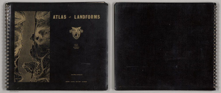
(Covers to) Atlas of Landforms. James L Scovel; Emmett J O'Brien; J C McCormack, (Major); R.B. Chapman; Department of Earth, Space and Grafic Sciences; United States Military Academy, West Point, New York. John Wiley and Sons Inc., New York. London. Sydney.
List No
0889.001
Note
Atlas, 164 pages, 94 maps, chiefly color. With XI-20 figures, Bibliography, and index. Bound in black heavy paper covers, 32x37 with title " Atlas of Landforms. Scover, O'Brien, McCormack, Chapman; John Wiley and Sons Inc. United States Military Academy." and landform map of Hudson River in gilt.
Author
[Scovel, James L., O'Brien, Emmett J]
Full Title
(Title Page to) Atlas of Landforms. James L Scovel; Emmett J O'Brien; J C McCormack, (Major); R.B. Chapman; Department of Earth, Space and Grafic Sciences; United States Military Academy, West Point, New York. John Wiley and Sons Inc., New York. London. Sydney.
List No
0889.002
Note
Atlas, 164 pages, 94 maps, chiefly color. With XI-20 figures, Bibliography, and index. Bound in black heavy paper covers, 32x37 with title " Atlas of Landforms. Scover, O'Brien, McCormack, Chapman; John Wiley and Sons Inc. United States Military Academy." and landform map of Hudson River in gilt. (On verso) Copyrighy 1965. Earth Science Fund. Second printing, October, 1966 ...
Author
[Scovel, James L., O'Brien, Emmett J]
Full Title
(Contents to) Atlas of Landforms. James L Scovel; Emmett J O'Brien; J C McCormack, (Major); R.B. Chapman; Department of Earth, Space and Grafic Sciences; United States Military Academy, West Point, New York. John Wiley and Sons Inc., New York. London. Sydney.
List No
0889.003
Note
Atlas, 164 pages, 94 maps, chiefly color. With XI-20 figures, Bibliography, and index. Bound in black heavy paper covers, 32x37 with title " Atlas of Landforms. Scover, O'Brien, McCormack, Chapman; John Wiley and Sons Inc. United States Military Academy." and landform map of Hudson River in gilt. (On verso) Copyrighy 1965. Earth Science Fund. Second printing, October, 1966 ...
Author
[Scovel, James L., O'Brien, Emmett J]
Full Title
Index Map. Locations are Approximate. (inset maps) Alaska, Hawaiian Islands, and Manat. (to accompany) Atlas of Landforms. James L Scovel; Emmett J O'Brien; J C McCormack, (Major); R.B. Chapman; Department of Earth, Space and Grafic Sciences; United States Military Academy, West Point, New York. John Wiley and Sons Inc., New York. London. Sydney.
List No
0889.004
Note
Uncolored index map.
Author
[Scovel, James L., O'Brien, Emmett J]
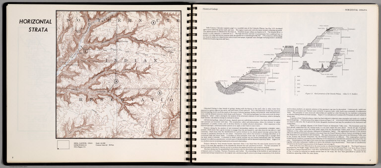
Full Title
Horizontal Strata. Soda Canyon, Colo.
List No
0889.005
Note
Historical Geology. Contour map, with outline location map. Relief shown by contours and spot height. On the opposite page, text, and cross section of rock formations of the Colorado Plateau. (After A.N. Strahler).
Author
[Scovel, James L., O'Brien, Emmett J]
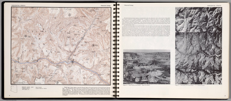
Full Title
Horizontal Strata. Bright Angel Ariz.
List No
0889.006
Note
Historical Geology. Contour map, with outline location map. Relief shown by contours and spot heightd. On the opposite page: text, and figures showing Grand Canyon of Colorado. (Space Air Photos), and Sterotriplet of the Grand Canyon. (U.S. Geological Survey).
Author
[Scovel, James L., O'Brien, Emmett J]
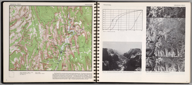
Full Title
Horizontal Strata. Zion National Park, Utah.
List No
0889.007
Note
Historical Geology. Contour map, includes text, and outline location map. Relief shown by contours and spot height. Three figures on the opposite page, showing Radioactive decay rates, Zion Canyon from Observation Point, and Stereotriplet of Zion canyon.
Author
[Scovel, James L., O'Brien, Emmett J]
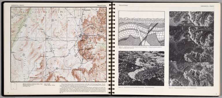
Full Title
Horizontal Strata. Bryce Canyon National Park, Utah.
List No
0889.008
Note
Historical Geology. Contour map, includes text, and outline location map. Relief shown by contours and spot height. Three figures on the opposite page, showing numbered formation structure, Erosional forms in the Pink Cliffs of Bryce Canyon, and Stereotriplet of Bryce Canyon.
Author
[Scovel, James L., O'Brien, Emmett J]
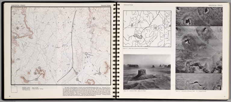
Full Title
Horizontal Strata. Oljeto, Utah.
List No
0889.009
Note
Contour map, includes text, and outline location map. Relief shown by contours and spot height. On the opposite page: Sketch map of a portion of Colorado Plateau, Monument Valley, and Stereotriplet of Monument Valley.
Author
[Scovel, James L., O'Brien, Emmett J]
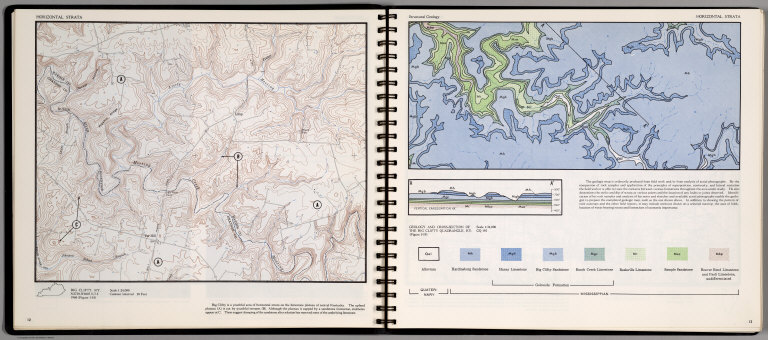
Full Title
Horizontal Strata. Big Clifty, KY.
List No
0889.010
Note
Contour map, includes text, and outline location map. Relief shown by contours and spot height.
Author
[Scovel, James L., O'Brien, Emmett J]
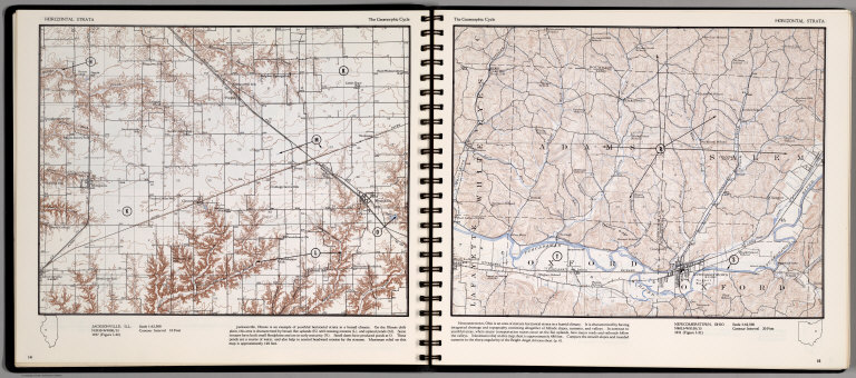
Full Title
Horizontal Strata. Jacksonville, Ill. (on the opposite page) Newcomerstown, Ohio. (on top of the page) Geomorphic Cycle.
List No
0889.011
Note
Two contour maps, includes text, and outline location map. Relief shown by contours and spot height.
Author
[Scovel, James L., O'Brien, Emmett J]
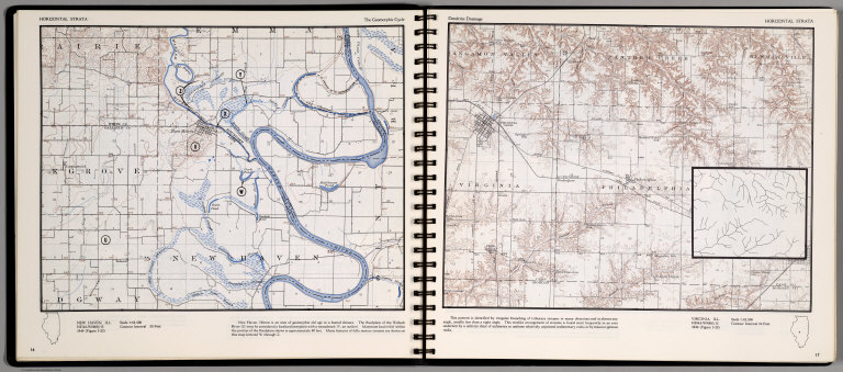
Full Title
Horizontal Strata. New Haven, Ill. (on top of the page) The Geomorphic Cycle. (on opposite page) Virginia, Ill. (on top of the page) Dendritic Drainage. (untitled inset) Treelike arrangement of streams.
List No
0889.012
Note
Contour map, includes text, and outline location map. Relief shown by contours and spot height.
Author
[Scovel, James L., O'Brien, Emmett J]
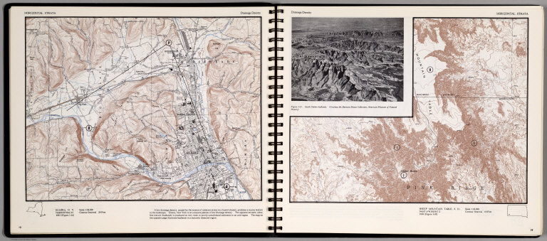
Full Title
Horizontal Strata. Elmira, N. Y. (on the opposite page)Sheep Mountain table, S.D. 1:24,000. (on top of the page) Dendritic Drainage. (inset view) South Dakota Badlands.(Courtesy of Barnum Brown Collection ...)
List No
0889.013
Note
Two contour maps, includes text, and outline location map. Relief shown by contours and spot height.
Author
[Scovel, James L., O'Brien, Emmett J]
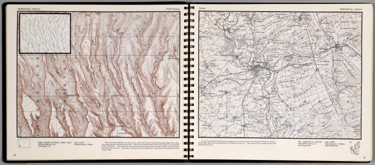
Full Title
Horizontal Strata. Paralle Drainage. Mesa Verde National Park, Colo. (on opposite page) Cuestas. Ste. Menehould, France. 1:50,000.
List No
0889.014
Note
Two contour maps, includes text, and outline location map. Inset on Mesa Verde Nation Park, showing magnified pattern of parallel main streams. Relief shown by contours and spot height.
Author
[Scovel, James L., O'Brien, Emmett J]
Full Title
Horizontal Strata. Cuestas. Rich Tazigzaout, Morocco. (on opposite page views of) Cuestas and plunging folds neat Rich Tazigzaout.
List No
0889.015
Note
Contour maps on two pages, includes text, and outline location map. Relief shown by contours and spot height.
Author
[Scovel, James L., O'Brien, Emmett J]
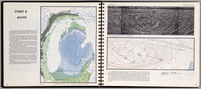
Full Title
Domes & Basin. Geology of the Michigan Basin. (on opposite page) Anticlinal Domes. Sinclair, Wyo. 1:24,000. (with inset view) Stereotriplet of Grenville Dome).
List No
0889.016
Note
Contour maps on two pages, includes text, and outline location map. Relief shown by contours and spot height. Depth shown by gradient tints.
Author
[Scovel, James L., O'Brien, Emmett J]
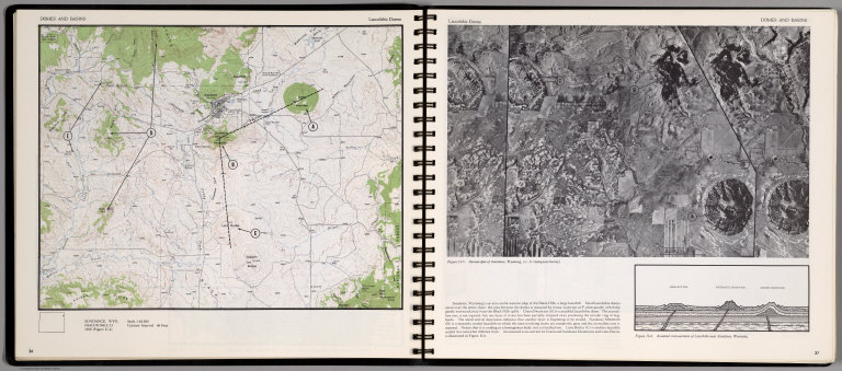
Full Title
Domes & Basin. Laccolithic Domes. Sundance, Wyo. (with view on opposite page): Stereotriplet of Suncance, Wyoming, and Assumed Cross-sections of Laccoliths near Sundance, Wyoming.
List No
0889.017
Note
Contour map, and a view on two pages, includes text, and outline location map. Relief shown by contours and spot height.
Author
[Scovel, James L., O'Brien, Emmett J]
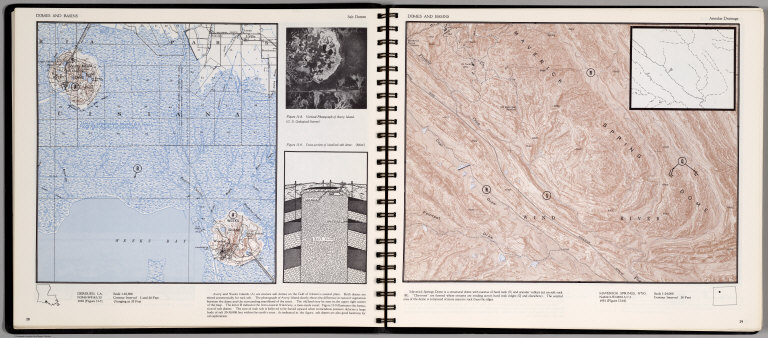
Full Title
Domes & Basin. Salt Domes. Derouen, LA. (on opposite page) Annular Drainage. Maverick Springs, Wyo. 1:24,000. With insets
List No
0889.018
Note
Two contour maps on two pages, includes text, and outline location map. Insets: Vertical photograph of Avery Island; Cross-section of idealized salt dome; and magnified inset showing folds in rock layers. Relief shown by contours and spot height.
Author
[Scovel, James L., O'Brien, Emmett J]
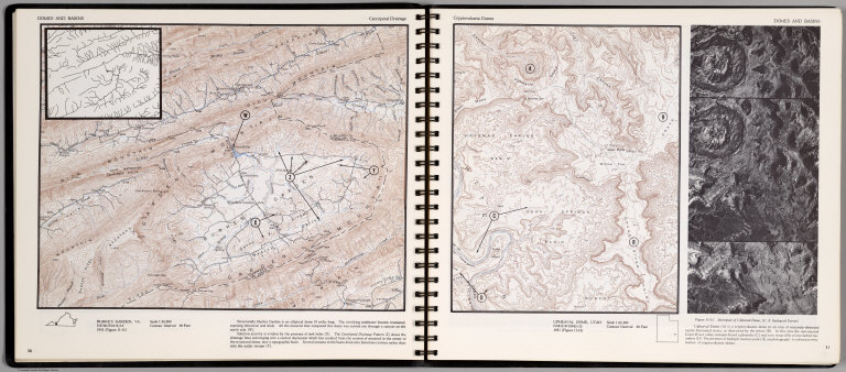
Full Title
Domes & Basin. Centripetal Drainage. Burkes Garden, VA. (on opposite page) Cryptovocanic Domes. Upheaval Dome, Utah. (with inset view) Stereopair of Upheaaval Dome ...
List No
0889.019
Note
Two contour maps on two pages, includes text, and outline location map. Inset: Magnified section of the Centripetal drainage patterns. Relief shown by contours and spot height.
Author
[Scovel, James L., O'Brien, Emmett J]
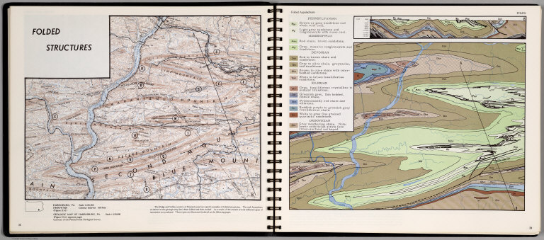
Full Title
Folded Structure. Harrisburg, PA. (opposite page) Geologic Map of Harrisburg, PA. 1:150,000. Folds.
List No
0889.020
Note
Contour and geologic maps on two pages, includes text, and outline location map. Relief shown by contours and spot height.
Author
[Scovel, James L., O'Brien, Emmett J]
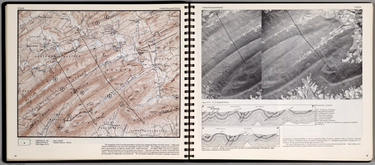
Full Title
Folds. Loysvill, PA. Folded Mountains-Humid.
List No
0889.021
Note
Contour map, view and cross-sections on two pages, includes text, and outline location map. Relief shown by contours and spot height.
Author
[Scovel, James L., O'Brien, Emmett J]
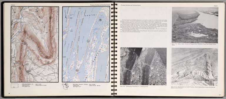
Full Title
Folds. Plunging Anticlines and Synclines-Humid. Hollidysburg, PA. Belcher Islands, Canada. 1:250,000.
List No
0889.022
Note
Two contour maps and three views on two pages, includes text, and outline location map. Views showing Belcher Islands; Hollidaysburg, Pennsylvania; and Sheep Mountain near Greybull, wyoming. Relief shown by contours and spot height.
Author
[Scovel, James L., O'Brien, Emmett J]
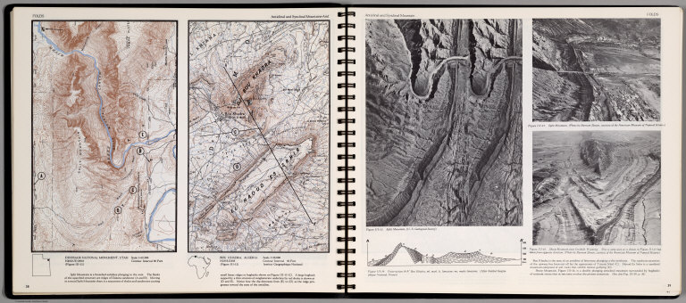
Full Title
Folds. Plunging Anticlinal and Synclinal Mountain-Arid. Dinosaur National Monument, Utah. Bou Khadra, Algeria. 1:50,000. (on opposite page) Anticlinal and Synclinal Mountain. (with three views).
List No
0889.023
Note
Two contour maps and three views and cross-section on two pages. Includes text, and outline location maps. Two views showing Split Mountin; Sheep Mountain near Grebull; Cross-section A-A' Bou khadra. Relief shown by contours and spot height.
Author
[Scovel, James L., O'Brien, Emmett J]
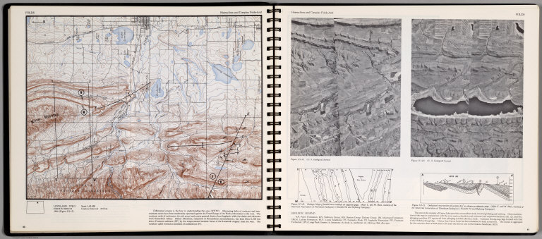
Full Title
Folds. Homoclines and Complex Folds-Arid. Loveland, Colo.
List No
0889.024
Note
Contour map, with text and outline location map. On opposite page Two views, geologic map of foothill area outlined on opposite page, with geologic legend, and Cross-section AA' as shown on opposite page. Relief shown by contours and spot height.
Author
[Scovel, James L., O'Brien, Emmett J]
Full Title
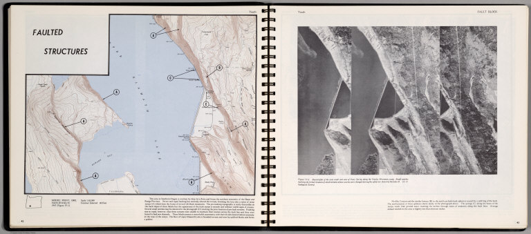
Faulted Structure. Youth. Modoc Point, Ore. (on opposite page) Stereotiplet of the area South and East Ouxy Spring along the Naylox Mountain scarp.
List No
0889.025
Note
Contour map,and stereotriplet view with text and outline location map. Relief shown by contours and spot height.
Author
[Scovel, James L., O'Brien, Emmett J]
Full Title
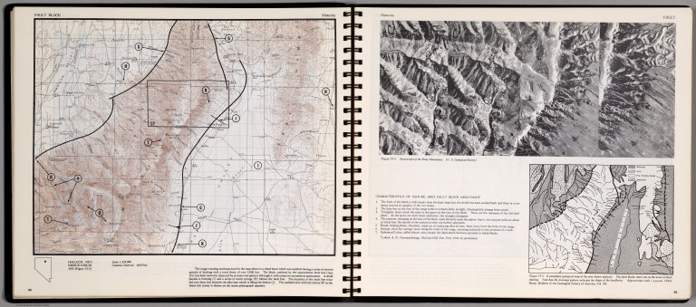
Fault Block. Maturity. Halleck, Nev. (on opposite page) Stereotiplet of the Ruby Mountains. (inset) A simplified Geological map of the area shown opposite.
List No
0889.026
Note
Contour map, and stereotriplet with text and outline location map. Relief shown by contours and spot height.
Author
[Scovel, James L., O'Brien, Emmett J]
Full Title
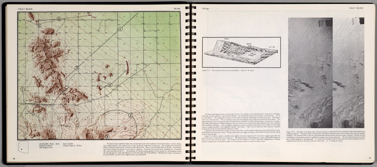
Fault Block. Old Age. Antelope Peak, Ariz. (on opposite page) Old Age. Stereopair of Antelope Peak, Arizona ... (inset) The Erosional cycle on an arid Fault Block.
List No
0889.027
Note
Contour map, and stereopair with text and outline location map. Relief shown by contours and spot height.
Author
[Scovel, James L., O'Brien, Emmett J]
Full Title
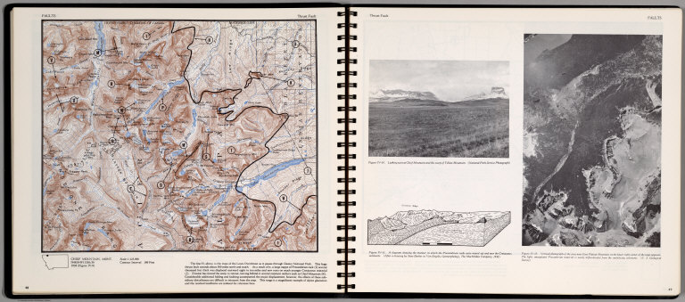
Faults. Trust Fault. Chief Mountain, Mont. (on opposite page) Trust Fault. Vertical photograph of the area near East Flat top Mountain ...
List No
0889.028
Note
Contour map, with location map. Insets: Looking West at Chief Mountain ..., and A Diagram showing the manner in which the Precambrian rocks were moved up and over Cretaceous sediments ... Relief shown by contours and spot height. Depth shown by soundings.
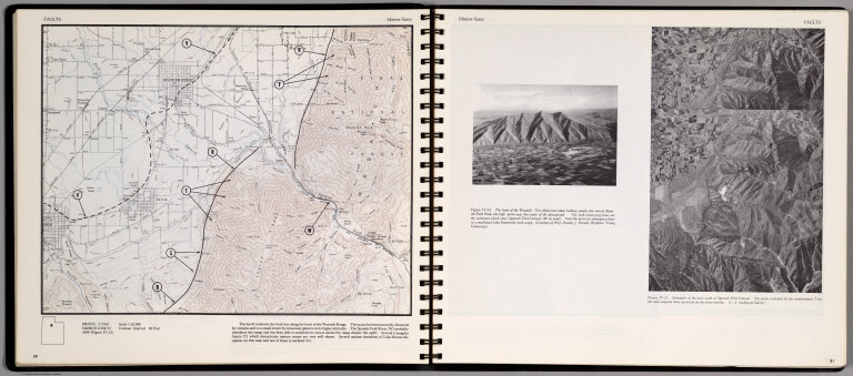
Author
[Scovel, James L., O'Brien, Emmett J]
Full Title
Faults. Mature Scrap. Provo, Utah. (on opposite page) Mature Scrap. Stereopair of the area south of Spanish Fork Canyon ...
List No
0889.029
Note
Contour map, with text. Relief shown by contours and spot height. Includes location map. Insets view: the front of the Wasatch ...
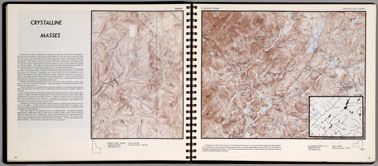
Author
[Scovel, James L., O'Brien, Emmett J]
Full Title
Crystalline Masses. Batholith. Rocky Bar, Idaho. (on opposite page) Rectangular Drainage. Elizabethtown, N.Y. Scale 1:62,500.(inset) Resulting in a rectangular drainage pattern.
List No
0889.030
Note
Contour map, with text, and location map. Relief shown by contours and spot height.
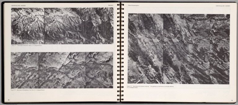
Author
[Scovel, James L., O'Brien, Emmett J]
Full Title
Crystalline Masses. Batholith. Stereotriplet of Rocky Bar, Idaho ... Stereotriplet of Elizabethtown, New York ... (on opposite page) Belted Metamorphic. Stereotriplet of San Andreas, California ...
List No
0889.031
Note
Three stereotriplets.
|