|
REFINE
Browse All : Physical Atlas of North America
1-28 of 28
Author
Cartee, Cornelius S.
Full Title
Map of North America. Designed To Accompany Cartee's "Elements Of Physical Geography. Engraved by G.W. Boynton. Entered ... 1856, by Hickling, Swan, And Brown ... Massachusetts. (to accompany) A School Atlas Of Physical Geography ... By Cornelius S. Cartee, A.M. M DCCC LVI.
List No
0129.006
Note
Hand color map. Includes explanation. Shows regions, cities, rivers. Relief shown by hachures and spot heights. Prime meridian is Greenwich.
Author
Johnston, Alexander Keith
Full Title
The Mountains, Table Lands, Plains & Valleys of N. America ....
List No
0370.016
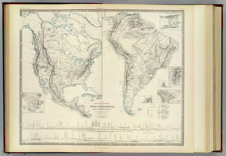
Author
[Johnston, Alexander Keith, 1804-1871, Rogers, Henry Darwin]
Full Title
The physical features of North & South America, showing the mountains, table-lands, plains & slopes. By A.K. Johnston, F.R.S.E. with original sections by H.D. Rogers. Engraved & printed by W. & A.K. Johnston. William Blackwood & Sons, Edinburgh & London. (1856)
List No
0372.008
Note
Two hand col. lithographed maps on 1 sheet. Relief shown by hachures and spot heights. Inset maps: Volcano of Jorullo. Scale (ca. 1:90,000) -- Island of Trinidad -- Table-land of Quito. Scale (ca. 1:8,000,000) -- Enlarged map of the Andes of Bolivia. Scale (ca. 1:16,000,000). Includes 4 cross sections. "Geology no. 7."
Author
Rogers, Henry Darwin
Full Title
The Physical Features of America: Its Mountains, Table-Lands, Plains, and Slopes. I. North America.
List No
0372X
Author
Rogers, Henry Darwin
Full Title
The Physical Features of America: Its Mountains, Table-Lands, Plains, and Slopes. I. North America. (continued) II. South America.
List No
0372Y
Author
Rogers, Henry Darwin
Full Title
The Physical Features of America: Its Mountains, Table-Lands, Plains, and Slopes. II. South America. (continued)
List No
0372Z
Author
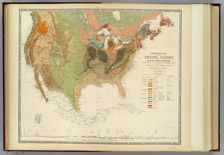
[Johnston, Alexander Keith, 1804-1871, Rogers, Henry Darwin]
Full Title
Geological map of the United States and British North America, constructed from the most recent documents & unpublished materials, for Keith Johnston's Physical atlas by Professor H.D. Rogers, Boston, U.S., 1855. Engraved & printed in colours by W. & A.K. Johnston. William Blackwood & Sons, Edinburgh & London. (1856)
List No
0372.009
Note
Col. lithographed map. Includes "A geological section across the Appalachian Mts. from the coast of New Jersey at Egg Harbour to Lake Ontario near the Niagara River, ... by Prof. Henry Darwin Rodgers (sic), U.S., 1854. Covers also Northern Mexico. "Geology no. 8."
Author
Rogers, Henry Darwin
Full Title
Geological Map of the United States and British North America.
List No
0372AA
Author
Rogers, Henry Darwin
Full Title
Geological Map of the United States and British North America. (continued)
List No
0372AB
Author
Rogers, Henry Darwin
Full Title
Geological Map of the United States and British North America. (continued)
List No
0372AC
Author
Rogers, Henry Darwin
Full Title
Geological Map of the United States and British North America. (continued)
List No
0372AD
Author
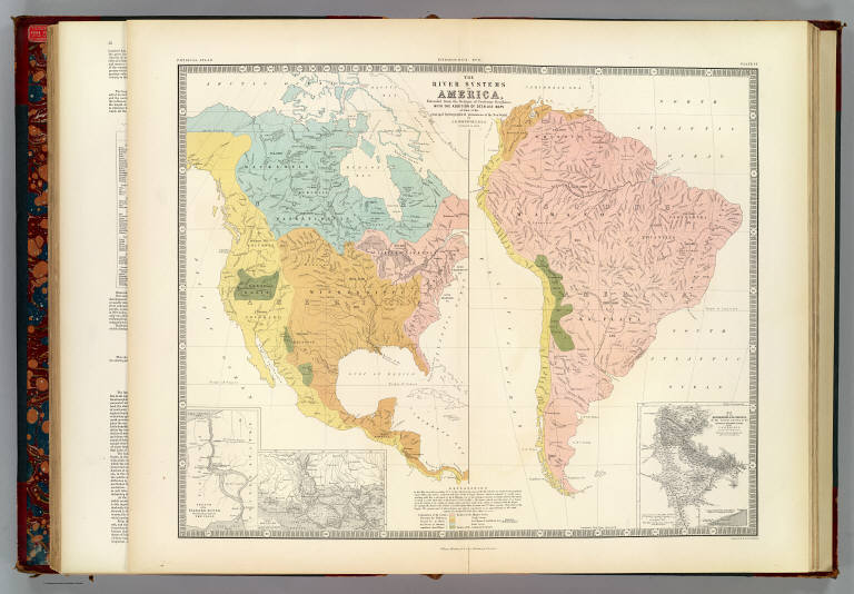
[Berghaus, Heinrich, Johnston, Alexander Keith, 1804-1871]
Full Title
The river systems of America, extended from the designs of Professor Berghaus, with additions of detailed maps of some of the principal hydrographical phenomena of the New World by A.K. Johnston, F.R.G.S. Corrected to 1855. Engraved by W. & A.K. Johnston. William Blackwood & Sons, Edinburgh & London. (1856)
List No
0372.018
Note
Two hand col. maps on 1 sheet. Inset maps: Sketch of the Niagara River showing the position of the Falls -- Delta of the Mississippi -- Map of the bifurcation of the Orinoco, or the natural junction of the Orinoco & Maranon rivers by the Casiquiare surveyed by A. von Humboldt. Scale 1:4,000,000. "Hydrology no. 6."
Author
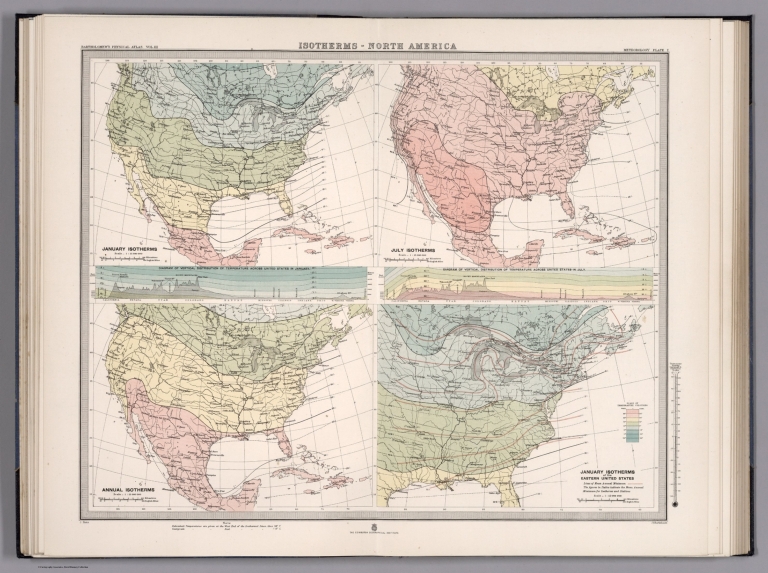
[Bartholomew, J.G., Hann, J.]
Full Title
Plate 7. Isotherms - North America.
List No
12430.017
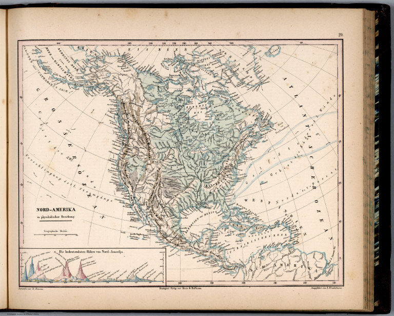
Author
Bromme, Traugott
Full Title
29. Nord-America in physikalischer Beziehung. Entworfen von Tr. Bromme. Ausgefuhrt v. E. Winckelmann. Stuttgart. Verlag von Krais & Hoffman. (to accompany) Atlas zur Physik der Welt. (with second title page) Atlas zu Alex. v. Humboldt's Kosmos ... Bromme. (with inset)
List No
1615.034
Note
Outline color map. With profile showing comparative heights of the mountains in North America. Relief shown by hachures.
Author
Bromme, Traugott
Full Title
30. Sud-America in physikalischer Beziehung. Entworfen von Tr. Bromme. Ausgefuhrt v. E. Winckelmann. Stuttgart. Verlag von Krais & Hoffman. (to accompany) Atlas zur Physik der Welt. (with second title page) Atlas zu Alex. v. Humboldt's Kosmos ... Bromme. (with inset)
List No
1615.035
Note
Outline color map. With profile showing comparative heights of the mountains in South America. Includes legend. Relief shown by hachures.
Author
Sargent, C.S.
Full Title
Map Showing the Position of the Forest, Prairie & Treeless Regions of North America exclusive of Mexico. Prepared under the direction of C.S. Sargent, Special Agent. (inset) Aleutian Islands. Julius Bien & Co. lith. N.Y. Compiled under the Direction of Henry Gannett, E.M. Harry King, Draughtsman.
List No
2332.002
Note
Date penciled on cover. Distribution of white ash and ponderosa or yellow pine. Relief shown in stippling. The Prairie category is less than 20% forested.
Author
Sargent, C.S.
Full Title
Map Showing the Natural Divisions of the North American Forests exclusive of Mexico. Prepared under the direction of C.S. Sargent, Special Agent. (inset) Aleutian Islands. Julius Bien & Co. lith. N.Y. Compiled under the Direction of Henry Gannett, E.M. Harry King, Draughtsman.
List No
2332.003
Note
Date penciled on cover. Relief shown in stippling. Forest categories: Pacific with Coast Pacific, and Interior Pacific; Northern; Northern Mexican; and Atlantic with Deciduous, Northern Pine, Coast Pine, Semi-Tropical.
Author
Sargent, C.S.
Full Title
Map Showing the Distribution of Genus Fraxinus [The Ashes] in North America exclusive of Mexico. Prepared under the direction of C.S. Sargent, Special Agent. (inset) Aleutian Islands. Julius Bien & Co. lith. N.Y. Compiled under the Direction of Henry Gannett, E.M. Harry King, Draughtsman.
List No
2332.004
Note
Date penciled on cover. Relief shown in stippling.
Author
Sargent, C.S.
Full Title
Map Showing the Distribution of the Genus Quercus [The Oaks.] in North America exclusive of Mexico. Prepared under the direction of C.S. Sargent, Special Agent. (inset) Aleutian Islands. Julius Bien & Co. lith. N.Y. Compiled under the Direction of Henry Gannett, E.M. Harry King, Draughtsman.
List No
2332.007
Note
Date penciled on cover. Relief shown in stippling.
Author
Sargent, C.S.
Full Title
Map Showing the Distribution of the Genus Pinus [The Pines.] in North America exclusive of Mexico. Prepared under the direction of C.S. Sargent, Special Agent. (inset) Aleutian Islands. Julius Bien & Co. lith. N.Y. Compiled under the Direction of Henry Gannett, E.M. Harry King, Draughtsman.
List No
2332.009
Note
Date penciled on cover. Relief shown in stippling.
Author
Sargent, C.S.
Full Title
Map Showing the Distribution of the Genus Abies & Picea [The Firs & Spruces] in North America exclusive of Mexico. Prepared under the direction of C.S. Sargent, Special Agent. (inset) Aleutian Islands. Julius Bien & Co. lith. N.Y. Compiled under the Direction of Henry Gannett, E.M. Harry King, Draughtsman.
List No
2332.010
Note
Date penciled on cover. Relief shown in stippling.
Author
Sargent, C.S.
Full Title
Map Showing the Distribution of Fraxinus Americana & Pinus Ponderosa in North America exclusive of Mexico. Prepared under the direction of C.S. Sargent, Special Agent. (inset) Aleutian Islands. Julius Bien & Co. lith. N.Y. Compiled under the Direction of Henry Gannett, E.M. Harry King, Draughtsman.
List No
2332.013
Note
Date penciled on cover. Distribution of white or American ash, and yellow or ponderosa pine. Relief shown in stippling.
Author
Sargent, C.S.
Full Title
Map Showing the Distribution of the Genera Chamaecyparis & Cupressus in North America exclusive of Mexico. Prepared under the direction of C.S. Sargent, Special Agent. (inset) Aleutian Islands. Julius Bien & Co. lith. N.Y. Compiled under the Direction of Henry Gannett, E.M. Harry King, Draughtsman.
List No
2332.014
Note
Date penciled on cover. Distribution of cypresses. Relief shown in stippling.
Author
Sargent, C.S.
Full Title
Map Showing the Distribution of the Genera Thuya, Taxodium and Sequoia in North America exclusive of Mexico. Prepared under the direction of C.S. Sargent, Special Agent. (inset) Aleutian Islands. Julius Bien & Co. lith. N.Y. Compiled under the Direction of Henry Gannett, E.M. Harry King, Draughtsman.
List No
2332.015
Note
Date penciled on cover. Distribution of cypruses, and redwoods. Relief shown in stippling.
Author
Sargent, C.S.
Full Title
Map Showing the Distribution of Pinus Strobus, P. (Pinus) Palustris, and Pseudotsuga Douglasii in North America exclusive of Mexico. Prepared under the direction of C.S. Sargent, Special Agent. (inset) Aleutian Islands. Julius Bien & Co. lith. N.Y. Compiled under the Direction of Henry Gannett, E.M. Harry King, Draughtsman.
List No
2332.016
Note
Date penciled on cover. Distribution of eastern white pine, longleaf pine, and Douglas fir. Relief shown in stippling.
Author
Prichard, James Cowles
Full Title
Ethnographical Map of North America, in the Earliest Times, Illustrative of Dr. Pritchard's Natural History of Man and His Researches into the Physical History of Mankind. Second Edition - 1861.
List No
4011.007
Note
Relief shown by hachures. Hand colored. Twenty-three races and peoples shown.
Author
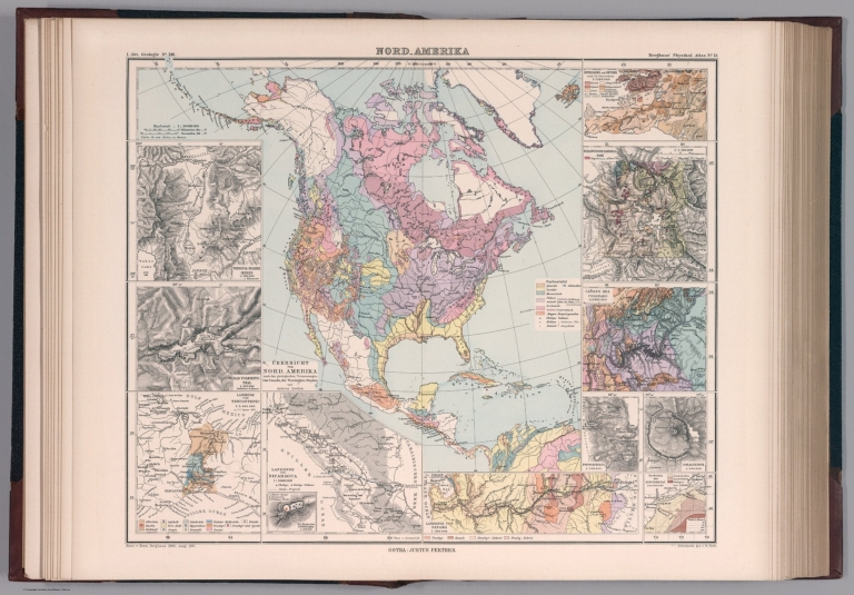
[Berghaus, Heinrich, Berghaus, Hermann, Risch, M.]
Full Title
Nord-Amerika. Ubersicht von Nord-Amerika. Entw. v. Herm. Berghaus 1886, Ausg. 1887. Nebenkarten gez. v. M. Risch. Gotha: Justus Perthes. (On upper margin) I. Abt. Geologie No. XIII. Berghaus' physikal atlas No. 13. (to Accompany) Berghaus' Physikalischer Atlas. (Begrundet 1836 durch Heinrich Berghaus) ... Gotha: Justus Perthes. 1892. (12 insets).
List No
4391.023
Note
Color lithograph map. Insets: Virginia-Silber-Minen -- Das Yosemite-Thal -- Landenge von Tehuantepec -- Landenge von Nicaragua -- Die Krater des Turrialba -- Landenge von Panama -- Seeboden der New-York-Bay -- Popocatepetl -- Citlaltepetl -- Canons des Colorado --Yellowstone-National -Park -- Reykjanes und Geyser. Showing major cities, towns, rivers and river basins. Principal geological features are shown by color or symbols. Relief shown by contours and spot heights. Depth shown by isolines and soundings. Includes table. Prime meridian is Greenwich.
Author
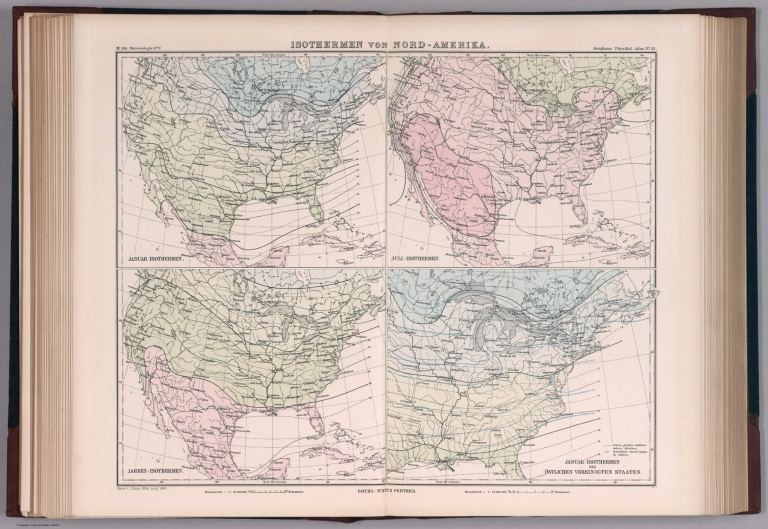
[Berghaus, Heinrich, Hann, Julius]
Full Title
Isothermen von Nord - Amerika. Janur - Isothermen. Juli - Isothermen. Jahres - Isothermen. Janur - Isothermen der Ostlichen vereinigten staaten. Entw. v. J. Hann 1884, Ausg. 1887. Gotha: Justus Perthes. (On upper margin) III. Abt. Meteorologie No. V. Berghaus' physikal atlas No. 31. Atlas der Meteorologie. (Berghaus' physikalischer atlas, Abteilung III). (to Accompany) Berghaus' Physikalischer Atlas. (Begrundet 1836 durch Heinrich Berghaus) ... Gotha: Justus Perthes. 1892.
List No
4391.051
Note
4 color climatological maps of North America on 1 sheet. Showing typical temperature patterns for a year, months of January and July and eastern United States. Isothermal lines indicate equal temperature at a given time or on average over a given period. Map shows boundaries and regions. Includes explanation table. Prime meridian is Greenwich.
1-28 of 28
|


![Distribution of Genus Fraxinus [The Ashes] in North America.](https://www.davidrumsey.com/rumsey/Size2/D5005/2332004.jpg)
![Distribution of the Genus Quercus [The Oaks.] in North America.](https://www.davidrumsey.com/rumsey/Size2/D5005/2332007.jpg)
![Distribution of the Genus Pinus [The Pines.] in North America.](https://www.davidrumsey.com/rumsey/Size2/D5005/2332009.jpg)
![Distribution of the Genus Abies & Picea [The Firs & Spruces] in North America.](https://www.davidrumsey.com/rumsey/Size2/D5005/2332010.jpg)