|
REFINE
Browse All : Physical Atlas from 1854
1-13 of 13
Author
Johnston, Alexander Keith, 1804-1871
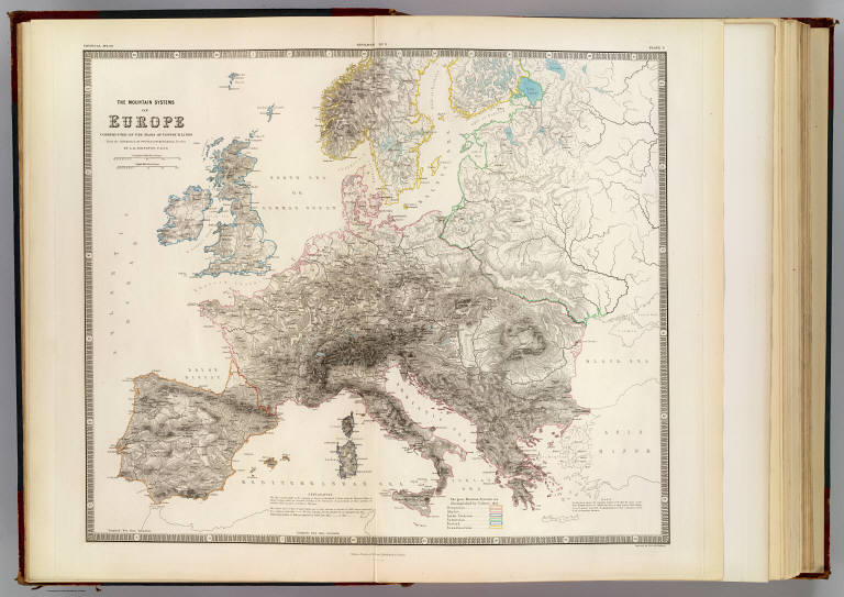
Full Title
The mountain systems of Europe constructed on the basis of contour lines. From the drawings of Professor Berghaus, Berlin. By A.K. Johnston, F.R.S.E. Engraved by W. & A.K. Johnston. William Blackwood & Sons, Edinburgh & London. 1st. Nov. 1854, (1856)
List No
0372.003
Note
Hand col. lithographed map. Relief shown by contours and hachures. 6 mountain systems outlined in color. "Geology no. 3."
Forbes, Edward, 1815-1854; Johnston, Ale... Geological, palaeontological map British... 1854 0372.005 Related Author
[Forbes, Edward, 1815-1854, Johnston, Alexander Keith, 1804-1871]
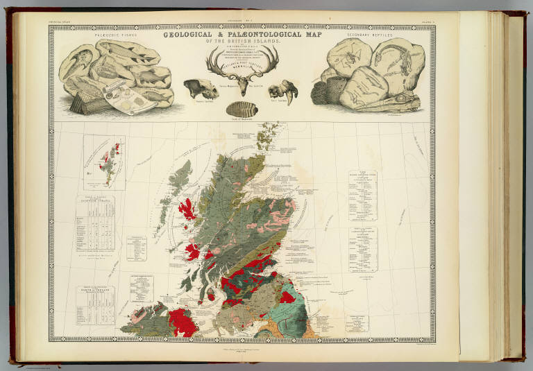
Full Title
Geological & palaeontological map of the British Islands. By A.K. Johnston, F.R.G.S. From the sketches & notes of Professor Edward Forbes, F.R.S. of Kings College London & of the Government School of Mines, President of the Geological Society. Engraved by W. & A.K. Johnston. William Blackwood & Sons, Edinburgh & London. 1st March 1854, (1856)
List No
0372.005
Note
Col. lithographed map. Northern half covering Scotland and parts of Ireland, Northern Ireland and England. Explanation on pl. 6. Includes inset of the Shetland Islands, tables, and illustrations of "Palaeozoic fishes," "Tertiary & post Tertiary Mamallia," and "Secondary reptiles." "Geology no. 5."
Forbes, Edward, 1815-1854; Johnston, Ale... Palaeontological map (British Islands). 1854 0372.006 Related Author
[Forbes, Edward, 1815-1854, Johnston, Alexander Keith, 1804-1871]
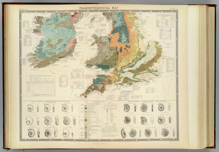
Full Title
Palaeontological map (British Islands. By A.K. Johnston, F.R.G.S. From the sketches & notes of Professor Edward Forbes, F.R.S. of Kings College London & of the Government School of Mines, President of the Geological Society). Engraved by W. & A.K. Johnston. William Blackwood & Sons, Edinburgh & London. 1st March 1854, (1856)
List No
0372.006
Note
Col. lithographed map. Southern half of "Geological & palaeontological map of the British Islands." Covers Wales and most of England and Ireland. Shows 25 geologic units. Includes notes, tables and illustrations: Types of groups of Ammonites ... after Von Buch & D'Orbigny." "Geology no. 6."
Forbes, Edward, 1815-1854; Johnston, Ale... Composite: Geological, palaeontological ... 1854 0372.007 Related Author
[Forbes, Edward, 1815-1854, Johnston, Alexander Keith, 1804-1871]
Full Title
(Composite of) Geological & palaeontological map of the British Islands. By A.K. Johnston, F.R.G.S. From the sketches & notes of Professor Edward Forbes, F.R.S. of Kings College London & of the Government School of Mines, President of the Geological Society. Engraved by W. & A.K. Johnston. William Blackwood & Sons, Edinburgh & London. 1st March 1854, (1856)
List No
0372.007
Note
Col. lithographed map on 2 sheets. Southern sheet entitled: Palaeontological map. Shows 25 geologic units. Includes inset of the Shetland Islands, notes, tables, and illustrations of "Palaeozoic fishes," "Tertiary & post Tertiary Mamallia," and "Secondary reptiles, " and "Types of groups of Ammonites ... after Von Buch & D'Orbigny." "Geology no. 5. ... no. 6."
Author
[Charpentier, Jean de, 1786-1855, Forbes, Edward, 1815-1854, Johnston, Alexander Keith, 1804-1871]
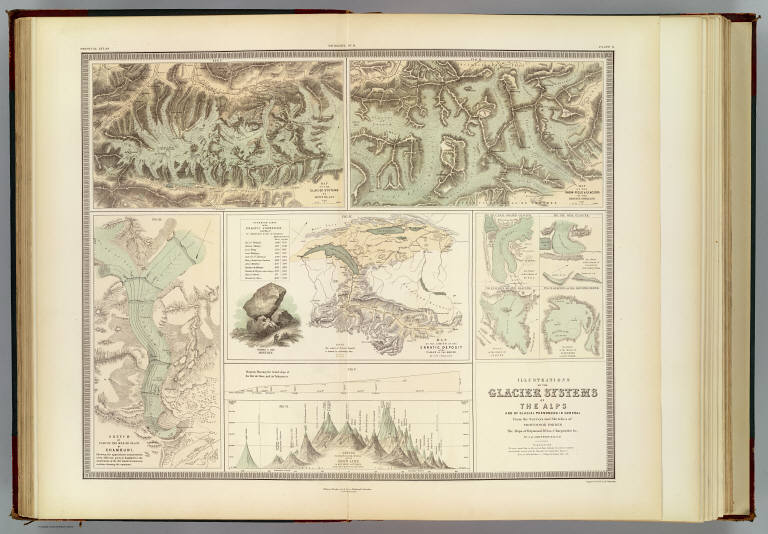
Full Title
Illustrations of the glacier systems of the Alps and of glacial phenomena in general. From the surveys and sketches of Professor Forbes, the maps of Raymond, Weiss, Charpentier &c., by A.K. Johnston, F.R.S.E. Engraved by W. & A.K. Johnston. William Blackwood & Sons, Edinburgh & London. 1st. November 1854. (1856)
List No
0372.010
Note
Four col. maps on 1 sheet. Includes 4 inset maps and 2 diagrams. Contents: Map of the glacier system of Mont Blanc. Scale (ca. 1:120,000) -- Map of the snow-field glaciers of the Bernese Oberland. Scale (ca. 1:120,000) -- Sketch of part of the Mer de Glace of Chamouni -- Map of the limits of the erratic deposit of the valley of the Rhone by J. de Charpentier -- Eye sketch of the glacier of Miace -- Eye sketch of the glacier of Allalein in the valley of Saas -- Sketch of the glacier of Talefre -- Eye sketch of the glacier of Schonhorn near the Simplon -- Sketch showing the actual elevation of the snow line in different latitudes from the Equator to the poles -- Diagram showing the actual slope of the Mer de Glace, and its tributaries. "Geology no. 9."
Author
[Johnston, Alexander Keith, 1804-1871, Russell, J. Scott (John Scott), 1808-1882]
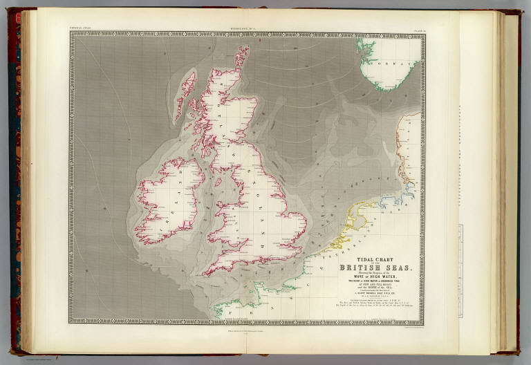
Full Title
Tidal chart of the British Seas. Showing the progress of the wave of high water, the hour of high water in Greenwich time at new and full moon; and the depth of the sea. Constructed under the direction of J. Scott Russell, Esqr., F.R.S., ED. by A.K. Johnston, F.R.G.S. Engraved by W. & A.K. Johnston. William Blackwood & Sons, Edinburgh & London. 1 Nov. 1854. (1856)
List No
0372.016
Note
Hand col. lithograph. Depths shown by bathymetric tints. "Hydrology no. 4."
Author
Johnston, Alexander Keith, 1804-1871
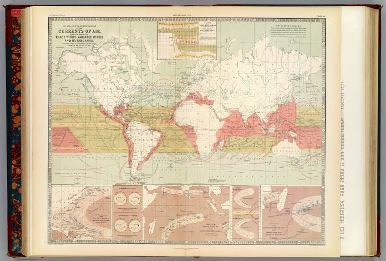
Full Title
Geographical distribution of the currents of air, showing the regions of the trade winds, variable winds and hurricanes, with their effects in determining the different tracks of navigation by A.K. Johnston, F.R.S.E. Engraved & printed in colours by W. & A.K. Johnston, Edinburgh. William Blackwood & Sons, Edinburgh & London. 1st. March 1854. (1856)
List No
0372.020
Note
Col. lithographed map. Inset maps: Limits of the trade winds & calms in the Atlantic Ocean between longitude 200E & 800W as determined by the wind & current charts of Lieut. Maury, U.S.N. -- The stormy regions of the West Indies showing the tracks of various hurricanes -- Tracks of the Madras Storm, 1842 and the Rodriguez Hurricane, 1843, from observations by Mr. Piddington & Mr. Thom -- Chart of the Culloden's Hurricane, 1809 and the Boyne's Gale, 1835 by Lieut. Col. W. Reid, R.E. Inset illustrations: Barometrical compass -- Thermometrical compass -- Hurricanes of the N. Hemisphere -- Hurricanes of the S. Hemisphere. "Meteorology no. 2."
Author
Johnston, Alexander Keith, 1804-1871
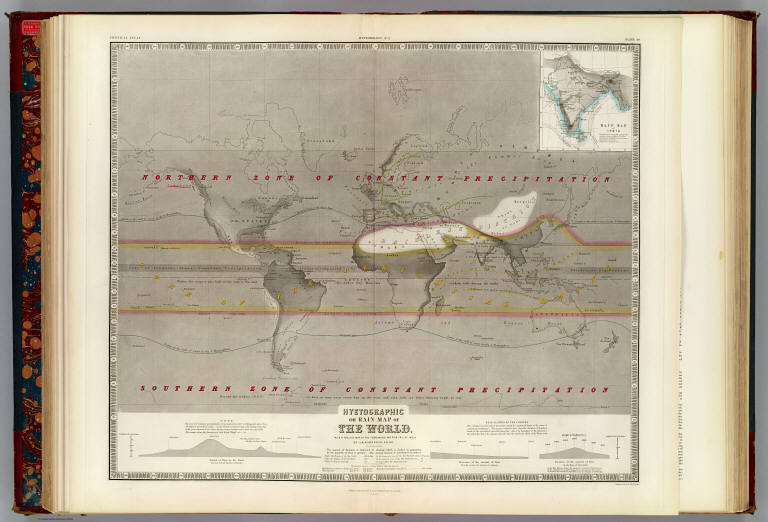
Full Title
Hyetographic or rain map of the World, with a special map of the temperature and rain fall of India by A.K. Johnston, F.R.S.E. Engraved by W. & A.K. Johnston. William Blackwood & Sons, Edinburgh & London. 1st. June 1854. (1856)
List No
0372.021
Note
Col. lithographed map. Inset: Rain map of India. Scale [ca. 1:32,000,000] . Inset charts: Amount of rain in the zones, decrease from the Equator to the poles -- Decrease of the amount of rain from the coasts to the interior of continents -- Increase of the amount of rain on the slopes of mountains. "Meteorology no. 3."
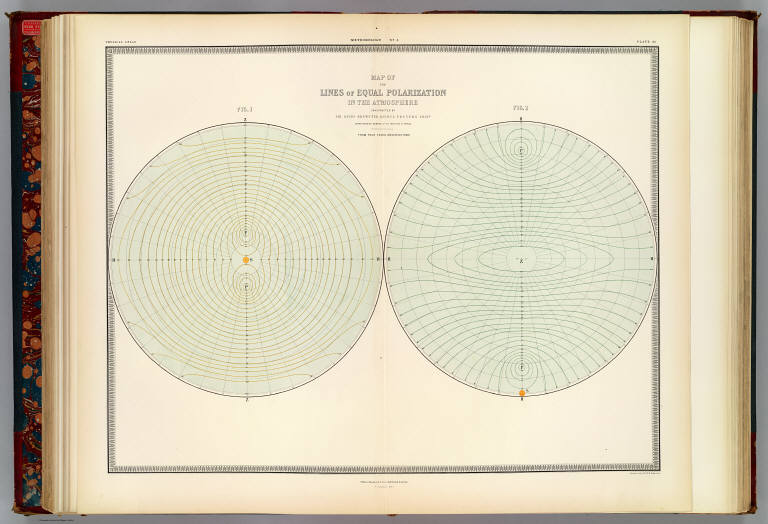
Author
Brewster, David, Sir, 1781-1868
Full Title
Map of the lines of equal polarization in the atmosphere constructed by Sir David Brewster, K.H., D.C.L., F.R.S., V.P.R.S., Edinr., corresponding member of the Institute of France. From four years observations. Engraved by W. & A.K. Johnston. William Blackwood & Sons, Edinburgh & London. 1st. March 1854, (1856)
List No
0372.023
Note
Col. lithographed map in 2 hemispheres. "Meteorology no. 5."
Author
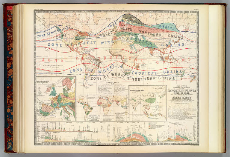
[Henfrey, Arthur, 1819-1859, Johnston, Alexander Keith, 1804-1871]
Full Title
Map of the geographical distribution of the most important plants yielding food, including the cultivated grains and other cultivated and wild bread plants with indications of the principal fruits; laid down in connection with climatal conditions for Keith Johnston's Physical atlas by Arthur Henfrey, F.R.S; F.L.S. &c. Engraved & printed in colours by W. & A.K. Johnston, Edinburgh. William Blackwood & Sons, Edinburgh & London. 1st. March 1854, (1856)
List No
0372.025
Note
Col. lithographed map. Insets: Map of the distribution of the principal food plants, fruits & characteristic trees of Western & Central Europe -- Map of the distribution of the more important plants, yielding materials for beverages, spices, dyes, and other economical substances; and growing in the warmer regions of the globe -- Map of the distribution of tea & the principal spices grown in the East Indies -- Two sections from S. to N. in Western & Central Europe, showing the distribution of the principal food plants according to altitude -- Two sections showing approximatively the distribution of the most important economical plants according to altitude, Western Hemisphere, Eastern Hemisphere. "Phytology & zoology no. 1."
Author
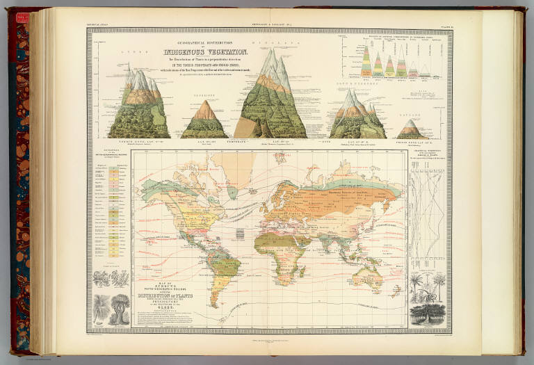
[Henfrey, Arthur, 1819-1859, Johnston, Alexander Keith, 1804-1871, Schouw, Joakim Frederik, 1789-1852]
Full Title
Geographical distribution of indigenous vegetation. The distribution of plants in a perpendicular direction in the torrid, temperate and frigid zones, with indications of the mean temperature of the year and of the coldest and warmest months by A.K. Johnston, F.R.S.E. & Arthur Henfrey, F.R.S., E.L.S. &c. Map of Schouws phyto-geographic regions with the distribution of plants especially influencing the physiognomy of the vegetation of the globe. Engraved & printed in colours by W. & A.K. Johnston, Edinburgh. William Blackwood & Sons, Edinburgh & London. 1st. May 1854, (1856)
List No
0372.026
Note
Col. lithograph. Illustration of "The distribution of plants in a perpendicular direction ..." shows the Andes, Teneriffe, Himalaya, Alps & Pyrenees and Lapland. Inset charts: Regions of altitude corresponding to isothermal zones -- Graphical statistics of the most important families of plants. Includes drawings of plants and plant parts. "Phytology & zoology no. 2."
Author
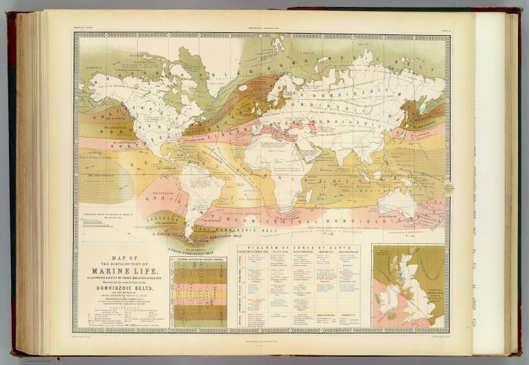
[Forbes, Edward, 1815-1854, Johnston, Alexander Keith, 1804-1871]
Full Title
Map of the distribution of marine life, illustrated chiefly by fishes, Molluscs & Radiata; showing also the extent & limits of the Homoiozoic belts, now first laid down for Keith Johnston's Physical atlas by Professor Edward Forbes, F.R.S., of Kings College, London & the Government School of Mines, President of the Geological Society. Engraved & printed in colours by W. & A.K. Johnston, Edinr. William Blackwood & Sons, Edinburgh & London. 1st March 1854, (1856)
List No
0372.032
Note
Col. lithographed map. Includes map "Colonization of British Seas illustrated by Mollusca & Radiata," "Diagram illustrating generic centres," "Diagram of zones of depth," and graph "Comparative extent of regions of depth in the Aegean Sea." "Phytology & zoology no. 8."
Author
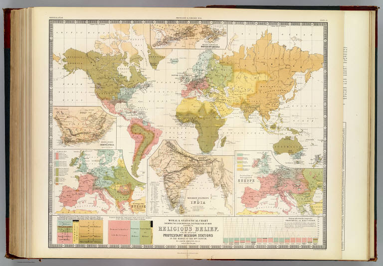
Johnston, Alexander Keith, 1804-1871
Full Title
Moral & statistical chart showing the geographical distribution of man according to religious belief, with the principal Protestant mission stations in the middle of the 19th century. By A. Keith Johnston, F.R.S.E. Engraved & printed in colours by W. & A.K. Johnston, Edinburgh. William Blackwood & Sons, Edinburgh & London. 1st May, 1854. (1856)
List No
0372.035
Note
Col. lithographed map. Inset maps: Distribution of man in Europe according to language. Scale [ca. 1:17,000,000] -- Mission stations of India. Scale [ca. 1:20,500,000] -- Prevailing forms of religion in Europe. Scale [ca. 1:17,000,000] -- Mission stations of British Nth. America -- Missions stations of South Africa. Includes statistical charts of population by religion and school enrollment. "Phytology & zoology no. 11."
1-13 of 13
|