|
Author
Yaggy, Levi Walter
Full Title
Topography of the United States of America.
List No
10096.010
Author
Yaggy, Levi Walter
Full Title
(Covers to) Yaggy's Geographical Study Comprising Physical, Political, Geological, and Astronomical Geography. Published by Western Publishing House. Chicago. Copyrighted 1887.
List No
10200.001
Note
The covers were constructed to act as both storage for the charts and as a tilt-up easel to hold the charts for viewing.
Author
Yaggy, Levi Walter
Full Title
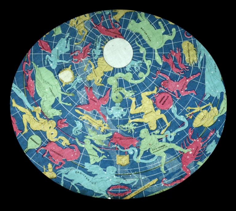
Planetary System... (Flap open showing) Chart of the Heavens.
List No
10200.005
Note
Center flap open showing the Chart of the Heavens.
Author
Yaggy, Levi Walter
Full Title
(backlit) Planetary System... (Flap open showing) Chart of the Heavens.
List No
10200.006
Note
Center flap open showing the Chart of the Heavens.
Author
Yaggy, Levi Walter
Full Title
Video showing progression of the night sky in the Chart of the Heavens.
List No
10200.007
Author
Yaggy, Levi Walter
Full Title
Planetary System... (Flap open showing) Phases of the Moon.
List No
10200.008
Author
Yaggy, Levi Walter
Full Title
(backlit) Planetary System... (Flap open showing) Phases of the Moon.
List No
10200.009
Author
Yaggy, Levi Walter
Full Title
Planetary System... (Flap open showing) A Movable Diagram Showing the Succession of Day and Night.
List No
10200.010
Author
Yaggy, Levi Walter
Full Title
(backlit) Planetary System... (Flap open showing) A Movable Diagram Showing the Succession of Day and Night.
List No
10200.011
Author
Yaggy, Levi Walter
Full Title
Planetary System... (Flap open showing) Moon as Seen Through the Largest Telescope.
List No
10200.012
Author
Yaggy, Levi Walter
Full Title
(backlit) Planetary System... (Flap open showing) Moon as Seen Through the Largest Telescope.
List No
10200.013
Author
Yaggy, Levi Walter
Full Title
Planetary System... (Flap open showing) The Change of Seasons.
List No
10200.014
Author
Yaggy, Levi Walter
Full Title
(backlit) Planetary System... (Flap open showing) The Change of Seasons.
List No
10200.015
Author
Yaggy, Levi Walter
Full Title
The Five Zones Showing in a Graphic Manner the Climates, Peoples, Industries & Productions of The Earth.
List No
10200.018
Author
Yaggy, Levi Walter
Full Title
Physical Geography. (Flap open showing the typical physical features of the earth's surface).
List No
10200.019
Author
Yaggy, Levi Walter
Full Title
Physical Geography. (Flap open showing the typical physical features under the earth's surface).
List No
10200.020
Author
Yaggy, Levi Walter
Full Title
Physical Geography. (Flap open showing typical physical features and fish under the seas).
List No
10200.021
Author
Yaggy, Levi Walter
Full Title
Relief Map of the United States. Constructed under the Supervision of Henry Gannett Chief Geographer U.S. Vertical Exaggeration 15 inches to 1 inch horizontal. Copyrighted 1887.
List No
10200.023
Author
Yaggy, Levi Walter
Full Title
(Verso) Planetary System.
List No
10200.024
Note
Shows the openings that enable the backlit views.
Author
U.S. Navy
Full Title
(Covers to) Ice Atlas of the Northern Hemisphere.
List No
1103A
Note
Comb bound with black cloth boards embossed on the front with the Northern Hemisphere in polar projection and gilt lettering, "Ice Atlas of the Northern Hemisphere."
Author
U.S. Navy
Full Title
(Index (Lining) to) Ice Atlas of the Northern Hemisphere.
List No
1103.001
Author
U.S. Navy
Full Title
(Index (Lining) to) Ice Atlas of the Northern Hemisphere.
List No
1103B
Author
U.S. Navy
Full Title
(Index (Lining) to) Ice Atlas of the Northern Hemisphere.
List No
1103C
Author
U.S. Navy
Full Title
(Text Page) Preface: Ice Atlas of the Northern Hemisphere.
List No
1103D
Note
Describes the contributions of Dr. John C. Weaver, Mr. S.W. Boggs, Mr. C.B. Hitchcock, and Dr. L.M. Gould to the compilation of this volume. Explains many aspects of the atlas and ice. Notes that the bibliography contains 1700 references, many of which provide more detail on specific areas.
Author
U.S. Navy
Full Title
(Section Title Page) Northern Hemisphere Sea Ice.
List No
1103E
Author
U.S. Navy
Full Title
Ice Chart, Northern Hemisphere, January.
List No
1103.002
Note
Shows five types of ice: permanent polar pack, unnavigable sea and land-fast ice, icebreaker penetrable, navigable by heavily built vessels, and navigable by unreinforced vessels. Shows extent of ice by average extent, extremes, vicinity of icebergs and/or growlers, and exceptional positions. Scales shown by direction (north-south, east-west, and diagonal) for various latitudes.
Author
U.S. Navy
Full Title
Ice Chart, Northern Hemisphere, February.
List No
1103.003
Note
Shows five types of ice: permanent polar pack, unnavigable sea and land-fast ice, icebreaker penetrable, navigable by heavily built vessels, and navigable by unreinforced vessels. Shows extent of ice by average extent, extremes, vicinity of icebergs and/or growlers, and exceptional positions. Scales shown by direction (north-south, east-west, and diagonal) for various latitudes.
Author
U.S. Navy
Full Title
Ice Chart, Northern Hemisphere, March.
List No
1103.004
Note
Shows five types of ice: permanent polar pack, unnavigable sea and land-fast ice, icebreaker penetrable, navigable by heavily built vessels, and navigable by unreinforced vessels. Shows extent of ice by average extent, extremes, vicinity of icebergs and/or growlers, and exceptional positions. Scales shown by direction (north-south, east-west, and diagonal) for various latitudes.
Author
U.S. Navy
Full Title
Ice Chart, Northern Hemisphere, April.
List No
1103.005
Note
Shows five types of ice: permanent polar pack, unnavigable sea and land-fast ice, icebreaker penetrable, navigable by heavily built vessels, and navigable by unreinforced vessels. Shows extent of ice by average extent, extremes, vicinity of icebergs and/or growlers, and exceptional positions. Scales shown by direction (north-south, east-west, and diagonal) for various latitudes.
Author
U.S. Navy
Full Title
Ice Chart, Northern Hemisphere, May.
List No
1103.006
Note
Shows five types of ice: permanent polar pack, unnavigable sea and land-fast ice, icebreaker penetrable, navigable by heavily built vessels, and navigable by unreinforced vessels. Shows extent of ice by average extent, extremes, vicinity of icebergs and/or growlers, and exceptional positions. Scales shown by direction (north-south, east-west, and diagonal) for various latitudes.
Author
U.S. Navy
Full Title
Ice Chart, Northern Hemisphere, June.
List No
1103.007
Note
Shows five types of ice: permanent polar pack, unnavigable sea and land-fast ice, icebreaker penetrable, navigable by heavily built vessels, and navigable by unreinforced vessels. Shows extent of ice by average extent, extremes, vicinity of icebergs and/or growlers, and exceptional positions. Scales shown by direction (north-south, east-west, and diagonal) for various latitudes.
Author
U.S. Navy
Full Title
Ice Chart, Northern Hemisphere, July.
List No
1103.008
Note
Shows five types of ice: permanent polar pack, unnavigable sea and land-fast ice, icebreaker penetrable, navigable by heavily built vessels, and navigable by unreinforced vessels. Shows extent of ice by average extent, extremes, vicinity of icebergs and/or growlers, and exceptional positions. Scales shown by direction (north-south, east-west, and diagonal) for various latitudes.
Author
U.S. Navy
Full Title
Ice Chart, Northern Hemisphere, August.
List No
1103.009
Note
Shows five types of ice: permanent polar pack, unnavigable sea and land-fast ice, icebreaker penetrable, navigable by heavily built vessels, and navigable by unreinforced vessels. Shows extent of ice by average extent, extremes, vicinity of icebergs and/or growlers, and exceptional positions. Scales shown by direction (north-south, east-west, and diagonal) for various latitudes.
Author
U.S. Navy
Full Title
Ice Chart, Northern Hemisphere, September.
List No
1103.010
Note
Shows five types of ice: permanent polar pack, unnavigable sea and land-fast ice, icebreaker penetrable, navigable by heavily built vessels, and navigable by unreinforced vessels. Shows extent of ice by average extent, extremes, vicinity of icebergs and/or growlers, and exceptional positions. Scales shown by direction (north-south, east-west, and diagonal) for various latitudes.
Author
U.S. Navy
Full Title
Ice Chart, Northern Hemisphere, October.
List No
1103.011
Note
Shows five types of ice: permanent polar pack, unnavigable sea and land-fast ice, icebreaker penetrable, navigable by heavily built vessels, and navigable by unreinforced vessels. Shows extent of ice by average extent, extremes, vicinity of icebergs and/or growlers, and exceptional positions. Scales shown by direction (north-south, east-west, and diagonal) for various latitudes.
Author
U.S. Navy
Full Title
Ice Chart, Northern Hemisphere, November.
List No
1103.012
Note
Shows five types of ice: permanent polar pack, unnavigable sea and land-fast ice, icebreaker penetrable, navigable by heavily built vessels, and navigable by unreinforced vessels. Shows extent of ice by average extent, extremes, vicinity of icebergs and/or growlers, and exceptional positions. Scales shown by direction (north-south, east-west, and diagonal) for various latitudes.
Author
U.S. Navy
Full Title
Ice Chart, Northern Hemisphere, December.
List No
1103.013
Note
Shows five types of ice: permanent polar pack, unnavigable sea and land-fast ice, icebreaker penetrable, navigable by heavily built vessels, and navigable by unreinforced vessels. Shows extent of ice by average extent, extremes, vicinity of icebergs and/or growlers, and exceptional positions. Scales shown by direction (north-south, east-west, and diagonal) for various latitudes.
Author
U.S. Navy
Full Title
Extreme Limits of Ice, 1998 - 1938, April - August
List No
1103.014
Note
Shows five types of ice: permanent polar pack, unnavigable sea and land-fast ice, icebreaker penetrable, navigable by heavily built vessels, and navigable by unreinforced vessels. Shows extent of ice by average extent, extremes, vicinity of icebergs and/or growlers, and exceptional positions. Scales shown by direction (north-south, east-west, and diagonal) for various latitudes.
Author
U.S. Navy
Full Title
(Section Title Page) Northern Hemisphere River Ice
List No
1103F
Author
U.S. Navy
Full Title
River Ice in Relation to Navigation, Closing Dates.
List No
1103.015
Author
U.S. Navy
Full Title
River Ice in Relation to Navigation, Opening Dates.
List No
1103.016
Author
U.S. Navy
Full Title
River Ice in Relation to Navigation, Average Annual Number of Days with Ice.
List No
1103.017
Author
U.S. Navy
Full Title
(Section Title Page) Grand Banks Region.
List No
1103G
Author
U.S. Navy
Full Title
Grand Banks Region, Index Chart for Ice Data Tables
List No
1103.018
Author
U.S. Navy
Full Title
(Text Page) Ice Data Tables, Grand Banks Region.
List No
1103H
Author
U.S. Navy
Full Title
(Text Page) Ice Data Tables (continued), Grand Banks Region.
List No
1103I
Author
U.S. Navy
Full Title
Ice Chart, Grand Banks Region, January.
List No
1103.019
Author
U.S. Navy
Full Title
Ice Chart, Grand Banks Region, February.
List No
1103.020
Author
U.S. Navy
Full Title
Ice Chart, Grand Banks Region, March.
List No
1103.021
Author
U.S. Navy
Full Title
Ice Chart, Grand Banks Region, April.
List No
1103.022
|