|
Author
Cartee, Cornelius S.
Full Title
(Covers to) A School Atlas Of Physical Geography, Illustrating, In A Series Of Maps Compiled From The Celebrated Atlas Of A. Keith Johnston, And Of Milner And Petermann, The Elementary Facts Of Geology, Hydrology, Meteorology, And Natural History; And Designed To Accompany Cartee's "Elements Of Physical Geography." By Cornelius S. Cartee, A.M. Boston: Hickling, Swan, And Brown. M DCCC LVI. (on verso) Entered ... 1856, by Hickling, Swan, And Brown ... Massachusetts.
List No
0129.001
Note
Most of the maps are in full hand painted color; one has outline color and one is uncolored. Covers are quarter leather green cloth covered boards with "Cartee's Physical Atlas." stamped in gilt.
Author
Cartee, Cornelius S.
Full Title
(Title Pages to) A School Atlas Of Physical Geography, Illustrating, In A Series Of Maps Compiled From The Celebrated Atlas Of A. Keith Johnston, And Of Milner And Petermann, The Elementary Facts Of Geology, Hydrology, Meteorology, And Natural History; And Designed To Accompany Cartee's "Elements Of Physical Geography." By Cornelius S. Cartee, A.M. Boston: Hickling, Swan, And Brown. M DCCC LVI. (on verso) Entered ... 1856, by Hickling, Swan, And Brown ... Massachusetts.
List No
0129.002
Note
Most of the maps are in full hand painted color; one has outline color and one is uncolored. Covers are quarter leather green cloth covered boards with "Cartee's Physical Atlas." stamped in gilt.
Author
Cartee, Cornelius S.
Full Title
(Text Page to) Editor's Preface. (by) C.S. Cartee. (to accompany) A School Atlas Of Physical Geography, Illustrating, In A Series Of Maps Compiled From The Celebrated Atlas Of A. Keith Johnston, And Of Milner And Petermann, The Elementary Facts Of Geology, Hydrology, Meteorology, And Natural History; And Designed To Accompany Cartee's "Elements Of Physical Geography." By Cornelius S. Cartee, A.M. Boston: Hickling, Swan, And Brown. M DCCC LVI. (on verso) Entered ... 1856, by Hickling, Swan, And Brown ... Massachusetts.
List No
0129.003
Note
Most of the maps are in full hand painted color; one has outline color and one is uncolored. Covers are quarter leather green cloth covered boards with "Cartee's Physical Atlas." stamped in gilt.
Author
Cartee, Cornelius S.
Full Title
(Contents to) A School Atlas Of Physical Geography, Illustrating, In A Series Of Maps Compiled From The Celebrated Atlas Of A. Keith Johnston, And Of Milner And Petermann, The Elementary Facts Of Geology, Hydrology, Meteorology, And Natural History; And Designed To Accompany Cartee's "Elements Of Physical Geography." By Cornelius S. Cartee, A.M. Boston: Hickling, Swan, And Brown. M DCCC LVI. (on verso) Entered ... 1856, by Hickling, Swan, And Brown ... Massachusetts.
List No
0129.004
Note
Most of the maps are in full hand painted color; one has outline color and one is uncolored. Covers are quarter leather green cloth covered boards with "Cartee's Physical Atlas." stamped in gilt.
Author
Cartee, Cornelius S.
Full Title
The World in Hemispheres. Designed To Accompany Cartee's "Elements Of Physical Geography. Engraved by G.W. Boynton. (to accompany) A School Atlas Of Physical Geography ... By Cornelius S. Cartee, A.M. M DCCC LVI. (with inset drawings).
List No
0129.005
Note
Hand color map. Covers the entire world with color coding according to continents. Includes inset drawings of comparative river lengths and mountain heights. With note: "The heights of mountains &c. indicated by scale of English feet, on the margin of map. The length of rivers is stated in English miles under the names". Also includes inset drawings of American, European, African and Asiatic cites, and American, European and Asian waterfalls, with note indicating list of waterfalls. Relief shown by hachures.
Author
Cartee, Cornelius S.
Full Title
Map of North America. Designed To Accompany Cartee's "Elements Of Physical Geography. Engraved by G.W. Boynton. Entered ... 1856, by Hickling, Swan, And Brown ... Massachusetts. (to accompany) A School Atlas Of Physical Geography ... By Cornelius S. Cartee, A.M. M DCCC LVI.
List No
0129.006
Note
Hand color map. Includes explanation. Shows regions, cities, rivers. Relief shown by hachures and spot heights. Prime meridian is Greenwich.
Author
Cartee, Cornelius S.
Full Title
Map of South America. Designed To Accompany Cartee's "Elements Of Physical Geography. Engraved by G.W. Boynton. Entered ... 1856, by Hickling, Swan, And Brown ... Massachusetts. (to accompany) A School Atlas Of Physical Geography ... By Cornelius S. Cartee, A.M. M DCCC LVI.
List No
0129.007
Note
Hand color map. Includes explanation. Shows regions, cities, rivers. Relief shown by hachures and spot heights. Prime meridian is Greenwich.
Author
Cartee, Cornelius S.
Full Title
Map of Europe. Designed To Accompany Cartee's "Elements Of Physical Geography. Engraved by G.W. Boynton. Entered ... 1856, by Hickling, Swan, And Brown ... Massachusetts. (to accompany) A School Atlas Of Physical Geography ... By Cornelius S. Cartee, A.M. M DCCC LVI.
List No
0129.008
Note
Hand color map. Includes explanation. Shows countries, cities, rivers. Relief shown by hachures and spot heights. Prime meridian is Greenwich.
Author
Cartee, Cornelius S.
Full Title
Map of Asia. Designed To Accompany Cartee's "Elements Of Physical Geography. Engraved by G.W. Boynton. Entered ... 1856, by Hickling, Swan, And Brown ... Massachusetts. (to accompany) A School Atlas Of Physical Geography ... By Cornelius S. Cartee, A.M. M DCCC LVI.
List No
0129.009
Note
Hand color map. Includes explanation. Shows countries, cities, rivers. Relief shown by hachures and spot heights. Prime meridian is Greenwich.
Author
Cartee, Cornelius S.
Full Title
Map of Africa. Designed To Accompany Cartee's "Elements Of Physical Geography. Engraved by G.W. Boynton. Entered ... 1856, by Hickling, Swan, And Brown ... Massachusetts. (to accompany) A School Atlas Of Physical Geography ... By Cornelius S. Cartee, A.M. M DCCC LVI.
List No
0129.010
Note
Hand color map. Includes explanation. Shows regions, cities, rivers. Relief shown by hachures and spot heights. Prime meridian is Greenwich.
Author
Cartee, Cornelius S.
Full Title
Map of Australia. Designed To Accompany Cartee's "Elements Of Physical Geography. Engraved by G.W. Boynton. Entered ... 1856, by Hickling, Swan, And Brown ... Massachusetts. (to accompany) A School Atlas Of Physical Geography ... By Cornelius S. Cartee, A.M. M DCCC LVI.
List No
0129.011
Note
Hand color map. Shows regions, cities, rivers. Relief shown by hachures. Prime meridian is Greenwich.
Author
Cartee, Cornelius S.
Full Title
Chart of the winds (to accompany) A School Atlas Of Physical Geography ... By Cornelius S. Cartee, A.M. M DCCC LVI.
List No
0129.012
Note
Uncolored map. Showing the currents of the air and directions of the wind, regions of the monsoons, ty-foons, and trade routes. Relief shown by hachures.
Author
Cartee, Cornelius S.
Full Title
The distribution of rain and snow over the globe. Designed To Accompany Cartee's "Elements Of Physical Geography. Engraved by G.W. Boynton. Entered ... 1856, by Hickling, Swan, And Brown ... Massachusetts. (to accompany) A School Atlas Of Physical Geography ... By Cornelius S. Cartee, A.M. M DCCC LVI.
List No
0129.013
Note
Engraved hand color map. Showing the decrease of moisture from the tropical towards the polar regions, the rainless districts of the world. Includes note. Seasonal rains shown hand drawn in color. Prime meridian is Greenwich.
Author
Cartee, Cornelius S.
Full Title
The river systems and ocean currents. Designed To Accompany Cartee's "Elements Of Physical Geography. Engraved by G.W. Boynton. Entered ... 1856, by Hickling, Swan, And Brown ... Massachusetts. (to accompany) A School Atlas Of Physical Geography ... By Cornelius S. Cartee, A.M. M DCCC LVI.
List No
0129.014
Note
Engraved hand color map. Shows forms and extent of ocean currents, direction of the currents, ocean temperature, extent of polar ice, etc. Flow of rivers to oceans are color coded. Includes explanations of the characters and explanation of figures and letters on the map. Prime meridian is Greenwich.
Author
Cartee, Cornelius S.
Full Title
The distribution of trees, shrubs, grains & fruits. According to zones of climate & moisture. Designed To Accompany Cartee's "Elements Of Physical Geography. Engraved by G.W. Boynton. Entered ... 1856, by Hickling, Swan, And Brown ... Massachusetts. (to accompany) A School Atlas Of Physical Geography ... By Cornelius S. Cartee, A.M. M DCCC LVI. (inset) Distribution of plants in a vertical direction.
List No
0129.015
Note
Engraved hand color map. Color on the inset correspond with those on the map. Prime meridian is Greenwich.
Author
Cartee, Cornelius S.
Full Title
The distribution of animals, according to zones of climate. Designed To Accompany Cartee's "Elements Of Physical Geography. Engraved by G.W. Boynton. Entered ... 1856, by Hickling, Swan, And Brown ... Massachusetts. (to accompany) A School Atlas Of Physical Geography ... By Cornelius S. Cartee, A.M. M DCCC LVI. (inset) Distribution of animals in a vertical direction.
List No
0129.016
Note
Engraved hand color map. Showing geographical distribution of principal animals by continuous or dotted lines. Includes explanation and note. Prime meridian is Greenwich.
Author
Cartee, Cornelius S.
Full Title
Ethnographic map of the world, showing the present distribution of the leading races of man. Designed To Accompany Cartee's "Elements Of Physical Geography. Engraved by G.W. Boynton. Entered ... 1856, by Hickling, Swan, And Brown ... Massachusetts. (to accompany) A School Atlas Of Physical Geography ... By Cornelius S. Cartee, A.M. M DCCC LVI. (inset) Height above the sea of inhabited places in different countries.
List No
0129.017
Note
Engraved hand color map. Includes color coded reference to races of the world.
Author
Desjardins, Constant
Full Title
(Covers to) Physisch-statistisch und politischer Atlas von Europa ... in 6 Karten gross Format, schon illuminirt, mit erklarendem Text am Rand. Verfertiget zum Selbst Studium und der Jugend gewidmet von C. Desjardins ... Wien 1837. Zu haben bei dem Verfasser, Haarmarkt No. 731, und in allen soliden Kunst- und Buchhandlungen Deutschlands.
List No
0242A
Note
Not in Robinson; very early thematic atlas. Maps are a mixture of hand colored (land) and printed (water) full color. Title from cover. Covers are light yellow card board with the title printed in black ink.
Author
Desjardins, Constant
Full Title
Hydrographische Karte von Europa, oder darstellende Karte der beiden grossen Abdachungen, der Meer- und Flussgebiete etc., etc. der europaischen Halbinsel. Der Jugend gewidmet von C. Desjardins, Mitglied der Pariser Gesellschaften der Geographie ... Zu haben in Wien bei dem Verfasser, Bauernmarkt, Nr. 579, und in allen soliden Buch- und Kunsthandlungen (1837)
List No
0242.001
Note
Color map. Relief shown by hachures. Includes tables. Prime meridians: Ferro and Paris.
Author
Desjardins, Constant
Full Title
Orographische Karte von Europa, oder Beschreibung der Gebirgs-Systeme, Ketten und Landrucken, nebst der Bedeutung der vorzuglishsten Thaler, Haiden, Vorgebirge und Inseln von Europa; der Jugend gewidmet von C. Desjardins. (with) Hochste Spitzen der Haupt-Gebirgskette von Europa. Diese Karte is zu haben in Wien bei dem Herausgeber, Salvatorgasse Nr. 368, in der Kunsthandlung des H.F. Muller, Kohlmarkt, und in allen soliden Kunsthandlungen. (1837)
List No
0242.002
Note
Color map. Relief shown by hachures. Includes text. Prime meridians: Ferro and Paris.
Author
Desjardins, Constant
Full Title
Klima- und Naturproducten-Karte von Europa, oder die Eintheilung Europa's nach den klimatischen Verhaltnissen im Allgemeinen, und den entsprechenden physischen Regionen insbesondere, nebst der Andeutung der vorzuglichsten Thiere, Pflanzen und Mineralien, ihrer Zonen und Hauptvertheilung; der Jugend gewidmet von C. Desjardins. Mit erklarendem Text von J.H. Zu haben in Wien beim Verfasser, Bauernmarkt, Nr. 579, und in allen soliden Buch- und Kunsthandlungen. (1837)
List No
0242.003
Note
Color map. Includes tables. Prime meridians: Ferro and Paris.
Author
Desjardins, Constant
Full Title
Ethnographische Karte von Europa, oder Darstellung der Haputvertheilung der europaischer Volker nach ihren Sprachen und Religions-Verschiedenheiten; der Jugend gewidmet von C. Desjardins, mit erklarendem Text von J.H. Diese Karte ist zu haben in Wien bei dem Herausgeber, Salvatorgasse Nr. 368, und in allen soliden Kunsthandlungen. (1837)
List No
0242.004
Note
Color map. Includes text. Prime meridians: Paris and Ferro.
Author
Desjardins, Constant
Full Title
Militarisch-politische Karte von Europa, mit Angabe der neuesten Gebietseintheilung, Flacheninhalt, absoluten und relativen Bevolkerung, Finanzen und Militar-Kraften, Hauptstadten, Festungen, Universitaten, etc. etc. (with) Mittel-Deutschlands Kleine Staaten. Der Jugend gewidmet von C. Desjardins. Zu haben in Wien bei dem Verfasser, Salvatorgasse Nr. 368, und in allen soliden Kunsthandlungen. (1837)
List No
0242.005
Note
Color map. Includes text and tables. Prime meridians: Paris and Ferro.
Author
Desjardins, Constant
Full Title
Industriell-Commercielle Karte von Europa, oder Skizze der europ. Staaten nach ihren Gewerbs- und Handelsverhaltnissen, nebst Angabe ihrer wichtigsten Handelsplatze, Strassen, Kanale, Eisenbahnen, Dampfschiffsfahrten, etc. etc., der Jugend gewidmet von C. Desjardins. (pasted on at bottom:) Europa's Reichthum in den wichtigsten Erzeugnissen. Beilage zu Nro. 6 des Desjardinschen geographisch-historischen Atlasses. (1837)
List No
0242.006
Note
Color map. Includes text and tables. Prime meridians: Paris and Ferro.
Author
Johnston, Alexander Keith
Full Title
(Covers to) Atlas Of Physical Geography, Illustrating, In A Series Of Original Designs, The Elementary Facts Of Geology, Hydrology, Meteorology, And Natural History. By Alex. Keith Johnston, F.R.S.E. F.R.G.S. F.G.S ... Second Edition. William Blackwood And Sons, Edinburgh And London. MDCCCLII.
List No
0370.001
Note
Covers are half leather red cloth covered boards with "Hand Atlas Of Physical Geography By A. Keith Johnston" embossed in gold.
Author
Johnston, Alexander Keith
Full Title
(Advertisement) Uniform with this Atlas by the Same Author An Atlas of General & Descriptive Geography ....
List No
0370.002
Note
Smaller page inserted in atlas.
Author
Johnston, Alexander Keith
Full Title
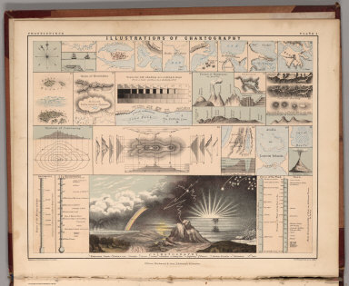
(Frontispiece) Illustrations of Chartography.
List No
0370.003
Author
Johnston, Alexander Keith
Full Title
(Title Page to) Atlas Of Physical Geography, Illustrating, In A Series Of Original Designs, The Elementary Facts Of Geology, Hydrology, Meteorology, And Natural History. By Alex. Keith Johnston, F.R.S.E. F.R.G.S. F.G.S ... Second Edition. William Blackwood And Sons, Edinburgh And London. MDCCCLII.
List No
0370.004
Author
Johnston, Alexander Keith
Full Title
(Text Page) Preface.
List No
0370.005
Author
Johnston, Alexander Keith
Full Title
(Table of Contents) Contents.
List No
0370.006
Author
Johnston, Alexander Keith
Full Title
(Text Page) Description of the Plates.
List No
0370.007
Author
Johnston, Alexander Keith
Full Title
(Text Page) Description of the Plates.
List No
0370.008
Author
Johnston, Alexander Keith
Full Title
(Text Page) Description of the Plates.
List No
0370.009
Author
Johnston, Alexander Keith
Full Title
Chart of the World Showing the Forms and Directions of the Ocean Currents.
List No
0370.010
Author
Johnston, Alexander Keith
Full Title
Comparative Form and Extent of the Inland Seas and Lakes of the Globe .....
List No
0370.011
Note
Shows world water bodies on the same scale.
Author
Johnston, Alexander Keith
Full Title
The River Systems of the World....
List No
0370.012
Author
Johnston, Alexander Keith
Full Title
The Mountains, Table Lakes, Plains & Valleys of Europe ....
List No
0370.013
Author
Johnston, Alexander Keith
Full Title
The Mountains, Table Lands, Plains & Valleys of Asia ....
List No
0370.014
Author
Johnston, Alexander Keith
Full Title
The Mountains, Table Lands, Plains & Valleys of Africa ....
List No
0370.015
Author
Johnston, Alexander Keith
Full Title
The Mountains, Table Lands, Plains & Valleys of N. America ....
List No
0370.016
Author
Johnston, Alexander Keith
Full Title
The Mountains, Table Lands, Plains & Valleys of South America ....
List No
0370.017
Author
Johnston, Alexander Keith
Full Title
The Mountains, Table Lands, Plains & Valleys of the British Isles.
List No
0370.018
Author
Johnston, Alexander Keith
Full Title
The Distribution of Earthquakes & Volcanoes over the Globe.
List No
0370.019
Note
Includes profiles of mountains, extent of Lisbon tsunami, and extent of historical earthquakes.
Author
Johnston, Alexander Keith
Full Title
Climatological Chart, Showing by Lines & Figures the Mean Annual Temperature of the principal places on the Globe.
List No
0370.020
Author
Johnston, Alexander Keith
Full Title
The Distribution of Constant Periodical & Variable Winds over the Globe and the Regions visited by Storms & Hurricanes.
List No
0370.021
Note
Special diagram of the April, 1843, Rodriguez Hurricane (Indian Ocean).
Author
Johnston, Alexander Keith
Full Title
The Distribution of Rain and Snow over the Globe.
List No
0370.022
Author
Johnston, Alexander Keith
Full Title
The Distribution of the Most Important Trees, Shrubs, Grains, & Fruits According to Zones of Climate & Moisture.
List No
0370.023
Note
Includes mountain profile.
Author
Johnston, Alexander Keith
Full Title
The Distribution of Animals Including the Mammalia, Birds, Reptiles & Fishes; According to Zones of Climate.
List No
0370.024
Author
Johnston, Alexander Keith
Full Title
Ethnographic Map of the World Showing the Present Distribution of the Leading Races of Man. (inset) Enlarged Ethnographic Map of Europe.
List No
0370.025
Author
Johnston, Alexander Keith
Full Title
Moral & Statistical Chart, Showing the Distribution of Man According to the Prevailing Forms of Religious Belief & the Proportional Number of Each Creed in the Principal States of the Globe.
List No
0370.026
|