|
REFINE
Browse All : National Atlas of South Dakota
1-37 of 37
Author
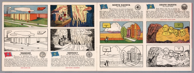
[Fisher, Joseph R., Planters Peanuts (Firm)]
Full Title
Tennessee : The volunteer state -- Kentucky : The blue grass state -- North Dakota : The Sioux state -- South Dakota : The coyote state.
List No
14374.013
Note
Four views, representing Tennessee, Kentucky, North Dakota and South Dakota. Views show examples of the landscape and natural resources. Each view includes an inset map of the state, which marks the location of the capital city with a star. Accompanied by descriptive text, the state flags, seals and flowers: iris, goldenrod, wild prairie rose and pasque flower, respectively. The view of each state appears both in color (on top) and in black and white (bottom), the latter inviting coloration. Together, views are 18 x 52 cm, on two sheets 20 x 54 cm.
Author
Arbuckle Bros.
Full Title
Indian Territory, New Mexico, South Dakota, Texas. Copyright 1889 Arbuckle Bros. N.Y.
List No
0027.005
Note
Sheet with maps of four states in full color. "Indian Territory" is now known as Oklahoma. It is noted that, "Of the 41,000,000 acres in the Territory, nearly 26,000,000 have been surveyed and set apart as reservations for the Indians. These have been gathered from all parts of the country, from Oregon to Florida, in pursuance of the general plan of congregating all the Indians in one territory, to be theirs forever." Each card measures 7.5 x 12.5 cm.
Author
Asher & Adams
Full Title
Asher & Adams' Dakota. Entered according to Act of Congress in the year 1874 by Asher & Adams ... at Washington. (New York, 1874)
List No
0041.034
Note
Hand col. engraved map. Shows townships, etc. Prime meridians: Greenwich and Washington.
Author
[Gray, Frank A., Gray, O.W.]
Full Title
Gray's New Map of Dakota with Part of Manitoba, Etc. by Frank A. Gray. Copyright 1883 by O.W. Gray & Son.
List No
0312.037
Author
U.S. General Land Office
Full Title
Dakota Territory. Department of the Interior, General Land Office, October 2nd 1866. Jo. S. Wilson, Commissioner. The Major & Knapp Eng. Mfg. & Lith. Co. 71 Broadway, N.Y.
List No
1070.008
Note
The territory is largely unsurveyed. Surveying has only been completed in a few townships right along the Missouri River. The map shows the treaty line of July 23, 1851.
Author
U.S. General Land Office
Full Title
Department of the Interior, General Land Office. S.S. Burdett, Commissioner.Territory of Dakota. 1876. Compiled from the official records of the General Land Office and other sources by C. Roeser, Principal Draughtsman G.L.O. Photolith. & Print by Julius Bien 16 & 18 Park Place, N.Y.
List No
11179.008
Note
Color map. Includes references. Relief shown by hachures. Prime meridian is Greenwich.
Author
Rand McNalley & Company
Full Title
Rand McNally road map : South Dakota.
List No
14003.041
Note
Road map of South Dakota, showing interstate and state highways, paved and dirt roads, and ferries, as well as state and national parks. Includes compass rose, time zones, and bar scale with scale statement: One inch equals approximately 18 miles. Features legend indicating population. Copyright by Rand McNally & Company, Chicago, Ill. Lithographed in the U.S.A.
Author
[Bates, Ernest Sutherland, 1879-1939, Schiff, Herman S., Reeves, Norman, Smith, Robert E.]
Full Title
South Dakota, 1889.
List No
14244.089
Note
Pictorial map of South Dakota, showing political boundaries with bordering states and major rivers. Features significant sites (Badlands), as well as natural resources and manufactured items (including silver, flax, hogs and honey). Includes a compass rose and a scroll listing notable places and people - such as Pioneer Spaniards - which are pictured in vignettes below map, in order of listing. Map is 17 x 29 cm, on sheet 23 x 29 cm. Accompanied by historical text on facing page.
Author
Bradstreet Company
Full Title
Dakota. (to accompany) Bradstreet's Pocket Atlas Of The United States. Published Exclusively for Macullar, Parker & Company, Boston, Massachusetts ... New York: The Bradstreet Company, 1885. (on verso) Entered ... 1879, by The Bradstreet Company ... Washington.
List No
2054.054
Note
Full color map. Relief shown by hachures. Prime meridian is Washington, D.C.
Author
Rand McNally and Company
Full Title
(Text Page) Colorado. Dakota.
List No
2094CZ
Note
List of geographical features indexed to map.
Author
Rand McNally and Company
Full Title
Rand, McNally & Co.'s Dakota.
List No
2094.049
Note
Counties outlined in color. Meridians Washington and Greenwich. Railroads highlighted. Relief shown by hachures.
Author
[Lloyd, H.H., Warner & Beers]
Full Title
Atlas of the United States, Map of the Territory of Dakota, and the States of Minnesota, and Nebraska. Warner & Beers, Publishers. From H.H. Lloyd & Co.'s Atlas of the United States.
List No
2585.074
Note
Relief shown in hachures.
Author
Rand McNally and Company
Full Title
Rand, McNally & Co.'s South Dakota.
List No
2844.069
Note
Tables of railroads and chief cities keyed to map.
Author
Rand McNally and Company
Full Title
(Text Page) Rand, McNally Co.'s South Dakota.
List No
2844DM
Note
Tables of railroads and geographical features keyed to map.
Author
Smith, J. Calvin
Full Title
(Minnesota, Wisconsin, North Dakota, South Dakota).
List No
3471.001
Note
Estimated Date. Part of a sixteen piece map combined digitally as a composite in final map of series.
Author
National Map Company
Full Title
South Dakota. (Copyrighted by) National Map Company, Indianapolis. (to accompany) Official Paved Road and Commercial Survey of the United States.
List No
4048.043
Note
Outline color map. Shows administrative divisions, roads, rivers, etc. Relief shown by hachures. Prime meridian is Greenwich.
Author
State Farm Insurance Companies Travel Bureau
Full Title
State Farm Road map: South Dakota. Copyright by Rand McNally & Company, Chicago, Ill. Lithographed in U.S.A. X.3608. (on upper corners) South Dakota.
List No
4246.042
Note
Color map. Shows roads, points of interest, distances, time zone boundaries, populations, etc. U.S. interstate and principal state highways shown in red. Relief shown by hachures.
Author
Clason Map Company
Full Title
Clason's Road Map of South Dakota. Showing paved roads, All weather roads and other throughfares. (U.S. Highways shown in red.) Published by the Clason Map Co., Denver. Copyrighted Clason Map. All rights reserved. Map No. R-271A.
List No
4423.035
Note
Color map. Includes road legend, and Index of cities and towns giving 1930 Census populations and Key to map.
Author
Rand McNally and Company
Full Title
Rand, McNally & Co.'s Dakota.
List No
4520.043
Note
States in outline color by county. Relief shown by hachures. Shows named railroads. Prime meridians: Greenwich and Washington.
Author
Cram, George Franklin
Full Title
Cram's Rail Road & Township Map of Dakota.
List No
4533.027
Author
Asher & Adams
Full Title
Asher & Adams' Dakota. Entered according to Act of Congress 1875 by Asher & Adams in the Office of the Librarian of Congress at Washington.
List No
4977.066
Note
Washington Meridian. Hand tinted full color. Shows railroads, settlements, counties, waterways, and lakes. Topography shown by hachures. Engraved.
Author
Rand McNally and Company
Full Title
(Text Page) Industrial Statistics of the United States. South Dakota. Tennessee. Texas.
List No
5028AH
Note
Industrial statistics by state and county including county seat, area, and statistics on population, agriculture and manufacturing. Includes descriptions of mines, quarries, and wells.
Author
Rand McNally and Company
Full Title
(Text Page) South Dakota - Counties, Creeks, Lakes, Mountains, Rivers, and Towns.
List No
5028DB
Note
Geographical features keyed to map; populations of towns. Shows electric lines.
Author
Rand McNally and Company
Full Title
Commercial Atlas of America. Rand McNally Standard Map of South Dakota.
List No
5028.101
Note
Shows railroads and distances. Includes tables of principal cities and railroads, keyed to map.
Author
Rand McNally and Company
Full Title
(Text Page) South Dakota - Counties, Creeks, Lakes, Mountains, Rivers, and Towns.
List No
5028DC
Note
Geographical features keyed to map; populations of towns. Shows electric lines.
Author
Rand McNally and Company
Full Title
Commercial Atlas of America. Rand McNally Black and White Mileage Map, South Dakota.
List No
5028.102
Note
Shows railroads and distances.
Author
Mitchell, Samuel Augustus Jr.
Full Title
County Map of Colorado, Wyoming, Dakota, Montana.
List No
5041.041
Note
Relief shown in hachures. Prime meridians are Washington D.C. and Greenwich.
Author
Cram, George Franklin
Full Title
Cram's Rail Road & Township Map of Dakota. Published by Geo. F. Cram. Proprietor of the Western Map Depot. 66, Lake St. Chicago Ills. 1875.
List No
5370.020
Note
Map in full color by county. The railroad lines are clearly marked. (Note: The map has been rotated 90 degrees clockwise for readability.)
Author
Colton, G.W.
Full Title
Minnesota (and Dakotah). No. 49. Published by J.H. Colton & Co., No 172 William St., New York. Entered according to the Act of Congress in the year 1855 by J.H. Colton & Co. in the Clerk's Office of the District Court of the United States for the Southern District of New York.
List No
5479.095
Note
Meridians Washington and Greenwich. Counties tinted in color. Includes note on the Indian "Fighting Grounds" of the Prairies.
Author
Colton, G.W.
Full Title
Nebraska and Kansas. No. 50. Published by J.H. Colton & Co., No 172 William St., New York. Entered according to the Act of Congress in the year 1855 by J.H. Colton & Co. in the Clerk's Office of the District Court of the United States for the Southern District of New York.
List No
5479.097
Note
Meridians Washington and Greenwich. Tinted in color.
Author
Rand McNally and Company
Full Title
Rand McNally junior auto road map South Dakota. Copyright by Rand McNally & Company, Chicago, Ill. (1927)
List No
5755.023
Note
Color map. Relief shown by hachures. Shows settlements, classified roads with distances, etc. "I-30."
Author
Marbut, Curtis F.
Full Title
Soil Map of the United States by Curtis F. Marbut and Associates in the Soil Survery, U.S. Department of Agriculture, F.J. Marschner, Cartographer and Associate in Compilation. 1931. Soils, Plate 5, Section 3. Lith. A. Hoen & Co., Inc. Atlas of American Agriculture.
List No
5797.084
Note
Includes legend of 12 map sections. Includes soils legend for this section and landscape photographs.
Author
Shell Oil Company
Full Title
Shell Map of North Dakota, South Dakota (cover title). Shell Highway Map of South Dakota. 9-W 1949-1.
List No
5840.065
Author
[State Farm Insurance Companies Travel Bureau, Rand McNally and Company]
Full Title
Rand McNally Road map, South Dakota. Copyright by Rand McNally & Company, Chicago, Ill. Lithographed in the U.S.A. (to accompany) State Farm Road Atlas: United States, Canada, Mexico,Central and South America. Copyright 1940 by Rand McNally & Company, Chicago, Ill.
List No
5969.049
Note
Color map. U.S. Interstate highways shown in red. Shows roads, capitals, population of cities and towns, Indian reservations, etc. Relief shown by hachures and spot heights.
Author
[Rand McNally and Company, State Farm Insurance Companies Travel Bureau]
Full Title
Rand McNally Road map: South Dakota. Copyright by Rand McNally & Company, Chicago, Ill. Lithorgaphed in the U.S.A. U.3608. (to accompany) State Farm road atlas : United States, Canada, Mexico.
List No
6825.046
Note
Color map. U.S. interstate highways shown in red. Shows time zone boundaries, roads, ferries, highways, rivers and streams. Includes population of cities and towns. Relief shown by hachures.
Author
[Taylor, Frank J., White, Ruth Taylor]
Full Title
South Dakota.
List No
7823.096
Author
[Hader, Berta Hoerner (1890-1976), Hader, Elmer Stanley (1889-1973]
Full Title
North Dakota. South Dakota.
List No
8763.048
1-37 of 37
|