|
Author
[Fisher, Joseph R., Planters Peanuts (Firm)]
Full Title
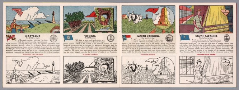
Maryland : The old line state -- Virginia : The old dominion -- North Carolina : The tar heel state -- South Carolina : The palmetto state.
List No
14374.006
Note
Four views, representing Maryland, Virginia, North Carolina and South Carolina. Views show examples of the landscape and natural resources. Each view includes an inset map of the state, which marks the location of the capital city with a star. Accompanied by descriptive text, the state flags, seals and flowers: black-eyed Susan, dogwood, dogwood and yellow jessamine, respectively. The view of each state appears both in color (on top) and in black and white (bottom), the latter inviting coloration. Together, views are 18 x 52 cm, on two sheets 20 x 54 cm.
Author
Popple, Henry
Full Title
A Map of the British Empire in America with the French and Spanish Settlements adjacent thereto. by Henry Popple. (Sheet 12).
List No
2874.014
Note
Far right extent of map includes five inset maps: New York and Perth Amboy Harbours, The Town and Harbour of Charles Town in South Carolina, The Bermuda or Summer Islands, Harbour of St. Augustine, and The Harbour of Providence. Soundings often included. Uncolored.
Author
Arbuckle Bros.
Full Title
South Carolina, Wisconsin, Maine, Michigan. Copyright 1889 Arbuckle Bros. N.Y.
List No
0027.001
Note
Sheet with maps of four states in full color. The notes for Maine mention that the population included "8 Chinese." It is also noted that in Michigan although the climate in the winter is "cold and rigorous," the death rate is low. Each card measures 7.5 x 12.5 cm.
Author
Asher & Adams
Full Title
Asher & Adams' North Carolina and South Carolina. Entered according to Act of Congress in the year 1874 by Asher & Adams ... at Washington. (New York, 1874)
List No
0041.009
Note
Hand col. engraved map. Relief shown by hachures. Shows distances along railroads, etc. Includes inset: Western portion of North Carolina. Prime meridians: Greenwich and Washington.
Author
[Bartholomew, John, Black, Adam & Charles]
Full Title
North & South Carolina. Published by A. & C. Black. Edinburgh. Printed in Colours by Schenck & Macfariane. Edinburgh. Drawn & Engraved by J. Bartholomew, Edinburgh.
List No
0073.011
Note
States outlined in color. Land tinted.
Author
Bradford, Thomas G.
Full Title
South Carolina. Entered ... 1838, by T.G. Bradford ... Massachusetts. Engraved by G.W. Boynton.
List No
0089.029
Note
In full color.
Full Title
Carte geographique, statistique et historique de la Caroline du Sud. Caroline Meridionale. Grave par Le Gagneur, Rue de Marche-Neuf, No. 8. Fonderie et Imprimerie de J. Carez. (1825)
List No
0102.024
Note
Hand colored engraved map. Relief shown by hachures. Text and tables at sides and bottom. Prime meridians: Washington and Paris.
Author
Burr, David H., 1803-1875
Full Title
Map of North And South Carolina Exhibiting the Post Offices, Post Roads, Canals, Rail Roads, &c. By David H. Burr. (Late Topographer to the Post Office.) Geographer to the House of Representatives of the U.S. John Arrowsmith. Entered ... July 10th, 1839, by David H. Burr ... District of Columbia.
List No
0104.006
Note
In full color by county. Postal routes by coach, stage, sulkey, cross, rail roads and canals shown. In 8 sections mounted on linen. Label on back states "No. 6. North & South Carolina."
Author
[Carey, H. C., Lea, I.]
Full Title
Geographical, Historical, And Statistical Map Of South Carolina. South Carolina. No. 24. Reduced by J. Drayton from the State Map by J. Wilson. Engraved by Samuel Hufty.
List No
0122.019
Note
In full color by county surrounded by text.
Author
Finley, Anthony
Full Title
Map Of North and South Carolina And Georgia, Constructed from the Latest Authorities. 1825. Copyright secured. J.H. Young Sculp. Published by A. Finley Philada. 1824.
List No
0278.008
Note
In full color by county. Topographical table includes population by state from the 1820 census for "White, Free Black & Slave Population".
Author
Finley, Anthony
Full Title
Map of North and South Carolina and Georgia, Constructed from the Latest Authorities, 1827.
List No
0279.012
Author
Finley, Anthony
Full Title
Map of North and South Carolina, and Georgia, Constructed from the Latest Authorities. 1827. Copyright secured. Published by A. Finley, Philada. 1827. J.H. Young Sculp.
List No
0280.008
Note
Relief shown by hachures. Prime meridian Washington. Statistical table for state.
Author
[Gray, Frank A., Gray, O.W.]
Full Title
Gray's New Map of North Carolina and South Carolina by Frank A. Gray. Entered ... 1881 by O.W. Gray & Son. (insert) Charleston Harbor and its Approaches.
List No
0312.024
Author
[Jefferys, Thomas, Mouzon, Henry]
Full Title
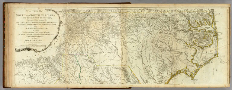
An Accurate Map Of North And South Carolina With Their Indian Frontiers, Shewing in a distinct manner all the Mountains, Rivers, Swamps, Marshes, Bays, Creeks, Harbours, Sandbanks and Soundings on the Coasts; with The Roads and Indian Paths; as well as The Boundary or Provincial Lines, The Several Townships and other divisions of the Land In Both The Provinces; the whole From Actual Surveys By Henry Mouzon And Others. London. Printed for Robt. Sayer and J. Bennett ... May 30th 1775. (Northern Section)
List No
0346.026
Note
In outline color by state. In two sections with this being the northernmost. Large title cartouche at upper left.
Author
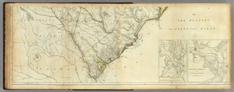
[Jefferys, Thomas, Mouzon, Henry]
Full Title
An Accurate Map Of North And South Carolina With Their Indian Frontiers, Shewing in a distinct manner all the Mountains, Rivers, Swamps, Marshes, Bays, Creeks, Harbours, Sandbanks and Soundings on the Coasts; with The Roads and Indian Paths; as well as The Boundary or Provincial Lines, The Several Townships and other divisions of the Land In Both The Provinces; the whole From Actual Surveys By Henry Mouzon And Others. (with) two inset maps: The Harbour of Port Royal and The Bar and Harbour of Charlestown. London. Printed for Robt. Sayer and J. Bennett ... May 30th 1775. (Southern Section)
List No
0346.027
Note
In outline color by state. In two sections with this being the southern. Title cartouche on northern section.
Author
[Jefferys, Thomas, Mouzon, Henry]
Full Title
(Composite of) An Accurate Map Of North And South Carolina With Their Indian Frontiers, Shewing in a distinct manner all the Mountains, Rivers, Swamps, Marshes, Bays, Creeks, Harbours, Sandbanks and Soundings on the Coasts; with The Roads and Indian Paths; as well as The Boundary or Provincial Lines, The Several Townships and other divisions of the Land In Both The Provinces; the whole From Actual Surveys By Henry Mouzon And Others. London. Printed for Robt. Sayer and J. Bennett ... May 30th 1775.
List No
0346.028
Note
In outline color by state.
Author
[Reid, John, Winterbotham, W.]
Full Title
The State of South Carolina from the best Authorities. 1796. Tanner, Sc. Published by John Reid New York.
List No
0845.017
Note
Uncolored.
Author
Rand McNalley & Company
Full Title
Rand McNally road map : North Carolina -- South Carolina.
List No
14003.035
Note
Road map of North Carolina and South Carolina, showing interstate and state highways, paved and dirt roads, as well as drainage and ports, and state and national parks. Includes compass rose, time zones, and bar scale with scale statement: One inch equals approximately 22 miles. Features legend indicating population. Copyright by Rand McNally & Company, Chicago, Ill. Lithographed in the U.S.A.
Author
[Bates, Ernest Sutherland, 1879-1939, Schiff, Herman S., Reeves, Norman, Smith, Robert E.]
Full Title
South Carolina, 1663, 1729.
List No
14244.023
Note
Pictorial map of South Carolina, showing political boundaries with bordering states and coastline. Features natural resources and manufactured items (including apples, yams, lumber and textiles). Includes a compass rose and a scroll listing notable places and events - such as Captain Teach, The Pirate 1770 - which are pictured in vignettes to the right of map, in order of listing. Map is 22 x 24 cm, on sheet 23 x 29 cm. Accompanied by historical text on facing page.
Author
Bradstreet Company
Full Title
South Carolina. (to accompany) Bradstreet's Pocket Atlas Of The United States. Published Exclusively for Macullar, Parker & Company, Boston, Massachusetts ... New York: The Bradstreet Company, 1885. (on verso) Entered ... 1879, by The Bradstreet Company ... Washington.
List No
2054.029
Note
Full color map. Prime meridian is Greenwich.
Author
Rand McNally and Company
Full Title
(Text Page) South Carolina.
List No
2094AU
Note
List of geographical features indexed to map.
Author
Rand McNally and Company
Full Title
Rand, McNally & Co.'s New Map of South Carolina.
List No
2094.027
Note
Counties outlined in color. Meridians Washington and Greenwich. Railroads highlighted. Relief shown by hachures.
Author
Rand McNally and Company
Full Title
(Text Page) South Carolina.
List No
2094AV
Note
List of geographical features indexed to map.
Author
[Breese, Samuel, 1802-1873, Morse, Sidney E. (Sidney Edwards), 1794-1871]
Full Title
South Carolina. Entered ... 1843 by Sidney E. Morse and Samuel Breese ... New York. (New York: Published by Harper & Brothers, 1845)
List No
2301.025
Note
Col. wax engraved map. Relief shown by hachures. Prime meridians: Greenwich and Washington.
Author
Henshaw, Frances A.
Full Title
South Carolina.
List No
2501.014
Note
State in outline color.
Author
Henshaw, Frances A.
Full Title
(Description of) South Carolina.
List No
2501P
Note
The right hand side of the text has been cut off during binding. Frances notes that the Carolinians are affable in their manners and attentive to strangers.
Author
[Carey, Mathew, Lewis, Samuel]
Full Title
The State of South Carolina: from the best Authorities, By Samuel Lewis. 1795. W. Barker sculp. Engraved for Carey's American Edition of Guthrie's Geography improved.
List No
2542.015
Note
Uncolored.
Author
Lange, Henry, 1821-1893.
Full Title
Alabama, Georgia, Sud Carolina und Florida. H. Lange's Atlas v. Nord Amerika Blatt V. Braunschweig: Verlag v. George Westermann. Lith. Anst. von L. Kraatz in Berlin.
List No
2743.005
Note
Engraved map. Borders hand col. Shows roads, railroads, swamps, etc. Relief shown by hachures.
Author
Tanner, Henry S.
Full Title
North & South Carolina. (engraved by) J. Knight. Sc. (to accompany) A New Pocket Atlas of the United States With The Roads and Distances, Designed For the Use of Travelers. By H.S. Tanner. Philadelphia: Published by the Author. 1828. (on verso) ...on the seventeenth day of November ... 1828, Henry S. Tanner ... hath deposited ... a book ... Pennsylvania.
List No
2782.011
Note
Outline colored map. Prime meridian is Washington, D.C. Rare. Same maps used in Darby's View of U.S. Although this appears in Tanner's catalogues for several years after 1828, it must not have sold well, as few copies have survived. Bound with half leather and paper covered boards. "Pocket Atlas" embossed on spine.
Author
Rand McNally and Company
Full Title
(Text Page) Rand, McNally Co.'s North Carolina. Rand, McNally Co.'s South Carolina.
List No
2844AZ
Note
Tables of railroads and geographical features keyed to map.
Author
Rand McNally and Company
Full Title
Rand, McNally & Co.'s South Carolina.
List No
2844.033
Note
Relief shown by hachures. Railroads and chief cities listed and keyed to map.
Author
Rand McNally and Company
Full Title
(Text Page) Rand, McNally Co.'s South Carolina.
List No
2844BA
Note
Tables of geographical features keyed to map.
Author
Rand McNally and Company
Full Title
(Text Page) Rand, McNally Co.'s South Carolina. Rand, McNally Co.'s Georgia.
List No
2844BB
Note
Tables of railroads and geographical features keyed to map.
Author
Smith, J. Calvin
Full Title
(Virginia, North Carolina, South Carolina).
List No
3471.011
Note
Estimated Date. Part of a sixteen piece map combined digitally as a composite in final map of series.
Author
[Johnston, Alexander Keith, 1804-1871, Rogers, Henry Darwin]
Full Title
The City of Charleston, (South Carolina,) With its Harbour and Forts. London: Published by Edward Stanford, 6, Charing Cross, S.W. Feb 1st 1861.
List No
3825.001
Note
Map of Charleston mounted on the inside cover of the atlas in printed partial color. The forts are colored in red.
Author
[Johnston, Alexander Keith, 1804-1871, Rogers, Henry Darwin]
Full Title
States Of South Carolina, Georgia, Alabama, And Florida. By Prof. H.D. Rogers & A. Keith Johnston, F.R.S.E. Entered in Sta. Hall. London ... & according to an act of Congress ... 1857, by H.D. Rogers ... Massachusetts. London, John Murray, Albemarle Street, Edinburgh, W. & A.K. Johnston. Engraved by W. & A.K. Johnston, Edinburgh.
List No
3825.016
Note
States and counties shown in outline printed color. Bahamas shown off the Florida coast.
Author
Mitchell, Samuel Augustus
Full Title
Map Of North and South Carolina And Georgia, Constructed from the Latest Authorities. Published by S. Augustus Mitchell Philadelphia. 1831. J.H. Young Sc.
List No
3884.008
Note
Full color by county.
Author
National Map Company
Full Title
North Carolina. (Copyrighted by) National Map Company, Indianapolis. (Scale 1:2,200,000). South Carolina. (Copyrighted by) National Map Company, Indianapolis. (Scale 1:1,400,000), (to accompany) Official Paved Road and Commercial Survey of the United States.
List No
4048.031
Note
2 outline color maps on 2 pages. Shows administrative divisions, roads, rivers, etc. Relief shown by hachures. Prime meridian is Greenwich.
Author
[Morse, Sidney E. (Sidney Edwards), 1794-1871, Breese, S.]
Full Title
South Carolina. (to accompany) Supplement To The New-York Observer. The Cerographic Atlas Of The United States. No.3. 1845. Entered ... 1843, by Sidney E. Morse and Samuel Breese ... New-York.
List No
4180.028
Note
Uncolored map. Shows state capital, county, towns, roads, railroads, rivers, canals, etc. Relief shown by hachures. Prime meridians are Greenwich and Washington. Includes explanation.
Author
State Farm Insurance Companies Travel Bureau
Full Title
State Farm Road map: North Carolina, South Carolina. Copyright by Rand McNally & Company, Chicago, Ill. Lithographed in U.S.A. Z.3618. (on upper corners) N. Car., S. Car.
List No
4246.036
Note
Color map. Shows roads, points of interest, distances, time zone boundaries, populations, etc. U.S. interstate and principal state highways shown in red.
Author
Hillebrands, A.J.
Full Title
Atlas de Vereenigde Staten No. 6. North Carolina, South Carolina en Georgia.
List No
4323.008
Note
A scarce small atlas of ten maps published in Holland, but authored by a school teacher from the Dutch Colony in Holland, Michigan. It was most likely sold to Dutch Americans and those in Holland planning to emigrate or who had relatives in America. The date is estimated by Phillips and Koeman. Koeman lists an earlier edition of 1849, with five maps. There is a double page of text at the end of the maps, with lists of distances by steamboat and railroad. The copy listed in Phillips has a cover title, not present here. Maps are hand painted with outline color.
Author
Clason Map Company
Full Title
Clason's Road Map of North Carolina and South Carolina. Showing paved roads, All weather roads and other throughfares. (U.S. Highways shown in red.) Published by the Clason Map Co., Denver. Copyrighted Clason Map. All rights reserved. Map No. R-277A.
List No
4423.017
Note
Color map. Includes road legend, and Index of cities and towns giving 1930 Census populations and Key to map.
Author
Rand McNally and Company
Full Title
Rand, McNally & Co.'s North and South Carolina.
List No
4520.033
Note
In outline color by county. Shows named railroads. Relief shown by hachures. Prime meridians: Greenwich and Washington.
Author
Cram, George Franklin
Full Title
Cram's Rail Road & County Map of North and South Carolina.
List No
4533.021
Author
[Morse, Sidney E. (Sidney Edwards), 1794-1871, Breese, Samuel]
Full Title
South Carolina. Entered ... 1845 by Sidney E. Morse and Samuel Breese ... New York. (New York: Published by Harper & Brothers, 1845). (to accompany) Morse's Cerographic Maps. No. IV.
List No
4861.034
Note
Color wax engraved map. Shows capital, towns, road, railroads, rivers, canals, etc. Includes explanation. Relief shown by hachures. Prime meridians are Greenwich and Washington.
Author
Carey, Mathew
Full Title
South Carolina. Engraved by Doolittle Newhaven.
List No
4865.018
Note
Uncolored.
Full Title
North Carolina, South Carolina and Georgia. (with) Charleston and vicinity. N. & S.S. Jocelyn Sc. (New-Haven: N. & S.S. Jocelyn. 1823)
List No
4869.007
Note
Engraved map with inset and facing index page. Outline hand color. Relief shown by hachures. Prime meridians: Washington and Greenwich.
Author
[Hinton, Isaac Taylor, 1799-1847, Simpkin & Marshall]
Full Title
Map of the states of North & South Carolina. (with) Plan of Charleston. London, published June 1 by I.T. Hinton & Simpkin & Marshall. Engraved & printed by Fenner Sears & Co. (1832)
List No
4966.009
Note
Hand col. engraved map. Relief shown by hachures. Prime meridians: Washington and Greenwich. "53."
Author
Asher & Adams
Full Title
Asher & Adams' North Carolina and South Carolina. Entered according to Act of Congress 1874 by Asher & Adams in the Office of the Librarian of Congress at Washington.
List No
4977.020
Note
Washington Meridian. Hand tinted full color. Relief shown in hachures. Shows railroads, settlements, counties, waterways, and lakes. Engraved.
Author
Rand McNally and Company
Full Title
(Text Page) Industrial Statistics of the United States. Oregon. Pennsylvania. Rhode Island. South Carolina. South Dakota.
List No
5028AG
Note
Industrial statistics by state and county including county seat, area, and statistics on population, agriculture and manufacturing. Includes descriptions of mines, quarries, and wells.
|