|
Author
Robert Sayer and John Bennett (Firm)
Full Title
A General Map of the Northern British Colonies in America, which comprehends the Province of Quebec, the Government of Newfoundland, Nova-Scotia, New-England and New-York. from the Maps Published by the Admiralty and Board of Trade, Regulated by the Astronomic and Trigonometric Observations of Major Holland, and Corrected from Governor Pownall's Late Map 1776. London: Printed for Robt. Sayer & Jno. Bennett ... 14th August 1776.
List No
0875.003
Note
In outline color. Above the map reads, "The Seat of War, in the Northern Colonies containing the Province of Quebec, Newfoundland, Nova-Scotia, New-England, New-York, New-Jersey, Pennsylvania, &ca."
Author
Popple, Henry
Full Title
A Map of the British Empire in America with the French and Spanish Settlements adjacent thereto. by Henry Popple. (Sheet 2).
List No
2874.004
Note
Uncolored map of lower Quebec stretching from Hudson's Bay to "Lake Mistasin."
Author
Popple, Henry
Full Title
A Map of the British Empire in America with the French and Spanish Settlements adjacent thereto. by Henry Popple. (Sheet 3).
List No
2874.005
Note
Sheet three without color and stretching from the mouth of the St. Lawrence to Newfoundland.
Author
Popple, Henry
Full Title
A Map of the British Empire in America with the French and Spanish Settlements adjacent thereto. by Henry Popple. (Sheet 4).
List No
2874.006
Note
Sheet four includes two city views - Quebec and New York. Both views have labeled points, which are explained on the legends to the right of each map. The "Grand Fishing Bank" is also shown and includes soundings. Uncolored.
Author
Asher & Adams
Full Title
Asher & Adams' part of Quebec. Entered according to Act of Congress in the year 1874 by Asher & Adams ... at Washington. (New York, 1874)
List No
0041.003
Note
Hand col. engraved map. Relief shown by hachures. Shows distances along railroads, etc. Prime meridians: Greenwich and Washington.
Author
Asher & Adams
Full Title
Asher & Adams' Maine and New Brunswick with portions of Quebec & Nova Scotia. Entered according to Act of Congress in the year 1874 by Asher & Adams ... at Washington. (New York, 1874)
List No
0041.004
Note
Hand col. engraved map. Relief shown by hachures and spot heights. Includes inset map. Shows distances along railroads, etc. Prime meridians: Greenwich and Washington.
Author
Gray, O.W.
Full Title
Provinces of Ontario and Quebec Dominion of Canada. Eastern Portion of the Province of Quebec.
List No
0312.057
Author
Jefferys, Thomas
Full Title
A New Map Of The Province of Quebec, according to The Royal Proclamation, of the 7th of October 1763. from The French Surveys Connected with those made after the War. By Captain Carver, and Other Officers, in His Majesty's Service. (with) four inset maps: A Particular Survey Of The Isles of Montreal; Plan of Montreal, or Villemarie; The City of Quebec; Course of the River St. Laurence, from la Valterie to Quebec on a Larger Scale. London. Printed for Robt. Sayer and John Bennett ... 16th February 1776.
List No
0346.021
Note
In outline color with the waterways in a blue wash. The cities are shown with labeled points of reference.
Author
Melish, John
Full Title
Plan of Montreal, with a Map of the Islands & adjoining Country.
List No
0495.007
Note
Two uncolored maps on the page.
Author
Rand McNalley & Company
Full Title
Rand McNally road map : Quebec.
List No
14003.048
Note
Road map of Quebec, showing interstate and state highways, paved and dirt roads, ferries and boatlines, as well as state parks. Includes compass rose, time zones, and bar scale with scale statement: One inch equals approximately 22 miles. Features legend indicating population. With inset: Northeastern Quebec. Copyright by Rand McNally & Company, Chicago, Ill. Lithographed in the U.S.A.
Author
[Master, Oliver, Elias, Arthur Edward, Funk & Wagnalls Company.]
Full Title
Animated Map of Quebec. The Artist Suggests Good Sport.
List No
1643.011
Author
[White, James, Canada. Department of Interior]
Full Title
Department of Interior : Atlas of Canada, No.10, Telegraphs : Quebec and Maritime Provinces. (to accompany) Department of the Interior, Canada ... 1906. (Untitled inset of) Strait of Belle Isle.
List No
1645.023
Note
Full color map. Shows land and underwater telegraph cables, railroads, rivers, etc.
Author
[White, James, Canada. Department of Interior]
Full Title
Department of Interior : Atlas of Canada, No.11, Telegraphs : Ontario and Quebec. (to accompany) Department of the Interior, Canada ... 1906. (Untitled inset of) Rainy River.
List No
1645.024
Note
Full color map. Shows land and underwater telegraph cables, railroads, rivers, etc.
Author
[White, James, Canada. Department of Interior]
Full Title
Department of Interior : Atlas of Canada, No.14, Telephone : Maritime Provinces and Quebec. (to accompany) Department of the Interior, Canada ... 1906.
List No
1645.027
Note
Color map. Shows telephone cables, railroads, rivers, etc.
Author
[White, James, Canada. Department of Interior]
Full Title
Department of Interior : Atlas of Canada, No.15, Telephone : Ontario and Quebec. (to accompany) Department of the Interior, Canada ... 1906. (inset) Continuation of map.
List No
1645.028
Note
Color map. Shows telephone cables, railroads, rivers, etc.
Author
[White, James, Canada. Department of Interior]
Full Title
Department of Interior : Atlas of Canada, No.17, Railways: Quebec and Maritime Provinces. (to accompany) Department of the Interior, Canada ... 1906.
List No
1645.030
Note
Full color map. With list of railways, mileage, etc. and color coded legend.
Author
[White, James, Canada. Department of Interior]
Full Title
Department of Interior : Atlas of Canada, No.18, Railways: Ontario and Quebec. (to accompany) Department of the Interior, Canada ... 1906. (inset) Continuation of map.
List No
1645.031
Note
Full color map. With list of railways, mileage, etc. and color coded legend.
Author
[White, James, Canada. Department of Interior]
Full Title
Department of Interior : Atlas of Canada, No. 27 : Density of population, 1901; Maritime Provinces and Quebec. (to accompany) Department of the Interior, Canada ... 1906. (inset) Cape Breton Island.
List No
1645.041
Note
Color map. Cities and towns of 5000 inhabitants or more are shown as black dots. The size of the circle is proportionate to the population. Color coded legend uses eight classes, seven of which are shades of brown, more densely populated portions are shown in the darker tints. Numbers make it clear which class is being shown in any one township.
Author
[White, James, Canada. Department of Interior]
Full Title
Department of Interior : Atlas of Canada, No. 27 A : Density of population, 1901; Ontario and Quebec. (to accompany) Department of the Interior, Canada ... 1906. (insets) Port Arthur; Fort William. (and) Sault Ste. Marie.
List No
1645.042
Note
Color map. Cities and towns of 5000 inhabitants or more are shown as black dots. The size of the circle is proportionate to the population. Color coded legend uses eight classes, seven of which are shades of brown, more densely populated portions are shown in the darker tints. Numbers make it clear which class is being shown in any one township.
Author
[White, James, Canada. Department of Interior]
Full Title
Department of Interior : Atlas of Canada, No. 29 A : Origins of the people, 1901 ; Maritime Provinces and Quebec. (to accompany) Department of the Interior, Canada ... 1906. (inset) Cape Breton Island.
List No
1645.046
Note
Color map. Color coded legend shows varying number of ethnic groups mainly: English, Irish, Scottish, French, German, and Negroes. Includes note. Cities and towns of 5000 inhabitants or more are shown as black dots. The size of the circle is proportionate to the population. Shows major railway systems.
Author
[White, James, Canada. Department of Interior]
Full Title
Department of Interior : Atlas of Canada, No. 29 B : Origins of the people, 1901 ; Ontario and Quebec. (to accompany) Department of the Interior, Canada ... 1906. (insets) Port Arthur; Fort William. (and) Sault Ste. Marie.
List No
1645.047
Note
Color map. Color coded legend shows varying number of ethnic groups mainly: English, Irish, Scottish, French, German, and Russians. Includes note. Cities and towns of 5000 inhabitants or more are shown as black dots. The size of the circle is proportionate to the population. Shows major railway systems.
Author
[White, James, Canada. Department of Interior]
Full Title
Quebec. (on upper margins) Atlas of Canada, Plate No, 36. (to accompany) Department of the Interior, Canada ... 1906. (inset map) St. John.
List No
1645.056
Note
Color map. Shows Shows administrative boundaries, wards, tracts, block numbers, and railway system. Includes legend and reference to the wards. Relief shown by hachures. Depth shown in soundings.
Author
[Canada. Department of Interior, Chalifour, J.E.]
Full Title
Origin of the population 1911: showing predominating people: Maritime Provinces and Quebec. (on upper right margin) Atlas of Canada. (inset) Cape Breton Island. (to accompany) Department of the Interior Canada. Atlas Of Canada, 1915.
List No
1646.021
Note
Color map. Includes color coded legend. Shows major cities, rivers, railroads, etc.
Author
[Canada. Department of Interior, Chalifour, J.E.]
Full Title
Origin of the population 1911: showing predominating people : Ontario and Quebec. (on upper right margin) Atlas of Canada. (insets) Continuation of map. (to accompany) Department of the Interior Canada. Atlas Of Canada, 1915.
List No
1646.022
Note
Color map. Includes color coded legend. Shows major cities, rivers, railroads, etc.
Author
[Canada. Department of Interior, Chalifour, J.E.]
Full Title
Density of population 1911: Maritime Provinces and Quebec. (on upper right margin) Atlas of Canada. (inset) Cape Breton Island. (to accompany) Department of the Interior Canada. Atlas Of Canada, 1915.
List No
1646.025
Note
Color map. Includes color coded legend. Shows major cities, rivers, railroads, etc. Note: "Cities and towns over 5,000 inhabitants in solid black circles proportionate to population."
Author
[Canada. Department of Interior, Chalifour, J.E.]
Full Title
Density of population 1911: Ontario and Quebec. (on upper right margin) Atlas of Canada. (insets) Continuation of map. (to accompany) Department of the Interior Canada. Atlas Of Canada, 1915.
List No
1646.026
Note
Color map. Includes color coded legend. Shows major cities, rivers, railroads, etc. Note: "Cities and towns over 5,000 inhabitants in solid black circles proportionate to population."
Author
[Canada. Department of Interior, Chalifour, J.E.]
Full Title
Quebec and Maritime Provinces. (on upper right margin) Telegraphs. Atlas of Canada. (insets) Continuation of map. (to accompany) Department of the Interior Canada. Atlas Of Canada, 1915.
List No
1646.029
Note
Color map. Shows major cities, rivers, railroads, land and underwater cables, and list of the wireless stations.
Author
[Canada. Department of Interior, Chalifour, J.E.]
Full Title
Ontario and Quebec. (on upper right margin) Telegraphs. Atlas of Canada. (insets) Continuation of map. (to accompany) Department of the Interior Canada. Atlas Of Canada, 1915.
List No
1646.030
Note
Color map. Shows major cities, rivers, railroads, land and underwater cables, and list of the wireless stations.
Author
[Canada. Department of Interior, Chalifour, J.E.]
Full Title
Quebec and Maritime Provinces railway territories. (on upper right margin) Atlas of Canada. (to accompany) Department of the Interior Canada. Atlas Of Canada, 1915.
List No
1646.034
Note
Color map. Shows major cities, rivers, etc. Includes table of routes and names of railroad companies. Includes color coded legend indicates existing and proposed lines in Quebec and Maritime Provinces, Pacific railways and Grand Trunk Railway System.
Author
[Canada. Department of Interior, Chalifour, J.E.]
Full Title
Ontario and Quebec railway territories. (on upper right margin) Railways. Atlas of Canada. (to accompany) Department of the Interior Canada. Atlas Of Canada, 1915. (inset) Continuation of map.
List No
1646.035
Note
Color map. Shows major cities, rivers, etc. Includes table of routes and names of railroad companies. Includes color coded legend indicates existing and proposed lines in Ontario and Quebec, Pacific railways and Grand Trunk Railway System.
Author
[Canada. Department of Interior, Chalifour, J.E.]
Full Title
Population: Province of Quebec; Province of Nova Scotia; Province of New Brunswick; Province of Prince Edward Island. (on upper margin). Atlas of Canada. (to accompany) Department of the Interior Canada. Atlas Of Canada, 1915.
List No
1646.070
Note
Statistical charts. Shows distribution of population in provinces and territories.
Author
[Canada. Department of Interior, Chalifour, J.E.]
Full Title
Population, 1911: Cities and towns with population of upwards of 7,000. (on upper margin). Atlas of Canada. (to accompany) Department of the Interior Canada. Atlas Of Canada, 1915.
List No
1646.071
Note
Statistical charts. Shows population of over 7,000 in cities and towns, 1665-1911.
Author
[Canada. Department of Interior, Chalifour, J.E.]
Full Title
Population, 1911: Cities and towns with population of upwards of 7,000. (on upper margin). Atlas of Canada. (to accompany) Department of the Interior Canada. Atlas Of Canada, 1915.
List No
1646.072
Note
Statistical charts. Shows population of over 7,000 in cities and towns, 1665-1911.
Author
Bradstreet Company
Full Title
Quebec. (to accompany) Bradstreet's Pocket Atlas Of The United States. Published Exclusively for Macullar, Parker & Company, Boston, Massachusetts ... New York: The Bradstreet Company, 1885. (on verso) Entered ... 1879, by The Bradstreet Company ... Washington.
List No
2054.067
Note
Full color map. Relief shown by hachures. Prime meridian is Greenwich.
Author
Rand McNally and Company
Full Title
Rand, McNally & Co.'s Quebec.
List No
2094.013
Note
Counties outlined in color. Meridians Washington and Greenwich. Railroads highlighted.
Author
[Breese, Samuel, 1802-1873, Morse, Sidney E. (Sidney Edwards), 1794-1871]
Full Title
Canada East. Entered ... 1845, by Sidney E. Morse and Samuel Breese ... New York. (New York: Published by Harper & Brothers, 1845)
List No
2301.002
Note
Col. wax engraved map. Relief shown by hachures. Prime meridians: Greenwich and Washington.
Author
Melish, John
Full Title
Plan of Montreal, with a Map of the Islands & adjoining Country.
List No
2788.004
Note
Two uncolored maps on the page.
Author
Rand McNally and Company
Full Title
(Text Page) Rand, McNally Co.'s Quebec.
List No
2844EQ
Note
Tables of railroads and geographical features keyed to map.
Author
Rand McNally and Company
Full Title
Rand, McNally & Co.'s Quebec. (with) Western Portion of Quebec. (with) Northeastern Portion of Quebec.
List No
2844.091
Note
Tables of railroads and chief cities keyed to map. Insets extensions of main map.
Author
Rand McNally and Company
Full Title
(Text Page) Rand, McNally Co.'s Quebec.
List No
2844ER
Note
Tables of railroads and geographical features keyed to map.
Author
Smith, J. Calvin
Full Title
(Quebec, New Brunswick, Maine, Vermont, New Hampshire).
List No
3471.004
Note
Estimated Date. Part of a sixteen piece map combined digitally as a composite in final map of series.
Author
State Farm Insurance Companies Travel Bureau
Full Title
State Farm Road map: Quebec. Copyright by Rand McNally & Company, Chicago, Ill. Lithographed in U.S.A. 3847(A). (on upper corners) Quebec. (inset) Northeastern Quebec.
List No
4246.049
Note
Color map with inset. Shows roads, points of interest, distances, time zone boundaries, populations, etc. Main through rotes shown in red. Includes note. Relief shown by hachures.
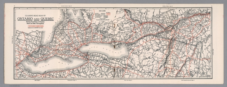
Author
Clason Map Company
Full Title
Clason's Road Map of Ontario and Quebec. Showing paved roads, All weather roads and other throughfares. (U.S. Highways shown in red.) Published by the Clason Map Co., Denver. Copyrighted Clason Map. All rights reserved. Map No. R-305A.
List No
4423.025
Note
Color map. Includes road legend.
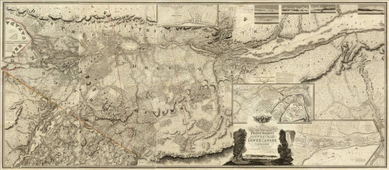
Author
[Bouchette, Joseph, Faden, William, 1750?-1836]
Full Title
(Covers to) (Description Topographique du Bas Canada) (with) To His Royal Highness George Augustus Frederick ... This Topographical Map of the Province of Lower Canada, Shewing its division into Districts, Counties, Seigniories, & Townships ... Is ... Most Gratefully Dedicated ... Joseph Bouchette, His Majesty's Surveyor General of the Province & Lieutt. Colonel C.M. ... Published by W. Faden, Charing Cross, Augst. 12th 1815. Engraved by J. Walker & Sons, 47 Bernard Street, Russell Square, London. (with) Map of the Provinces of Upper & Lower Canada with the Adjacent Parts of the United States of America &c. Compiled from the latest Surveys and Adjusted from the most recent and Approved Astronomical Observations by Joseph Bouchette ... Augst 12th, 1815, by W. Faden ... (with) Plan of the District of Gaspe ... Augst 12th, 1815 ...
List No
4431A
Note
This is an atlas of three maps on 13 sheets: the large map of Lower Canada on ten sheets (scale 1:174,240, size 133x307); the map of Upper and Lower Canada on two sheets (scale 1:2,200,000, size 76x123); and the single sheet map of Gaspe (scale 1:506,880, size 40x48). These maps were intended to accompany Bouchette's Topographical Description of Lower Canada (see our copy). The first two maps have outline color. Atlas is bound into half leather marbled paper covered boards. The title on the atlas spine "Description Topograph du Bas Canada" may indicate that this atlas was issued to accompany the 1815 French edition of the book published in London (Sabin 6850). The large ten sheet map is extraordinary - it is over ten feet long when joined and almost five feet tall. It has five views and three large inset maps of Montreal, Quebec, and Three Rivers. The detail and graphic elegance of the large map is the equal (or perhaps the superior) of any of the contemporary maps that we have seen (and none of which are on such a large scale - the only potential candidate would be Eddy's Map of the Country Thirty Miles Round the City of New York). Of course the engraving was done by the Walker firm in London, whose resources were up to the New York and Philadelphia engravers, or better, so a comparison with American produced maps is not entirely fair. Bouchette's work as Surveyor General must have instilled in him an obsession with the accuracy and fineness of detail that one sees in these maps.
Author
[Bouchette, Joseph, Faden, William, 1750?-1836]
Full Title
(Composite of) To His Royal Highness George Augustus Frederick ... This Topographical map of the Province of Lower Canada, shewing its division into Districts, Counties, Seigniories, & Townships ... Is ... Most gratefully dedicated by ... Joseph Bouchette, His Majesty's Surveyor General of the Province & Lieutt. Colonel C.M. ... Published by W. Faden, Charing Cross, Augst. 12th. 1815. Engraved by J. Walker & Sons, 47 Bernard Street, Russell Square, London. J. Walker sculp. (with) Town of Three Rivers. (with) City of Quebec. (with) Town of Montreal ...
List No
4431.011
Note
Engraved map on 10 sheets. Boundaries outlined in color by hand. Includes 5 five views and three large inset maps of Montreal, Quebec, and Three Rivers. Relief shown by hachures; depths by soundings. Shows buildings in cities.
Author
[Bouchette, Joseph, Faden, William, 1750?-1836]
Full Title
(Composite of eastern sheets) To His Royal Highness George Augustus Frederick ... This Topographical map of the Province of Lower Canada, shewing its division into Districts, Counties, Seigniories, & Townships ... Is ... Most gratefully dedicated by ... Joseph Bouchette, His Majesty's Surveyor General of the Province & Lieutt. Colonel C.M. ... Published by W. Faden, Charing Cross, Augst. 12th. 1815. Engraved by J. Walker & Sons, 47 Bernard Street, Russell Square, London. J. Walker sculp. (with) Town of Three Rivers. (with) City of Quebec. (with) Town of Montreal ...
List No
4431.013
Note
Four easternmost sheets of 10-sheet engraved map. Includes views, and ornamental cartouche. Relief shown by hachures; depths by soundings. Shows buildings in cities.
Author
[Bouchette, Joseph, Faden, William, 1750?-1836]
Full Title
(To His Royal Highness George Augustus Frederick ... This Topographical map of the Province of Lower Canada, shewing its division into Districts, Counties, Seigniories, & Townships. Sheet) A (... Is ... Most gratefully dedicated by ... Joseph Bouchette, His Majesty's Surveyor General of the Province & Lieutt. Colonel C.M. ... Published by W. Faden, Charing Cross, Augst. 12th. 1815. Engraved by J. Walker & Sons, 47 Bernard Street, Russell Square, London)
List No
4431.001
Note
Upper left sheet of engraved map on 10 sheets. Relief shown by hachures. Shows buildings, parcel boundaries, etc. Includes 2 distance tables.
Author
[Bouchette, Joseph, Faden, William, 1750?-1836]
Full Title
(To His Royal Highness George Augustus Frederick ... This Topographical map of the Province of Lower Canada, shewing its division into Districts, Counties, Seigniories, & Townships. Sheet) E (... Is ... Most gratefully dedicated by ... Joseph Bouchette, His Majesty's Surveyor General of the Province & Lieutt. Colonel C.M. ...). Published by W. Faden, Charing Cross, Augst. 12th. 1815. (Engraved by J. Walker & Sons, 47 Bernard Street, Russell Square, London)
List No
4431.002
Note
Lower left sheet of engraved map on 10 sheets. Relief shown by hachures. Shows buildings, parcel boundaries, etc. Includes distance table.
Author
[Bouchette, Joseph, Faden, William, 1750?-1836]
Full Title
(To His Royal Highness George Augustus Frederick ... This Topographical map of the Province of Lower Canada, shewing its division into Districts, Counties, Seigniories, & Townships. Sheet) A-B (... Is ... Most gratefully dedicated by ... Joseph Bouchette, His Majesty's Surveyor General of the Province & Lieutt. Colonel C.M. ...). Published by W. Faden, Charing Cross, Augst. 12th. 1815. (Engraved by J. Walker & Sons, 47 Bernard Street, Russell Square, London)
List No
4431.003
Note
One sheet of engraved map on 10 sheets. Relief shown by hachures. Shows buildings, parcel boundaries, etc. Includes distance table.
Author
[Bouchette, Joseph, Faden, William, 1750?-1836]
Full Title
(To His Royal Highness George Augustus Frederick ... This Topographical map of the Province of Lower Canada, shewing its division into Districts, Counties, Seigniories, & Townships. Sheet) E-F (... Is ... Most gratefully dedicated by ... Joseph Bouchette, His Majesty's Surveyor General of the Province & Lieutt. Colonel C.M. ... Published by W. Faden, Charing Cross, Augst. 12th. 1815. Engraved by J. Walker & Sons, 47 Bernard Street, Russell Square, London)
List No
4431.004
Note
One sheet of engraved map on 10 sheets. Relief shown by hachures. Shows buildings, parcel boundaries, etc. Includes distance table.
|