|
REFINE
Browse All : National Atlas of Ohio River
1-6 of 6
Author
[Collot, George Henri Victor, Tardieu, P.F.]
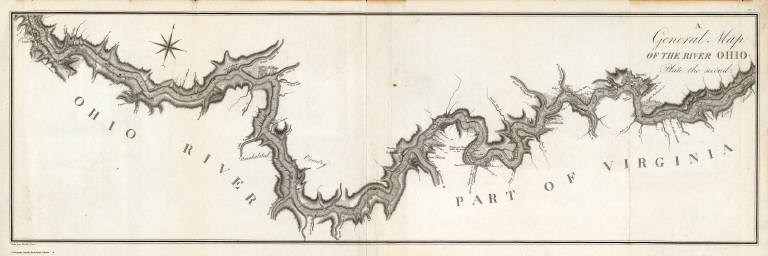
Full Title
A General Map of the River Ohio, Plate the first. Grave par Tardieu l'aine. PL. 8.
List No
4664.006
Note
These four maps show the Ohio River from Pittsburgh to the Mississippi, at a very large scale, and would make a map over ten feet long if joined end to end. These maps of the Ohio are the best and most original maps in the atlas: "The beautifully executed map of the Ohio River depicts vividly the wilderness that this country was at the time of his journey" (Wagner Camp). The level of detail is great: individual farms are shown with the owner's names, soundings for the entire river length, towns and villages, swamps, natural curiosities, rapids, and much else. When compared with Zadock Cramer's maps of the river in his "Navigator," the Collot maps are much superior, containing far more information on the river depths and surrounding shores and islands. Thomas Hutchins large map shows the Ohio well, but only at about one fourth the scale of the Collot maps; Andrew Ellicott's two maps of the river, at about one third the Collot scale, leave large stretches to conjecture. As an 1805 printing of a 1796 journey, these maps are without equal in depicting the early settlements on the Ohio. Without color.
Author
[Collot, George Henri Victor, Tardieu, P.F.]
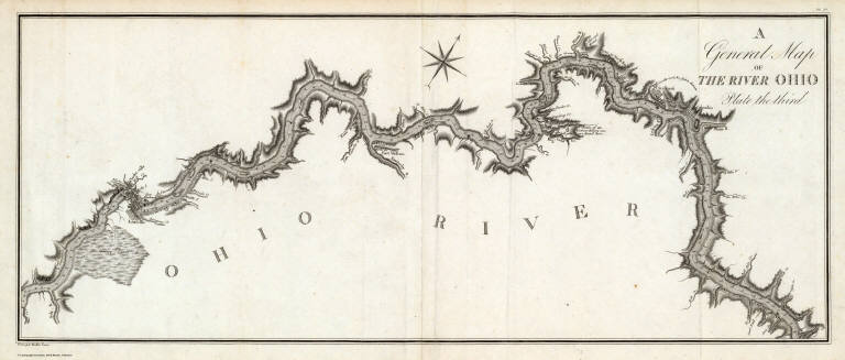
Full Title
A General Map of the River Ohio, Plate the second. Grave par Tardieu l'aine. PL. 9.
List No
4664.007
Note
These four maps show the Ohio River from Pittsburgh to the Mississippi, at a very large scale, and would make a map over ten feet long if joined end to end. These maps of the Ohio are the best and most original maps in the atlas: "The beautifully executed map of the Ohio River depicts vividly the wilderness that this country was at the time of his journey" (Wagner Camp). The level of detail is great: individual farms are shown with the owner's names, soundings for the entire river length, towns and villages, swamps, natural curiosities, rapids, and much else. When compared with Zadock Cramer's maps of the river in his "Navigator," the Collot maps are much superior, containing far more information on the river depths and surrounding shores and islands. Thomas Hutchins large map shows the Ohio well, but only at about one fourth the scale of the Collot maps; Andrew Ellicott's two maps of the river, at about one third the Collot scale, leave large stretches to conjecture. As an 1805 printing of a 1796 journey, these maps are without equal in depicting the early settlements on the Ohio. Without color.
Author
[Collot, George Henri Victor, Tardieu, P.F.]
Full Title
A General Map of the River Ohio, Plate the third. Grave par Tardieu l'aine. PL. 10.
List No
4664.008
Note
These four maps show the Ohio River from Pittsburgh to the Mississippi, at a very large scale, and would make a map over ten feet long if joined end to end. These maps of the Ohio are the best and most original maps in the atlas: "The beautifully executed map of the Ohio River depicts vividly the wilderness that this country was at the time of his journey" (Wagner Camp). The level of detail is great: individual farms are shown with the owner's names, soundings for the entire river length, towns and villages, swamps, natural curiosities, rapids, and much else. When compared with Zadock Cramer's maps of the river in his "Navigator," the Collot maps are much superior, containing far more information on the river depths and surrounding shores and islands. Thomas Hutchins large map shows the Ohio well, but only at about one fourth the scale of the Collot maps; Andrew Ellicott's two maps of the river, at about one third the Collot scale, leave large stretches to conjecture. As an 1805 printing of a 1796 journey, these maps are without equal in depicting the early settlements on the Ohio. Without color.
Author
[Collot, George Henri Victor, Tardieu, P.F.]
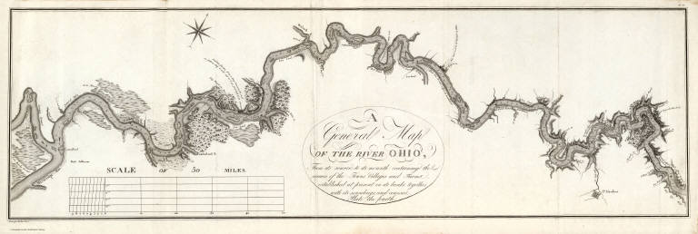
Full Title
A General Map Of The River Ohio, From its source to its mounth (sic): containing the names of the Towns Villages and Farms established at present on its banks: together with its soundings, and courses. Plate the fourth. Grave par Tardieu l'aine. PL. 11.
List No
4664.009
Note
This map contains the title cartouche for this map and the three proceeding. It also contains the scale measure. These four maps show the Ohio River from Pittsburgh to the Mississippi, at a very large scale, and would make a map over ten feet long if joined end to end. These maps of the Ohio are the best and most original maps in the atlas: "The beautifully executed map of the Ohio River depicts vividly the wilderness that this country was at the time of his journey" (Wagner Camp). The level of detail is great: individual farms are shown with the owner's names, soundings for the entire river length, towns and villages, swamps, natural curiosities, rapids, and much else. When compared with Zadock Cramer's maps of the river in his "Navigator," the Collot maps are much superior, containing far more information on the river depths and surrounding shores and islands. Thomas Hutchins large map shows the Ohio well, but only at about one fourth the scale of the Collot maps; Andrew Ellicott's two maps of the river, at about one third the Collot scale, leave large stretches to conjecture. As an 1805 printing of a 1796 journey, these maps are without equal in depicting the early settlements on the Ohio. Without color.
Author
[Collot, George Henri Victor, Tardieu, P.F.]
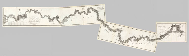
Full Title
(Composite of) A General Map Of The River Ohio, From its source to its mounth (sic): containing the names of the Towns Villages and Farms established at present on its banks: together with its soundings, and courses. (Plates one through four.) Grave par Tardieu l'aine. PL. 8-11.
List No
4664.010
Note
These four maps show the Ohio River from Pittsburgh to the Mississippi, at a very large scale, and would make a map over ten feet long if joined end to end. These maps of the Ohio are the best and most original maps in the atlas: "The beautifully executed map of the Ohio River depicts vividly the wilderness that this country was at the time of his journey" (Wagner Camp). The level of detail is great: individual farms are shown with the owner's names, soundings for the entire river length, towns and villages, swamps, natural curiosities, rapids, and much else. When compared with Zadock Cramer's maps of the river in his "Navigator," the Collot maps are much superior, containing far more information on the river depths and surrounding shores and islands. Thomas Hutchins large map shows the Ohio well, but only at about one fourth the scale of the Collot maps; Andrew Ellicott's two maps of the river, at about one third the Collot scale, leave large stretches to conjecture. As an 1805 printing of a 1796 journey, these maps are without equal in depicting the early settlements on the Ohio. Without color.
Author
[Collot, George Henri Victor, Tardieu, P.F.]
Full Title
Plan of the Rapids or Falls of the Ohio Latitude of Louisville. Grave par Tardieu l'aine. PL. 17.
List No
4664.012
Note
A lovely map of the area around Louisville and the Ohio River. Uncolored.
1-6 of 6
|