|
REFINE
Browse All : National Atlas of Kansas
1-45 of 45
Author
[Fisher, Joseph R., Planters Peanuts (Firm)]
Full Title
Minnesota : The gopher state -- Iowa : The hawkeye state -- Missouri : The show me state -- Kansas : The sunflower state.
List No
14374.011
Note
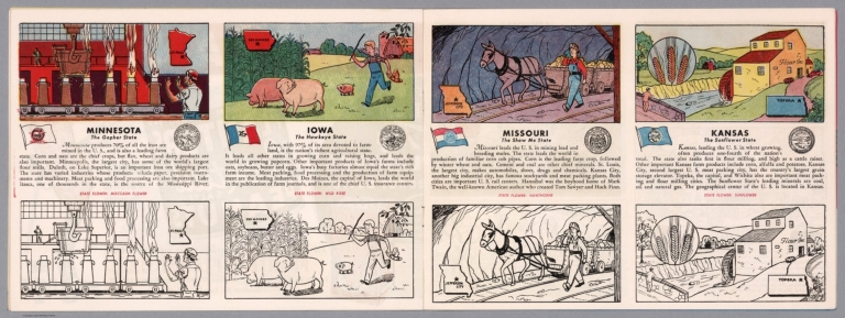
Four views, representing Minnesota, Iowa, Missouri and Kansas. Views show examples of the landscape and natural resources. Each view includes an inset map of the state, which marks the location of the capital city with a star. Accompanied by descriptive text, the state flags, seals and flowers: moccasin flower, wild rose, hawthorne and sunflower, respectively. The view of each state appears both in color (on top) and in black and white (bottom), the latter inviting coloration. Together, views are 18 x 52 cm, on two sheets 20 x 54 cm.
Author
Arbuckle Bros.
Full Title
Territory of Wyoming, Alabama, Louisiana, Kansas. Copyright 1889 Arbuckle Bros. N.Y.
List No
0027.011
Note
Sheet with maps of four states in full color. Wyoming's information includes a long paragraph on Yellowstone National Park, which is noted on the card as well. It is mentioned that in Louisiana, yellow fever epidemics swept through the state in 1853, 1867 and 1878. Each card measures 7.5 x 12.5 cm.
Author
Asher & Adams
Full Title
Asher & Adams' Kansas. Entered according to Act of Congress in the year 1874 by Asher & Adams ... at Washington. (New York, 1874)
List No
0041.026
Note
Hand col. engraved map. Shows townships, distances along railroads, etc. Prime meridians: Greenwich and Washington.
Author
Asher & Adams
Full Title
Asher & Adams' Nebraska. Entered according to Act of Congress in the year 1874 by Asher & Adams ... at Washington. (New York, 1874)
List No
0041.027
Note
Hand col. engraved map. Shows townships, distances along railroads, etc. Prime meridians: Greenwich and Washington.
Author
[Gray, Frank A., Gray, O.W.]
Full Title
Gray's New Map of Kansas by Frank A. Gray. Entered ... 1881 by O.W. Gray & Son.
List No
0312.047
Author
U.S. General Land Office
Full Title
(12) Map Showing the progress of the Public surveys in Kansas and Nebraska. 1866. Surveyor General's Office, Leavenworth, Kansas, August 25th, 1866. Department of the Interior, General Land Office, October 2nd 1866. Jo. S. Wilson, Commissioner. No. 15. Bowen & Co. lith. Philada.
List No
1070.015
Note
In outline color with the land offices in pink and the surveyor general's office in green. The legend includes coal, lead, platina, marble, and salt lands.
Author
U.S. General Land Office
Full Title
Department of the Interior, General Land Office. S.S. Burdett, Commissioner. State of Kansas. 1876. Compiled from the official records of the General Land Office and other sources by C. Roeser, Principal Draughtsman G.L.O. Photolith. & Print by Julius Bien 16 & 18 Park Place, N.Y.
List No
11179.005
Note
Color map. Includes references. Relief shown by hachures. Prime meridian is Greenwich.
Author
Rand McNalley & Company
Full Title
Rand McNally road map : Kansas.
List No
14003.024
Note
Road map of Kansas, showing interstate and state highways, paved and dirt roads, as well as drainage and ports, and state and national parks. Includes compass rose, time zones, and bar scale with scale statement: One inch equals approximately 19.5 miles. Features legend indicating population. Copyright by Rand McNally & Company, Chicago, Ill. Lithographed in the U.S.A.
Author
[Bates, Ernest Sutherland, 1879-1939, Schiff, Herman S., Reeves, Norman, Smith, Robert E.]
Full Title
Kansas, 1861.
List No
14244.077
Note
Pictorial map of Kansas, showing political boundaries with bordering states and major rivers. Features natural resources and manufactured items (including wheat, cheese, oil and private planes). Includes a compass rose and a scroll listing notable places and events - such as Pioneer Days, Leavenworth - which are pictured in vignettes below map, in order of listing. Map is 17 x 29 cm, on sheet 23 x 29 cm. Accompanied by historical text on facing page.
Author
Bradstreet Company
Full Title
Kansas. (to accompany) Bradstreet's Pocket Atlas Of The United States. Published Exclusively for Macullar, Parker & Company, Boston, Massachusetts ... New York: The Bradstreet Company, 1885. (on verso) Entered ... 1879, by The Bradstreet Company ... Washington.
List No
2054.048
Note
Full color map. Prime meridian is Washington, D.C.
Author
Rand McNally and Company
Full Title
(Text Page) Louisiana. Kansas.
List No
2094CT
Note
List of geographical features indexed to map.
Author
Rand McNally and Company
Full Title
(Text Page) Kansas.
List No
2094CU
Note
List of geographical features indexed to map.
Author
Rand McNally and Company
Full Title
Rand, McNally & Co.'s Kansas.
List No
2094.046
Note
Counties outlined in color. Meridians Washington and Greenwich. Railroads highlighted. Relief shown by hachures.
Author
Rand McNally and Company
Full Title
(Text Page) Kansas. Nebraska.
List No
2094CV
Note
List of geographical features indexed to map.
Author
[Lloyd, H.H., Warner & Beers]
Full Title
Atlas of the United States, Map of Utah, Arizona, New Mexico, Kansas, Colorado, and Indian Territory. Warner & Beers, Publishers. From H.H. Lloyd & Co.'s Atlas of the United States.
List No
2585.076
Note
Relief shown in hachures.
Author
Rand McNally and Company
Full Title
(Text Page) Rand, McNally Co.'s Oklahoma. Rand, McNally Co.'s Kansas.
List No
2844DG
Note
Tables of railroads and geographical features keyed to map.
Author
Rand McNally and Company
Full Title
Rand, McNally & Co.'s Kansas.
List No
2844.065
Note
Tables of railroads and chief cities keyed to map. Inset extension of map.
Author
Rand McNally and Company
Full Title
(Text Page) Rand, McNally Co.'s Kansas.
List No
2844DH
Note
Tables of geographical features keyed to map.
Author
Rand McNally and Company
Full Title
(Text Page) Rand, McNally Co.'s Kansas.
List No
2844DI
Note
Tables of geographical features keyed to map.
Author
Smith, J. Calvin
Full Title
(Nebraska, Kansas, Iowa, Missouri).
List No
3471.005
Note
Estimated Date. Part of a sixteen piece map combined digitally as a composite in final map of series.
Author
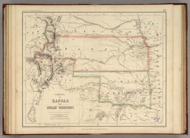
[Johnston, Alexander Keith, 1804-1871, Rogers, Henry Darwin]
Full Title
Territory of Kansas And Indian Territory. By Prof. H.D. Rogers & A. Keith Johnston, F.R.S.E. Entered in Sta. Hall. London ... & according to an act of Congress ... 1857, by H.D. Rogers ... Massachusetts. London, John Murray, Albemarle Street, Edinburgh, W. & A.K. Johnston. Engraved by W. & A.K. Johnston, Edinburgh.
List No
3825.013
Note
Kansas and Indian Territory (Oklahoma) are shown in printed outline color with proposed railway routes in purple.
Author
National Map Company
Full Title
Kansas. (Copyrighted by) National Map Company, Indianapolis. (to accompany) Official Paved Road and Commercial Survey of the United States.
List No
4048.039
Note
Outline color map. Shows administrative divisions, roads, rivers, etc. Prime meridian is Greenwich.
Author
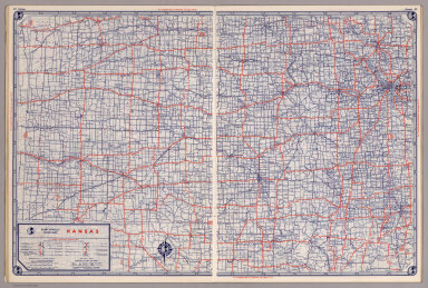
State Farm Insurance Companies Travel Bureau
Full Title
State Farm Road map: Kansas. Copyright by Rand McNally & Company, Chicago, Ill. Lithographed in U.S.A. Z.3610. (on upper corners) Kansas.
List No
4246.025
Note
Color map. Shows roads, points of interest, distances, time zone boundaries, populations, etc. U.S. interstate and principal state highways shown in red.
Author
Clason Map Company
Full Title
Clason's Road Map of Kansas. Showing paved roads, All weather roads and other throughfares. (U.S. Highways shown in red.) Published by the Clason Map Co., Denver. Copyrighted Clason Map. All rights reserved. Map No. R-212A.
List No
4423.037
Note
Color map. Includes road legend, and Index of cities and towns giving populations and Key to map.
Author
Rand McNally and Company
Full Title
Rand, McNally & Co.'s Kansas.
List No
4520.041
Note
States in outline color by county. Relief shown by hachures. Shows named railroads. Prime meridians: Greenwich and Washington.
Author
Cram, George Franklin
Full Title
Cram's Rail Road & Township Map of Kansas.
List No
4533.007
Author
Asher & Adams
Full Title
Asher & Adams' Kansas. Entered according to Act of Congress 187? by Asher & Adams in the Office of the Librarian of Congress at Washington. (1975)
List No
4977.052
Note
Washington Meridian. Hand tinted full color. Shows railroads, settlements, counties, waterways, and lakes. Engraved.
Author
Rand McNally and Company
Full Title
(Text Page) Industrial Statistics of the United States. Iowa. Kansas.
List No
5028Z
Note
Industrial statistics by state and county including county seat, area, and statistics on population, agriculture and manufacturing. Includes descriptions of mines, quarries, and wells.
Author
Rand McNally and Company
Full Title
Commercial Atlas of America. Rand McNally AutoTrails Map, District Number 10, Iowa, E.Nebraska, S. Minnesota, N. Missouri, N.E. Kansas, W. Illinois.
List No
5028.104
Note
Shows roads and distances. Shows table of highway names, numbers, and markings.
Author
Rand McNally and Company
Full Title
Commercial Atlas of America. Rand McNally Standard Map of Kansas.
List No
5028.108
Note
Shows railroads and distances. Includes tables of principal cities and railroads, keyed to map.
Author
Rand McNally and Company
Full Title
(Text Page) Kansas - Counties, Creeks, Rivers, Towns, Etc.
List No
5028DH
Note
Geographical features keyed to map; populations of towns. Shows electric lines.
Author
Rand McNally and Company
Full Title
Commercial Atlas of America. Rand McNally AutoTrails Map, District Number 12, Southern Nebraska, Eastern Colorado, Kansas, N.E. New Mexico, Northern Oklahoma.
List No
5028.109
Note
Shows roads and distances. Shows table of highway names, numbers, and markings.
Author
Rand McNally and Company
Full Title
(Text Page) Kansas - Counties, Creeks, Rivers, Towns, Etc.
List No
5028DI
Note
Geographical features keyed to map; populations of towns. Shows electric lines.
Author
Rand McNally and Company
Full Title
Commercial Atlas of America. Rand McNally Black and White Mileage Map, Kansas.
List No
5028.110
Note
Shows railroads and distances.
Author
Mitchell, Samuel Augustus Jr.
Full Title
County & Township Map of the States of Kansas and Nebraska. Entered ... 1874 by S. Augustus Mitchell ... Washington.
List No
5041.038
Note
Prime meridians are Washington D.C. and Greenwich.
Author
Cram, George Franklin
Full Title
Cram's Rail Road & Township Map of Kansas. Published by Geo. F. Cram. Proprietor of the Western Map Depot. 66, Lake St. Chicago Ills. 1875.
List No
5370.017
Note
Map in full color by county. The railroad lines are clearly marked. (Note: The map has been rotated 90 degrees clockwise for readability.)
Author
Colton, G.W.
Full Title
Nebraska and Kansas. No. 50. Published by J.H. Colton & Co., No 172 William St., New York. Entered according to the Act of Congress in the year 1855 by J.H. Colton & Co. in the Clerk's Office of the District Court of the United States for the Southern District of New York.
List No
5479.097
Note
Meridians Washington and Greenwich. Tinted in color.
Author
Rand McNally and Company
Full Title
Rand McNally junior auto road map Kansas. Copyright by Rand McNally & Co., Chicago, Ill. (1927)
List No
5755.026
Note
Color map. Shows settlements, classified roads with distances, etc. "I-32."
Author
Rand McNally and Company
Full Title
Chicago and vicinity. Omaha and vicinity. Kansas City and vicinity. Copyright by Rand McNally & Co., Chicago, Ill. (1927)
List No
5755.048
Note
Three maps on facing pages. In blue ink. Show settlements, classified roads with distances, etc.
Author
Shell Oil Company
Full Title
Shell Map of Kansas (cover title). Shell Highway Map of Kansas. 9-X-1950-1.
List No
5840.035
Author
Shell Oil Company
Full Title
Wichita. Topeka. Hutchinson. Salina. Kansas City and Vicinity. (Verso to) Shell Highway Map of Kansas.
List No
5840.036
Author
[State Farm Insurance Companies Travel Bureau, Rand McNally and Company]
Full Title
Rand McNally Road map, Kansas. Copyright by Rand McNally & Company, Chicago, Ill. Lithographed in the U.S.A. (to accompany) State Farm Road Atlas: United States, Canada, Mexico,Central and South America. Copyright 1940 by Rand McNally & Company, Chicago, Ill.
List No
5969.032
Note
Color map. U.S. interstate highways shown in red. Shows roads, capitals, population of cities and towns, Indian reservations, etc. Relief shown by hachures and spot heights.
Author
[Rand McNally and Company, State Farm Insurance Companies Travel Bureau]
Full Title
Rand McNally Road map: Kansas. Copyright by Rand McNally & Company, Chicago, Ill. Lithorgaphed in the U.S.A. U.3610. (to accompany) State Farm road atlas : United States, Canada, Mexico.
List No
6825.029
Note
Color map. U.S. interstate highways shown in red. Shows time zone boundaries, roads, ferries, highways, rivers and streams. Includes population of cities and towns.
Author
[Taylor, Frank J., White, Ruth Taylor]
Full Title
Kansas.
List No
7823.042
Author
[Hader, Berta Hoerner (1890-1976), Hader, Elmer Stanley (1889-1973]
Full Title
Kansas. Nebraska.
List No
8763.046
1-45 of 45
|