|
Author
[Fisher, Joseph R., Planters Peanuts (Firm)]
Full Title
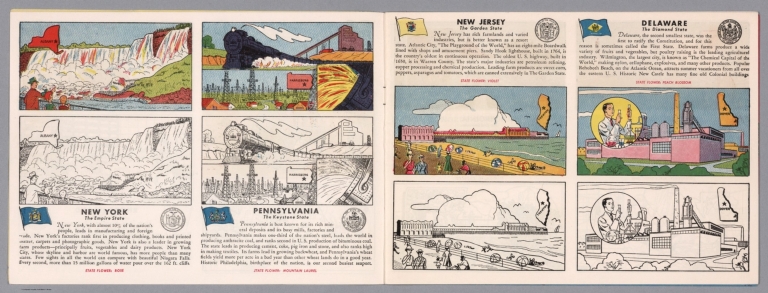
New York : The empire state -- Pennsylvania : The keystone state -- New Jersey : The garden state -- Delaware : The diamond state.
List No
14374.005
Note
Four views, representing New York, Pennsylvania, New Jersey and Delaware. Views show examples of the landscape and natural resources. Each view includes an inset map of the state, which marks the location of the capital city with a star. Accompanied by descriptive text, the state flags, seals and flowers: rose, mountain laurel, violet and peach blossom, respectively. The view of each state appears both in color (on top) and in black and white (bottom), the latter inviting coloration. Together, views are 18 x 52 cm, on two sheets 20 x 54 cm.
Author
Arbuckle Bros.
Full Title
New York, Delaware, Tennessee, New Hampshire. Copyright 1889 Arbuckle Bros. N.Y.
List No
0027.009
Note
Sheet with maps of four states in full color. It is stated that New York leads all of its "sister states" in manufacturing with the value of its products at approximately $1 billion. Tennessee is known as one of the healthiest states in the Union. Delaware leads the nation in its production of peaches. Each card measures 7.5 x 12.5 cm.
Author
Asher & Adams
Full Title
Asher & Adams' Delaware, Maryland, Virginia, West Virginia & District of Columbia. Entered according to Act of Congress in the year 1874 by Asher & Adams ... at Washington. (New York, 1874)
List No
0041.008
Note
Hand col. engraved map. Relief shown by hachures. Shows distances along railroads, etc. Prime meridians: Greenwich and Washington.
Author
[Bartholomew, John, Black, Adam & Charles]
Full Title
Virginia, Maryland & Delware. Published by A. & C. Black. Edinburgh. Printed in Colours by Schenck & Macfariane. Edinburgh. Drawn & Engraved by J. Bartholomew, Edinburgh.
List No
0073.010
Note
States outlined in color. Land tinted.
Author
Bradford, Thomas G.
Full Title
Delaware. Entered ... 1838, by T.G. Bradford ... Massachusetts. Drawn by F. Lucas, Jr. Engraved by G.W. Boynton.
List No
0089.022
Note
In full color.
Full Title
Carte geographique, statistique et historique du Delaware. Delaware. Fonderie et Imprimerie de J. Carez. (1825)
List No
0102.019
Note
Hand colored engraved map. Relief shown by hachures. Text and tables at sides and bottom. Prime meridians: Washington and Paris.
Author
Burr, David H., 1803-1875
Full Title
Map of Virginia, Maryland and Delaware Exhibiting the Post Offices, Post Roads, Canals, Rail Roads, &c. By David H. Burr. (Late Topographer to the Post Office.) Geographer to the House of Representatives of the U.S. John Arrowsmith. Entered ... July 10th, 1839, by David H. Burr ... District of Columbia.
List No
0104.005
Note
In full color by county. Postal routes by coach, stage, sulkey, cross, rail roads and canals shown. In 8 sections mounted on linen. Label on back states "No. 5. Delaware, Maryland, Virginia."
Author
[Carey, H. C., Lea, I.]
Full Title
Geographical, Historical, And Statistical Map Of Delaware. Delaware. No. 19. Drawn by F. Lucas Jr. Engraved by Young & Delleker.
List No
0122.014
Note
In full color by county surrounded by text.
Author
Finley, Anthony
Full Title
Map Of Pennsylvania New Jersey And Delaware Constructed from the Latest Authorities 1825. D.H. Vance del. J.H. Young Sc. Published by A. Finley Philada.
List No
0278.006
Note
In full color by county with broad lines of color between states. Statistical table details population by county in 1810 and 1820. Square mileage by state also included.
Author
Finley, Anthony
Full Title
Map of Pennsylvania, New Jersey, and Delaware, Constructed from the Latest Authorities.
List No
0279.010
Note
Date estimated.
Author
Finley, Anthony
Full Title
Map of Pennsylvania, New Jersey, and Delaware, Constructed from the Latest Authorities. Drawn by D.H. Vance. Published by A. Finley, Philada. Engraved by J.H. Young.
List No
0280.006
Note
Relief shown by hachures. Prime meridian Washington. Statistical table for state.
Author
[Gray, Frank A., Gray, O.W.]
Full Title
Maryland, Delaware and the District of Columbia by Frank A. Gray. Copyright 1876 by O.W. Gray & Son. (inserts) Washington (D.C.). Wilington, Delaware. Annapolis. Annapolis Harbor and Environs.
List No
0312.020
Author
Melish, John
Full Title
Map of the American Coast, from Lynhaven Bay to Narraganset Bay, by John Melish.
List No
0495.002
Note
Fold-out map in outline color stretching from Long Island Sound to Norfolk, Virginia.
Author
[Reid, John, Winterbotham, W.]
Full Title
The States of Maryland and Delaware, from the latest Surveys. 1795. D. Martin scupt. Published by Wayland, Reid & Smith. (with inset) Continuation of the Potowmac River from Fort Cumberland.
List No
0845.013
Note
Uncolored.
Author
Rand McNalley & Company
Full Title
Rand McNally road map : Delaware -- Maryland -- Virginia -- West Virginia.
List No
14003.017
Note
Road map of Delaware, Maryland, Virginia and West Virginia, showing interstate and state highways, paved and dirt roads, ferries and boatlines, as well as state and national parks. Includes compass rose, time zones, and bar scale with scale statement: One inch equals approximately 19.5 miles. Features legend indicating population. Copyright by Rand McNally & Company, Chicago, Ill. Lithographed in the U.S.A.
Author
[Bates, Ernest Sutherland, 1879-1939, Schiff, Herman S., Reeves, Norman, Smith, Robert E.]
Full Title
Delaware, 1776.
List No
14244.035
Note
Pictorial map of Delaware, showing political boundaries with bordering states and coastline. Features natural resources and manufactured items (including grapes, turtles and munitions). Includes a compass rose and a scroll listing notable places - such as Obelisk Chimney - which are pictured in vignettes to the right of map, in order of listing. Map is 22 x 20 cm, on sheet 23 x 29 cm. Accompanied by historical text on facing page.
Author
Bradstreet Company
Full Title
Delaware, Maryland. (to accompany) Bradstreet's Pocket Atlas Of The United States. Published Exclusively for Macullar, Parker & Company, Boston, Massachusetts ... New York: The Bradstreet Company, 1885. (on verso) Entered ... 1879, by The Bradstreet Company ... Washington.
List No
2054.025
Note
Full color map. Relief shown by hachures. Prime meridian is Washington, D.C.
Author
[Breese, Samuel, 1802-1873, Morse, Sidney E. (Sidney Edwards), 1794-1871]
Full Title
Maryland and Delaware. (with) District of Columbia. (By Sidney E. Morse and Samuel Breese. New York: Published by Harper & Brothers, 1845)
List No
2301.017
Note
Col. wax engraved map. Relief shown by hachures. Includes profiles of the Baltimore and Ohio Canal and Baltimore and Ohio Railroad. Prime meridians: Greenwich and Washington.
Author
Poussin, Guillaume Tell, 1794-1876
Full Title
Plan du canal de jonction du Mississippi au Lac Pontchartrain. (with) Canal de Louisville. Profil moyen sur lequel a ete calcule de devis estimatif. (with) Canal de la Chesapeake a la Delaware. Plan du trace, situation des ecluses, nivellement general et profil du canal. Dessine par le Major Poussin. Grave par (V.?) Adam. (1834)
List No
2329.003
Note
Engraved map with 2 insets. Soundings in English feet.
Author
Poussin, Guillaume Tell, 1794-1876
Full Title
Plan hydrographique de la partie de la Baie de la Delaware qui avoisine le breakwater ou port artificiel que l'on y a construit. (with) Plan general de la Baie de la Delaware et de la position occupee par le port artificiel construir a son embouchure. (with) Plan general de la Baie et du breakwater de Plymouth. (with) Plan general de la rade et de la Baie de Cherbourg. (with) Section transversale du breakwater ou jetee de Plymouth. (with) Section transversale de la Digue de Cherbourg et profil de l'enrochment de 1784. (with) Section transversale du breakwater ou jetee de la Delaware. Dessine par le Major Poussin. Grave par (V.?) Adam. (1834)
List No
2329.006
Note
Engraved map with 6 insets. Soundings in English fathoms. Numbered Fig. 1-7.
Author
Henshaw, Frances A.
Full Title
Delaware.
List No
2501.011
Note
State in outline color.
Author
Henshaw, Frances A.
Full Title
(Description of) Delaware.
List No
2501M
Note
The description of Delaware is quite extensive. It notes the existence of numerous religious denominations including the Presbyterians, Episcopalians, Methodists, and the Swedish church.
Author
Carey, Mathew
Full Title
Delaware, from the best Authorities. W. Barker, sculp. Philada. Engraved for Carey's American Edition of Guthrie's Geography improved.
List No
2542.011
Note
Uncolored.
Author
Lange, Henry, 1821-1893.
Full Title
Der Bundesdistrict Columbia, Virginien, Nord-Carolina, Maryland, u. Delaware. (with inset map) Der Bundesdistrict Columbia. H. Lange's Atlas v. Nord Amerika Blatt IV. Braunschweig: Verlag v. George Westermann. Lith. Anst. von L. Kraatz in Berlin.
List No
2743.004
Note
Engraved map. Borders hand col. Shows roads, canals, railroads, etc. Relief shown by hachures. Scale of inset map (ca. 1:370,000)
Author
Tanner, Henry S.
Full Title
Virginia, Maryland And Delaware. (to accompany) A New Pocket Atlas of the United States With The Roads and Distances, Designed For the Use of Travelers. By H.S. Tanner. Philadelphia: Published by the Author. 1828. (on verso) ...on the seventeenth day of November ... 1828, Henry S. Tanner ... hath deposited ... a book ... Pennsylvania.
List No
2782.008
Note
Outline colored map. Prime meridian is Washington, D.C. Rare. Same maps used in Darby's View of U.S. Although this appears in Tanner's catalogues for several years after 1828, it must not have sold well, as few copies have survived. Bound with half leather and paper covered boards. "Pocket Atlas" embossed on spine.
Author
Melish, John
Full Title
Map of the American Coast, from Lynhaven Bay to Narraganset Bay, by John Melish.
List No
2788.006
Note
Fold-out map in outline color stretching from Long Island Sound to Norfolk, Virginia.
Author
Rand McNally and Company
Full Title
Rand, McNally & Co.'s Maryland, D.C. and Delaware. (with) Baltimore and Environs.
List No
2844.027
Note
Relief shown by hachures. Railroads and chief cities listed and keyed to map.
Author
Rand McNally and Company
Full Title
(Text Page) Rand, McNally Co.'s Delaware and District of Columbia. Rand, McNally Co.'s Virginia.
List No
2844AO
Note
Tables of railroads and geographical features keyed to map.
Author
Mitchell, Samuel Augustus
Full Title
Map Of Pennsylvania, New Jersey And Delaware. Constructed from the Latest Authorities. Published by S. Augustus Mitchell Philadelphia. 1831. Engraved by J.H. Young.
List No
3884.006
Note
Full color by county.
Author
National Map Company
Full Title
Maryland, Delaware and District of Columbia. (Copyrighted by) National Map Company, Indianapolis. (to accompany) Official Paved Road and Commercial Survey of the United States. (insets) District of Columbia and vicinity. And Washington: the National Capital ; City of Baltimore and vicinity.
List No
4048.025
Note
Outline color map with 2 insets. Shows administrative divisions, roads, rivers, etc. Prime meridian is Greenwich.
Author
[Morse, Sidney E. (Sidney Edwards), 1794-1871, Breese, S.]
Full Title
Maryland and Delaware. (to accompany) Supplement To The New-York Observer. The Cerographic Atlas Of The United States. By Sidney E. Morse, A.M. And Samuel Breese, A.M. New-York: Published By Sidney E. Morse & Co. 1842. [Entered ... 1841, by Sidney E. Morse and Samuel Breese ... New-York.] (inset) District of Columbia.
List No
4180.007
Note
Uncolored map. Shows state capital, county, towns, roads, railroads, rivers, canals, etc. Relief shown by hachures. Prime meridian is Washington. Includes explanation.
Author
Rand McNally and Company
Full Title
Rand McNally Junior Auto Road Map of Dealware, Maryland, Virginia, West Virginia. Copyright by Rand McNally & Company. Chicago, Ill. Made in U.S.A. P.1033.
List No
4245.007
Note
Color map. Includes explanation, and alphabetical index of cities and towns, giving populations and Key to map. U.S. interstate highways shown in red. Shows Highway markers.
Author
State Farm Insurance Companies Travel Bureau
Full Title
State Farm Road map: Delaware - Maryland - Virginia - West Virginia. Copyright by Rand McNally & Company, Chicago, Ill. Lithographed in U.S.A. Z.3617. (on upper corners) Del., Md., Va., W. Va. (inset) Western Virginia.
List No
4246.018
Note
Color map. Shows roads, points of interest, distances, time zone boundaries, populations, etc. U.S. interstate and principal state highways shown in red.
Author
Hillebrands, A.J.
Full Title
Atlas de Vereenigde Staten No. 4. Pennsylvania, New Jersey, Delaware, Maryland en Virginia.
List No
4323.006
Note
A scarce small atlas of ten maps published in Holland, but authored by a school teacher from the Dutch Colony in Holland, Michigan. It was most likely sold to Dutch Americans and those in Holland planning to emigrate or who had relatives in America. The date is estimated by Phillips and Koeman. Koeman lists an earlier edition of 1849, with five maps. There is a double page of text at the end of the maps, with lists of distances by steamboat and railroad. The copy listed in Phillips has a cover title, not present here. Maps are hand painted with outline color.
Author
Clason Map Company
Full Title
Clason's Road Map of Delaware, Maryland, Virginia, West Virginia. Showing paved roads, All weather roads and other throughfares. (U.S. Highways shown in red.) Published by the Clason Map Co., Denver. Copyrighted Clason Map. All rights reserved. Map No. R-274 A.
List No
4423.016
Note
Color map. Includes road legend, and Index of cities and towns giving 1930 Census populations and Key to map.
Author
Rand McNally and Company
Full Title
Rand, McNally & Co.'s Maryland, D.C., and Delaware.
List No
4520.019
Note
In outline color. Inset map of western Maryland. Shows named railroads. Prime meridians: Greenwich and Washington
Author
Cram, George Franklin
Full Title
Cram's Rail Road & County Map of Pennsylvania, Maryland, New Jersey & Delaware.
List No
4533.023
Author
[Morse, Sidney E. (Sidney Edwards), 1794-1871, Breese, Samuel]
Full Title
Maryland and Delaware. (inset) District of Columbia. (By Sidney E. Morse and Samuel Breese. New York: Published by Harper & Brothers, 1845). (to accompany) Morse's Cerographic Maps. No. VIII.
List No
4861.065
Note
Color wax engraved map. Shows capitals, towns, road, railroads, rivers, canals, etc. Includes explanation and profiles of the Baltimore and Ohio Canal and Baltimore and Ohio Railroad. Relief shown by hachures. Prime meridians are Greenwich and Washington.
Author
Carey, Mathew
Full Title
Delaware. Engraved by A. Doolittle Newhaven.
List No
4865.011
Note
Uncolored.
Full Title
Virginia, Maryland and Delaware. (with District of Columbia). (with Baltimore and vicinity). N. & S.S. Jocelyn Sc. (New-Haven: N. & S.S. Jocelyn. 1823)
List No
4869.006
Note
Engraved map with 2 insets and facing index page. Outline hand color. Relief shown by hachures. Prime meridians: Washington and Greenwich.
Author
[Hinton, Isaac Taylor, 1799-1847, Simpkin & Marshall]
Full Title
Map of the states of Virginia and Maryland. (with) Plan of Washington and Georgetown. London, published Sept. 1, 1831, by I.T. Hinton & Simpkin & Marshall. Engraved & printed by Fenner Sears & Co. (1832)
List No
4966.010
Note
Hand col. engraved map. Relief shown by hachures. Covers also Delaware. Prime meridians: Washington and Greenwich. "66."
Author
[Hinton, Isaac Taylor, 1799-1847, Simpkin & Marshall]
Full Title
Map of the states of Pennsylvania and New Jersey. (with) Plan of Philadelphia. London, published March 15, 1832 by I.T. Hinton & Simpkin & Marshall. Engraved & printed by Fenner Sears & Co. (1832)
List No
4966.013
Note
Hand col. engraved map. Relief shown by hachures. Covers also Delaware. Prime meridians: Washington and Greenwich. "92."
Author
Asher & Adams
Full Title
Asher & Adams' Delaware, Maryland, Virginia, West Virginia & District of Columbia. Entered according to Act of Congress 1874 by Asher & Adams in the Office of the Librarian of Congress at Washington.
List No
4977.018
Note
Washington Meridian. Hand tinted full color. Relief shown in hachures. Shows railroads, settlements, counties, waterways, and lakes. Engraved.
Author
Rand McNally and Company
Full Title
(Text Page) Industrial Statistics of the United States. Connecticut. Delaware. Dist. of Columbia. Florida. Georgia.
List No
5028X
Note
Industrial statistics by state and county including county seat, area, and statistics on population, agriculture and manufacturing. Includes descriptions of mines, quarries, and wells.
Author
Rand McNally and Company
Full Title
Commercial Atlas of America. Rand McNally Auto Trails Map. District No. 7. Pennsylvania, New Jersey, Southern New York, Northern Delaware, Northern Maryland, Northern Virginia, North East W. Virginia.
List No
5028.041
Note
Shows key to road numbers and trail markings.
Author
Rand McNally and Company
Full Title
Commercial Atlas of America. Rand McNally Standard Map of Maryland and Delaware. (with) Baltimore and Environs.
List No
5028.043
Note
List of railroads and principal cities keyed to map.
Author
Rand McNally and Company
Full Title
Commercial Atlas of America. Rand McNally Black and White Mileage Map, Maryland and Delaware.
List No
5028.045
Author
Rand McNally and Company
Full Title
(Text Page) Delaware - Counties, Bays, Cape, Creeks, Rivers, and Towns. District of Columbia - Towns. Maryland, Delaware and District of Columbia Electric Lines.
List No
5028BG
Note
Geographical features keyed to map; populations of towns. List of electric rail lines.
Author
Mitchell, Samuel Augustus Jr.
Full Title
County Map of Maryland and Delaware. County Map of New Jersey. Entered ... 1874 by S. Augustus Mitchell ... Washington.
List No
5041.016
Note
Relief shown by hachures. Prime meridians are Washington D.C. and Greenwich.
Author
Schonberg & Co.
Full Title
Schonberg's Map of Pennsylvania, New Jersey, Maryland and Delaware. Entered ... 1866 ...New York.
List No
5198.013
Note
Counties shown in color. Prime meridians Washington D.C. and Greenwich. Relief shown by hachures.
|