|
Author
[Instituto de Geografía (Academia de Ciencias de Cuba), Akademiia nauk SSSR. Institut geografii.]
Full Title
Politiko - Administrativnoye Deleniye, 1968. Natsional'nyi Atlas Kuby : V oznamenovanie desi︠a︡toy godovshchiny revoli︠u︡tsii; Gavana, 1970.
List No
13567.009
Note
Map of Cuba, shows political and administrative boundaries. Includes 2 insets: Politiko - Administrativnoye Deleniye do 1959g.; Skhema Politiko - Administrativnoye Deleniye, 1969.
Author
[Instituto de Geografía (Academia de Ciencias de Cuba), Akademiia nauk SSSR. Institut geografii.]
Full Title
Kuba i sosedniye strany. Natsional'nyi Atlas Kuby : V oznamenovanie desi︠a︡toy godovshchiny revoli︠u︡tsii; Gavana, 1970.
List No
13567.010
Note
Political map of Cuba and neighboring countries.
Author
[Instituto de Geografía (Academia de Ciencias de Cuba), Akademiia nauk SSSR. Institut geografii.]
Full Title
Provintsiya Pinar-del'-Rio. Natsional'nyi Atlas Kuby : V oznamenovanie desi︠a︡toy godovshchiny revoli︠u︡tsii; Gavana, 1970.
List No
13567.011
Note
Map of Pinar del Rio Province, with 2 insets: plan of the city of Pinar del Rio and Location map.
Author
[Instituto de Geografía (Academia de Ciencias de Cuba), Akademiia nauk SSSR. Institut geografii.]
Full Title
Provintsii Gavana, Matansas i Las-Vil'yas. Natsional'nyi Atlas Kuby : V oznamenovanie desi︠a︡toy godovshchiny revoli︠u︡tsii; Gavana, 1970.
List No
13567.012
Note
Map of the Havana, Matanza and Las Villas provinces. with 5 insets: City plans of Matanzas, Cienfuegos, La Habana, Santa Clara and Location map.
Author
[Instituto de Geografía (Academia de Ciencias de Cuba), Akademiia nauk SSSR. Institut geografii.]
Full Title
Provintsii Kamaguey i Oriyente. Natsional'nyi Atlas Kuby : V oznamenovanie desi︠a︡toy godovshchiny revoli︠u︡tsii; Gavana, 1970.
List No
13567.013
Note
Map of Camaguey and Oriente provinces. with 4 insets: City plans of Camaguey, Holguin, Santiago de Cuba and Location map.
Author
[Instituto de Geografía (Academia de Ciencias de Cuba), Akademiia nauk SSSR. Institut geografii.]
Full Title
Fizicheskaia karta. Natsional'nyi Atlas Kuby : V oznamenovanie desi︠a︡toy godovshchiny revoli︠u︡tsii; Gavana, 1970.
List No
13567.014
Note
Physical and geological map of Cuba, with inset map: Central America and the Antilles, and 2 profiles.
Author
[Instituto de Geografía (Academia de Ciencias de Cuba), Akademiia nauk SSSR. Institut geografii.]
Full Title
Geologiia. Natsional'nyi Atlas Kuby : V oznamenovanie desi︠a︡toy godovshchiny revoli︠u︡tsii; Gavana, 1970.
List No
13567.016
Note
Geological map of Cuba. With inset of 6 Geological cross sections. Includes color coded reference to geological formations.
Author
[Instituto de Geografía (Academia de Ciencias de Cuba), Akademiia nauk SSSR. Institut geografii.]
Full Title
Tektonika. Natsional'nyi Atlas Kuby : V oznamenovanie desi︠a︡toy godovshchiny revoli︠u︡tsii; Gavana, 1970.
List No
13567.017
Note
Structural geology map of Cuba. With inset: Skhema raspolozheniya tektonicheskikh struktur. Includes color coded reference to geological formations and tectonic features.
Author
[Instituto de Geografía (Academia de Ciencias de Cuba), Akademiia nauk SSSR. Institut geografii.]
Full Title
Tektonika rayona Karibskogo Moria. Natsional'nyi Atlas Kuby : V oznamenovanie desi︠a︡toy godovshchiny revoli︠u︡tsii; Gavana, 1970.
List No
13567.018
Note
Structural geology map of the Caribbean region. Includes color coded reference to geological formations and tectonic features.
Author
[Instituto de Geografía (Academia de Ciencias de Cuba), Akademiia nauk SSSR. Institut geografii.]
Full Title
Poleznyye iskopayemyye. Natsional'nyi Atlas Kuby : V oznamenovanie desi︠a︡toy godovshchiny revoli︠u︡tsii; Gavana, 1970.
List No
13567.019
Note
Mineral deposit map of Cuba. Includes color coded reference to geological formations and mineral resources.
Author
[Instituto de Geografía (Academia de Ciencias de Cuba), Akademiia nauk SSSR. Institut geografii.]
Full Title
Seysmichnost'. Natsional'nyi Atlas Kuby : V oznamenovanie desi︠a︡toy godovshchiny revoli︠u︡tsii; Gavana, 1970.
List No
13567.020
Note
Seismicity map of Cuba. With inset map: Magnitnoye skloneniye. Includes color coded reference.
Author
[Instituto de Geografía (Academia de Ciencias de Cuba), Akademiia nauk SSSR. Institut geografii.]
Full Title
Epitsentry zemletryaseniy rayona Karibskogo Moria. Natsional'nyi Atlas Kuby : V oznamenovanie desi︠a︡toy godovshchiny revoli︠u︡tsii; Gavana, 1970.
List No
13567.021
Note
Seismicity and epicenters of the Caribbean region. Includes color coded reference.
Author
[Instituto de Geografía (Academia de Ciencias de Cuba), Akademiia nauk SSSR. Institut geografii.]
Full Title
Gidrogeologiia. Natsional'nyi Atlas Kuby : V oznamenovanie desi︠a︡toy godovshchiny revoli︠u︡tsii; Gavana, 1970.
List No
13567.022
Note
Hydrogeological map of Cuba. Includes color coded reference to aquifers, surface water features, springs, bores, wells, etc.
Author
[Instituto de Geografía (Academia de Ciencias de Cuba), Akademiia nauk SSSR. Institut geografii.]
Full Title
Paleogeografiia. Natsional'nyi Atlas Kuby : V oznamenovanie desi︠a︡toy godovshchiny revoli︠u︡tsii; Gavana, 1970.
List No
13567.023
Note
8 Palaeogeographic maps of Cuba on 1 sheet. Includes color coded reference to surficial lithology classifications.
Author
[Instituto de Geografía (Academia de Ciencias de Cuba), Akademiia nauk SSSR. Institut geografii.]
Full Title
Geomorfologiia. Natsional'nyi Atlas Kuby : V oznamenovanie desi︠a︡toy godovshchiny revoli︠u︡tsii; Gavana, 1970.
List No
13567.025
Note
Geomorphological map. Inset: Geomorfologicheskoe raiionirovanie. Includes color coded reference to types of landforms and Geomorphological zoning.
Author
[Instituto de Geografía (Academia de Ciencias de Cuba), Akademiia nauk SSSR. Institut geografii.]
Full Title
Ugly Naklona. Natsional'nyi Atlas Kuby : V oznamenovanie desi︠a︡toy godovshchiny revoli︠u︡tsii; Gavana, 1970.
List No
13567.026
Note
Map of slopes and their environmental significance of Cuba. Insets: showing Horizontal and vertical relief dissection. Relief shown by gradient tints and contours. Prime meridian : Greenwich.
Author
[Instituto de Geografía (Academia de Ciencias de Cuba), Akademiia nauk SSSR. Institut geografii.]
Full Title
Karst. Natsional'nyi Atlas Kuby : V oznamenovanie desi︠a︡toy godovshchiny revoli︠u︡tsii; Gavana, 1970.
List No
13567.027
Note
Map showing limestone areas and karst landforms in Cuba. Inset: Peshchera la-lechousa (Soby). Relief shown by gradient tints and contours. Include color coded reference to karst forms and types.
Author
[Instituto de Geografía (Academia de Ciencias de Cuba), Akademiia nauk SSSR. Institut geografii.]
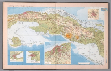
Full Title
Division politico - administrativa, 1968. Atlas nacional de Cuba : en el decimo aniversario de la Revolucion. La Habana 1970.
List No
13566.008
Note
Map of Cuba, shows political and administrative boundaries. Includes 2 insets: Division politico - administrativa, antes de 1959. Esquema Division politico - administrativa, 1969. Includes let of provinces and regions.
Author
[Instituto de Geografía (Academia de Ciencias de Cuba), Akademiia nauk SSSR. Institut geografii.]
Full Title
Cuba y los paises vecinos. Atlas nacional de Cuba : en el decimo aniversario de la Revolucion. La Habana 1970.
List No
13566.009
Note
Political map of Cuba and neighboring countries.
Author
[Instituto de Geografía (Academia de Ciencias de Cuba), Akademiia nauk SSSR. Institut geografii.]
Full Title
Provincia de Pinar del Rio. Atlas nacional de Cuba : en el decimo aniversario de la Revolucion. La Habana 1970.
List No
13566.010
Note
Map of Pinar del Rio Province, with 2 insets: plan of the city of Pinar del Rio and Location map.
Author
[Instituto de Geografía (Academia de Ciencias de Cuba), Akademiia nauk SSSR. Institut geografii.]
Full Title
Provincias de la Habana, de Matanza y de Las Villas. Atlas nacional de Cuba : en el decimo aniversario de la Revolucion. La Habana 1970.
List No
13566.011
Note
Map of the Havana, Matanza and Las Villas provinces. with 5 insets: City plans of Matanzas, Cienfuegos, La Habana, Santa Clara and Location map.
Author
[Instituto de Geografía (Academia de Ciencias de Cuba), Akademiia nauk SSSR. Institut geografii.]
Full Title
Provincias de Camaguey y de Oriente. Atlas nacional de Cuba : en el decimo aniversario de la Revolucion. La Habana 1970.
List No
13566.012
Note
Map of Camaguey and Oriente provinces. with 4 insets: City plans of Camaguey, Holguin, Santiago de Cuba and Location map.
Author
[Instituto de Geografía (Academia de Ciencias de Cuba), Akademiia nauk SSSR. Institut geografii.]
Full Title
Mapa Fisico. Atlas nacional de Cuba : en el decimo aniversario de la Revolucion. La Habana 1970.
List No
13566.013
Note
Physical and geological map of Cuba, with inset map: America Central y Las Antillas, and 2 profiles of Pico Turquino.
Author
[Instituto de Geografía (Academia de Ciencias de Cuba), Akademiia nauk SSSR. Institut geografii.]
Full Title
Geologia. Atlas nacional de Cuba : en el decimo aniversario de la Revolucion. La Habana 1970.
List No
13566.015
Note
Geological map of Cuba. With inset of 6 Geological cross sections. Includes color coded reference to geological formations.
Author
[Instituto de Geografía (Academia de Ciencias de Cuba), Akademiia nauk SSSR. Institut geografii.]
Full Title
Tectonica. Atlas nacional de Cuba : en el decimo aniversario de la Revolucion. La Habana 1970.
List No
13566.016
Note
Tectonic map of Cuba. With inset: Esquema de las estructuras tectonicas principales. Includes color coded reference to geological formations.
Author
[Instituto de Geografía (Academia de Ciencias de Cuba), Akademiia nauk SSSR. Institut geografii.]
Full Title
Sismicidad. Atlas nacional de Cuba : en el decimo aniversario de la Revolucion. La Habana 1970.
List No
13566.019
Note
Seismicity map of Cuba. With inset map: Declinacion magnetica. Includes color coded reference.
Author
[Instituto de Geografía (Academia de Ciencias de Cuba), Akademiia nauk SSSR. Institut geografii.]
Full Title
Temperatura media anual suma de temperaturas Medias diarias superiores A+10C. Temperaturas medias mensuales del aire. Atlas nacional de Cuba : en el decimo aniversario de la Revolucion. La Habana 1970.
List No
13566.030
Note
4 climate map of Cuba on 1 sheet. Shows average seasonal and daily air temperatures above +10 C. Includes 4 diagrams, showing variations of annual air temperatures.
Author
[Instituto de Geografía (Academia de Ciencias de Cuba), Akademiia nauk SSSR. Institut geografii.]
Full Title
Situacion sinoptica. Atlas nacional de Cuba : en el decimo aniversario de la Revolucion. La Habana 1970.
List No
13566.035
Note
2 maps on 1 page, showing extreme temperatures occur in Summer and Winter.
Author
[Instituto de Geografía (Academia de Ciencias de Cuba), Akademiia nauk SSSR. Institut geografii.]
Full Title
Temperatura de las aguas del mar. Atlas nacional de Cuba : en el decimo aniversario de la Revolucion. La Habana 1970.
List No
13566.054
Note
2 maps on 1 sheet. Shows sea water temperature. Includes inset map, and charts.
Author
[Instituto de Geografía (Academia de Ciencias de Cuba), Akademiia nauk SSSR. Institut geografii.]
Full Title
Exploraciones geograficas en Cuba, Siglos XV, XVI, XVII. Atlas nacional de Cuba : en el decimo aniversario de la Revolucion. La Habana 1970.
List No
13566.099
Note
Map of Cuba, Showing land and sea exploration routes in Cuba in 15-17 Centuries. Includes inset: Rutas maritimas entre Esnana y sus colonias Americanas.
Author
[Instituto de Geografía (Academia de Ciencias de Cuba), Akademiia nauk SSSR. Institut geografii.]
Full Title
Luchas armadas del pueblo Cubano por su independencia, 1868-1898. Sublevaciones armadas y Luchas en la Republica mediatzada, 1902-1952. Atlas nacional de Cuba : en el decimo aniversario de la Revolucion. La Habana 1970.
List No
13566.101
Note
2 maps on 1 sheet, with insets: Batalla de Santiago de Cuba, 188; La Habana. Maps showing armed uprising and struggles of the Cuban people for their independence.
Author
[Instituto de Geografía (Academia de Ciencias de Cuba), Akademiia nauk SSSR. Institut geografii.]
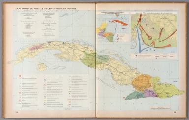
Full Title
Luchas armadas del pueblo Cuba por su liberacion, 1953-1958. Atlas nacional de Cuba : en el decimo aniversario de la Revolucion. La Habana 1970.
List No
13566.102
Note
Map of Cuba, with insets: Movimientos contrarrevolucionarios previos al ataque a playa Giron (1961); Derrota del ataque contrarrevolucionario en Playa Giron, (1961). Showing Armed struggles of the Cuban people for their liberation, the battle fields, the attack by land, sea and air and defeat of the counterrevolutionary attack in Playa Giron.
Author
Rand McNalley & Company
Full Title
Rand McNally road map : Florida.
List No
14003.018
Note
Road map of Florida, showing interstate and state highways, paved and dirt roads, and ferries, as well as state and national parks. Includes compass rose, time zones, and bar scale with scale statement: One inch equals approximately 21 miles. Features legend indicating population. With 2 insets: Cuba -- Florida (western section). Copyright by Rand McNally & Company, Chicago, Ill. Lithographed in the U.S.A.
Author
[Canet Alvarez, Gerardo A., 1911-, Raisz, Erwin, 1893-1968, Harvard University. Institute of Geographical Exploration, Cuba. Ministerio de Agricultura]
Full Title
Altas de Cuba por Gerardo Canet con la colaboración de Erwin Raisz.
List No
14350.002
Note
Frontispiece to Altas de Cuba. Includes a pictorial bird's-eye view of Cuba, as well as four views. Each of the latter accompanied by descriptive text, which appears in Spanish, with English translation. For example, first text begins: Las playas de la Isla tienen toda la gama del azul en sus aguas cristalinas, arena blanca y finísima ... = The Cuban beaches are made of fine white sand and the water in infinite shades of blue, is remarkably clear ...
Author
[Canet Alvarez, Gerardo A., 1911-, Raisz, Erwin, 1893-1968, Harvard University. Institute of Geographical Exploration, Cuba. Ministerio de Agricultura]
Full Title
Cuba, centro de las Americas -- El mundo alrededor de Cuba.
List No
14350.006
Note
Two maps showing Cuba's position, first within the Americas and, second, within the globe. Titles translate to: Cuba, center of the Americas -- The world around Cuba. First map shows cities, coastlines and the direction of ocean currents. Second map shows major international cities and concentric circles of distance from Cuba. Both maps include pictorial elements, bar scales and descriptive text, which appears in Spanish, with English translations.
Author
[Canet Alvarez, Gerardo A., 1911-, Raisz, Erwin, 1893-1968, Harvard University. Institute of Geographical Exploration, Cuba. Ministerio de Agricultura]
Full Title
Descubrimiento, conquista y colonización : Viajes de Colón -- Cuba, base para las conquistas -- Cuba en el siglo XVI -- La conquista -- La Habana, punto de reunión de las flotas.
List No
14350.007
Note
Five maps showing the history of Cuba in the sixteenth century. Titles translate to: Discovery, conquest and colonization : Voyages of Columbus -- Cuba, base for the conquests -- Cuba in the 16th century -- The conquest -- Havana, meeting point of the fleets. Maps show cities, coastlines, routes of explorers and mission locations. Maps include pictorial elements (such as indigenous artifacts) and descriptive text, which appears in Spanish, with English translations. Accompanied by a timeline on left, which spans the dates 1500 to 1600 and lists historical events.
Author
[Canet Alvarez, Gerardo A., 1911-, Raisz, Erwin, 1893-1968, Harvard University. Institute of Geographical Exploration, Cuba. Ministerio de Agricultura]
Full Title
Cuba colonial : Siglo XVII -- Cuba en el siglo XVIII.
List No
14350.008
Note
Two maps showing the history of Cuba in the seventeenth through nineteenth centuries. Titles translate to: Colonial Cuba : 17th century -- Cuba in the 18th century. With inset bird's-eye view, which shows the city of Havana, illustrating its topography, vegetation, roads, points of interest and coastline. Includes illustrations and descriptive text, which appears in Spanish, with English translations. Accompanied by a timeline on left, which spans the dates 1600 to 1825 and lists historical events.
Author
[Canet Alvarez, Gerardo A., 1911-, Raisz, Erwin, 1893-1968, Harvard University. Institute of Geographical Exploration, Cuba. Ministerio de Agricultura]
Full Title
Cuba insurrecta : Primeras luchas -- La guerra del '68 -- La guerra del '95.
List No
14350.009
Note
Three maps showing the history of Cuba in the nineteenth and twentieth centuries. Titles translate to: Insurrectionary Cuba : First struggles -- The war of '68 -- The war of '95. Maps show cities, coastlines and locations of military events. Maps include pictorial elements and descriptive text, which appears in Spanish, with English translations. Accompanied by a timeline on left, which spans the dates 1840 to 1940 and lists historical events. With illustrations, charts and diagram, which represents population.
Author
[Canet Alvarez, Gerardo A., 1911-, Raisz, Erwin, 1893-1968, Harvard University. Institute of Geographical Exploration, Cuba. Ministerio de Agricultura, Chamberlin, J. W.]
Full Title
Clima : Lluvia anual -- Lluvias mensuales según J. W. Chamberlin : Enero - Febrero - Marzo - Abril - Mayo - Junio - Julio - Agosto - Sepbre. - Octubre - Novbre. - Dicbre. -- Habana ....
List No
14350.010
Note
Maps showing the climate of Cuba. Titles translate to: Climate : Annual rain -- Monthly rainfall according to J. W. Chamberlin : January - February - March - April - May - June - July - August - September - October - November - December -- Havana ... . World map shows different climates in the Western Hemisphere. Maps of the island of Cuba show annual rainfall and rainfall in each month. In addition, a group of maps show cities, including of Havana. With inset map showing global wind patterns. Accompanied by descriptive text, which appears in Spanish, with English translations.
Author
[Canet Alvarez, Gerardo A., 1911-, Raisz, Erwin, 1893-1968, Harvard University. Institute of Geographical Exploration, Cuba. Ministerio de Agricultura]
Full Title
Ciclones : Distribución mundial de los ciclones ...
List No
14350.011
Note
Maps showing the occurrence of hurricanes in Cuba and the broader globe, as well as magnetism and gravity. Titles translate to: Cyclones : Global distribution of cyclones ... . Maps of the island of Cuba show the dates of historic hurricanes in different months. With chart: Frecuencia de los cilones [= Frequency of cyclones]. Accompanied by descriptive text, which appears in Spanish, with English translations.
Author
[Canet Alvarez, Gerardo A., 1911-, Raisz, Erwin, 1893-1968, Harvard University. Institute of Geographical Exploration, Cuba. Ministerio de Agricultura]
Full Title
Oceanografia.
List No
14350.012
Note
Maps showing ocean surrounding Cuba. Title translates to: Oceanography Features ocean depths and currents surrounding the country. With three cross section views showing the landscape beneath the ocean surface. Includes illustrations, charts of ocean temperature and an illustration depicting the cycle of life underwater. Accompanied by descriptive text, which appears in Spanish, with English translations.
Author
[Canet Alvarez, Gerardo A., 1911-, Raisz, Erwin, 1893-1968, Harvard University. Institute of Geographical Exploration, Cuba. Ministerio de Agricultura]
Full Title
Geologia.
List No
14350.013
Note
Maps showing the geology of Cuba. Title translates to: Geology Features distribution of geological characteristics in the country. With ten cross section views showing the geologic terrain beneath the landscape surface. Includes a legend and illustrations. Accompanied by descriptive text, which appears in Spanish, with English translations.
Author
[Canet Alvarez, Gerardo A., 1911-, Raisz, Erwin, 1893-1968, Harvard University. Institute of Geographical Exploration, Cuba. Ministerio de Agricultura]
Full Title
Geomorfologia.
List No
14350.014
Note
Maps showing the geomorphology of Cuba. Title translates to: Geomorphology Features distribution of geomorphology in the country, as well as topography and drainage. Relief shown pictorially. With eight cross section views showing the geomorphological terrain beneath the landscape surface. Accompanied by descriptive text, which appears in Spanish, with English translations.
Author
[Canet Alvarez, Gerardo A., 1911-, Raisz, Erwin, 1893-1968, Harvard University. Institute of Geographical Exploration, Cuba. Ministerio de Agricultura]
Full Title
Suelos.
List No
14350.015
Note
Maps showing the soil of Cuba. Title translates to: Soils Features distribution of soil types in the country. With six cross section views showing the soil layers beneath the landscape surface. Map indexed, with key at left. Includes a legend and illustrations. Accompanied by descriptive text, which appears in Spanish, with English translations.
Author
[Canet Alvarez, Gerardo A., 1911-, Raisz, Erwin, 1893-1968, Harvard University. Institute of Geographical Exploration, Cuba. Ministerio de Agricultura]
Full Title
Recursos forestales -- Pesca.
List No
14350.016
Note
Two maps showing the forests and fishing of Cuba. Titles translate to: Forest resources -- Fishing Features distribution of fishing locations in the country. With diagrams and illustrations. Accompanied by descriptive text, which appears in Spanish, with English translations.
Author
[Canet Alvarez, Gerardo A., 1911-, Raisz, Erwin, 1893-1968, Harvard University. Institute of Geographical Exploration, Cuba. Ministerio de Agricultura]
Full Title
Vegetacion.
List No
14350.017
Note
Map showing the vegetation of Cuba. Title translates to: Vegetation Features distribution of different vegetation types in the country. Includes a bar scale. With views of different vegetation types. Accompanied by descriptive text, which appears in Spanish, with English translations. (Page numbers inferred.)
Author
[Canet Alvarez, Gerardo A., 1911-, Raisz, Erwin, 1893-1968, Harvard University. Institute of Geographical Exploration, Cuba. Ministerio de Agricultura]
Full Title
Poblacion.
List No
14350.018
Note
Three maps showing the population of Cuba. Title translates to: Population Features distribution of population in the country. Includes a bar scale. With charts depicting population over time, from the nineteenth and into the twentieth century. Accompanied by descriptive text, which appears in Spanish, with English translations.
Author
[Canet Alvarez, Gerardo A., 1911-, Raisz, Erwin, 1893-1968, Harvard University. Institute of Geographical Exploration, Cuba. Ministerio de Agricultura]
Full Title
Patron de vida.
List No
14350.019
Note
Map showing the human geography of Cuba. Title translates to: Life patterns Features roads, railways, population and water consumption in the country. Includes a bar scale. With views comparing urban and rural communities. With charts depicting the economy, tracing changes in the twentieth century. Accompanied by descriptive text, which appears in Spanish, with English translations.
Author
[Canet Alvarez, Gerardo A., 1911-, Raisz, Erwin, 1893-1968, Harvard University. Institute of Geographical Exploration, Cuba. Ministerio de Agricultura]
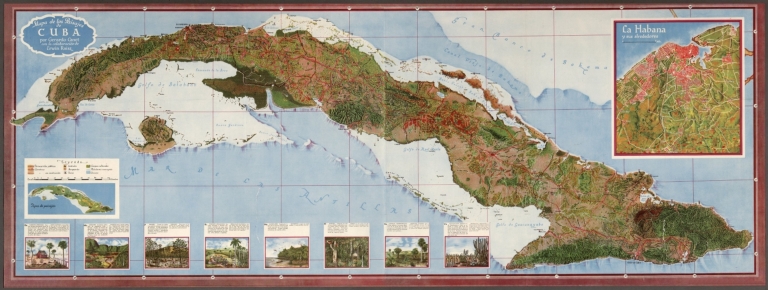
Full Title
Mapa de los Paisajes de Cuba por Gerardo Canet con la colaboración de Erwin Raisz.
List No
14350.037
Note
Map of Cuba. Shows cities, roads, railways, topography, vegetation, drainage, coastline, lighthouses, islands and ocean depths. Relief shown pictorially. Includes latitudinal and longitudinal lines, as well as a legend and bar scale. With two inset maps: Tipos de paisajes [= Types of landscapes] -- La Habana y sus alrededores [= Havana and its surroundings]. In addition, with views depicting various ecosystem types, accompanied by descriptive text, which appears in Spanish, with English translations. Map is 53 x 146 cm, on fold-out sheet 56 x 151 cm.
Author
[Valverde Alvarez, Emilio (1848-1894), Soler, A.]
Full Title
Atlas geografico descriptivo de la Peninsula Iberica, Islas Baleares, Canarias y posesiones Espanolas de Ultrama, por... D. Emilio Valverdo y Alvarez. Isla de Cuba. E. Valverde, dibujo. A. Soler, grabo. Imprenta y Litografía de la Biblioteca Universal. (at upper margin) Numero 57. (to accompany) Atlas geografico descriptivo de la Peninsula Iberica ... Ano 1880. 1a. Edicion.
List No
11468.064
Note
Color lithograph map on 2 sheets. Shows boundaries, capitals, major cities, towns, roads, rivers, port cites and landmarks. Includes legend, note and descriptive text. Relief shown by shadings.
|