|
Author
[Fisher, Joseph R., Planters Peanuts (Firm)]
Full Title
Minnesota : The gopher state -- Iowa : The hawkeye state -- Missouri : The show me state -- Kansas : The sunflower state.
List No
14374.011
Note
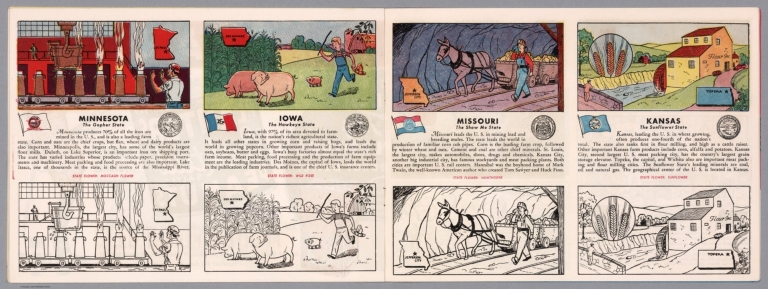
Four views, representing Minnesota, Iowa, Missouri and Kansas. Views show examples of the landscape and natural resources. Each view includes an inset map of the state, which marks the location of the capital city with a star. Accompanied by descriptive text, the state flags, seals and flowers: moccasin flower, wild rose, hawthorne and sunflower, respectively. The view of each state appears both in color (on top) and in black and white (bottom), the latter inviting coloration. Together, views are 18 x 52 cm, on two sheets 20 x 54 cm.
Author
Arbuckle Bros.
Full Title
Missouri, Oregon, Iowa, North Dakota. Copyright 1889 Arbuckle Bros. N.Y.
List No
0027.003
Note
Sheet with maps of four states in full color. Oregon is noted for its salmon fisheries, and the card features a fisherman as well as canned salmon. Little is written about North Dakota, but it is noted that "the temperature varies from 20 degrees below zero to 100 degrees Fahrenheit." Each card measures 7.5 x 12.5 cm.
Author
Asher & Adams
Full Title
Asher & Adams' Missouri. Entered according to Act of Congress in the year 1874 by Asher & Adams ... at Washington. (New York, 1874)
List No
0041.023
Note
Hand col. engraved map. Shows townships, distances along railroads, etc. Prime meridians: Greenwich and Washington.
Author
[Bartholomew, John, Black, Adam & Charles]
Full Title
Missouri and Arkansas. Published by A. & C. Black. Edinburgh. Printed in Colours by Schenck & Macfariane. Edinburgh. Drawn & Engraved by J. Bartholomew, Edinburgh.
List No
0073.013
Note
States outlined in color. Land tinted.
Author
Bradford, Thomas G.
Full Title
Missouri. Entered ... 1838, by T.G. Bradford ... Massachusetts. Engraved by G.W. Boynton.
List No
0089.036
Note
In full color.
Full Title
Carte geographique, statistique et historique du Missouri. Missouri. Grave par B. de Beaupre, Rue de Vaugirard, No. 81, a Paris. Fonderie et Imprimerie de J. Carez. (1825)
List No
0102.034
Note
Hand colored engraved map. Relief shown by hachures. Text and tables at sides and bottom. Prime meridians: Washington and Paris.
Author
Burr, David H., 1803-1875
Full Title
Map of Illinois & Missouri Exhibiting the Post Offices, Post Roads, Canals, Rail Roads, &c. By David H. Burr. (Late Topographer to the Post Office.) Geographer to the House of Representatives of the U.S. John Arrowsmith. Entered ... July 10th, 1839, by David H. Burr ... District of Columbia.
List No
0104.012
Note
In full color by county. Postal routes by coach, stage, sulkey, cross, rail roads and canals shown. In 8 sections mounted on linen. Label on back states "No. 12. Illinois, Missouri."
Author
[Carey, H. C., Lea, I.]
Full Title
Geographical, Historical, And Statistical Map Of Missouri. Missouri. No. 34. Engraved by Young & Delleker.
List No
0122.029
Note
In full color by county or region surrounded by text.
Author
[Carey, H. C., Lea, I.]
Full Title
Geographical, Historical, And Statistical Map Of Arkansas Territory. Map Of Arkansas And Other Territories of the United States Respectfully inscribed to the Hon. J.C. Calhoun Secretary Of War By S.H. Long Major T. Engineers. No. 35. Drawn by S.H. Long Maj. U.S. Engineers. Engraved by Young & Delleker.
List No
0122.030
Note
In full color by region surrounded by text.
Author
Finley, Anthony
Full Title
Map of the State of Missouri And Territory of Arkansas Compiled From The Latest Authorities. Drawn by D.H. Vance. Engraved by J.H. Young. Published by A. Finley Philadelphia 1826.
List No
0278.012
Note
In full color by county or region. Statistical table breaks down population from the 1820 census by white, blacks, and foreigners not naturalized. Square mileage also noted.
Author
Finley, Anthony
Full Title
Map of the State of Missouri and the Territory of Arkansas, Compiled from the Latest Authorities.
List No
0279.016
Note
Date estimated.
Author
Finley, Anthony
Full Title
Map of the States of Missouri and Territory of Arkansas, Compiled from the Latest Authorities. Drawn by D.H. Vance. Published by A. Finley, Philadelphia. Engraved by J.H. Young.
List No
0280.012
Note
Relief shown by hachures. Prime meridian Washington. Statistical table for each state.
Author
[Colton, G.W., Colton, C.B., Gray, O.W.]
Full Title
Missouri. Entered ... 1869 by G.W. & C.B. Colton & Co.
List No
0312.045
Author
U.S. General Land Office
Full Title
State of Missouri. Department of the Interior, General Land Office, October 2nd 1866. Jo. S. Wilson, Commissioner. No. 9. Bowen & Co. Lith. Phila.
List No
1070.009
Note
In outline color. Topographical information is included in the note area.
Author
Rand McNalley & Company
Full Title
Rand McNally road map : Missouri.
List No
14003.029
Note
Road map of Missouri, showing interstate and state highways, paved and dirt roads, and ferries, as well as state and national parks. Includes compass rose, time zones, and bar scale with scale statement: One inch equals approximately 21 miles. Features legend indicating population. Copyright by Rand McNally & Company, Chicago, Ill. Lithographed in the U.S.A.
Author
[Bates, Ernest Sutherland, 1879-1939, Schiff, Herman S., Reeves, Norman, Smith, Robert E.]
Full Title
Missouri, 1821.
List No
14244.057
Note
Pictorial map of Missouri, showing political boundaries with bordering states and major rivers. Features natural resources and manufactured items (including zinc, potatoes, game and corn cob pipes). Includes a compass rose and a scroll listing notable places - such as Mark Twain Birthplace - which are pictured in vignettes to the right of map, in order of listing. Map is 22 x 24 cm, on sheet 23 x 29 cm. Accompanied by historical text on facing page.
Author
Bradstreet Company
Full Title
Missouri. (to accompany) Bradstreet's Pocket Atlas Of The United States. Published Exclusively for Macullar, Parker & Company, Boston, Massachusetts ... New York: The Bradstreet Company, 1885. (on verso) Entered ... 1879, by The Bradstreet Company ... Washington.
List No
2054.043
Note
Full color map. Showing Indian Territory. Relief shown by hachures. Prime meridian is Washington, D.C.
Author
Rand McNally and Company
Full Title
Rand, McNally & Co.'s Missouri.
List No
2094.039
Note
Counties outlined in color. Meridians Washington and Greenwich. Railroads highlighted. Relief shown by hachures.
Author
[Breese, Samuel, 1802-1873, Morse, Sidney E. (Sidney Edwards), 1794-1871]
Full Title
Missouri. Entered ... 1844 by Sidney E. Morse and Samuel Breese ... New York. (New York: Published by Harper & Brothers, 1845)
List No
2301.023
Note
Col. wax engraved map. Relief shown by hachures. Prime meridians: Greenwich and Washington.
Author
Lange, Henry, 1821-1893.
Full Title
Iowa, Missouri u. Illinois. H. Lange's Atlas v. Nord Amerika Blatt VIII. Braunschweig: Verlag v. George Westermann. Lith. Anst. von L. Kraatz in Berlin.
List No
2743.008
Note
Engraved map. Borders hand col. Shows roads, railroads, canals, etc. Relief shown by hachures.
Author
Tanner, Henry S.
Full Title
Illinois And Missouri. (engraved by) J. Knight. Sc. (inset) Missouri River, West Part. (to accompany) A New Pocket Atlas of the United States With The Roads and Distances, Designed For the Use of Travelers. By H.S. Tanner. Philadelphia: Published by the Author. 1828. (on verso) ...on the seventeenth day of November ... 1828, Henry S. Tanner ... hath deposited ... a book ... Pennsylvania.
List No
2782.014
Note
Outline colored map. Prime meridian is Washington, D.C. Rare. Same maps used in Darby's View of U.S. Although this appears in Tanner's catalogues for several years after 1828, it must not have sold well, as few copies have survived. Bound with half leather and paper covered boards. "Pocket Atlas" embossed on spine.
Author
Rand McNally and Company
Full Title
Rand, McNally & Co.'s Missouri.
List No
2844.057
Note
Tables of railroads and chief cities keyed to map. Inset shows extension of state.
Author
Smith, J. Calvin
Full Title
(Nebraska, Kansas, Iowa, Missouri).
List No
3471.005
Note
Estimated Date. Part of a sixteen piece map combined digitally as a composite in final map of series.
Author
[Johnston, Alexander Keith, 1804-1871, Rogers, Henry Darwin]
Full Title
States Of Illinois, Missouri, And Arkansas. By Prof. H.D. Rogers & A. Keith Johnston, F.R.S.E. Entered in Sta. Hall. London ... & according to an act of Congress ... 1857, by H.D. Rogers ... Massachusetts. London, John Murray, Albemarle Street, Edinburgh, W. & A.K. Johnston. Engraved by W. & A.K. Johnston, Edinburgh.
List No
3825.012
Note
States in printed outline color with counties in blue.
Author
Mitchell, Samuel Augustus
Full Title
Map of the State of Missouri And Territory Of Arkansas Compiled From The Latest Authorities. Published by S. Augustus Mitchell Philadelphia. 1831. J.H. Young Sc.
List No
3884.012
Note
Full color by county or territory.
Author
National Map Company
Full Title
Missouri. (Copyrighted by) National Map Company, Indianapolis. (to accompany) Official Paved Road and Commercial Survey of the United States. (with insets). Vicinity of St. Louis ; Continuation of map.
List No
4048.042
Note
Outline color map. Inset showing continuation of southeast portion of map. Shows administrative divisions, roads, rivers, etc. Prime meridian is Greenwich.
Author
[Morse, Sidney E. (Sidney Edwards), 1794-1871, Breese, S.]
Full Title
Missouri. (to accompany) Supplement To The New-York Observer. The Cerographic Atlas Of The United States. No.3. 1845. Entered ... 1845, by Sidney E. Morse and Samuel Breese ... New-York.
List No
4180.025
Note
Uncolored map. Shows state capital, county, towns, roads, railroads, rivers, canals, etc. Relief shown by hachures. Prime meridians are Greenwich and Washington. Includes explanation.
Author
Rand McNally and Company
Full Title
Rand McNally Junior Auto Road Map of Missouri. Copyright by Rand McNally & Company. Chicago, Ill. Made in U.S.A. P.1091.
List No
4245.026
Note
Color map. Includes explanation, showing roads, rivers, ferries and boatlines, points of interest. Includes alphabetical index giving towns, populations of towns and Key to map. U.S. interstate highways shown in red. Shows Highway markers.
Author
State Farm Insurance Companies Travel Bureau
Full Title
State Farm Road map: Missouri. Copyright by Rand McNally & Company, Chicago, Ill. Lithographed in U.S.A. Z.3606. (on upper corners) Missouri. (inset) Southeastern Missouri.
List No
4246.030
Note
Color map with inset. Shows roads, points of interest, distances, ferries and boatlines, time zone boundaries, populations, etc. U.S. interstate and principal state highways shown in red.
Author
Hillebrands, A.J.
Full Title
Atlas de Vereenigde Staten No. 9. Iowa, Illinois, Nebraska, Missouri, Western Territory en Arkansas.
List No
4323.011
Note
A scarce small atlas of ten maps published in Holland, but authored by a school teacher from the Dutch Colony in Holland, Michigan. It was most likely sold to Dutch Americans and those in Holland planning to emigrate or who had relatives in America. The date is estimated by Phillips and Koeman. Koeman lists an earlier edition of 1849, with five maps. There is a double page of text at the end of the maps, with lists of distances by steamboat and railroad. The copy listed in Phillips has a cover title, not present here. Maps are hand painted with outline color.
Author
Clason Map Company
Full Title
Clason's Road Map of Missouri. Showing paved roads, All weather roads and other throughfares. (U.S. Highways shown in red.) Published by the Clason Map Co., Denver. Copyrighted Clason Map. All rights reserved. Map No. R-210A.
List No
4423.031
Note
Color map. Includes road legend, and Index of cities and towns giving 1930 Census populations and Key to map.
Author
Rand McNally and Company
Full Title
Rand, McNally & Co.'s Missouri and Arkansas.
List No
4520.028
Note
In outline color by county. Shows named railroads. Prime meridians: Greenwich and Washington.
Author
Cram, George Franklin
Full Title
Cram's Rail Road & Township Map of Missouri.
List No
4533.006
Author
[Collot, George Henri Victor, Tardieu, P.F.]
Full Title
Plan of Cape Girardo. Grave par Tardieu l'aine. PL. 26.
List No
4664.016
Note
Plan of an early Missouri town on the Mississippi. Uncolored with scale in Fathoms.
Author
[Collot, George Henri Victor, Tardieu, P.F.]
Full Title
Plan of St. Lewis With the Project of an intrenched Camp French. Grave par Tardieu l'aine. PL. 27.
List No
4664.017
Note
One of the earliest maps of St. Louis, before the Louisiana Purchase in 1803. Uncolored with scale in Fathoms. Map is numbered and lettered but has no accompanying key.
Author
[Collot, George Henri Victor, Tardieu, P.F.]
Full Title
Map of the Country Of The Illinois. PL. 28.
List No
4664.018
Note
A superbly detailed map of the Mississippi River from the junction with the Illinois to the junction with the Kaskaskias River, especially good in the area around St. Louis. Uncolored.
Author
[Collot, George Henri Victor, Tardieu, P.F.]
Full Title
Plan of the Fort of New Madrid or Anse A La Graisse. Grave par Tardieu l'aine. PL. 30.
List No
4664.020
Note
Very early map of New Madrid seven years after the town's founding. It shows the erosion of the fort caused by the Mississippi. Illustrated in Reps "The Making of Urban America," fig. 284. Uncolored with scale in fathoms.
Author
[Morse, Sidney E. (Sidney Edwards), 1794-1871, Breese, Samuel]
Full Title
Missouri. Entered ... 1844 by Sidney E. Morse and Samuel Breese ... New York. (New York: Published by Harper & Brothers, 1845). (to accompany) Morse's Cerographic Maps. No. II.
List No
4861.016
Note
Color wax engraved map. Shows state capital, towns, road, railroads, canals, etc. Includes explanation. prime meridians are Washington and Greenwich. Relief shown by hachures.
Full Title
Illinois and Missouri. N. & S.S. Jocelyn Sc. (New-Haven: N. & S.S. Jocelyn. 1823)
List No
4869.011
Note
Engraved map with facing index page. Outline hand color. Relief shown by hachures. Prime meridians: Washington and Greenwich.
Author
[Hinton, Isaac Taylor, 1799-1847, Simpkin & Marshall]
Full Title
Map of the states of Missouri and Illinois. London, published ... 1832, by I.T. Hinton & Simpkin & Marshall. Engraved & printed by Fenner Sears & Co. (1832)
List No
4966.015
Note
Hand col. engraved map. Relief shown by hachures. Covers Illinois south of 41 degrees N. Prime meridians: Washington and Greenwich.
Author
Asher & Adams
Full Title
Asher & Adams' Missouri. Entered according to Act of Congress 1875 by Asher & Adams in the Office of the Librarian of Congress at Washington.
List No
4977.046
Note
Washington Meridian. Hand tinted full color. Shows railroads, settlements, counties, waterways, and lakes. Engraved.
Author
Rand McNally and Company
Full Title
Commercial Atlas of America. Rand McNally AutoTrails Map, District Number 1. Illinois, Western Indiana, S.E. Iowa, N.E. Missouri.
List No
5028.088
Note
Shows roads and distances. Shows table of highway names, numbers, and markings.
Author
Rand McNally and Company
Full Title
Commercial Atlas of America. Rand McNally AutoTrails Map, District Number 10, Iowa, E.Nebraska, S. Minnesota, N. Missouri, N.E. Kansas, W. Illinois.
List No
5028.104
Note
Shows roads and distances. Shows table of highway names, numbers, and markings.
Author
Rand McNally and Company
Full Title
Commercial Atlas of America. Rand McNally Standard Map of Missouri.
List No
5028.111
Note
Shows railroads and distances. Includes tables of principal cities and railroads, keyed to map.
Author
Rand McNally and Company
Full Title
Commercial Atlas of America. Rand McNally AutoTrails Map, District Number 19, (Missouri, Arkansas, Kentucky, Tennessee).
List No
5028.112
Note
Shows roads and distances. Shows table of highway names, numbers, and markings. Relief shown by hachures.
Author
Rand McNally and Company
Full Title
Commercial Atlas of America. Rand McNally Black and White Mileage Map, Missouri.
List No
5028.113
Note
Shows railroads and distances.
Author
Mitchell, Samuel Augustus Jr.
Full Title
County and Township Map of the States of Iowa and Missouri. Entered ... 1874 by S. Augustus Mitchell ... Washington.
List No
5041.028
Note
Prime meridians are Washington D.C. and Greenwich.
Author
Schonberg & Co.
Full Title
Schonberg's Map of Missouri. Entered ... 1866 ... New York.
List No
5198.029
Note
Counties shown in color. Prime meridians Washington D.C. and Greenwich. Relief shown by hachures.
Author
Cram, George Franklin
Full Title
Cram's Rail Road & Township Map of Missouri. Published by Geo. F. Cram. Proprietor of the Western Map Depot. 66, Lake St. Chicago Ills. 1875.
List No
5370.014
Note
Map in full color by county. The railroad lines are clearly marked. (Note: The map has been rotated 90 degrees clockwise for readability.)
Author
Colton, G.W.
Full Title
The City of St. Louis, Missouri. The City of Chicago, Illinois. No. 45. Published by J.H. Colton & Co., No 172 William St., New York. Entered according to the Act of Congress in the year 1855 by J.H. Colton & Co. in the Clerk's Office of the District Court of the United States for the Southern District of New York.
List No
5479.089
Note
Two city street maps on one sheet. Neighborhoods tinted in color.
|