|
Full Title
(Composite of) Carte de France (Cassini Projection). Levee par ordre du Roy. (1750-1815)
List No
5694.202
Note
Cassini Soldare projection is used, the original projection with the prime meridian at Paris Observatory. Composite of 182 engraved maps. Relief shown by hachures.
Full Title
(Composite of) Carte de France. Levee par ordre du Roy. (1750-1815)
List No
5694.201
Note
Composite of 182 engraved maps. Relief shown by hachures.
Author
[Paullin, Charles O., Wright, John K.]
Full Title
Plate 23. Delisle Map, 1703. Delisle Map 1750. Bellin Map, 1743. (Facsimiles).
List No
0702.026
Author
de Vaugondy, Robert
Full Title
(Facsimile) Robert de Vaugondy - 1750. S. Doc 91 55 2. 31. Part of a Map of South America by Robert de Vaugondy, Paris, 1750. Reproduced from Original (in his Atlas Universel, Paris, 1757, Pl. 101,) in Library of Congress, Washington, D.C. Lith. by A. Hoen & Co., Baltimore, MD.
List No
1122.036
Author
Van's Gravesande, Storm
Full Title
Storm Van's Gravesande - 1750. S 91 55 2. 60. Map of the Orinico - Essequibo Region, Handed to the West India Company by Governor Storm Van's Gravesande, June 22, 1750. Reproduced fromm the Manuscript Copy on Parchment in the Rijksarchief at te Hague, No. 1496 of the Catalogue. Photo. Lith. by A. Hoen & Co., Baltimore, MD.
List No
1122.066
Full Title
(Covers to) (Carte de France. Levee par ordre du Roy. 1750-1815)
List No
5694A
Author
Capitaine, Louis, ca. 1749-ca. 1797
Full Title
Tableau de la carte generale de la France. Pour servir a l'assemblage de 24 feuilles de la carte reduite sur l'Echelle d'une ligne pour 400 toises, et de celle en 180 feuilles. Le Depot des Cartes est a l'Observatoire ..., Ches L. Capitaine, Associe et Pr. Ingenieur de la Carte generale de la France. A Paris. (1797?)
List No
5694B
Note
Index to the 182 sheets and to reduced 24-sheet map. Engraved. Legend at bottom. David Rumsey collection with stamps: " ... An 8." and "Depot Gl. de la Guenne."
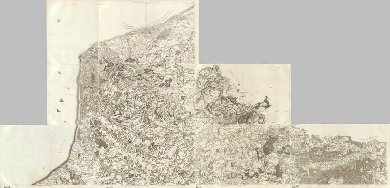
Full Title
(Composite of) Carte de France (1). No. 4 (Abbeville). No. 5 (Saint-Omer). No. 6 (Dunkerque). No. 21 (Ambleteuse - Calais - Pas-de-Calais). No. 22 (Boulogne). No. 23 (Dieppe). No. 41 (Lille). No. 42 (Cambrai). No. 78 (Mezieres). Levee par ordre du Roy. (1750-1815)
List No
5694.001
Note
Composite of 9 engraved maps. Sheets 4-6, 21-23, 41-42 and 77. Sheets 22-23 dated 1758. Engraver on sheet 22 Le Roy le Jeune. Relief shown by hachures. Covers Artois, Flandres and part of Picardie.
Full Title
(Composite of) (Carte de France. 2) No. 109 (Montmedy - Longwy - Bouillon. Levee par ordre du Roy. 1750-1815)
List No
5694.002
Note
One engraved map (sheet 109+). Relief shown by hachures. Covers St. Hubert region, Belgium.
Full Title
(Composite of) (Carte de France. 3). No. 170 (Saint-Pol-de-Leon). No. 171 (Carhaix - Brest). No. 173 (Philipsbourg. 1763). No. 173 (175. Audierne - rade de Brest. Levee par ordre du Roy. 1750-1815)
List No
5694.003
Note
Composite of 4 engraved maps. Relief shown by hachures. Sheets 170-171, 173 (flle. 174)-174. Sheets 170-171 engraved by Aldring. Covers portion of Bretagne. Sheet 173 shown as 175 on index map.
Full Title
(Composite of) (Carte de France. 4). No. 60 (Le Havre). No. 61 (Lisieux - Honfleur). No. 62 (Argentan - Falaise). No. 63 (Alencon. 1763). No. 93 (La Hougue). No. 94 (Bayeux - Caen). No. 95 (Vire - Avranches). No. 96 (Mayenne). No. 125 (Cherbourg). No. 126 (Coutances). No. 127 (Saint-Malo - Granville). No. 128 (Dinan). No. 131 (Nantes). No. 132 (La Roche-sur-Yon - Les Sables-d'Olonne). No. 133 (Ile de Re). No. 134 (Ile d'Oleron. Levee par ordre du Roy. 1750-1815)
List No
5694.004
Note
Composite of 14 engraved maps. Relief shown by hachures. Sheets 60-63, 93-96, 125-128, 156-157. Sheet 60 and 126 dated 1757; 93 dated 1758. Sheet 93: J. Seguin ... sculpsit ... Le Roy Laine, scripsit. Covers parts of Bretagne, Maine and Normandie.
Full Title
(Composite of) Carte de France. 5). No. 1 (Paris). No. 2 (Beauvais). No. 3 (Amiens). No. 7 (Fontainebleau - Etampes). No. 24 (Forges - Neufchatel). No. 25 (Rouen). No. 26 (Evreux - Dreux). No. 27 (Chartres). No. 43 (Laon - Noyon). No. 44 (Soissons). No. 45 (Meaux). No. 46 (Sens). No. 78 (Mezieres). No. 79 (Reims). No. 80 (Chalons-en-Champagne). No. 81 (Troyes. Levee par ordre du Roy. 1750-1815)
List No
5694.005
Note
Composite of 16 engraved maps. Relief shown by hachures. Sheets 1-3, 7, 24-27, 43-46, 78-81. Some sheets dated 1756-1759. Some sheets have engravers' and delineators' names: Bourgoin (le Jeune); R. Brunet; Desbruslins, Pere; Chalmandrier; LeRoy le Jeune. Covers parts of Champagne, I'le de France, Normandie and Picardie.
Full Title
(Composite of) (Carte de France. 6). No. 109 (Montmedy - Longwy - Bouillon). No. 110 (Verdun). No. 111 (Toul). No. 112 (Joinville). No. 141 (Metz). No. 141+ (Luxembourg). No. 142 (Nancy). No. 143 (Mirecourt - Epinal). No. 161 (Landau - Wissembourg). No. 162 (Strasbourg). No. 163 (Colmar). No. 173 (Philipsbourg. Levee par ordre du Roy. 1750-1815)
List No
5694.006
Note
Composite of 12 engraved maps. Relief shown by hachures. Sheets 109-112, 141+, 141-143, 161-163, 173. Some sheets dated 1759-1760. Some sheets have engravers' and delineators' names: J. Seguin, B. Desfontaines. Covers parts of Alsace, Louvaine and Luxembourg.
Full Title
(Composite of) (Carte de France. 7). No. 172 (Diocese de Quimper, Bretagne. Levee par ordre du Roy. 1750-1815)
List No
5694.007
Note
Engraved map. Relief shown by hachures. No. 172 (Diocese de Quimper, Bretagne).
Full Title
(Composite of) (Carte de France. 8). No. 64 (Le Mans). No. 65 (Tours). No. 66 (Richelieu - Saumur). No. 67 (Poitiers). No. 97 (Laval). No. 98 (Angers). No. 99 (Mortagne). No. 100 (Lucon). No. 129 (Rennes). No. 130 (Paimboeuf - Redon). No. 131 (Nantes). No. 132 (La Roche-sur-Yon - Les Sables-d'Olonne). No. 158 (Vannes). No. 159 (Belle-Isle) Levee par ordre du Roy. 1750-1815)
List No
5694.008
Note
Composite of 14 maps. Relief shown by hachures. Sheets 64-67, 97-100, 129-132, 158-159. One sheet dated 1765; some sheets engraved by Chalmandrier and Aldring. Covers parts of Anjou, Bretagne, Maine, Poitou and Touraine. Sheet 160 shown on index map never published.
Full Title
(Composite of) (Carte de France. 9). No. 8 (Orleans). No. 9 (Gien). No. 10 (Bourges). No. 11 (La Chatre). No. 28 (Vendome). No. 29 (Blois). No. 30 (Loches). No. 31 (Le Blanc - Chateauroux - Montmorillon). No. 47 (Auxerre). No. 48 (Vezelay - Cosne). No. 49 (Nevers). No. 50 (Moulins). No. 82 (Tonnerre). No. 83 (Semur - Montbard). No. 84 (Autun). No. 85 (Chalon-sur-Saone. Levee par ordre du Roy. 1750-1815)
List No
5694.009
Note
Composite of 16 maps. Relief shown by hachures. Sheets 8-11, 28-31, 47-50, 82-85. Most sheets undated; some dated 1758-1782; some sheets have named engravers or delineators: Aubin, R. Brunet, Bourgoin, M. Capitaine, Le Roy le Je., J. Seguin. Covers parts of Berri, Bourgogne, Bourbonnois, Nivernois, Orleanois and Touraine.
Full Title
(Composite of) (Carte de France. 10). No. 113 (Langres). No. 114 (Dijon). No. 115 (Dole - Auxonne). No. 116 (Tournus - Lons-le-Saunier). No. 144 (Luxeuil). No. 145 (Vesoul). No. 146 (Besancon). No. 147 (Nozeroy - Les Rousses). No. 164 (Neuf-Brisach). No. 165 (Bale. Levee par ordre du Roy. 1750-1815)
List No
5694.010
Note
Composite of 10 maps. Relief shown by hachures. Sheets 113-116, 144-147, 164-165. Sheets are undated. Some sheets have named engravers or delineators: J.A. Aveline, Chalmandrier, Durand and Le Roy le Jeune. Covers parts of Alsace, Bourgogne and Franche Comte.
Full Title
(Composite of) (Carte de France. 11). No. 68 (Charroux). No. 69 (Angouleme). No. 70 (Perigueux). No. 71 (Bergerac). No. 101 (La Rochelle). No. 102 (Saintes). No. 103 (Blaye). No. 104 (Bordeaux). No. 133 (Ile de Re). No. 134 (Ile d'Oleron). No. 135 (Cote de Medoc). No. 136 (La Teste de Buch. Levee par ordre du Roy. 1750-1815)
List No
5694.011
Note
Composite of 12 maps. Relief shown by hachures. Sheets 68-71, 101-104, 133-136. Sheets are undated. Some sheets have named engraver: Aldring. Covers parts of Guienne, Poitou and Saintonge.
Full Title
(Composite of) (Carte de France. 12). No. 12 (Evaux). No. 13 (Aubusson). No. 14 (Mauriac). No. 15 (Aurillac). No. 32 (Le Dorat). No. 33 (Limoges). No. 34 (Tulle - Pompadour). No. 35 (Sarlat). No. 51 (Gannat - Saint-Pourcain). No. 52 (Clermont). No. 53 (Brioude - Issoire). No. 54 (Saint-Flour). No. 86 (Macon). No. 87 (Lyon). No. 88 (Saint-Etienne - Saint-Marcellin). No. 89 (Le Puy. Levee par ordre du Roy. 1750-1815)
List No
5694.012
Note
Composite of 16 maps. Relief shown by hachures. Sheets 12-15, 32-35, 51-54, 86-89. Sheets are undated. Some sheets have named engravers and delineators: Aldring, Chalmandrier, Chambon. Covers parts of Auvergne, Bourbonnois, Limousin, Lyonnois and Marche.
Full Title
(Composite of) (Carte de France. 13). No. 117 (Bourg-en-Bresse). No. 118 (Belley). No. 119 (Grenoble). No. 120 (Valence). No. 148 (Geneve - Gex). No. 149 (Montmelian). No. 150 (Fort Barraux). No. 151 (Briancon). No. 166 (Queyras . Levee par ordre du Roy. 1750-1815)
List No
5694.013
Note
Composite of 9 maps. Relief shown by hachures. Sheets 117-120, 148-151, 166. Sheets are undated. Some sheets have named engravers and delineators: Aldring, C. Beauvais, Bourgoin, and R. Brunet. Covers parts of Bresse and Dauphine.
Full Title
(Composite of) (Carte de France. 14). No. 72 (Castillonez - Villeneuve - La Reole). No. 73 (Agen). No. 74 (Auch). No. 75 (Tarbes). No. 105 (Bazas). No. 106 (Roquefort - Mont-de-Marsan). No. 107 (Aire - Orthez). No. 108 (Pau - Bearn). No. 137 (Cazau). No. 138 (Vieux-Boucau). No. 139 (Bayonne). No. 140 (Saint-Jean-Pied-de-Port. Levee par ordre du Roy. 1750-1815)
List No
5694.014
Note
Composite of 12 maps. Relief shown by hachures. Sheets 72-75, 105-108, 137-140. Sheets are undated. Some sheets have named engravers and delineators: Aldring and Bourgoin. Covers parts of Bearn, Castillonez and Gascogne.
Full Title
(Composite of) (Carte de France. 15). No. 16 (Rodez). No. 17 (Albi). No. 18 (Castres). No. 19 (Carcassonne). No. 36 (Cahors). No. 37 (Montauban). No. 38 (Toulouse). No. 39 (Saint-Lizier - Saint-Martory - Pamiers). No. 55 (Mende). No. 56 (Nant - Millaud). No. 57 (Lodeve). No. 58 (Narbonne). No. 90 (Viviers). No. 91 (Nimes). No. 92 (Montpellier. Levee par ordre du Roy. 1750-1815)
List No
5694.015
Note
Composite of 15 maps. Relief shown by hachures. Sheets 16-19, 36-39, 55-58, 90-92. Sheets are undated. Some sheets have named engravers and delineators: Aldring, Bourgoin, Dupain. Covers parts of Gascogne, Languedoc, Querci and Roueregue.
Full Title
(Composite of) (Carte de France. 16). No. 121 (Vaison). No. 122 (Avignon - Orange). No. 123 (Aix). No. 124 (Marseille). No. 152 (Embrun). No. 153 (Digne). No. 154 (Lorgues). No. 155 (Toulon). No. 167 (Larche). No. 168 (Vence). No. 169 (Antibes). No. 182 (169+ Tour de Camarat. Levee par ordre du Roy. 1750-1815)
List No
5694.016
Note
Composite of 12 maps. Relief shown by hachures. Sheets 121-124, 152-155, 167-169, 182 (or 169+). Sheet 169+ is numbered 182. Sheets are undated. Some sheets have named engraver: Aldring Covers parts of Dauphine, Languedoc and Provence.
Full Title
(Composite of) (Carte de France. 17). No. 76 (Luchon - Bareges - Bagneres). No. 108+ (Cauterets. Levee par ordre du Roy. 1750-1815)
List No
5694.017
Note
Composite of 2 maps. Relief shown by hachures. Sheets 76 and 108+. Sheets are undated. Covers parts of Bearne and Gascogne.
Full Title
(Composite of) (Carte de France. 18). No. 20 (Montlouis - Mousset - Moussette). No. 20+ (Puigcerda - Prats de Mollo - Fort des Bains). No. 40 (Ax). No. 40+ (Andorre). No. 59 (Perpignan). No. 59+ (Bellegarde. Levee par ordre du Roy. 1750-1815)
List No
5694.018
Note
Composite of 6 maps. Relief shown by hachures. Sheets 20, 20+, 40, 40+, 59 and 59+ (labeled 56+ on index map). Sheets are undated. Some sheets have name of engraver or draftsman: Aldring, Dupain. Covers parts of Gascogne and Languedoc.
Full Title
Carte de France levee par ordre du Roy. No. 1 (Paris). Ecrit par Bougoin. 1736 (i.e. 1756, corr. 1761-1762)
List No
5694.019
Note
Engraved topographic map. Premiere feuille. Relief shown by hachures.
Full Title
Carte de France levee par ordre du Roy. No. 2 (Beauvais). 1756.
List No
5694.020
Note
Engraved topographic map. Fe. 2e. Relief shown by hachures.
Full Title
(Carte de France levee par ordre du Roy). No. 3 (Amiens. 1757)
List No
5694.021
Note
Engraved topographic map. Fe. 11e. Relief shown by hachures.
Full Title
(Carte de France levee par ordre du Roy). No. 4 (Abbeville. 1757)
List No
5694.022
Note
Engraved topographic map. Fe. 12e. Relief shown by hachures.
Full Title
(Carte de France levee par ordre du Roy). No. 5 (Saint-Omer). 1758.
List No
5694.023
Note
Engraved topographic map. Fe. 19e. Relief shown by hachures.
Full Title
Carte de France levee par ordre du Roy. No. 6 (Dunkerque. 1758). Feuille septentrionale.
List No
5694.024
Note
Engraved topographic map. 14e. Fe. Relief shown by hachures.
Full Title
(Carte de France levee par ordre du Roy). No. 7 (Fontainebleau - Etampes. 1758).
List No
5694.025
Note
Engraved topographic map. Fe. 3e. Relief shown by hachures.
Full Title
(Carte de France levee par ordre du Roy). No. 8 (Orleans. 1782)
List No
5694.026
Note
Engraved topographic map. Fe. 10e. "Le figure du terrein retouche avec des caracteres mobiles, imagines par M. Capitaine a l'Observatoire Royal, 1782." Relief shown by hachures.
Full Title
(Carte de France levee par ordre du Roy). No. 9 (Gien). Ecrit par le Roy le Je. (1759)
List No
5694.027
Note
Engraved topographic map. Fe. 14e. Relief shown by hachures.
Full Title
(Carte de France levee par ordre du Roy). No. 10 (Bourges). ... Grave ... par le Roy le Je. (1761)
List No
5694.028
Note
Engraved topographic map. Fe. 48e. Relief shown by hachures.
Full Title
(Carte de France levee par ordre du Roy). No. 11 (La Chatre. 1768)
List No
5694.029
Note
Engraved topographic map. Fle. 83e. Relief shown by hachures.
Full Title
(Carte de France levee par ordre du Roy). No. 12 (Evaux. 1762)
List No
5694.030
Note
Engraved topographic map. Flle. 56. Relief shown by hachures.
Full Title
(Carte de France levee par ordre du Roy). No. 13 (Aubusson. 1763)
List No
5694.031
Note
Engraved topographic map. Fle. 66. Relief shown by hachures.
Full Title
(Carte de France levee par ordre du Roy). No. 14 (Mauriac. 1780)
List No
5694.032
Note
Engraved topographic map. Fle. 158. Relief shown by hachures.
Full Title
(Carte de France levee par ordre du Roy). No. 15 (Aurillac. 1783)
List No
5694.033
Note
Engraved topographic map. Fle. 151. Relief shown by hachures.
Full Title
(Carte de France levee par ordre du Roy). No. 16 (Rodez. 1781)
List No
5694.034
Note
Engraved topographic map. Fle. 144. Relief shown by hachures.
Full Title
(Carte de France levee par ordre du Roy). No. 17 (Albi. 1778)
List No
5694.035
Note
Engraved topographic map. Fle. 113. Relief shown by hachures.
Full Title
(Carte de France levee par ordre du Roy). No. 18 (Castres. 1777)
List No
5694.036
Note
Engraved topographic map. Fle. 111. Relief shown by hachures.
Full Title
(Carte de France levee par ordre du Roy). No. 19 (Carcassonne. 1777)
List No
5694.037
Note
Engraved topographic map. Fle. 115. Relief shown by hachures.
Full Title
(Carte de France levee par ordre du Roy). No. 20 (Montlouis - Mousset - Moussette. 1779)
List No
5694.038
Note
Engraved topographic map. Fle. 139. Relief shown by hachures.
Full Title
(Carte de France levee par ordre du Roy). No. 20+ (Puigcerda - Prats de Mollo - Fort des Bains. 1779)
List No
5694.039
Note
Engraved topographic map. Fle. 149. Relief shown by hachures.
Full Title
(Carte de France levee par ordre du Roy). No. 21 (Ambleteuse - Calais - Pas-de-Calais. 1757)
List No
5694.040
Note
Engraved topographic map. Fe. 17. Relief shown by hachures.
Full Title
(Carte de France levee par ordre du Roy). No. 22 (Boulogne). 1758.
List No
5694.041
Note
Engraved topographic map. 16. Fe. Relief shown by hachures.
Full Title
(Carte de France levee par ordre du Roy). No. 23 (Dieppe). 1758.
List No
5694.042
Note
Engraved topographic map. 15. Fe. Relief shown by hachures.
Full Title
(Carte de France levee par ordre du Roy). No. 24 (Forges - Neufchatel). R. Brunet sculp. 1759.
List No
5694.043
Note
Engraved topographic map. 30. Fe. Relief shown by hachures.
|