|
Author
[Fisher, Joseph R., Planters Peanuts (Firm)]
Full Title
(Covers to) Seeing the U.S.A. with Mr. Peanut : A story book trip through the 48 states, Alaska, Hawaii and Puerto Rico / presented by the makers of Planters Peanuts, Planters Nuts & Chocolate Co., Suffolk, Va. Wilkes-Barre, Pa. San Francisco, Cal. This book created by Joseph R. Fisher. Printed in U.S.A.
List No
14374.001
Note
Covers to Seeing the U.S.A. with Mr. Peanut. Bound in paper with a pictorial map of the United States on both the front and back covers, printed in color. Places of publication - Suffolk, Va., Wilkes-Barre, Pa. and San Francisco, Ca. highlighted on map. With illustrations of the character Mr. Peanut, as well as modes of transportation: car, bus, train, plane and ship. "Entertaining and educational paint book". Each cover is 20 x 27 cm, unfolded to 20 x 54 cm.
Author
[Fisher, Joseph R., Planters Peanuts (Firm)]
Full Title
(Text Page to) Mr. Peanut presents this paint book for your pleasure. Planters Nuts & Chocolate Co., Wilkes-Barre, Pa. Suffolk, Va. San Francisco, Calif. Toronto, Canada.
List No
14374.002
Note
Introductory text to Seeing the U.S.A. with Mr. Peanut, on verso of front cover. Text begins: Mr. Peanut is proud to bring you the story of the U.S.A. Rich farms, busy factories, abundant minerals... all have helped to make and keep America great. In this his latest paint book, Mr. Peanut takes you on a make-believe trip through the United States. With a map of the United States. Includes a table providing "Coloring hints".
Author
Geological Survey (U.S.)
Full Title
The fifty states.
List No
14359.009
Note
World map highlighting the United States, as of 1970. Shows political boundaries, including those representing Alaska and Hawaii. With distances marked between Washington D. C. and San Francisco, Honolulu and Fairbanks. Colored lithograph. Map is 42 x 32 cm, on sheet 49 x 35 cm. Appears in General reference maps section.
Author
Geological Survey (U.S.)
Full Title
United States general reference. Compiled by U. S. Geological Survey.
List No
14359.010
Note
Map representing the United States, as of 1970. Shows political boundaries, cities, railways, roads, ferry lines, topography, deserts, swamps, bodies of water, drainage, coastlines and islands. Relief shown with shading and peak heights. Features population density for each city. Includes latitudinal and longitudinal lines, a legend, bar scale and scale statement. Presented with Albers Equal Area Projection. With two inset maps: Principal islands of Hawaii -- Alaska. Colored lithograph. Map is 43 x 66 cm, on double sheet 49 x 71 cm. Appears in General reference maps section.
Author
[Geological Survey (U.S.), Harrison, Richard Edes]
Full Title
Perspective views : Outlying areas : Pacific Area / Richard Edes Harrison -- Caribbean Area / Richard Edes Harrison.
List No
14359.011
Note
Two maps representing the Pacific and Caribbean areas, in relation to the United States, as of 1970. Maps show topography, bodies of water, drainage, coastlines and islands. Relief shown pictorially and with color coding. Maps include latitudinal and longitudinal lines. Colored lithograph. Maps are each 20 x 31 cm, on sheet 49 x 35 cm. Maps appear in General reference maps section.
Author
[Geological Survey (U.S.), Harrison, Richard Edes]
Full Title
Shaded relief / Richard Edes Harrison, 1969.
List No
14359.041
Note
Physical map representing the United States, featuring relief, as of 1969. Shows topography, bodies of water, drainage, coastlines and islands. Relief shown with color coding. Includes a legend, latitudinal and longitudinal lines, as well as a bar scale and scale statement. With two inset maps: Principal islands of Hawaii -- Alaska. Presented with Albers Equal Area Projection. Colored lithograph. Map is 43 x 66 cm, on double sheet 49 x 71 cm. Accompanying descriptive text on page 55. Appears in Special subject maps section, subsection Physical : Landforms.
Author
[Geological Survey (U.S.), Hammond, Edwin H.]
Full Title
Classes of land-surface form / adapted from Edwin H. Hammond, "Classes of land surface form in the forty-eight states, U. S.A.," Annals of the Assoc. of Am. Geographers, V. 54, no. 1, 1964, map supp. no. 4, 1:5,000,000.
List No
14359.045
Note
Physical map representing the United States, featuring different land surfaces, such as plains and mountains, as of 1964. Shows political boundaries, topography, bodies of water, drainage, coastlines and islands. Relief shown with color coding. Includes a legend, latitudinal and longitudinal lines, as well as a bar scale and scale statement. With two inset maps: Principal islands of Hawaii -- Alaska. Presented with Albers Equal Area Projection. Colored lithograph. Map is 43 x 66 cm, on double sheet 49 x 71 cm. Accompanying descriptive text on page 55. Appears in Special subject maps section, subsection Physical : Landforms.
Author
[Geological Survey (U.S.), U.S. Coast and Geodetic Survey, United States. Environmental Science Services Administration]
Full Title
Major recorded earthquakes / compiled by U. S. Geological Survey from 1965 data provided by U. S. Coast and Geodetic Survey, Environmental Science Services Administration.
List No
14359.048
Note
Physical map representing the United States, featuring major earthquakes according to intensity, as of 1965. Shows political boundaries, topography, bodies of water, drainage, coastlines and islands. Relief shown with shading. Includes a legend, latitudinal and longitudinal lines, as well as a bar scale and scale statement. With five inset maps: Inset 1 -- Inset 2 -- Inset 3 -- Principal islands of Hawaii -- Alaska. Presented with Albers Equal Area Projection. Colored lithograph. Map is 43 x 66 cm, on double sheet 49 x 71 cm. Accompanying descriptive text on page 55. Appears in Special subject maps section, subsection Physical : Geophysical forces.
Author
[Geological Survey (U.S.), Dolan, Robert, Bosserman, Kenton, Felder, Wilson]
Full Title
Coastal landforms / compiled by Robert Dolan, University of Virginia, assisted by Kenton Bosserman and Wilson Felder, 1967.
List No
14359.057
Note
Physical map representing the United States, featuring coastal landforms, as of 1967. Shows coastline configuration and composition, shoreline characteristics, political boundaries, topography, bodies of water, drainage, coastlines, islands and bathymetry. Relief shown with shading. Includes a legend, latitudinal and longitudinal lines, as well as a bar scale and scale statement. With six inset maps: 1. Sandy Hook to Cape Ann -- 2. Chesapeake Bay and vicinity -- 3. San Francisco Bay Area -- 4. Puget Sound and vicinity -- Principal islands of Hawaii -- Alaska. Presented with Albers Equal Area Projection. Colored lithograph. Map is 43 x 66 cm, on double sheet 49 x 71 cm. Appears in Special subject maps section, subsection Physical : Marine features.
Author
[Geological Survey (U.S.), United States. Naval Oceanographic Office]
Full Title
Sea temperature and salinity / compiled from information provided by U. S. Naval Oceanographic Office, 1968.
List No
14359.060
Note
Sixteen physical maps representing the United States, featuring ocean temperature and salinity, as of 1968. Maps show maximum, minimum and mean temperature in all four seasons, sea surface salinity, political boundaries, bodies of water, coastlines and islands. Maps include legends, as well as bar scales and scale statements. With two inset maps within each map: Principal islands of Hawaii -- Alaska. Colored lithograph. Maps are each 10 x 16 cm, on double sheet 49 x 71 cm. Accompanying descriptive text on page 80. Maps appear in Special subject maps section, subsection Physical : Marine features.
Author
[Geological Survey (U.S.), Küchler, A. W. (August William), 1907-1999]
Full Title
Potential natural vegetation / A. W. Küchler, University of Kansas, 1966.
List No
14359.066
Note
Physical map representing the United States, featuring vegetation, as of 1966. Shows soil vegetation (such as forests and grasslands), political boundaries, bodies of water, drainage, coastlines and islands. Includes legends, latitudinal and longitudinal lines, as well as a bar scale and scale statement. Presented with Albers Equal Area Projection. Colored lithograph. Map is 43 x 66 cm, on double sheet 49 x 71 cm. Accompanying descriptive text on page 89. Appears in Special subject maps section, subsection Physical : Soils.
Author
[Geological Survey (U.S.), United States. Environmental Data Service, United States. Environmental Science Services Administration]
Full Title
Mean monthly sunshine / prepared by U. S. Geological Survey in 1965 from Environmental Data Service, Environmental Science Services Administration records for the period 1931-1960 -- January -- February -- March -- April -- May -- June -- July -- August -- September -- October -- November -- December -- January / adapted from 1:30,000,000-scale maps by Environmental Data Service, Environmental Science Services Administration for the period 1931-1960.
List No
14359.069
Note
Thirteen physical maps representing the United States, featuring the monthly mean for sunshine, as well as monthly sunshine for each month of the year, based upon the period from 1931 to 1960. Maps also show political boundaries, bodies of water, drainage, coastlines and islands. Maps include a legend, as well as a bar scale and scale statements (scales differ). Presented with Albers Equal Area Projection. With two inset maps within each map: Principal islands of Hawaii -- Alaska. Colored lithograph. Together, maps are 42 x 65 cm, on double sheet 49 x 71 cm. Maps appear in Special subject maps section, subsection Physical : Climate.
Author
[Geological Survey (U.S.), United States. Environmental Data Service, United States. Environmental Science Services Administration]
Full Title
Monthly precipitation means and extremes / prepared by U. S. Geological Survey in 1965 from Environmental Data Service, Environmental Science Services Administration records for the period 1931-1960 -- January -- February -- March -- April -- May -- June -- July -- August -- September -- October -- November -- December -- January / adapted from 1:5,000,000-scale maps by Environmental Data Service, Environmental Science Services Administration for the period 1931-1960.
List No
14359.072
Note
Thirteen physical maps representing the United States, featuring the monthly mean for precipitation, as well as monthly precipitation for each month of the year, based upon the period from 1931 to 1960. Maps also show political boundaries, bodies of water, drainage, coastlines and islands. Maps include a legend, as well as a bar scale and scale statements (scales differ). Presented with Albers Equal Area Projection. With two inset maps within each map: Principal islands of Hawaii -- Alaska. Colored lithograph. Together, maps are 42 x 65 cm, on double sheet 49 x 71 cm. Maps appear in Special subject maps section, subsection Physical : Climate.
Author
[Geological Survey (U.S.), United States. Environmental Data Service, United States. Environmental Science Services Administration]
Full Title
Mean annual cooling degree-days, based on data for the period 1931-1960 -- Mean annual heating degree-days, based on data for the period 1931-1960 / adapted from 1:20,000,000-scale maps by Environmental Data Service, Environmental Science Services Administration.
List No
14359.079
Note
Two physical maps representing the United States, featuring mean annual cooling and heating degree days, based upon the period from 1931 to 1960. Maps also show political boundaries, bodies of water, drainage, coastlines and islands. Maps include legends, as well as bar scales and scale statements. Presented with Albers Equal Area Projection. With two inset maps within each map: Principal islands of Hawaii -- Alaska. Colored lithograph. Together, maps are 42 x 31 cm, on sheet 49 x 35 cm. Maps appear in Special subject maps section, subsection Physical : Climate.
Author
[Geological Survey (U.S.), Sturtevant, William C.]
Full Title
Early Indian tribes, culture areas, and linguistic stocks / William C. Sturtevant, Smithsonian Institution, 1967.
List No
14359.094
Note
Historical map representing the United States, featuring the territories and cultural areas and languages of early indigenous peoples, as of around 1899. Shows both major and minor tribes, political boundaries (present-day), bodies of water, drainage, coastlines and islands. Includes a legend, latitudinal and longitudinal lines, as well as a bar scale and scale statement. Presented with Albers Equal Area Projection. With two inset maps: Principal islands of Hawaii -- Alaska. Colored lithograph. Map is 43 x 66 cm, on double sheet 49 x 71 cm. Also, with bibliography for further reading. Accompanying descriptive text on page 132. Appears in Special subject maps section, subsection History.
Author
[Geological Survey (U.S.), Goetzmann, William H.]
Full Title
Exploration and settlement : 1850-1890 / compiled from information provided by William H. Goetzmann, Univertsity of Texas, 1966.
List No
14359.102
Note
Historical map representing the United States, featuring voyages of exploration and settlement from 1850 to 1890. Maps show the routes of explorers, settlements (including both colonial and indigenous), forts, railways, roads, trails, canals, mines, the extent of colonized area, topography, bodies of water, coastlines and islands. Relief shown with shading. Includes legends, as well as a bar scale and scale statement. With inset map: Alaska. Colored lithograph. Map is 20 x 30 cm, on sheet 49 x 35 cm. Accompanied by descriptive text, with references. Appears in Special subject maps section, subsection History.
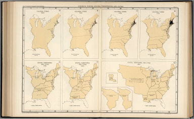
Author
[Geological Survey (U.S.), Stoll, H. George, Hammond Incorporated]
Full Title
Territorial growth : 1775 -- 1790 -- 1800 -- 1810 -- 1820 -- 1830 -- 1840 -- 1850 -- 1860 -- 1870 -- 1880 -- 1900 -- 1920 -- United States and outlying areas : 1970 / compiled by H. George Stoll, Hammond Incorporated, 1967; rev. by U. S. Geological Survey, 1970.
List No
14359.103
Note
Fourteen historical maps representing the United States, featuring territorial expansion from 1775 - the time of the original thirteen colonies - to 1970, including territories beyond the continental. Maps show political boundaries, bodies of water, drainage, coastlines and islands. Maps include legends, as well as explanatory notes and a scale statement (scales differ). With an inset map within the maps dated 1870, 1880, 1900 and 1920: Alaska. Colored lithograph. Together, maps are 42 x 65 cm, on double sheet 49 x 71 cm. Maps appear in Special subject maps section, subsection History.
Author
[Geological Survey (U.S.), Hammond Incorporated]
Full Title
Presidential elections and political parties : 1796 -- 1800 -- 1804 -- 1808 -- 1812 -- 1816 -- 1820 -- 1824 -- 1828 -- 1832 -- 1836 -- 1840 -- 1844 -- 1848 -- 1852 -- 1856 -- 1860 -- 1864 -- 1868 -- 1872 -- 1876 -- 1880 -- 1884 -- 1888 -- 1892 -- 1896 -- 1900 -- 1904 -- 1908 -- 1912 -- 1916 -- 1920 -- 1924 -- 1928 -- 1932 -- 1936 -- 1940 -- 1944 -- 1948 -- 1952 -- 1956 -- 1960 -- 1964 -- 1968 / compiled by Hammond Incorporated, 1969.
List No
14359.105
Note
Forty-four historical maps representing the United States, featuring presidential elections and political parties from 1796 to 1968. Maps show political boundaries, bodies of water, coastlines and islands. Maps include legends and pie charts, as well as a scale statement. With two inset maps within the maps dated 1960, 1964, and 1968: Hawaii -- Alaska. Also, with a timeline of presidents, from Washington to Nixon. Colored lithograph. Together, maps are 42 x 65 cm, on double sheet 49 x 71 cm. Accompanying descriptive text on page 129. Maps appear in Special subject maps section, subsection History.
Author
[Geological Survey (U.S.), United States. Department of Agriculture, United States. Soil Conservation Service, United States. Department of Agriculture. Economic Research Service, United States. Farmers Home Administration]
Full Title
Soil conservation service programs by farm production regions : 1966 / compiled from information provided by U. S. Soil Conservation Service, 1967 -- Conservation payments by farm production regions : 1966 / compiled from Economic Research Service, Farm income situation, FIS-205, Washingon, U. S. Dept. of Agric., 1967, table 10 -- Commodity credit corporation loans : cumulative 1933-1965 / compiled from U. S. Dept. of Agriculture, Agriculture statistics: 1966, Washington, U. S. Govt. Print. Off., 1966, table 748 -- Payments for selected programs by farm production regions : 1966 / compiled from Economic Research Service, Farm income situation, FIS-205, Washingon, U. S. Dept. of Agric., 1967, table 10 -- Farmers home administration and rural electrification administration loans by farm production regions : 1966 / compiled from U. S. Dept. of Agriculture, Agriculture statistics: 1966, Washington, U. S. Govt. Print. Off., 1966, tables 740 and 741; and information provided by Farmers Home Administration, 1968.
List No
14359.124
Note
Five economic maps representing the United States, featuring agricultural conservation programs, payments and loans, as of 1966. Maps also show political boundaries, bodies of water, coastlines and islands. Maps include legends, as well as bar scales and scale statements (scales differ). Presented with Albers Equal Area Projection. With two inset maps within each map: Principal islands of Hawaii -- Alaska. Colored lithograph. Together, maps are 42 x 31 cm, on sheet 49 x 35 cm. Maps appear in Special subject maps section, subsection Economic : Agriculture.
Author
Geological Survey (U.S.)
Full Title
Oil production and reserves : 1966 -- Natural gas production and reserves : 1966 -- Natural gas liquids production and reserves : 1966 -- Coal production and reserves, anthracite, bituminous, and lignite : 1966 / compiled by U. S. Geologic Survey, 1968 -- Oil shale and tar sands : 1965 -- Nuclear materials : 1967 -- Organic fuels, production and consumption : Total petroleum production, billion barrels of crude oil equivalent -- Oil production, billion barrels -- Gas production, trillion cubic feet -- Coal production, million short tons -- Oil consumption -- Gas consumption -- Coal consumption.
List No
14359.136
Note
Six mineral maps and seven charts representing the United States, featuring the geographic locations of energy materials - such as oil, natural gas and coal - as of 1967. Maps show the production and reserves of energy materials, as well as political boundaries, bodies of water, coastlines and islands. Maps include legends, as well as bar scales and scale statements. Presented with Albers Equal Area Projection. With two inset maps within each map: Principal islands of Hawaii -- Alaska. Charts show production and consumption. Colored lithograph. Together, maps and charts are 42 x 31 cm, on sheet 49 x 35 cm. Accompanying descriptive text on page 177. Maps and charts appear in Special subject maps section, subsection Economic : Mineral and energy resources.
Author
[Geological Survey (U.S.), United States. Federal Power Commission]
Full Title
Electric energy production : 1966 / compiled from Federal Power Commission, Electric power statistics, monthly repts., Washington, U. S. Govt. Print. Off., 1966, tables 1, 2, and 9 -- Electric energy consumption : 1966.
List No
14359.139
Note
Two mineral maps representing the United States, featuring the geographic locations of electric energy production and consumption, as of 1966. Maps also show political boundaries, bodies of water, coastlines and islands. Maps include legends, as well as bar scales and scale statements. Presented with Albers Equal Area Projection. With two inset maps within each map: Principal islands of Hawaii -- Alaska. Colored lithograph. Maps are each 20 x 31 cm, on sheet 49 x 35 cm. Accompanying descriptive text on page 177. Maps appear in Special subject maps section, subsection Economic : Mineral and energy resources.
Author
[Geological Survey (U.S.), U.S. Census Bureau]
Full Title
Wholesale trade : 1963 / adapted from U. S. Bureau of the Census, Retail trade in the United States: 1963, GE-50, no. 20, Washington, U. S. Govt. Print Off., 1963, map 1:5,000,000.
List No
14359.170
Note
Business map representing the United States, featuring the geographic locations of wholesale trade, showing total sales in dollars, as well as the percentage of change in sales from 1958 to 1963. Map also shows political boundaries, bodies of water, drainage, coastlines and islands. Includes a legend, as well as a bar scale and scale statement. Presented with Albers Equal Area Projection. With three inset maps: Massachusetts, Connecticut & Rhode Island -- Principal islands of Hawaii -- Alaska. Colored lithograph. Map is 43 x 66 cm, on double sheet 49 x 71 cm. Appears in Special subject maps section, subsection Economic : Business.
Author
[Geological Survey (U.S.), United States. Federal Aviation Administration]
Full Title
Air flights and facilities : 1965 / compiled from data provided by the Federal Aviation Administration.
List No
14359.175
Note
Transportation map representing the United States, featuring the geographic locations of airports and flight routes, as of 1965. Map also shows political boundaries, time zones, bodies of water, drainage, coastlines and islands. Includes a legend, as well as a bar scale and scale statement. Presented with Albers Equal Area Projection. With two inset maps: Principal islands of Hawaii -- Alaska. Colored lithograph. Map is 43 x 66 cm, on double sheet 49 x 71 cm. Appears in Special subject maps section, subsection Economic : Transportation.
Author
[Geological Survey (U.S.), U.S. Census Bureau]
Full Title
Selected population characteristics / compiled from U. S. Bureau of the Census, Census of population: 1960, v. 1, pt. A, Washington, U. S. Govt. Print Off., 1961 -- Population density : 1960.
List No
14359.180
Note
Chart and statistical map representing the United States, featuring the geographic density of population, including for major cities, as of 1960. Map also shows political boundaries, bodies of water, coastlines and islands. Includes a legend, as well as a bar scale and scale statement. Presented with Albers Equal Area Projection. With two inset maps: Principal islands of Hawaii -- Alaska. Chart shows populations for cities, including the change in population from 1950 to 1960. Colored lithograph. Map and chart are each 20 x 31 cm, on sheet 49 x 35 cm. Map and chart appear in Special subject maps section, subsection Socio-Cultural.
Author
[Geological Survey (U.S.), U.S. Census Bureau]
Full Title
American Indian population : 1960 / adapted from U. S. Bureau of the Census, American Indians in the United States: 1960, GE-50, no. 14, Washington, U. S. Govt. Print Off., 1967, map 1:5,000,000.
List No
14359.193
Note
Statistical map representing the United States, featuring the geographic density of the indigenous population, as of 1960. Map also shows political boundaries, bodies of water, drainage, coastlines and islands. Includes a legend, as well as a bar scale and scale statement. Presented with Albers Equal Area Projection. With two inset maps: Principal islands of Hawaii -- Alaska. Colored lithograph. Map is 43 x 66 cm, on double sheet 49 x 71 cm. Appears in Special subject maps section, subsection Socio-Cultural.
Author
[Geological Survey (U.S.), U.S. Census Bureau]
Full Title
Median family income : 1959 / compiled from U. S. Bureau of the Census, County and city data book: 1962, Washington, U. S. Govt. Print Off., 1962, table 2, item 22; Census of population: 1960, PC(S1)-48, Washington, U. S. Govt. Print Off., 1965, table 3.
List No
14359.196
Note
Statistical map representing the United States, featuring the geographic density of population according to the median family income in 1959. Map also shows political boundaries, bodies of water, drainage, coastlines and islands. Includes a legend, as well as a bar scale and scale statement. Presented with Albers Equal Area Projection. With two inset maps: Principal islands of Hawaii -- Alaska. Colored lithograph. Map is 43 x 66 cm, on double sheet 49 x 71 cm. Appears in Special subject maps section, subsection Socio-Cultural.
Author
[Geological Survey (U.S.), Hirt, Howard E., Cohen, Saul B., United States. Office of Education]
Full Title
Institutions of higher education / compiled by Howard E. Hirt, Bridgewater State College and Saul B. Cohen, Clark University, 1964, revised from U. S. Office of Education, Education directory, 1964-1965, Washington, U. S. Govt. Print Off., 1965, pt. 3, p. 211-218.
List No
14359.202
Note
Statistical map representing the United States, featuring the geographic locations of higher education institutions, as of 1965. Map also shows political boundaries, bodies of water, drainage, coastlines and islands. Includes a legend, as well as a bar scale and scale statement. Presented with Albers Equal Area Projection. With twenty-nine inset maps: 1. New York City area -- 1a. New York City -- 2. Pittsburgh -- 3. Baltimore -- 4. Washington -- 5. Trenton -- 6. Philadelphia -- 7. Nashville -- 8. Atlanta -- 9. New Orleans -- 10. Chicago -- 11. San Diego -- 12. Los Angeles -- 13. San Francisco - Oakland -- 14. Portland -- 15. Denver -- 16. Minneapolis - St. Paul -- 17. Milwaukee -- 18. Kansas City -- 19. St. Louis -- 20. Cincinnati -- 21. Cleveland -- 22. Massachusetts, Connecticut & Rhode Island -- 22a. Boston -- 22b. Providence -- 23. Detroit -- 24. Buffalo -- Principal islands of Hawaii -- Alaska. Colored lithograph. Map is 43 x 66 cm, on double sheet 49 x 71 cm. Accompanying descriptive text on pages 268 and 270. Appears in Special subject maps section, subsection Socio-Cultural.
Author
[Geological Survey (U.S.), U. S. Coast and Geodetic Survey]
Full Title
Horizontal control, status as of July 1, 1968 : [United States] / adapted from U. S. Coast and Geodetic Survey, Status of horizontal control, United States, July 1, 1968, Washington, 1968.
List No
14359.239
Note
Map representing the United States, featuring horizontal control surveys in mapping, as of 1968. Shows the geographic locations of different types of horizontal control, such as adjusted and unadjusted first and second-order. Also shows political boundaries, bodies of water, drainage, coastlines and islands. Includes latitudinal and longitudinal lines, and a legend, as well as a bar scale and scale statement. With two inset maps: Principal islands of Hawaii -- Alaska. Colored lithograph. Map is 43 x 66 cm, on double sheet 49 x 71 cm. Accompanied by descriptive text here, and on page 307. Appears in Special subject maps section, subsection Mapping and charting.
Author
Geological Survey (U.S.)
Full Title
World around the United States.
List No
14359.249
Note
World map featuring the position of the United States within the globe, as of 1970. Shows political boundaries, capital cities, bodies of water, coastlines and islands. Includes concentric circles around the United States indicating distance, as well as a scale statement and explanatory notes. Presented with Azimuthal Equidistant Projection. Colored lithograph. Map is 23 x 23 cm, on sheet 49 x 35 cm. Appears in Special subject maps section, subsection World.
Author
[Geological Survey (U.S.), U.S. Census Bureau, National Geographic Society (U.S.)]
Full Title
United States exports and imports of commodities : 1967 / compiled by U. S. Bureau of the Census: U. S. exports, 1967, FT 455, annual, table 3; U. S. general imports, 1967, FT 455, annual, table 3, Washington, U. S. Govt. Print. Off., 1968. Base map by National Geographic Society, The world, 1:63,360,000; rev. by U. S. Geol. Survey, 1968.
List No
14359.251
Note
World map featuring United States exports and imports of commodities in 1967. Shows streams of commerce between the United States and other nations, national borders, bodies of water, drainage, glaciers, coastlines and islands. Includes latitudinal and longitudinal lines, as well as a legend, bar scale, scale statement and explanatory notes. With three inset charts: Total exports, by commodity group -- Total imports, by commodity group -- Exports and imports by commodity group. Presented with Van der Grinten Projection. Colored lithograph. Map is 42 x 65 cm, on double sheet 49 x 71 cm. Appears in Special subject maps section, subsection World.
Author
[Geological Survey (U.S.), Harrison, Richard Edes]
Full Title
Shaded relief / Richard Edes Harrison, 1969.
List No
14359.261
Note
An experimental printing of Richard Edes Harrison's hand drawn relief map of 1964. This became the base topography of sheets 56-57, Shaded Relief by Harrison dated 1969. Not part of the atlas but acquired with a set of individual maps some of which were sold as single sheets by the U.S. Geological Survey.
Author
Rand McNalley & Company
Full Title
(Covers to) Road atlas : Supplement to Rand McNally commercial atlas service. Rand McNally & Company, Publishers, New York, Chicago, San Francisco.
List No
14003.001
Note
Includes "Quick Index" listing states with page numbers. Bound in green paper wrappers. "By issuing the Road Maps in this single volume we are able to give subscribers for the Commercial Atlas Service a complete series (United States, Canada, and Mexico) based on the latest information available at the time of publication."
Author
Rand McNalley & Company
Full Title
Rand McNally road atlas of the United States, Canada and Mexico. Rand McNally & Company, New York, Chicago, San Francisco.
List No
14003.002
Note
Includes Indexes: State and province maps -- City Maps. Table of contents lists: A guide to places of interest -- Mileage map of the United States -- Mileage chart of the United States -- Mileage chart of Mexico -- Motoring in Canada and Mexico. Copyright 1948 by Rand McNally & Company, Chicago. Made in U.S.A.
Author
Rand McNalley & Company
Full Title
Rand McNally road map : United States.
List No
14003.010
Note
Road map of the United States, showing interstate and state highways, paved and dirt roads, ferries and boatlines. Includes legend, compass rose, time zones, and bar scale with scale statement: One inch equals approximately 131 miles. Features index to national parks and monuments. Copyright by Rand McNally & Company, Chicago, Ill. Lithographed in the U.S.A.
Author
Rand McNalley & Company
Full Title
Rand McNally : Transcontinental mileage chart of the United States.
List No
14003.053
Note
Mileage chart of United States, showing distances between cities, also displayed in chart below map. Includes compass rose and time zones. With 2 insets: Milage distances between principal cities -- Yellowstone National Park. Copyright by Rand McNally & Company, Chicago, Ill. Lithographed in the U.S.A.
Author
[Powell, John Wesley, 1834-1902, United States Geological Survey (USGS), Gannett, Henry, 1846-1914, King, Harry]
Full Title
(Composite to) (Map of the) United States. Compiled under the director of Henry Gannett, Chief Topographer, by Harry King, Chief Draughtsman. Department of the Interior, United States Geological Survey, J. W. Powell, Director. 1890. Edition of April 1891. Engraved by Julius Bien & Co. New York. (Sheet 9).
List No
14054.011
Note
Composite to 9-sheet USGS topographic map of the United States. Conveys topography with contour lines, which include elevation figures. Shows state boundaries, cities and towns, railroads, drainage, and national parks, as well as Native American territories and reservations. Title, statement of responsibility, and descriptive text at lower right. Map originally published in 1890; this edition 1891.
Author
Rand McNally and Company
Full Title
(Covers to) Rand McNally Official Road Atlas of the United States. Copyright 1934 by Rand McNally & Company. Chicago, San Francisco, New York. Made in U.S.A.
List No
4245.001
Note
This issue not listed in Phillips. With ads for Johnson's Wax. 1934 edition covering the entire United States with the latest states and regional maps. 48 pages 36 x26 cm., with index to State maps and Regional maps. Bound in soft cover, with title "Rand McNally official auto road atlas of the United States. 1934". Individual maps have title: "Rand McNally junior auto road map of ..... [etc.]". Includes list and description of National Parks and Monuments. S.C. Johnson & Son, Inc. advertisement inside and on back cover.
Author
Rand McNally and Company
Full Title
(Title Page to) Rand McNally Official Road Atlas of the United States. Copyright 1934 by Rand McNally & Company. Chicago, San Francisco, New York. Made in U.S.A.
List No
4245.002
Note
This issue not listed in Phillips. With ads for Johnson's Wax. 1934 edition covering the entire United States with the latest states and regional maps. 48 pages 36 x26 cm., with index to State maps and Regional maps. Bound in soft cover, with title "Rand McNally official auto road atlas of the United States. 1934". Individual maps have title: "Rand McNally junior auto road map of ..... [etc.]". Includes list and description of National Parks and Monuments. S.C. Johnson & Son, Inc. advertisement inside and on back cover.
Author
Rand McNally and Company
Full Title
Rand McNally Junior Auto Road Map of the United States. Copyright by Rand McNally & Company. Chicago, Ill. Made in U.S.A. P.3259.
List No
4245.003
Note
Color map. Includes explanation, and alphabetical index of cities and towns, giving populations and Key to map. U.S. interstate highways shown in red. Shows U.S. inter-state highway marker. Relief shown by hachures.
Author
Clason Map Company
Full Title
(Covers to) Clason's Touring Atlas Of The United States And Canada. An Accurate Guide to the best roads of every state. Featuring 40 Large Maps Revised Annually. Showing the Latest Paving and Surfacing in Every State. New Census Figures f or Populations of Cities and Towns. Published by Clason Map Company. General Office 1525 Tremont Place, Denver, Colo. Copyrighted, 1931. The Clason Map Co.
List No
4423.001
Author
Clason Map Company
Full Title
(Title Page to) Clason's Touring Atlas Of The United States And Canada. An Accurate Guide to the best roads of every state. Featuring 40 Large Maps Revised Annually. Showing the Latest Paving and Surfacing in Every State. New Census Figures f or Populations of Cities and Towns. Published by Clason Map Company. General Office 1525 Tremont Place, Denver, Colo. Copyrighted, 1931. The Clason Map Co.
List No
4423.002
Author
Clason Map Company
Full Title
In and out maps of the principal cities showing highway connections. ( Continued on page 49). Copyright by Clason Map Co. Denver.
List No
4423.003
Note
48 uncolored maps. (continued on page 49). showing roads and highway connections in major cities in the United States.
Author
Clason Map Company
Full Title
(Text Page to) Touring Atlas of the United States and Canada. Published and Copyrighted by: The Clason Map Company, General Office, Denver, Colorado.
List No
4423.004
Note
This page includes: Tables of distances; Alphabetical lists of speed limits, and states registration for visiting motorist; and Index of maps.
Author
Clason Map Company
Full Title
Paving and road distances on the United States highways. Showing principal through routes. Published and Copyrighted: Clason Map. Map No. R-106 A. (at head of map) Key map of planning transcontinental tours - Paved highways shown in solid lines.
List No
4423.005
Note
Uncolored map. Includes text and road legend. Relief shown by hachures.
Author
Clason Map Company
Full Title
(Text Page to) Logs of the United States Highways.
List No
4423.006
Note
Includes text and logs of the United States and Canadian provincial Highways.
Author
U.S. Department of Agriculture, Weather Bureau
Full Title
(United States) Weather Map. January 1, 1901. Published by Authority of the Secretary of Agriculture.
List No
9734.002
Author
Baker, Harriet E.
Full Title
(Title Page to) Harriet E. Baker's Book of Penmanship & Maps. At Mr. Dunham's School Windsor Vermont March 31, 1819.
List No
8307.002
Note
The existence of this book of penmanship throws interesting light on our other book of penmanship by Frances Henshaw, our 2501.000. This book by Harriet Baker is dated four years earlier, 1819, and from another school in Windsor, Vermont (Henshaw's school was in Middlebury, Vermont). Generally, the two books follow very similar structure, both the text and the maps, which would indicate that the production of these books of penmanship was more frequent than previously thought and also suggests that there was a common template used, even by different schools, in their construction. It can be said that Baker's maps are exquisite, perhaps a bit more so than Henshaw's, but Henshaw's text descriptions of the states are more elaborate than Baker's. For some reason, Baker omits maps of New York, Pennsylvania, South Carolina, Kentucky, Indiana, Illinois and Michigan, while including descriptions of most of them. Henshaw has no map or description of Michigan or Illinois. For the sources of the maps and text, see our entry for Henshaw's book, 2501.000. The Osher Map Library has a copy of another book of penmanship, also from Mr. Dunham's School in Windsor Vermont, titled “Catharine M. Cook’s Book of Penmanship at Mr. Dunham’s School, Windsor, Vermont, June 15th, 1818”
Author
Baker, Harriet E.
Full Title
(Description of) New Hampshire. (to accompany) Harriet E. Baker's Book of Penmanship & Map. At Mr. Dunham's School Windsor Vermont March 31, 1819.
List No
8307.019
Note
A short description of the state of New Hampshire. Hand lettered text.
Author
Baker, Harriet E.
Full Title
New Hampshire. (to accompany) Harriet E. Baker's Book of Penmanship & Map. At Mr. Dunham's School Windsor Vermont March 31, 1819.
List No
8307.020
Note
Outline color map by county. Showing cities and towns, and rivers.
Author
Baker, Harriet E.
Full Title
(Description of) Connecticut. (to accompany) Harriet E. Baker's Book of Penmanship & Map. At Mr. Dunham's School Windsor Vermont March 31, 1819.
List No
8307.025
Note
A short description of the state of Connecticut surrounded by vines. Hand lettered text.
Author
Baker, Harriet E.
Full Title
Connecticut. (to accompany) Harriet E. Baker's Book of Penmanship & Map. At Mr. Dunham's School Windsor Vermont March 31, 1819.
List No
8307.026
Note
Outline color map by county. Showing cities and towns, and rivers. Relief shown by hachures.
Author
Baker, Harriet E.
Full Title
(Description of) New Jersey. (to accompany) Harriet E. Baker's Book of Penmanship & Map. At Mr. Dunham's School Windsor Vermont March 31, 1819.
List No
8307.031
Note
A short description of the state of New jersey. Hand lettered text.
Author
Baker, Harriet E.
Full Title
New Jersey. (to accompany) Harriet E. Baker's Book of Penmanship & Map. At Mr. Dunham's School Windsor Vermont March 31, 1819.
List No
8307.032
Note
Outline color map by county, with decorative cartouche. Showing cities and towns, and rivers. Relief shown by hachures.
Author
Shell Oil Company
Full Title
Shell Map of the United States (cover title). Shell Highway Map of United States. 7-DD-1956-4.
List No
5840.003
Author
Burr, David H., 1803-1875
Full Title
Map of the United States Of North America With parts of the Adjacent Countries, By David H. Burr. (Late Topographer to the Post Office.) Geographer to the House of Representatives of the U.S. John Arrowsmith. Entered ... July 10th, 1839, by David H. Burr ... District of Columbia.
List No
0104.001
Note
This is the "Map of the United States of North America..." from Burr's American Atlas which consists of 13 separate sheets dissected & mounted on linen. In full color by state, country, or region. In 8 sections mounted on linen. Label on back states "No. 1. United States."
Author
Robert Sayer and John Bennett (Firm)
Full Title
(Covers to) The American Military Pocket Atlas; Being An approved Collection of Correct Maps, Both General and Particular, of The British Colonies; Especially those which now are, or probably may be The Theatre of War: Taken principally from the actual Surveys and judicious Observations of Engineers De Brahm and Romans; Cook, Jackson, and Collet; Maj. Holland, and other Officers, Employed in His Majesty's Fleets and Armies. London. Printed for R. Sayer and J. Bennet, Map and Print-Sellers (No. 53) Fleet-street.
List No
0875A
Author
Robert Sayer and John Bennett (Firm)
Full Title
(Title Page to) The American Military Pocket Atlas; Being An approved Collection of Correct Maps, Both General and Particular, of The British Colonies; Especially those which now are, or probably may be The Theatre of War: Taken principally from the actual Surveys and judicious Observations of Engineers De Brahm and Romans; Cook, Jackson, and Collet; Maj. Holland, and other Officers, Employed in His Majesty's Fleets and Armies. London. Printed for R. Sayer and J. Bennet, Map and Print-Sellers (No. 53) Fleet-street.
List No
0875B
Note
This small hand atlas has six early maps, three of which are particularly important to the mapping of the American Revolution: The Seat of War in the Northern Colonies and The seat of War in the Middle British Colonies (both derived from the Evans/Pownall maps), and the Seat of War in the Southern Colonies (by Bernard Romans). Nicknamed the "Holster Atlas" because it was made for the used of British army officers. All maps in outline color, folded and bound into book with paper covered boards and quarter leather with "American Pocket Atlas" stamped in gilt on the spine.
Author
Robert Sayer and John Bennett (Firm)
Full Title
(Text Page in) The American Military Pocket Atlas; Being An approved Collection of Correct Maps, Both General and Particular, of The British Colonies; Especially those which now are, or probably may be The Theatre of War: Taken principally from the actual Surveys and judicious Observations of Engineers De Brahm and Romans; Cook, Jackson, and Collet; Maj. Holland, and other Officers, Employed in His Majesty's Fleets and Armies. London. Printed for R. Sayer and J. Bennet, Map and Print-Sellers (No. 53) Fleet-street.
List No
0875C
Note
Dedication note to Gov. Pownall.
Author
Robert Sayer and John Bennett (Firm)
Full Title
(Text Page in) The American Military Pocket Atlas; Being An approved Collection of Correct Maps, Both General and Particular, of The British Colonies; Especially those which now are, or probably may be The Theatre of War: Taken principally from the actual Surveys and judicious Observations of Engineers De Brahm and Romans; Cook, Jackson, and Collet; Maj. Holland, and other Officers, Employed in His Majesty's Fleets and Armies. London. Printed for R. Sayer and J. Bennet, Map and Print-Sellers (No. 53) Fleet-street.
List No
0875D
Note
Remainder of dedication (left side). Advertisement for the atlas, explaining the contents and intent ("such Maps as an Officer may take with him into the Field...").
Author
Robert Sayer and John Bennett (Firm)
Full Title
(Index Page in) The American Military Pocket Atlas; Being An approved Collection of Correct Maps, Both General and Particular, of The British Colonies; Especially those which now are, or probably may be The Theatre of War: Taken principally from the actual Surveys and judicious Observations of Engineers De Brahm and Romans; Cook, Jackson, and Collet; Maj. Holland, and other Officers, Employed in His Majesty's Fleets and Armies. London. Printed for R. Sayer and J. Bennet, Map and Print-Sellers (No. 53) Fleet-street.
List No
0875E
Note
End of advertisement note. Index to a list of the maps included.
Author
Arbuckle Bros.
Full Title
(Front cover to) Arbuckles' lllustrated Atlas of the United States of America. Copyright 1889, Arbuckle Bros. N.Y.
List No
0027A
Note
The front cover features a card with a map of the District of Columbia and a picture of the capitol.
Author
Arbuckle Bros.
Full Title
(Back cover to) Arbuckles' lllustrated Atlas of the United States of America. Copyright 1889, Arbuckle Bros. N.Y.
List No
0027B
Note
The back cover shows Alaska, featuring scenes of the whaling industry.
Author
Asher & Adams
Full Title
Asher & Adams' United States and territories. Entered according to Act of Congress in the year 1874 by Asher & Adams ... at Washington. Drawn and engraved by W.H. Holmes. (New York, 1874)
List No
0041.001
Note
Hand col. engraved map. Relief shown by hachures and spot heights. Inset map: Alaska (Scale 1:21,542,400), 340 miles to an in. Prime meridians: Greenwich and Washington.
Author
Asher & Adams
Full Title
Asher & Adams' geological map, United States and territories. Entered according to Act of Congress in the year 1874 by Asher & Adams ... at Washington. Drawn and engraved by W.H. Holmes. (New York, 1874)
List No
0041.042
Note
Hand col. engraved map. Relief shown by hachures and spot heights. Covers the lower 48 states. Prime meridians: Greenwich and Washington.
Author
[Bartholomew, John, Black, Adam & Charles]
Full Title
New York, Vermont, New Hampshire, Rhode Island, Massachusetts & Connecticut. Published by A. & C. Black. Edinburgh. Printed in Colours by Schenck & Macfariane. Edinburgh. Drawn & Engraved by J. Bartholomew, Edinburgh.
List No
0073.005
Note
States outlined in color. Land tinted. Inset of New York City.
Author
[Bartholomew, John, Black, Adam & Charles]
Full Title
Maine. Published by A. & C. Black. Edinburgh. Printed in Colours by Schenck & Macfariane. Edinburgh. Drawn & Engraved by J. Bartholomew, Edinburgh.
List No
0073.006
Note
State outlined in color. Land tinted.
Author
[Bartholomew, John, Black, Adam & Charles]
Full Title
Pennsylvania and New Jersey. Published by A. & C. Black. Edinburgh. Printed in Colours by Schenck & Macfariane. Edinburgh. Drawn & Engraved by J. Bartholomew, Edinburgh.
List No
0073.007
Note
States outlined in color. Land tinted.
Author
[Bartholomew, John, Black, Adam & Charles]
Full Title
Ohio, Indiana & Illinois. Published by A. & C. Black. Edinburgh. Printed in Colours by Schenck & Macfariane. Edinburgh. Drawn & Engraved by J. Bartholomew, Edinburgh.
List No
0073.008
Note
States outlined in color. Land tinted.
Author
[Bartholomew, John, Black, Adam & Charles]
Full Title
Michigan, Wisconsin, Iowa & Minnesota. Published by A. & C. Black. Edinburgh. Printed in Colours by Schenck & Macfariane. Edinburgh. Drawn & Engraved by J. Bartholomew, Edinburgh.
List No
0073.009
Note
States outlined in color. Land tinted.
Author
[Bartholomew, John, Black, Adam & Charles]
Full Title
Virginia, Maryland & Delware. Published by A. & C. Black. Edinburgh. Printed in Colours by Schenck & Macfariane. Edinburgh. Drawn & Engraved by J. Bartholomew, Edinburgh.
List No
0073.010
Note
States outlined in color. Land tinted.
Author
[Bartholomew, John, Black, Adam & Charles]
Full Title
North & South Carolina. Published by A. & C. Black. Edinburgh. Printed in Colours by Schenck & Macfariane. Edinburgh. Drawn & Engraved by J. Bartholomew, Edinburgh.
List No
0073.011
Note
States outlined in color. Land tinted.
Author
[Bartholomew, John, Black, Adam & Charles]
Full Title
Kentucky and Tennessee. Published by A. & C. Black. Edinburgh. Printed in Colours by Schenck & Macfariane. Edinburgh. Drawn & Engraved by J. Bartholomew, Edinburgh.
List No
0073.012
Note
States outlined in color. Land tinted.
Author
[Bartholomew, John, Black, Adam & Charles]
Full Title
Missouri and Arkansas. Published by A. & C. Black. Edinburgh. Printed in Colours by Schenck & Macfariane. Edinburgh. Drawn & Engraved by J. Bartholomew, Edinburgh.
List No
0073.013
Note
States outlined in color. Land tinted.
Author
[Bartholomew, John, Black, Adam & Charles]
Full Title
Georgia & Florida. Published by A. & C. Black. Edinburgh. Printed in Colours by Schenck & Macfariane. Edinburgh. Drawn & Engraved by J. Bartholomew, Edinburgh.
List No
0073.014
Note
States outlined in color. Land tinted. Inset of Continuation of Florida.
Author
[Bartholomew, John, Black, Adam & Charles]
Full Title
Alabama. Published by A. & C. Black. Edinburgh. Printed in Colours by Schenck & Macfariane. Edinburgh. Drawn & Engraved by J. Bartholomew, Edinburgh.
List No
0073.015
Note
State outlined in color. Land tinted.
Author
[Bartholomew, John, Black, Adam & Charles]
Full Title
Mississippi & Lousiana. Published by A. & C. Black. Edinburgh. Printed in Colours by Schenck & Macfariane. Edinburgh. Drawn & Engraved by J. Bartholomew, Edinburgh.
List No
0073.016
Note
States outlined in color. Land tinted.
Author
[Bartholomew, John, Black, Adam & Charles]
Full Title
Texas, Part of New Mexico. Published by A. & C. Black. Edinburgh. Printed in Colours by Schenck & Macfariane. Edinburgh. Drawn & Engraved by J. Bartholomew, Edinburgh.
List No
0073.017
Note
States outlined in color. Land tinted.
Author
[Bartholomew, John, Black, Adam & Charles]
Full Title
Western States, including California, Oregon, Utah, Washington, New Mexico, Nebraska, Kansas, Indian Territory, &c. Published by A. & C. Black. Edinburgh. Printed in Colours by Schenck & Macfariane. Edinburgh. Drawn & Engraved by J. Bartholomew, Edinburgh.
List No
0073.018
Note
States outlined in color. Land tinted.
Author
Bradford, Thomas G.
Full Title
(Covers to) An Illustrated Atlas, Geographical, Statistical, And Historical, Of The United States And The Adjacent Countries. By T.G. Bradford. Boston: Weeks, Jordan, And Company. New York: Wiley And Putnam. (on verso) Entered ... 1838, by Thomas G. Bradford ... Massachusetts. Cambridge: Stereotyped And Printed By Folsom, Wells, And Thurston, Printers To The University.
List No
0089A
Author
Bradford, Thomas G.
Full Title
(Title Page One to) An Illustrated Atlas, Geographical, Statistical, And Historical, Of The United States And The Adjacent Countries. By T.G. Bradford. Boston: Weeks, Jordan, And Company. New York: Wiley And Putnam. (on verso) Entered ... 1838, by Thomas G. Bradford ... Massachusetts. Cambridge: Stereotyped And Printed By Folsom, Wells, And Thurston, Printers To The University.
List No
0089B
Note
Beautifully illustrated full color title page.
Author
Bradford, Thomas G.
Full Title
(Title Page Two to) An Illustrated Atlas, Geographical, Statistical, And Historical, Of The United States And The Adjacent Countries. By T.G. Bradford. Boston: Weeks, Jordan, And Company. New York: Wiley And Putnam. (on verso) Entered ... 1838, by Thomas G. Bradford ... Massachusetts. Cambridge: Stereotyped And Printed By Folsom, Wells, And Thurston, Printers To The University.
List No
0089C
Note
Title page without decoration. On the verso is the copyright date of 1838.
Author
Bradford, Thomas G.
Full Title
(Contents to) An Illustrated Atlas, Geographical, Statistical, And Historical, Of The United States And The Adjacent Countries. By T.G. Bradford. Boston: Weeks, Jordan, And Company. New York: Wiley And Putnam. (on verso) Entered ... 1838, by Thomas G. Bradford ... Massachusetts. Cambridge: Stereotyped And Printed By Folsom, Wells, And Thurston, Printers To The University.
List No
0089D
Author
Bradford, Thomas G.
Full Title
North America. Entered ... 1838, by T.G. Bradford ... Massachusetts. Engraved by G.W. Boynton.
List No
0089.002
Note
Map in full color.
Author
Bradford, Thomas G.
Full Title
United States. Entered ... 1838, by T.G. Bradford ... Massachusetts.
List No
0089.005
Note
Map in full color by state or territory.
Full Title
Etats-Unis d'Amerique. La lettre gravee par H. Mardelet, Rue St. Jacques No. 27, a Paris. Graves par (Auguste Francois?) Ales, Rue de Noyers, No. 50, a Paris. A Paris, chez J. Carez, Rue Haute-Feuille No. 18. (1825)
List No
0102.006
Note
Hand colored engraved map. Relief shown by hachures. Also covers part of Northern Mexico. Prime meridians: Washington and Paris.
Full Title
Carte de l'adjonction progressive des divers etats au territoire et a l'union constitutionnelle des Etats-Unis de l'Amerique du Nord. 1825.
List No
0102.007
Note
Hand colored engraved map. Relief shown by hachures.
Full Title
Carte chronologique des Etats-Unis, presentant les principaux evenements de leurs annales, depuis leur etablissement jusqu'a la Declaration de l'Independance. Fonderie et Imprimerie de J. Carez. (1825)
List No
0102.008
Note
Hand colored engraved table.
Full Title
Tableau compare des constitutions des Etats-Unis. Fonderie et Imprimerie de J. Carez. (1825)
List No
0102.009
Note
Hand colored engraved table. Includes text at bottom.
Author
Burr, David H., 1803-1875
Full Title
(Covers to) (The American Atlas).
List No
0104A
Author
[Carey, H. C., Lea, I.]
Full Title
(Covers to) A Complete Historical, Chronological, And Geographical American Atlas, Being A Guide To The History Of North And South America, And The West Indies ... To The Year 1822. According To The Plan Of Le Sage's Atlas And Intended As A Companion To Lavoisne's Improvement Of That Celebrated Work. Philadelphia: H.C. Carey And I. Lea, Chestnut Street. 1822. (on verso) ... T.H. Palmer, Printer.
List No
0122A
Author
[Carey, H. C., Lea, I.]
Full Title
(Title Page to) A Complete Historical, Chronological, And Geographical American Atlas, Being A Guide To The History Of North And South America, And The West Indies ... To The Year 1822. According To The Plan Of Le Sage's Atlas And Intended As A Companion To Lavoisne's Improvement Of That Celebrated Work. Philadelphia: H.C. Carey And I. Lea, Chestnut Street. 1822. (on verso) ... T.H. Palmer, Printer.
List No
0122B
Note
1st Edition; Fielding Lucas engraved most of the maps. The 1823 edition was unchanged in most copies, a few have minor map updates, and one (see our copy) has all of the 1827 edition maps while still retaining the 1823 title page and most of the text. The 1827 edition includes much new material, with all the maps and text updated, except for the Washington, D.C., and Michigan maps. A French edition by Buchon was published in 1825, an abridged London edition in 1823 (see our copies), and a German edition by C.F. Weiland in 1824-1828 (P1225, Espenhorst 1.6.3). This was the first American Atlas that was modeled on Le Sage's plan of having explanatory text surrounding the maps. The maps are beautifully drawn and colored. Lucas went on to publish his own General Atlas in 1823, using similar maps but without the text. Rebound into half leather tan paper covered boards with "American Atlas. 1822." stamped in gilt along the spine.
Author
[Carey, H. C., Lea, I.]
Full Title
(Advertisement for) A Complete Historical, Chronological, And Geographical American Atlas, Being A Guide To The History Of North And South America, And The West Indies ... To The Year 1822. According To The Plan Of Le Sage's Atlas And Intended As A Companion To Lavoisne's Improvement Of That Celebrated Work. Philadelphia: H.C. Carey And I. Lea, Chestnut Street. 1822. (on verso) ... T.H. Palmer, Printer.
List No
0122C
Author
[Carey, H. C., Lea, I.]
Full Title
(Contents and Index to) A Complete Historical, Chronological, And Geographical American Atlas, Being A Guide To The History Of North And South America, And The West Indies ... To The Year 1822. According To The Plan Of Le Sage's Atlas And Intended As A Companion To Lavoisne's Improvement Of That Celebrated Work. Philadelphia: H.C. Carey And I. Lea, Chestnut Street. 1822. (on verso) ... T.H. Palmer, Printer.
List No
0122D
Author
[Carey, H. C., Lea, I.]
Full Title
United States Of America. No. 5. Engraved by B. Tanner.
List No
0122.004
Note
In full color by state or region.
Author
Finley, Anthony
Full Title
(Covers to) A New American Atlas, Designed Principally To Illustrate The Geography Of The United States Of North America; In Which Every Country In Each State And Territory Of The Union Is Accurately Delineated, As Far As At Present Known: The Whole Compiled From The Latest And Most Authentic Information. Philadelphia: Published By Anthony Finley, At The North-East Corner Of Chestnut And Fourth Streets. 1826.
List No
0278A
Note
Bound in half leather marbled paper covered boards with red leather; label stamped with "Finley's American Atlas" in gilt.
Author
Finley, Anthony
Full Title
(Title Page to) A New American Atlas, Designed Principally To Illustrate The Geography Of The United States Of North America; In Which Every Country In Each State And Territory Of The Union Is Accurately Delineated, As Far As At Present Known: The Whole Compiled From The Latest And Most Authentic Information. Philadelphia: Published By Anthony Finley, At The North-East Corner Of Chestnut And Fourth Streets. 1826.
List No
0278B
Note
This atlas was Finley's attempt to compete with Henry Tanner's American Atlas - the maps are grouped in much the same arrangement as Tanner used and the cartography and engraving are equal to Tanner, although the scale and map size are smaller. There are only two issues that we have seen, both dated 1826 on the title page, but with different dates on the maps. In the first issue, the maps are dated 1824-26; in the second issue (this copy) the maps are dated 1826-27. Finley continued to publish the maps as pocket maps until 1831 when he sold his map and atlas copyrights to Mitchell, who reissued this American Atlas only once, in 1831 (see our #3884) but continued to issue the pocket maps, with updates, until about 1850. Bound in half leather marbled paper covered boards with red leather label stamped with "Finley's American Atlas" in gilt. Full color.
Author
Finley, Anthony
Full Title
(Index to) A New American Atlas, Designed Principally To Illustrate The Geography Of The United States Of North America; In Which Every Country In Each State And Territory Of The Union Is Accurately Delineated, As Far As At Present Known: The Whole Compiled From The Latest And Most Authentic Information. Philadelphia: Published By Anthony Finley, At The North-East Corner Of Chestnut And Fourth Streets. 1826.
List No
0278C
Author
Finley, Anthony
Full Title
Map of The United States Constructed From the latest Authorities. 1825. Copyright Secured. J.H. Young Sc. Published by A. Finley Philada.
List No
0278.002
Note
In full color by state or territory. The information west of the Mississippi attributed to Major S.H. Long. Inset statistical table details square mileage and population by states and territories. Each capital is given along with a population breakdown by prinicipal city and town.
Author
Finley, Anthony
Full Title
Map of the United States, Constructed from the Latest Authorities, 1827.
List No
0279.006
Author
Finley, Anthony
Full Title
Map of the United States Constructed from the Latest Authorities. 1827. Copyright secured. Published by A. Finley, Philada. Engraved by J.H. Young.
List No
0280.002
Note
Relief shown by hachures. Prime meridian Washington. Statistical table of state attributes. Cites contributions of Mjor S.H. Long to information west of the Mississippi River.
Author
[Gray, Frank A., Gray, O.W.]
Full Title
Gray's New Map of the United States. By Frank A. Gray. (insets) Alaska. Sketch Showing the Westward Movement of the Centre of Population. Copyright 1879 by O.W. Gray & Son.
List No
0312.007
Author
[Gray, Frank A., Gray, O.W.]
Full Title
Gray's Historical Maps of the United States by Frank A. Gray.
List No
0312.077
Author
[Gray, O.W., Hitchcock, Charles H.]
Full Title
Gray's Geological Map of the United States by Prof. Charles H. Hitchcock. Copyright 1882 by O.W. Gray & Son.
List No
0312.079
Author
Blodget, Lorin
Full Title
Climatological Map of the United States Showing Average Temperature, Amount of Rain Fall &c. by Lorin Blodget.
List No
0312.082
Note
Date estimated.
Author
[Gray, Frank A., Gray, O.W.]
Full Title
Gray's Botanical and Zoological Maps of the United States. Copyright 1877 by O.W.Gray & Son.
List No
0312.084
Author
Humboldt, Alexander von, 1769-1859
Full Title
Carte Du Mexique et des Pays Limitrophes Situes Au Nord et a l'est Dressee d'apres la Grande Carte de la Nouvelle Espagne De Mr. A. De Humboldt et d'autres Materiaux par J.B. Poirson. 1811. 2. Grave par Barriere. et l'ecriture par L. Aubert. Se trouve a Paris chez F. Schoell, Libraire.
List No
0328.004
Note
An uncolored map of Mexico, the United States and the West Indies.
Author
Jefferys, Thomas
Full Title
(Covers to) The American Atlas: Or, A Geographical Description Of The Whole Continent Of America ... Engraved On Forty-Eight Copper Plates, By The Late Mr. Thomas Jefferys, Geographer to the King, and Others. London, Printed and Sold by R. Sayer and J. Bennett, Map and Print Sellers, No. 53, Fleet-Street. MDCCLXXVI.
List No
0346A
Author
Jefferys, Thomas
Full Title
(Title Page to) The American Atlas: Or, A Geographical Description Of The Whole Continent Of America ... Engraved On Forty-Eight Copper Plates, By The Late Mr. Thomas Jefferys, Geographer to the King, and Others. London, Printed and Sold by R. Sayer and J. Bennett, Map and Print Sellers, No. 53, Fleet-Street. MDCCLXXVI.
List No
0346B
Note
One of the most important atlases of the American Revolutionary War period. There are 22 maps on 29 sheets. The majority of the important large scale maps of the colonies are here, appearing together for the first time after having been issued as separates by Jefferys in the 1750's and 60's. This copy is the 1st 1776 edition, with the Quebec map, without the Lake Champlain map, as issued. This copy is the same as NMM 361, except the title page says 48 copper plates rather then the 49 on NMM 361, and on the NY/NJ map it is Major Holland rather than Capt. Holland (our NY/NJ map says Major-the 1775 says Capt-our index omits Holland-the reproduction atlas map copy says Major, and Carver is eliminated (why?); probably indicates that this was slightly before the NMM 361, as the 1775 title page is identical to this one (although we have not seen it yet-relying on P1165), except for the date. Summary of editions: 1775 (actually issued in 1776, has Evans Middle Colonies map, P1165); 1776 1st issue (our copy with 48 on TP, Quebec replaces Evans, N.Y- & N.J. is dated 1776, rather than 1775 and adds Pownall corrections and improvements); 1776 2nd issue (NMM 361, 49 on TP); 1777 (1776 on TP, N. Amer changes from Bowen/Gibson to Pownall version with 1777 on map, adds L. Champlain, P1166 -our reproduction copy); 1778 (P3659a, NMM 362, no changes from 1777); 1782 (P1169, no changes except Phillips says this copy has 1783 ed of N. Amer., inserted-later?) Our TP is a transition from 1775 to NMM361; NMM361 anticipates the Lake Champlain map in saying 49 plates. Covers are half leather brown cloth covered boards with "Jeffery's American Atlas. London MDCCLXXVI" stamped in gilt on the spine.
Author
Jefferys, Thomas
Full Title
(Index to) The American Atlas: Or, A Geographical Description Of The Whole Continent Of America ... Engraved On Forty-Eight Copper Plates, By The Late Mr. Thomas Jefferys, Geographer to the King, and Others. London, Printed and Sold by R. Sayer and J. Bennett, Map and Print Sellers, No. 53, Fleet-Street. MDCCLXXVI.
List No
0346C
Author
Melish, John
Full Title
Map of the American Coast, from Lynhaven Bay to Narraganset Bay, by John Melish.
List No
0495.002
Note
Fold-out map in outline color stretching from Long Island Sound to Norfolk, Virginia.
Author
Melish, John
Full Title
Map of the Seat of War in North America. J. Melish del. H.S. Tanner, Dirext. Entered as the Art Directs, and Published by John Melish, Philadelphia.
List No
0495.004
Note
Large fold-out map in delicate outline color stretching from Labrador to Michigan and Ohio. A table of population is included.
Author
Melish, John
Full Title
Southern Section of the United States including Florida &c. by John Melish. Entered ... by John Melish ... 1 March 1813.
List No
0495.008
Note
Large fold-out map in outline color. A small inset map of the Bermudas Isles is included. A statistical chart is included showing population and state area.
Author
[Paullin, Charles O., Wright, John K.]
Full Title
Plate 2. Physical Geography and Vegetation. Relief; Soil Regions. Physical Divisions. Vegetation Regions.
List No
0702.005
Author
[Paullin, Charles O., Wright, John K.]
Full Title
Plate 3. Forests; Growing Season. Area of Virgin Forest 1620. Area of Virgin Forest 1850. Area of Virgin Forest 1926. National Forest 1930. Average Length of Growing Season.
List No
0702.006
Author
[Paullin, Charles O., Wright, John K.]
Full Title
Plate 4. Climate. Snow Cover. Droughts. Relative Humidity. Cloudiness. Pressure.
List No
0702.007
Author
[Paullin, Charles O., Wright, John K.]
Full Title
Plate 5. Climate. Temperature. Rainfall.
List No
0702.008
Author
[Paullin, Charles O., Wright, John K.]
Full Title
Plate 6. Mineral Resources. Coal Fields, Distribution and Production of Iron Ore.
List No
0702.009
Author
[Paullin, Charles O., Wright, John K.]
Full Title
Plate 7. Mineral Resources. Oil and Gas Fields. Gold, Silver, and Copper Districts.
List No
0702.010
Author
[Paullin, Charles O., Wright, John K.]
Full Title
Plate 9. Cartography 1492-1867. Cantino Map, ca. 1502. (Facsimile).
List No
0702.012
Author
[Paullin, Charles O., Wright, John K.]
Full Title
Plate 13. Cartography 1492-1867. Verrazano Map, 1529. (Facsimile).
List No
0702.016
Author
[Paullin, Charles O., Wright, John K.]
Full Title
Plate 14. Cartography 1492-1867. Harleian Map ca. 1536. (Facsimile).
List No
0702.017
Author
[Paullin, Charles O., Wright, John K.]
Full Title
Plate 15. Cartography 1492-1867. Mercator Map, 1569. (Facsimile).
List No
0702.018
Author
[Paullin, Charles O., Wright, John K.]
Full Title
Plate 16. Cartography 1492-1867. Lemoyne Map, 1591. (Facsimile).
List No
0702.019
Author
[Paullin, Charles O., Wright, John K.]
Full Title
Plate 17. Cartography 1492-1867. Cortes Map, 1520. Turin Map, ca. 1523. Vizcaino Map, 1603. Molineaux-Wright Map, 1600. Tattonus Map, 1600. (Facsimiles).
List No
0702.020
Author
[Paullin, Charles O., Wright, John K.]
Full Title
Plate 18. Cartography 1492-1867. Smith Map, 1612. Champlain Map, 1612. (Facsimiles).
List No
0702.021
Author
[Paullin, Charles O., Wright, John K.]
Full Title
Plate 19. Cartography 1492-1867. Smith Map, 1616. (Facsimile).
List No
0702.022
Author
[Paullin, Charles O., Wright, John K.]
Full Title
Plate 20. Cartography 1492-1867. Hondius Map, 1630. Sanson, 1656. Jesuit Map 1672. Raffeix Map, 1688. (Facsimiles).
List No
0702.023
Author
[Paullin, Charles O., Wright, John K.]
Full Title
Plate 21. Cartography 1492-1867. De Laet Map, 1630. (Facsimile).
List No
0702.024
Author
[Paullin, Charles O., Wright, John K.]
Full Title
Plate 22. Cartography 1492-1867. Delisle Map, 1700. Gentil Map, ca. 1700. (Facsimiles).
List No
0702.025
Author
[Paullin, Charles O., Wright, John K.]
Full Title
Plate 23. Delisle Map, 1703. Delisle Map 1750. Bellin Map, 1743. (Facsimiles).
List No
0702.026
Author
[Paullin, Charles O., Wright, John K.]
Full Title
Plate 24. Cartography 1492-1867. Delisle Map, 1718. (Facsimile).
List No
0702.027
Author
[Paullin, Charles O., Wright, John K.]
Full Title
Plate 25. Cartography 1492-1867. Muller Map, 1754. Vancouver Map, 1798. (Facsimiles).
List No
0702.028
Author
[Paullin, Charles O., Wright, John K.]
Full Title
Plate 26. Cartography 1492-1867. Evans Map, 1755. (Facsimile).
List No
0702.029
Author
[Paullin, Charles O., Wright, John K.]
Full Title
Plate 27. Cartography 1492-1867. Popple Map, 1733. (Facsimile).
List No
0702.030
Author
[Paullin, Charles O., Wright, John K.]
Full Title
Plate 28. Cartography 1492-1867. Lewis Map, 1804. (Facsimile).
List No
0702.031
Author
[Paullin, Charles O., Wright, John K.]
Full Title
Plate 29. Cartography 1492-1867. Arrowsmith Map, 1814. (Facsimile).
List No
0702.032
Author
[Paullin, Charles O., Wright, John K.]
Full Title
Plate 30. Cartography 1492-1867. Pike Map, 1810. Humboldt Map, 1811. (Facsimiles).
List No
0702.033
Author
[Paullin, Charles O., Wright, John K.]
Full Title
Plate 31. Cartography 1492-1867. Bonneville Map, 1837. Greenhow Map. 1840. Pike Map of Mississippi River, 1810. (Facsimiles).
List No
0702.034
Author
[Paullin, Charles O., Wright, John K.]
Full Title
Plate 32. Cartography 1492-1867. Clark Map, 1810. Chapin Map, 1839. Smith Map, 1843. Colton Map, 1867. (Facsimiles).
List No
0702.035
Author
[Paullin, Charles O., Wright, John K.]
Full Title
Plate 33. Indians. Indian Tribes and Linguistic Stocks, 1650.
List No
0702.036
Author
[Paullin, Charles O., Wright, John K.]
Full Title
Plate 34. Indians. Indian Battles, 1521-1700. Indian Battles, 1701-1800. Indian Battles, 1801-1845. Indian Battles, 1846-1890.
List No
0702.037
Author
[Paullin, Charles O., Wright, John K.]
Full Title
Plate 35. Indians. Indian Reservations, 1840. Indian Reservations, 1875.
List No
0702.038
Author
[Paullin, Charles O., Wright, John K.]
Full Title
Plate 36. Indians. Indian Reservations, 1900. Indian Reservations, 1930.
List No
0702.039
Author
[Paullin, Charles O., Wright, John K.]
Full Title
Plate 37. Indians. Indian Missions, 1567-1861.
List No
0702.040
Author
[Paullin, Charles O., Wright, John K.]
Full Title
Plate 39. Explorers. French Explorations in the West, 1673-1743 (1794). American Explorations in the West, 1803-1852.
List No
0702.042
Note
Shows routes of 52 exploers.
Author
[Paullin, Charles O., Wright, John K.]
Full Title
Plate 40. Lands. Divisions of Land near Philadelphia, about 1730. (Facsimile).
List No
0702.043
Author
[Paullin, Charles O., Wright, John K.]
Full Title
Plate 41. Lands. Possessions of European States in Eastern North America after the Treaty of Paris, 1763. Plat of ... the United States N.W. of the River Ohio (Facsimile). Colonies or States Proposed or Organized by Settlers West of the Allegheny Mountains,1775-1785. A Colonial Town: Wethersfield, Connecticut, 1641 (Facsimile). Specimen Surveys in the Virginia Military Reserve, Ross County, Ohio, 1799-1825 (Facsimile).
List No
0702.044
Author
[Paullin, Charles O., Wright, John K.]
Full Title
Plate 42. Lands. Colonial Grants, 1703-1732 (Facsimile).
List No
0702.045
Author
[Paullin, Charles O., Wright, John K.]
Full Title
Plate 43. Lands. Colonial Grants, 1603-1732. Allotments of Land, Dorchester, Massachusetts, 1660 (Facsimile).
List No
0702.046
Author
[Paullin, Charles O., Wright, John K.]
Full Title
Plate 44. Lands. Divisions of Land in Maine, 1795. Farm of Governor John Endicott, 1668. Grants in Maine to Plymouth Colony, Lake and Others, 1753. Meredith, New Hampshire, 1770. (Facsimiles).
List No
0702.047
Author
[Paullin, Charles O., Wright, John K.]
Full Title
Plate 45. Lands. Grants of Western Lands by Georgia to Land Companies, 1789. 1875. Military Reserves, 1778 - 1816.
List No
0702.048
Author
[Paullin, Charles O., Wright, John K.]
Full Title
Plate 46. Lands. British Possessions after the Quebec Act, 1774. Proposed States According to Ordinance of 1784. Territorial Acquisitions 1783-1853.
List No
0702.049
Author
[Paullin, Charles O., Wright, John K.]
Full Title
Plate 47. Lands. Indian Cessions 1750-1890. Claims and Cessions of Western Lands, 1776-1803 Connecticut and South Carolina. Claims and Cessions of Western Lands, 1776-1802, New York. Claims and Cessions of Western Lands, 1776-1802, Virginia and Georgia. Claims and Cessions of Western Lands, 1776-1802, Massachusetts and North Carolina.
List No
0702.050
Author
[Paullin, Charles O., Wright, John K.]
Full Title
Plate 48. Lands. System of Survey of Public Lands under Act of 1796. Plan of Lystra, in Nelson County, Kentucky (Facsimile).
List No
0702.051
Author
[Paullin, Charles O., Wright, John K.]
Full Title
Plate 49. Lands. Territorial Claims and Limits on the Northwest Coast of America, 1790 - 1846.
List No
0702.052
Author
[Paullin, Charles O., Wright, John K.]
Full Title
Plate 50. Lands. Lands Granted to States for Educational and Other Purposes, 1785 - 1919. Land of the Ohio Company about 1787. George Rogers Clark Grant about 1785. Lands Granted in 1828 for Construction of Columbus and Sandusky Turnpike (Facsimiles).
List No
0702.053
Author
[Paullin, Charles O., Wright, John K.]
Full Title
Plate 51. Lands. Survey of Fairfax Lands, 1736-1737. Grant to Washington for Military Services, 1774 (Facsimiles).
List No
0702.054
Author
[Paullin, Charles O., Wright, John K.]
Full Title
Plate 52. Lands. A French Settlement, Kaskaskia, Illinois ... Plan of Settlement 1807; Specimen of Common Fields about 1809 (Facsimiles).
List No
0702.055
Author
[Paullin, Charles O., Wright, John K.]
Full Title
Plate 53. Lands. Southern Plantation, Mount Vernon, Virginia: Mansion House Grounds, 1787; The Farm, 1793. A Colonial Manor, Livingston Manor, New York: The Manor, 1714; Distribution of Tenants, 1798 (Facsimiles).
List No
0702.056
Author
[Paullin, Charles O., Wright, John K.]
Full Title
Plate 54. Lands. A Modern City, Springfield, Illinois, 1915 (Facsimile).
List No
0702.057
Author
[Paullin, Charles O., Wright, John K.]
Full Title
Plate 55. Lands. A Modern City, Springfield, Illinois, 1914: Ward Map; Specimen Blocks. Large Land Holdings in Southwestern Washington, 1914. Donation Lands under Act of 1850 (Facsimiles).
List No
0702.058
Author
[Paullin, Charles O., Wright, John K.]
Full Title
Plate 56. Lands. A Western Town: Carroll, Nebraska, 1918. A Western Township Pilot Knob, Harper County, Kansas, 1919. Specimen Private Land Claims, 1835. Federal Land Grants for the Construction of Railroads and Wagon Roads, 1823-1871. Oil Land Withdrawals in California, 1915 (Facsimiles).
List No
0702.059
Author
[Paullin, Charles O., Wright, John K.]
Full Title
Plate 57. Public Lands. Public Lands of United States, 1790. Public Lands of United States, 1810.
List No
0702.060
Author
[Paullin, Charles O., Wright, John K.]
Full Title
Plate 58. Public Lands. Public Lands of United States, 1830. Public Lands of United States, 1850. Public Lands of United States, 1870. Public Lands of United States, 1890.
List No
0702.061
Author
[Paullin, Charles O., Wright, John K.]
Full Title
Plate 59. Public Lands. Public Lands of United States, 1910. Distribution of Public Lands of United States, 1929.
List No
0702.062
Author
[Paullin, Charles O., Wright, John K.]
Full Title
Plate 60. Settlement and Population, 1660-1790. Settled Areas and Population, 1660. Settled Areas and Population, 1770. Settled Areas, 1760, and Population, 1750. Settled Areas and Population, 1775. Settled Areas and Population, 1790.
List No
0702.063
Author
[Paullin, Charles O., Wright, John K.]
Full Title
Plate 61. Colonial Towns, States, Territories, and Cities. Colonial Towns, 1650. Colonial Towns, 1700. Colonial Towns, 1750. Colonial Towns, 1775. States, Territories and Cities, 1790. States, Territories and Cities, 1800. States, Territories and Cities, 1810.
List No
0702.064
Author
[Paullin, Charles O., Wright, John K.]
Full Title
Plate 62. States, Territories and Cities. States, Territories and Cities, 1820. States, Territories and Cities, 1830.
List No
0702.065
Author
[Paullin, Charles O., Wright, John K.]
Full Title
Plate 63. States, Territories and Cities. States, Territories and Cities, 1840. States, Territories and Cities, 1850.
List No
0702.066
Author
[Paullin, Charles O., Wright, John K.]
Full Title
Plate 64. States, Territories and Cities. States, Territories and Cities, 1860. States, Territories and Cities, 1870. States and Territories (Additional Maps 1845-1868). States, Territories and Cities, 1880.
List No
0702.067
Author
[Paullin, Charles O., Wright, John K.]
Full Title
Plate 65. States, Territories and Cities. States, Territories and Cities, 1890. States, Territories and Cities, 1900.
List No
0702.068
Author
[Paullin, Charles O., Wright, John K.]
Full Title
Plate 66. States, Territories and Cities. States, Territories and Cities, 1910. States, Territories and Cities, 1920.
List No
0702.069
Author
[Paullin, Charles O., Wright, John K.]
Full Title
Plate 67. States and Cities: Population. States and Cities, 1930. Slaves, 1790. Slaves, 1800. Slaves, 1810. Slaves, 1820. Slaves, 1830. Slaves, 1840.
List No
0702.070
Author
[Paullin, Charles O., Wright, John K.]
Full Title
Plate 68. Population. Slaves, 1850. Slaves, 1860. Free Negroes, 1810.
List No
0702.071
Author
[Paullin, Charles O., Wright, John K.]
Full Title
Plate 69. Population. Free Negroes, 1860. Colored Population, 1880.
List No
0702.072
Author
[Paullin, Charles O., Wright, John K.]
Full Title
Plate 70. Population: Emigration to the United States. Colored Population, 1900. Colored Population, 1930. Sources of Emigration to the United States (by decade),
List No
0702.073
Author
[Paullin, Charles O., Wright, John K.]
Full Title
Plate 71. Population. Foreign-Born Population, 1860. Foreign-Born Population, 1880.
List No
0702.074
Author
[Paullin, Charles O., Wright, John K.]
Full Title
Plate 72. Population. Foreign-Born Population, 1900. Foreign-Born White Population, 1930.
List No
0702.075
Author
[Paullin, Charles O., Wright, John K.]
Full Title
Plate 73. Population. Foreign-Born Population, German, 1880. Foreign-Born Population, German, 1900. Foreign-Born Population, German, 1930. Foreign-Born Population, Irish, 1880.
List No
0702.076
Author
[Paullin, Charles O., Wright, John K.]
Full Title
Plate 74. Population. Foreign-Born Population, Irish, 1900. Foreign-Born Population, Irish, 1930.
List No
0702.077
Author
[Paullin, Charles O., Wright, John K.]
Full Title
Plate 75. Population. Foreign-Born Population, Swedish and Norwegian, 1880. Foreign-Born Population, Swedish and Norwegian, 1900.
List No
0702.078
Author
[Paullin, Charles O., Wright, John K.]
Full Title
Plate 76. Population. Foreign-Born Population, Swedish and Norwegian, 1790. Density of Population, 1800. Density of Population, 1810. Density of Population, 1820. Density of Population, 1830. Density of Population, 1840.
List No
0702.079
Author
[Paullin, Charles O., Wright, John K.]
Full Title
Plate 77. Population. Density of Population, 1850. Density of Population, 1860. Density of Population, 1870.
List No
0702.080
Author
[Paullin, Charles O., Wright, John K.]
Full Title
Plate 78. Population. Density of Population, 1880. Density of Population, 1890.
List No
0702.081
Author
[Paullin, Charles O., Wright, John K.]
Full Title
Plate 79. Density of Population. Density of Population, 1900. Density of Population, 1910. Density of Population, 1920. Density of Population, 1930.
List No
0702.082
Author
[Paullin, Charles O., Wright, John K.]
Full Title
Plate 80. Population: Colleges and Universities. Centers of Population. Colleges and Universities, 1775. Colleges and Universities, 1800. Colleges and Universities, 1830.
List No
0702.083
Author
[Paullin, Charles O., Wright, John K.]
Full Title
Plate 81. Colleges and Universities. Colleges and Universities, 1860. Colleges and Universities, 1890.
List No
0702.084
Author
[Paullin, Charles O., Wright, John K.]
Full Title
Plate 82. Churches. Congregationalist, 1775-1776. Presbyterian, 1775-1776. Protestant-Episcopal, 1775-1776. Baptist, 1775-1776. Friends, 1775-1776. German Reformed, 1776-1776. Lutheran, 1775-1776. Dutch Reformed, 1775-1776. Methodist, 1775-1776. Catholic, 1775-1776. Minor Denominations, 1775-1776. Minor Denominations, 1775-1776.
List No
0702.085
Author
[Paullin, Charles O., Wright, John K.]
Full Title
Plate 83. Churches. Methodist, 1860. Baptist, 1860.
List No
0702.086
Author
[Paullin, Charles O., Wright, John K.]
Full Title
Plate 84. Churches. Congregational, 1860. Protestant-Episcopal, 1860. Lutheran, 1860. "Christian," 1860. Reformed, 1860. Friends, 1860. Presbyterian, 1860.
List No
0702.087
Author
[Paullin, Charles O., Wright, John K.]
Full Title
Plate 85. Churches. Catholic, 1860. Methodist, 1890.
List No
0702.088
Author
[Paullin, Charles O., Wright, John K.]
Full Title
Plate 86. Churches. Baptist, 1890. Presbyterian, 1890.
List No
0702.089
Author
[Paullin, Charles O., Wright, John K.]
Full Title
Plate 87. Churches. Catholic, 1890. Congregational, 1890. Protestant - Episcopal, 1890. Lutheran, 1890.
List No
0702.090
Author
[Paullin, Charles O., Wright, John K.]
Full Title
Plate 88. Churches. Disciples of Christ, 1890. Reformed, 1890.
List No
0702.091
Author
[Paullin, Charles O., Wright, John K.]
Full Title
Plate 89. Negotiation for Peace, 1779 - 1783. Negotiations for Peace (Base, Mitchell's Map of North America, 1755, second edition reduced size).
List No
0702.092
Author
[Paullin, Charles O., Wright, John K.]
Full Title
Plate 90. Negotiation for Peace, 1779 - 1783. Negotiations for Peace (Northeast Section) (Base, Mitchell's Map of North America, 1755, second edition, reduced size).
List No
0702.093
Author
[Paullin, Charles O., Wright, John K.]
Full Title
Plate 91. International Boundary Disputes. The Northwest Angle of Nova Scotia and the Highlands. Isle Royal to Lake of the Woods. St. Croix River.
List No
0702.094
Author
[Paullin, Charles O., Wright, John K.]
Full Title
Plate 92. International Boundary Disputes. Islands in the Bay of Fundy. Definition of Boundary in Bay of Fundy.
List No
0702.095
Author
[Paullin, Charles O., Wright, John K.]
Full Title
Plate 93. International Boundary Disputes. Northwesternmost Head of the Connecticut River. Southward and Westward of Lake of the Woods. Rocky Mountains to Pacific Ocean. The Forty-Fifth Parallel. Old Southern Boundary. Southeastern Boundary of Louisiana Purchase. Sabine River. Southern and Western Boundary of New Mexico.
List No
0702.096
Author
[Paullin, Charles O., Wright, John K.]
Full Title
Plate 94. International Boundary Disputes. United States - Mexican Boundary. Gadsden's and Other Lines.
List No
0702.097
Author
[Paullin, Charles O., Wright, John K.]
Full Title
Plate 95. International Boundary Disputes. Western Boundary of Louisiana Purchase (Drainage and Projection from Melish's Map of the United States, 1818). Texas-Mexican Boundary. Elimination of Bancos.
List No
0702.098
Author
[Paullin, Charles O., Wright, John K.]
Full Title
Plate 96. International Boundary Disputes. Alaska-Canadian Boundary. Horseshoe Reef. San Juan Water Boundary.
List No
0702.099
Author
[Paullin, Charles O., Wright, John K.]
Full Title
Plate 97. Colonial and State Boundary Disputes. Massachusetts - New Hampshire Boundary. New York - New Hampshire and Vermont Boundary. Eastern Boundary of Rhode Island. Connecticut - Rhode Island Boundary. New York - Connecticut Boundary. Northern Boundary of New Jersey. Pennsylvania - Virginia Boundary. Texas - Oklahoma Boundary, Portion near Forks of Red River.
List No
0702.100
Author
[Paullin, Charles O., Wright, John K.]
Full Title
Plate 98. Colonial and State Boundary Disputes. Western Boundary of Maryland. Ohio - Michigan Boundary. Missouri - Iowa Boundary.
List No
0702.101
Author
[Paullin, Charles O., Wright, John K.]
Full Title
Plate 99. Colonial and State Boundary Disputes. Virginia - Tennessee Boundary. Louisiana - Mississippi Boundary, Portion near Lake Borgne. Illinois - Wisconsin Boundary.
List No
0702.102
Author
[Paullin, Charles O., Wright, John K.]
Full Title
Plate 100. Colonial and State Boundary Disputes. North Carolina - South Carolina, Georgia. Maryland - Pennsylvania, Delaware.
List No
0702.103
Author
[Paullin, Charles O., Wright, John K.]
Full Title
Plate 101. State Boundary Disputes. Michigan - Wisconsin Boundary. Oklahoma - Texas Boundary along the Red River.
List No
0702.104
Author
[Paullin, Charles O., Wright, John K.]
Full Title
Plate 102. Presidential Elections. Electoral Vote for President, 1789. Electoral Vote for President, 1792. Electoral Vote for President, 1796. Presidential and Other Elections, 1800. Presidential and Other Elections, 1804. Presidential and Other Elections, 1808. Presidential and Other Elections, 1812. Presidential and Other Elections, 1816.
List No
0702.105
Author
[Paullin, Charles O., Wright, John K.]
Full Title
Plate 103. Presidential Elections. Presidential Election 1820. Presidential Election 1824. Presidential Election 1828. Presidential Election 1832.
List No
0702.106
Author
[Paullin, Charles O., Wright, John K.]
Full Title
Plate 104. Presidential Elections. Presidential Election 1836. Presidential Election 1840. Presidential Election 1844. Presidential Election 1848.
List No
0702.107
Author
[Paullin, Charles O., Wright, John K.]
Full Title
Plate 105. Presidential Elections. Presidential Election 1852. Presidential Election 1856. Presidential Election 1860. Presidential Election 1864.
List No
0702.108
Author
[Paullin, Charles O., Wright, John K.]
Full Title
Plate 106. Presidential Elections. Presidential Election 1868. Presidential Election 1872.
List No
0702.109
Author
[Paullin, Charles O., Wright, John K.]
Full Title
Plate 107. Presidential Elections. Presidential Election 1876. Presidential Election 1880.
List No
0702.110
Author
[Paullin, Charles O., Wright, John K.]
Full Title
Plate 108. Presidential Elections. Presidential Election 1884. Presidential Election 1888. Presidential Election 1892. Presidential Election 1896.
List No
0702.111
Author
[Paullin, Charles O., Wright, John K.]
Full Title
Plate 109. Presidential Elections. Presidential Election 1900. Presidential Election 1904.
List No
0702.112
Author
[Paullin, Charles O., Wright, John K.]
Full Title
Plate 110. Presidential Elections. Presidential Election 1908. Presidential Election 1912.
List No
0702.113
Author
[Paullin, Charles O., Wright, John K.]
Full Title
Plate 111. Presidential Election. Presidential Election 1916. Presidential Election 1920. Presidential Election 1924. Presidential Election 1928.
List No
0702.114
Author
[Paullin, Charles O., Wright, John K.]
Full Title
Plate 112. Congressional Measures. Assumption of State Debts, July 26, 1790. Act Incorporating U.S. Bank, February 8, 1791. Alien and Sedition Acts, February 25, 1799. Embargo Act, December 21, 1807.
List No
0702.115
Author
[Paullin, Charles O., Wright, John K.]
Full Title
Plate 113. Congressional Measures. Declaration of War, June 4, 1812. General Tariff Act, April 8, 1816. "Bonus" Bill, February 8, 1817. Missouri Compromise, March 2, 1820.
List No
0702.116
Author
[Paullin, Charles O., Wright, John K.]
Full Title
Plate 114. Congressional Measures. General Tariff Act, April 22, 1828. Maysville Road Bill, April 29, 1830. General Tariff Act, June 28, 1832. Independent Treasury Act, June 30, 1840. Public Land Act, July 6, 1841. Annexation of Texas, January 25, 1845. Walker Tariff Act, July 3, 1846. Compromise of 1850, September 6, 1850.
List No
0702.117
Author
[Paullin, Charles O., Wright, John K.]
Full Title
Plate 115. Congressional Measures. Kansas - Nebraska Act, May 22, 1854. General Tariff Act, March 2, 1857.
List No
0702.118
Author
[Paullin, Charles O., Wright, John K.]
Full Title
Plate 116. Congressional Measures. Thirteenth Amendment, January 31, 1865. Reconstruction Act, March 2, 1867.
List No
0702.119
Author
[Paullin, Charles O., Wright, John K.]
Full Title
Plate 117. Congressional Measures. Enforcement Act, April 6, 1871. Resumption of Specie Payments, January 7, 1875. Silver Purchase Act, February 28, 1878. General Tariff Act, March 2, 1883.
List No
0702.120
Author
[Paullin, Charles O., Wright, John K.]
Full Title
Plate 118. Congressional Measures. Reagan Interstate Commerce Bill, January 8, 1885. Bland Free Coinage Bill, March 24, 1892.
List No
0702.121
Author
[Paullin, Charles O., Wright, John K.]
Full Title
Plate 119. Congressional Measures. Dingley Tariff Act, March 31, 1897. Gold Standard Act, December 18, 1899.
List No
0702.122
Author
[Paullin, Charles O., Wright, John K.]
Full Title
Plate 120. Congressional Measures. Payne - Aldrich Tariff Act, July 31, 1909. Canadian Reciprocity Act, April 21, 1911. Underwood Tariff Act, May 8, 1913. War Resolution, April 5, 1917.
List No
0702.123
Author
[Paullin, Charles O., Wright, John K.]
Full Title
Plate 121. Congressional Measures. Prohibition Resolution, December 17, 1917. Woman Suffrage Resolution, May 21, 1919.
List No
0702.124
Author
[Paullin, Charles O., Wright, John K.]
Full Title
Plate 122. Congressional Measures. Fordney Tariff Act, July 21, 1921. Smoot-Hawley Tariff Act, June 14, 1930.
List No
0702.125
Author
[Paullin, Charles O., Wright, John K.]
Full Title
Plate 123. Reforms. Abolition of Slavery, 1800. Abolition of Slavery, 1820. Abolition of Slavery, 1850. Abolition of Slavery, 1854. Abolition of Slavery.1863.
List No
0702.126
Author
[Paullin, Charles O., Wright, John K.]
Full Title
Plate 124. Reforms. Abolition of Slavery, 1865. Property Qualifications for Suffrage, 1775. Property Qualifications for Suffrage, 1800.
List No
0702.127
Author
[Paullin, Charles O., Wright, John K.]
Full Title
Plate 125. Reforms. Property Qualifications for Suffrage, 1830. Property Qualifications for Suffrage, 1860.
List No
0702.128
Author
[Paullin, Charles O., Wright, John K.]
Full Title
Plate 126. Reforms. Property Qualifications for Suffrage, 1890. Property Qualifications for Suffrage, 1920. Woman Suffrage, 1875. Woman Suffrage, 1900.
List No
0702.129
Author
[Paullin, Charles O., Wright, John K.]
Full Title
Plate 127. Reforms. Woman Suffrage, 1915. Woman Suffrage, 1919.
List No
0702.130
Author
[Paullin, Charles O., Wright, John K.]
Full Title
Plate 128. Woman Suffrage, 1920. Prohibition, 1845.
List No
0702.131
Author
[Paullin, Charles O., Wright, John K.]
Full Title
Plate 129. Reforms. Prohibition, 1855. Prohibition, 1875. Prohibition, 1890. Prohibition, 1905.
List No
0702.132
Author
[Paullin, Charles O., Wright, John K.]
Full Title
Plate 130. Reforms. Prohibition, 1915. Prohibition, 1919.
List No
0702.133
Author
[Paullin, Charles O., Wright, John K.]
Full Title
Plate 131. Reforms. Prohibition, 1920. Schools: Expenditures per Capita, 1870-1871. Schools: Expenditures per Capita, 1902-1903. Schools: Expenditures per Capita, 1927-1928. Schools: Compulsory Attendance, 1852-1918, and Minimum Term, 1930.
List No
0702.134
Author
[Paullin, Charles O., Wright, John K.]
Full Title
Plate 132. Reforms. Women's Compensation, 1931. Vocational Rehabilitation, 1931. Mothers' Pensions, 1931. Old Age Pensions, 1931. Women's Working Hours, 1931. One Day of Rest in Seven, 1931. Minimum Age for Children in Factories and Stores, 1931. Civil Service Requirements for Employees of State Departments of Labor, 1931. State Public Employment Officesm 1931.
List No
0702.135
Author
[Paullin, Charles O., Wright, John K.]
Full Title
Plate 133. Manufacturing. Principal Manufacturing Cities, 1839. Principal Manufacturing Cities, 1859. Principal Manufacturing Cities, 1889.
List No
0702.136
Author
[Paullin, Charles O., Wright, John K.]
Full Title
Plate 134. Manufacturing. Principal Manufacturing Cities, 1919. Value Added by Manufacture, 1848. Value Added by Manufacture, 1889. Value Added by Manufacture, 1927. Wholesale Prices, 1791 - 1930.
List No
0702.137
Author
[Paullin, Charles O., Wright, John K.]
Full Title
Plate 135. Manufacturing. Iron Works 1620 - 1675. Iron and Steel Works, 1725 - 1775. Iron and Steel Works, 1810. Iron and Steel Works, 1858. Iron and Steel Works, 1878. Iron and Steel Works, 1908.
List No
0702.138
Author
[Paullin, Charles O., Wright, John K.]
Full Title
Plate 136. Manufacturing. Cotton Spinning, 1810. Cotton Spinning, 1840. Cotton Spinning, 1880.
List No
0702.139
Author
[Paullin, Charles O., Wright, John K.]
Full Title
Plate 137. Manufacturing. Cotton Spinning, 1926. Manufacture of Motor Vehicles, 1909. Manufacture of Motor Vehicles, 1927. Tractors on Farms. Horses and Mules, Two Years Old and Over.
List No
0702.140
Author
[Paullin, Charles O., Wright, John K.]
Full Title
Plate 138. Transportation. Rates of Travel, 1800. Rates of Travel, 1830. Rates of Travel, 1857. Rates of Travel, 1930 (By Railroads). Rates of Travel, 1930 (By Airways). Navigable Rivers, 1930. Canals and Canalized Rivers, 1930. Public Post Roads and Main Stage Routes, 1774. Main Post Roads, 1804. Main Post Roads, 1834. Railroads in Operation, December, 1840.
List No
0702.141
Author
[Paullin, Charles O., Wright, John K.]
Full Title
Plate 139. Transportation. Railroads, 1850 and Overland Mail 1850 - 1859. Railroads, 1860 and Overland Mail 1860 - 1869.
List No
0702.142
Author
[Paullin, Charles O., Wright, John K.]
Full Title
Plate 140. Transportation. Railroads, 1870 - 1914. The Harriman (Railroad) System, 1912, Trackage of 1914, Union Pacific (Centre and North), Southern Pacific (South), Los Angeles, San Pedro, and Salt Lake (Railroad).
List No
0702.143
Author
[Paullin, Charles O., Wright, John K.]
Full Title
Plate 141. Transportation. Western Railroads, 1880. Western Railroads, 1930. New England System, 1914. New York Central System, 1914. Pennsylvania System, 1914. Southern Railroad, 1913. The James J. Hill Railroads, 1914, Colorado and Southern (To Houston), Burlington (Centre), Northern Pacific (North), Great Northern. Air Mail Routes in Operation, 1920, 1927. Air Mail Routes in Operation, 1931. Persons per Motor Vehicle, 1913. Persons per Motor Vehicle, 1930.
List No
0702.144
Author
[Paullin, Charles O., Wright, John K.]
Full Title
Plate 142. Agriculture. Agricultural Regions, 1924. Cotton Production, 1839. Cotton Production, 1859. Cotton Production, 1889. Cotton Production, 1919. Cotton Production, 1924.
List No
0702.145
Author
[Paullin, Charles O., Wright, John K.]
Full Title
Plate 143. Agriculture. Cattle (Excluding Milch Cows), 1860. Cattle (Excluding Milch Cows), 1890. Cattle (Excluding Milch Cows), 1920. Cattle and Calves, 1925. Tobacco Production, 1839. Tobacco Production, 1859. Tobacco Production, 1889. Tobacco Production, 1919. Tobacco, Rice and Flax, 1924. Corn Production, 1839. Corn Production, 1859. Corn Production, 1889. Corn Production, 1919. Corn for Grain Production, 1924. Wheat Production, 1839. Wheat Production, 1859. Wheat Production, 1889. Wheat Production, 1919.
List No
0702.146
Author
[Paullin, Charles O., Wright, John K.]
Full Title
Plate 144. Agriculture. Spring Wheat Production, 1924. Winter Wheat Production, 1924. Improved Land, 1850. Improved Land, 1860. Improved Land, 1870. Improved Land, 1880. Improved Land, 1890. Improved Land, 1900.
List No
0702.147
|
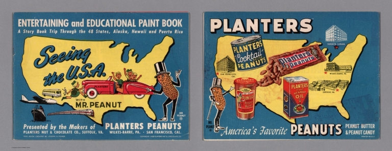


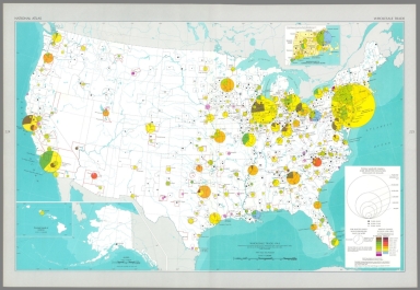


![Horizontal control, status as of July 1, 1968 : [United States].](https://www.davidrumsey.com/rumsey/Size2/RUMSEY~8~1/199/14359239.jpg)