|
Author
Vogel, Carl
Full Title
(Covers to) Karte Des Deutschen Reichs
List No
15961.001
Note
Sheets dated from 1891 to 1893.
Author
Vogel, Carl
Full Title
(Title page to) Karte Des Deutschen Reichs
List No
15961.002
Note
Sheets dated from 1891 to 1893.
Author
Vogel, Carl
Full Title
Sect. 1: Schleswig
List No
15961.003
Note
Sheets dated from 1891 to 1893.
Author
Vogel, Carl
Full Title
Sect. 2: Stralsund.
List No
15961.004
Note
Sheets dated from 1891 to 1893.
Author
Vogel, Carl
Full Title
Sect. 3: Rugenwalde.
List No
15961.005
Note
Sheets dated from 1891 to 1893.
Author
Vogel, Carl
Full Title
Sect. 4: Danzig
List No
15961.006
Note
Sheets dated from 1891 to 1893.
Author
Vogel, Carl
Full Title
Sect. 5: Konigsberg.
List No
15961.007
Note
Sheets dated from 1891 to 1893.
Author
Vogel, Carl
Full Title
Sect' 6: Emden
List No
15961.008
Note
Sheets dated from 1891 to 1893.
Author
Vogel, Carl
Full Title
Sect. 7: Hamburg
List No
15961.009
Note
Sheets dated from 1891 to 1893.
Author
Vogel, Carl
Full Title
Sect. 8: Schwerin
List No
15961.010
Note
Sheets dated from 1891 to 1893.
Author
Vogel, Carl
Full Title
Sect. 9: Stettin
List No
15961.011
Note
Sheets dated from 1891 to 1893.
Author
Vogel, Carl
Full Title
Sect. 10: Bromberg
List No
15961.012
Note
Sheets dated from 1891 to 1893.
Author
Vogel, Carl
Full Title
Sect. 11: Allenstein
List No
15961.013
Note
Sheets dated from 1891 to 1893.
Author
Vogel, Carl
Full Title
Sect. 12: Munster
List No
15961.014
Note
Sheets dated from 1891 to 1893.
Author
Vogel, Carl
Full Title
Sect. 13: Hannover
List No
15961.015
Note
Sheets dated from 1891 to 1893.
Author
Vogel, Carl
Full Title
Sect. 14: Berlin
List No
15961.016
Note
Sheets dated from 1891 to 1893.
Author
Vogel, Carl
Full Title
Sect. 15: Frankfurt A/O
List No
15961.017
Note
Sheets dated from 1891 to 1893.
Author
Vogel, Carl
Full Title
Sect. 16: Posen
List No
15961.018
Note
Sheets dated from 1891 to 1893.
Author
Vogel, Carl
Full Title
Sect. 17: Koln
List No
15961.019
Note
Sheets dated from 1891 to 1893.
Author
Vogel, Carl
Full Title
Sect. 18: Frankfurt A/M
List No
15961.020
Note
Sheets dated from 1891 to 1893.
Author
Vogel, Carl
Full Title
Sect. 19: Dresden
List No
15961.021
Note
Sheets dated from 1891 to 1893.
Author
Vogel, Carl
Full Title
Sect. 20: Gorlitz
List No
15961.022
Note
Sheets dated from 1891 to 1893.
Author
Vogel, Carl
Full Title
Sect. 21: Breslau
List No
15961.023
Note
Sheets dated from 1891 to 1893.
Author
Vogel, Carl
Full Title
Sect. 22: Strassburg I/E
List No
15961.024
Note
Sheets dated from 1891 to 1893.
Author
Vogel, Carl
Full Title
Sect. 23: Stuttgart
List No
15961.025
Note
Sheets dated from 1891 to 1893.
Author
Vogel, Carl
Full Title
Sect. 24: Regensburg
List No
15961.026
Note
Sheets dated from 1891 to 1893.
Author
Vogel, Carl
Full Title
Sect. 25: Mulhausen I/E
List No
15961.027
Note
Sheets dated from 1891 to 1893.
Author
Vogel, Carl
Full Title
Sect. 26: Augsburg
List No
15961.028
Note
Sheets dated from 1891 to 1893.
Author
Vogel, Carl
Full Title
Sect. 27: Munchen
List No
15961.029
Note
Sheets dated from 1891 to 1893.
Author
Vogel, Carl
Full Title
(Composite map of) Sect. 1-27 Karte Des Deutschen Reichs
List No
15961.030
Note
Sheets dated from 1891 to 1893.
Author
Survey of India Department
Full Title
Incidence of land revenue 1892-3 : Per acre of fully assessed cultivated area -- Per head of population. Reg. No. 305, R. & A. Dept. - Aug. 94 - 2,016. Photo., S. I. O., Calcutta.
List No
14252.061
Note
Two colored photolithographed diagrams illustrating cultivated land in proportion to acreage and population in India, in 1892 and 1893. Together, diagrams are 26 x 31 cm, on sheet 34 x 43 cm.
Author
Bartholomew, J. G. (John George), 1860-1920
Full Title
(Title Page to) Constable's Hand Atlas of India : a new series of sixty maps and plans, prepared from Ordnance Survey and other surveys under direction of J. G. Batholomew, F.R.G.S., F.R.S.E., Etc. Westminster : Archibald Constable & Company, 14 Parliament Street, MDCCCXCIII (1893).
List No
11794.002
Note
First edition atlas of India, with 60 maps, 85 pages of table of contents, index and advertisements. Bound in red cloth boards, quarter maroon goatskin with gilt crown on cover and title on spine in gilt. 60 double page full colored maps, including administrative, thematic, and regional maps.
Author
Bartholomew, J. G. (John George), 1860-1920
Full Title
Routes to India. Plate 1. The Edinburgh Geographical Institute. Copyright John Bartholmew & Co. (to accompany) Constable's Hand Atlas of India : a new series of sixty maps and plans ... J. G. Batholomew ... Westminster : Archibald Constable & Company, MDCCCXCIII (1893).
List No
11794.006
Note
Color map of the world. Shows political divisions, major cities, steamer routes, sailing vessels, railways, caravan routes and telegraph cables.
Author
Bartholomew, J. G. (John George), 1860-1920
Full Title
Indian Ocean. Plate 2. The Edinburgh Geographical Institute. Copyright John Bartholmew & Co. (to accompany) Constable's Hand Atlas of India : a new series of sixty maps and plans ... J. G. Batholomew ... Westminster : Archibald Constable & Company, MDCCCXCIII (1893).
List No
11794.007
Note
4 color maps on 2 sheets. Shows Ocean currents during S.W. and N.E. Monsoon, Ocean tides and Ocean depths.Depth shown by bathymetric tints. Prime meridian is Greenwich.
Author
Bartholomew, J. G. (John George), 1860-1920
Full Title
India : Land surface elevation. Plate 3. The Edinburgh Geographical Institute. Copyright John Bartholmew & Co. (to accompany) Constable's Hand Atlas of India : a new series of sixty maps and plans ... J. G. Batholomew ... Westminster : Archibald Constable & Company, MDCCCXCIII (1893)
List No
11794.008
Note
Color relief map of India, with inset of continuation map. Elevations shown by contours, altitude tints and spot heights in Feet. Includes elevation chart.
Author
Bartholomew, J. G. (John George), 1860-1920
Full Title
India : Land surface features. Plate 4. The Edinburgh Geographical Institute. Copyright John Bartholmew & Co. (to accompany) Constable's Hand Atlas of India : a new series of sixty maps and plans ... J. G. Batholomew ... Westminster : Archibald Constable & Company, MDCCCXCIII (1893).
List No
11794.009
Note
Color map, with inset of continuation map. Showing phytogeography and land surface features of India. Includes color explanation chart.
Author
Bartholomew, J. G. (John George), 1860-1920
Full Title
India : Geological features. Plate 5. The Edinburgh Geographical Institute. Copyright John Bartholmew & Co. (to accompany) Constable's Hand Atlas of India : a new series of sixty maps and plans ... J. G. Batholomew ... Westminster : Archibald Constable & Company, MDCCCXCIII (1893).
List No
11794.010
Note
Color map, with inset of continuation map. Showing geological features of India. Includes color explanation chart of geologic time.
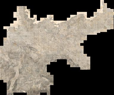
Author
Reichsamt fur Landesaufnahme
Full Title
(Composite of) Sheets 1 - 674 (Germany)
List No
5820.727
Note
Composite of Sheets 1 to 674. Date estimated based on the apparent library acquisition date usually stamped on the back of the map sheet. This map series is remarkable for the level of fine detail. As a consequence, it was scanned at 800 PPI providing four times the resolution of the typical detailed map scan of 400 PPI. At least ten separate symbols for special buildings were utilized, a method enhanced by placing an abbreviation next to the symbol. Structures with special symbols include: churches, chapels, monuments, windmills, water mills, stamp mills, forester's lodges, watchtowers, ruins, forts, quarries, clay pits, lime kilns, and coke-ovens. Factories, brick works, powder magazines electric power plants, and many other important buildings are differentiated by means of abbreviation. Houses appear as black blocks, either rectangular or shaped like the ground plan of the building. Many other features are differentiated, for example there are four different qualities of roads plus bridle paths and footpaths. Vegetation is minutely classified including separate symbols for broadleaf trees, evergreens, underbrush, heather, dry meadows, wet meadows, swamps, orchards, gardens, vineyards, and parks. Relief is shown by hachures. Spot elevations are given in meters above sea level.
Author
Reichsamt fur Landesaufnahme
Full Title
Zeichen-Erklaerung fur die Karte des Deutschen Reiches. Neue Ausgabe 1887.
List No
5820.730
Note
A highly detailed legend from the era of most of the maps in this online set. Major subdivisions are: (1) Trains, Streets, and Paths, characterized by various gauges of railways, road and path types, stations, overpasses, stopping points, etc.; (2) Political Boundaries, including country or realm boundaries, districts, counties, and other administrative units; (3) Bodies of Water, featuring a wide range of hydrography-related features including lakes, locks, fords, jetties, islands, and culverts; (4) Earth and Landforms, with vegetation and land types; (5) Dwelling Places, showing various sizes of settlements; (6) Topographic Signs, such as benchmarks, built landscape features like walls, churches, cemeteries, lime ovens, etc. There is a key linking different fonts and sizes and styles to particular features. This legend has been digitized from the Library of Congress Collection, with digital restoration work generously provided by Dr. Horst Otto Mueller from Ratzeburg, Germany. This entire map series is remarkable for the level of fine detail. As a consequence, it was scanned at 800 PPI providing four times the resolution of the typical detailed map scan of 400 PPI.
Author
Bartholomew, J. G. (John George), 1860-1920
Full Title
(Covers to) Constable's Hand Atlas of India : a new series of sixty maps and plans, prepared from Ordnance Survey and other surveys under direction of J. G. Batholomew, F.R.G.S., F.R.S.E., Etc. Westminster : Archibald Constable & Company, 14 Parliament Street, MDCCCXCIII (1893).
List No
11794.001
Note
First edition atlas of India, with 60 maps, 85 pages of table of contents, index and advertisements. Bound in red cloth boards, quarter maroon goatskin with gilt crown on cover and title on spine in gilt. 60 double page full colored maps, including administrative, thematic, and regional maps.
Author
Bartholomew, J. G. (John George), 1860-1920
Full Title
(Text Page to) Constable's Hand Atlas of India : a new series of sixty maps and plans, prepared from Ordnance Survey and other surveys under direction of J. G. Batholomew, F.R.G.S., F.R.S.E., Etc. Westminster : Archibald Constable & Company, 14 Parliament Street, MDCCCXCIII (1893).
List No
11794.003
Note
First edition atlas of India, with 60 maps, 85 pages of table of contents, index and advertisements. Bound in red cloth boards, quarter maroon goatskin with gilt crown on cover and title on spine in gilt. 60 double page full colored maps, including administrative, thematic, and regional maps.
Author
Bartholomew, J. G. (John George), 1860-1920
Full Title
(Contents to) Constable's Hand Atlas of India : a new series of sixty maps and plans, prepared from Ordnance Survey and other surveys under direction of J. G. Batholomew, F.R.G.S., F.R.S.E., Etc. Westminster : Archibald Constable & Company, 14 Parliament Street, MDCCCXCIII (1893).
List No
11794.004
Note
First edition atlas of India, with 60 maps, 85 pages of table of contents, index and advertisements. Bound in red cloth boards, quarter maroon goatskin with gilt crown on cover and title on spine in gilt. 60 double page full colored maps, including administrative, thematic, and regional maps.
Author
Bartholomew, J. G. (John George), 1860-1920
Full Title
(Composite text) Constable's Hand Atlas of India : a new series of sixty maps and plans, prepared from Ordnance Survey and other surveys under direction of J. G. Batholomew, F.R.G.S., F.R.S.E., Etc. Westminster : Archibald Constable & Company, 14 Parliament Street, MDCCCXCIII (1893).
List No
11794.005
Note
First edition atlas of India, with 60 maps, 85 pages of table of contents, index and advertisements. Bound in red cloth boards, quarter maroon goatskin with gilt crown on cover and title on spine in gilt. 60 double page full colored maps, including administrative, thematic, and regional maps.
Author
Bartholomew, J. G. (John George), 1860-1920
Full Title
Average temperature during the hot season. March to May inclusive. Average temperature during the cold season. November to February inclusive. Plate 6. The Edinburgh Geographical Institute. Copyright John Bartholmew & Co. (to accompany) Constable's Hand Atlas of India : a new series of sixty maps and plans ... J. G. Batholomew ... Westminster : Archibald Constable & Company, MDCCCXCIII (1893).
List No
11794.011
Note
2 color maps of India on 1 sheet double page. Showing average temperature during the hot and cold seasons.
Author
Bartholomew, J. G. (John George), 1860-1920
Full Title
Average rainfall during the dry season. March to May inclusive. Average rainfall during the wet season. June to October inclusive. Plate 7. The Edinburgh Geographical Institute. Copyright John Bartholmew & Co. (to accompany) Constable's Hand Atlas of India : a new series of sixty maps and plans ... J. G. Batholomew ... Westminster : Archibald Constable & Company, MDCCCXCIII (1893).
List No
11794.012
Note
2 color maps of India on 1 sheet double page. Showing average rainfall during Monsoon and dry seasons.
Author
Bartholomew, J. G. (John George), 1860-1920
Full Title
Density of population of the Indian Empire. Plate 8. The Edinburgh Geographical Institute. Copyright John Bartholmew & Co. (to accompany) Constable's Hand Atlas of India : a new series of sixty maps and plans ... J. G. Batholomew ... Westminster : Archibald Constable & Company, MDCCCXCIII (1893).
List No
11794.013
Note
Color map of India based on the density of population. Showing administrative divisions, major cities and towns. Includes color coded chart of population density. Prime meridian is Greenwich.
Author
Bartholomew, J. G. (John George), 1860-1920
Full Title
India prevailing races. Plate 9. The Edinburgh Geographical Institute. Copyright John Bartholmew & Co. (to accompany) Constable's Hand Atlas of India : a new series of sixty maps and plans ... J. G. Batholomew ... Westminster : Archibald Constable & Company, MDCCCXCIII (1893).
List No
11794.014
Note
Color ethnographical map of India, with inset of continuation map. Includes color coded chart of ethnic groups.
Author
Bartholomew, J. G. (John George), 1860-1920
Full Title
India languages. Plate 10. The Edinburgh Geographical Institute. Copyright John Bartholmew & Co. (to accompany) Constable's Hand Atlas of India : a new series of sixty maps and plans ... J. G. Batholomew ... Westminster : Archibald Constable & Company, MDCCCXCIII (1893).
List No
11794.015
Note
Color map of India, with inset of continuation map. Showing distribution of various languages in India. Includes color coded chart.
Author
Bartholomew, J. G. (John George), 1860-1920
Full Title
Christian Mission stations of the Indian Empire. Plate 11. The Edinburgh Geographical Institute. Copyright John Bartholmew & Co. (to accompany) Constable's Hand Atlas of India : a new series of sixty maps and plans ... J. G. Batholomew ... Westminster : Archibald Constable & Company, MDCCCXCIII (1893).
List No
11794.016
Note
Color map of Indian Empire. Showing location of the European and American missions Includes color coded chart. Prime meridian is Greenwich.
Author
Bartholomew, J. G. (John George), 1860-1920
Full Title
India : Animal products. Plate 12. The Edinburgh Geographical Institute. Copyright John Bartholmew & Co. (to accompany) Constable's Hand Atlas of India : a new series of sixty maps and plans ... J. G. Batholomew ... Westminster : Archibald Constable & Company, MDCCCXCIII (1893).
List No
11794.017
Note
Color map of India, with inset of continuation map. Map based on location of livestock and animal products. Includes color coded chart.
|