|
Author
Vogel, Carl
Full Title
(Covers to) Karte Des Deutschen Reichs
List No
15961.001
Note
Sheets dated from 1891 to 1893.
Author
Vogel, Carl
Full Title
(Title page to) Karte Des Deutschen Reichs
List No
15961.002
Note
Sheets dated from 1891 to 1893.
Author
Vogel, Carl
Full Title
Sect. 1: Schleswig
List No
15961.003
Note
Sheets dated from 1891 to 1893.
Author
Vogel, Carl
Full Title
Sect. 2: Stralsund.
List No
15961.004
Note
Sheets dated from 1891 to 1893.
Author
Vogel, Carl
Full Title
Sect. 3: Rugenwalde.
List No
15961.005
Note
Sheets dated from 1891 to 1893.
Author
Vogel, Carl
Full Title
Sect. 4: Danzig
List No
15961.006
Note
Sheets dated from 1891 to 1893.
Author
Vogel, Carl
Full Title
Sect. 5: Konigsberg.
List No
15961.007
Note
Sheets dated from 1891 to 1893.
Author
Vogel, Carl
Full Title
Sect' 6: Emden
List No
15961.008
Note
Sheets dated from 1891 to 1893.
Author
Vogel, Carl
Full Title
Sect. 7: Hamburg
List No
15961.009
Note
Sheets dated from 1891 to 1893.
Author
Vogel, Carl
Full Title
Sect. 8: Schwerin
List No
15961.010
Note
Sheets dated from 1891 to 1893.
Author
Vogel, Carl
Full Title
Sect. 9: Stettin
List No
15961.011
Note
Sheets dated from 1891 to 1893.
Author
Vogel, Carl
Full Title
Sect. 10: Bromberg
List No
15961.012
Note
Sheets dated from 1891 to 1893.
Author
Vogel, Carl
Full Title
Sect. 11: Allenstein
List No
15961.013
Note
Sheets dated from 1891 to 1893.
Author
Vogel, Carl
Full Title
Sect. 12: Munster
List No
15961.014
Note
Sheets dated from 1891 to 1893.
Author
Vogel, Carl
Full Title
Sect. 13: Hannover
List No
15961.015
Note
Sheets dated from 1891 to 1893.
Author
Vogel, Carl
Full Title
Sect. 14: Berlin
List No
15961.016
Note
Sheets dated from 1891 to 1893.
Author
Vogel, Carl
Full Title
Sect. 15: Frankfurt A/O
List No
15961.017
Note
Sheets dated from 1891 to 1893.
Author
Vogel, Carl
Full Title
Sect. 16: Posen
List No
15961.018
Note
Sheets dated from 1891 to 1893.
Author
Vogel, Carl
Full Title
Sect. 17: Koln
List No
15961.019
Note
Sheets dated from 1891 to 1893.
Author
Vogel, Carl
Full Title
Sect. 18: Frankfurt A/M
List No
15961.020
Note
Sheets dated from 1891 to 1893.
Author
Vogel, Carl
Full Title
Sect. 19: Dresden
List No
15961.021
Note
Sheets dated from 1891 to 1893.
Author
Vogel, Carl
Full Title
Sect. 20: Gorlitz
List No
15961.022
Note
Sheets dated from 1891 to 1893.
Author
Vogel, Carl
Full Title
Sect. 21: Breslau
List No
15961.023
Note
Sheets dated from 1891 to 1893.
Author
Vogel, Carl
Full Title
Sect. 22: Strassburg I/E
List No
15961.024
Note
Sheets dated from 1891 to 1893.
Author
Vogel, Carl
Full Title
Sect. 23: Stuttgart
List No
15961.025
Note
Sheets dated from 1891 to 1893.
Author
Vogel, Carl
Full Title
Sect. 24: Regensburg
List No
15961.026
Note
Sheets dated from 1891 to 1893.
Author
Vogel, Carl
Full Title
Sect. 25: Mulhausen I/E
List No
15961.027
Note
Sheets dated from 1891 to 1893.
Author
Vogel, Carl
Full Title
Sect. 26: Augsburg
List No
15961.028
Note
Sheets dated from 1891 to 1893.
Author
Vogel, Carl
Full Title
Sect. 27: Munchen
List No
15961.029
Note
Sheets dated from 1891 to 1893.
Author
Vogel, Carl
Full Title
(Composite map of) Sect. 1-27 Karte Des Deutschen Reichs
List No
15961.030
Note
Sheets dated from 1891 to 1893.
Author
[Gutiérrez, Tonatiúh, 1929-, Mexico. Secretaría de Industria y Comercio, Mexico. Comisión Nacional Consultiva de Pesca, Instituto Nacional de Investigaciones Biológico Pesqueras (Mexico), Mexico. Dirección General de Pesca e Industrias Conexas]
Full Title
(Covers to) Atlas pesquero nacional. Tonatiuh Gutierrez. México, 1965. Secretaría de Industria y Comercio, Comisión Nacional Consultiva de Pesca.
List No
14303.001
Note
Covers to Atlas pesquero nacional by Tonatiúh Gutiérrez, published in Mexico, 1965. Title translates to: National fishing atlas. Bound in paper. Front cover decorated with a painting of underwater scenery, with citation on verso: "La conquista de nuestros recursos marinos" [= The conquest of our marine resources], por Eleazar Molina, -1964. Back cover credits printer: Offset Publicitario Mexico, S.A.
Author
[Gutiérrez, Tonatiúh, 1929-, Mexico. Secretaría de Industria y Comercio, Mexico. Comisión Nacional Consultiva de Pesca, Instituto Nacional de Investigaciones Biológico Pesqueras (Mexico), Mexico. Dirección General de Pesca e Industrias Conexas]
Full Title
(Title Page to) Atlas pesquero nacional. Tonatiuh Gutierrez. México, 1965. Secretaría de Industria y Comercio, Comisión Nacional Consultiva de Pesca, Instituto Nacional de Investigaciones Biológico Pesqueras, Dirección General de Pesca e Industrias Conexas.
List No
14303.002
Note
Title page to Atlas pesquero nacional by Tonatiúh Gutiérrez, published in Mexico, 1965. Title translates to: National fishing atlas. Includes imprint, as well as seal: Estados Unidos Mexicanos.
Author
[Gutiérrez, Tonatiúh, 1929-, Ordáz, Gustavo Díaz, Mexico. Comisión Nacional Consultiva de Pesca, Instituto Nacional de Investigaciones Biológico Pesqueras (Mexico), Mexico. Dirección General de Pesca e Industrias Conexas]
Full Title
(Text Page to) Por mucho tiempo ... Lic. Gustavo Díaz Ordáz.
List No
14303.003
Note
Quotation to introduce Atlas pesquero nacional by Tonatiúh Gutiérrez, published in Mexico, 1965. Excerpt: Por mucho tiempo se pensó que la vida termina en las costas ... y nuestros mares son parte de la patria [= For a long time it was thought that life ends on the coasts ... and our seas are part of the homeland]. Authored by the President of Mexico from 1964 to 1970, Gustavo Díaz Ordáz. Includes black and white photographic portrait of Ordáz.
Author
[Gutiérrez, Tonatiúh, 1929-, Mexico. Secretaría de Industria y Comercio, Mexico. Comisión Nacional Consultiva de Pesca, Instituto Nacional de Investigaciones Biológico Pesqueras (Mexico), Mexico. Dirección General de Pesca e Industrias Conexas]
Full Title
(Contents to) Contenido.
List No
14303.007
Note
Table of contents to Atlas pesquero nacional by Tonatiúh Gutiérrez, published in Mexico, 1965. Lists 40 plate titles with associated plate number.
Author
[Gutiérrez, Tonatiúh, 1929-, Mexico. Secretaría de Industria y Comercio, Mexico. Comisión Nacional Consultiva de Pesca, Instituto Nacional de Investigaciones Biológico Pesqueras (Mexico), Mexico. Dirección General de Pesca e Industrias Conexas]
Full Title
Ubicacion de Mexico en el panorama pesquero mundial. Atlas pesquero nacional, 1965, Tonatiúh Gutiérrez. Lámina No. 1.
List No
14303.009
Note
Colored world map representing Mexico's fishing activity across the globe. Title translates to: Location of Mexico in the world fishing scene. Map shows political borders, coastlines, water routes and fishing locations. Includes a legend, compass rose and scale statement. With three charts: Produccion total [= Total production] -- Principales especies [= Main species] -- Aprovechamiento [= Exploitation]. Citation listed at bottom of sheet: Anuario Estadistico de Pesca. F.A.O. 1963 [Statistical Yearbook of Fisheries. F.A.O. 1963]. Map is 22 x 30 cm, on sheet 24 x 34 cm; atlas opened to double page 24 x 68 cm. Accompanied by a collage of black and white photographs showing fishing on preceding plate. Facing page - interleaved between map and collage - contains accompanying descriptive text on transparent paper, through which one can see a partial view of the collage. Text begins: Nuestro pais, localizado en América, dentro de hemisferio Norte y frente a los Océanos mayores del planeta, posee las cualidades naturales necesarias para sostener un erecimiento constante en su economía pesquera ... [= Our country, located in America, within the Northern Hemisphere and facing the major oceans of the planet, has the natural qualities necessary to sustain a constant growth in its fishing economy ... ].
Author
[Gutiérrez, Tonatiúh, 1929-, Mexico. Secretaría de Industria y Comercio, Mexico. Comisión Nacional Consultiva de Pesca, Instituto Nacional de Investigaciones Biológico Pesqueras (Mexico), Mexico. Dirección General de Pesca e Industrias Conexas]
Full Title
Los recursos pesqueros de Mexico. Atlas pesquero nacional, 1965, Tonatiúh Gutiérrez. Lámina No. 2.
List No
14303.011
Note
Colored map of Mexico representing the geographic locations of different types of fish. Title translates to: The fishing resources of Mexico. Map shows political borders, coastlines, water routes and fishing locations. Includes a legend and compass rose. Map is 24 x 34 cm; atlas opened to double page 24 x 68 cm. Accompanied by a collage of black and white photographs showing fish on preceding plate. Facing page - interleaved between map and collage - contains accompanying descriptive text on transparent paper, through which one can see a partial view of the collage. Text begins: Por la situacion geográfica de nuestro país, frente al Golfo de México y al Océano Pacífico, y con un litoral aproximado de 10,000 Kms., se presentan características oceanodas zonas, para la presencia de recursos pesqueros comerciales ... [= Due to the geographical situation of our country, facing the Gulf of Mexico and the Pacific Ocean, and with an approximate coastline of 10,000 km, there are characteristics of oceanic regions, for the presence of commercial fishing resources ... ].
Author
[Gutiérrez, Tonatiúh, 1929-, Mexico. Secretaría de Industria y Comercio, Mexico. Comisión Nacional Consultiva de Pesca, Instituto Nacional de Investigaciones Biológico Pesqueras (Mexico), Mexico. Dirección General de Pesca e Industrias Conexas]
Full Title
Los recursos techicos pesqueros de Mexico. Atlas pesquero nacional, 1965, Tonatiúh Gutiérrez. Lámina No. 3.
List No
14303.013
Note
Colored map of Mexico representing the geographic locations of fish processing. Title translates to: The technical fishing resources of Mexico. Map shows political borders, coastlines, water routes and fish processing locations. Includes a legend and compass rose. With two charts: Operacion de embarcaciones ... [= Boat operation ... ]. Map is 24 x 34 cm; atlas opened to double page 24 x 68 cm. Accompanied by a collage of black and white photographs showing fish processing on preceding plate. Facing page - interleaved between map and collage - contains accompanying descriptive text on transparent paper, through which one can see a partial view of the collage. Text begins: Es facil apreciar que el panorama pesquero de un país deberá apoyarse en un conjunto de factores, tanto naturales como técnicos, para lograr metas significativas ... [= It is easy to see that the fishing landscape of a country must be supported by a set of factors, both natural and technical, to achieve significant goals ... ].
Author
[Gutiérrez, Tonatiúh, 1929-, Mexico. Secretaría de Industria y Comercio, Mexico. Comisión Nacional Consultiva de Pesca, Instituto Nacional de Investigaciones Biológico Pesqueras (Mexico), Mexico. Dirección General de Pesca e Industrias Conexas]
Full Title
Panorama economico pesquero de Mexico. Atlas pesquero nacional, 1965, Tonatiúh Gutiérrez. Lámina No. 4.
List No
14303.015
Note
Colored map of Mexico representing the geographic locations of the fishing economy in 1964. Title translates to: Fisheries economic outlook of Mexico. Map shows political borders, coastlines, water routes and fishing economy locations. Includes a legend. With various charts, including: Tipo de explotaction [= Type of exploitation] -- Resumen nactional por especies [= National summary by species]. Map is 24 x 34 cm; atlas opened to double page 24 x 68 cm. Accompanied by a collage of black and white photographs showing coins and shrimp on preceding plate. Facing page - interleaved between map and collage - contains accompanying descriptive text on transparent paper, through which one can see a partial view of the collage. Text begins: El presente esquema nos ilustra, en lo general, la situación económica que en el año de 1964 guardó la actividad presquera ... [= The present diagram illustrates, in general, the economic situation that the presquera activity kept in 1964 ... ].
Author
[Gutiérrez, Tonatiúh, 1929-, Mexico. Secretaría de Industria y Comercio, Mexico. Comisión Nacional Consultiva de Pesca, Instituto Nacional de Investigaciones Biológico Pesqueras (Mexico), Mexico. Dirección General de Pesca e Industrias Conexas]
Full Title
Registro general de explotacion pesquera en aguas nacionales. Atlas pesquero nacional, 1965, Tonatiúh Gutiérrez. Lámina No. 5.
List No
14303.017
Note
Colored chart of Mexico representing the fishing economy from 1950 to 1964. Title translates to: General registry of fishing exploitation in national waters. Chart is 18 x 28, on sheet 24 x 34 cm; atlas opened to double page 24 x 68 cm. Accompanied by a collage of black and white photographs showing fishing and fish processing on preceding plate. Facing page - interleaved between chart and collage - contains accompanying descriptive text on transparent paper, through which one can see a partial view of the collage. Text begins: El volumen de la explotación en la nación ha sufrido en los últimos años oscilaciones constantes, y sólo puede hablarse de que a partir de 1955 la tendencia que sigue el volumen explotado ha sido de aumento lento constante ... [= The volume of exploitation in the nation has undergone constant fluctuations in recent years, and it can only be said that since 1955 the trend that the volume exploited follows has been one of constant slow increase ... ].
Author
[Gutiérrez, Tonatiúh, 1929-, Mexico. Secretaría de Industria y Comercio, Mexico. Comisión Nacional Consultiva de Pesca, Instituto Nacional de Investigaciones Biológico Pesqueras (Mexico), Mexico. Dirección General de Pesca e Industrias Conexas]
Full Title
Valor de la explotacion registrada en aguas nacionales y sus ingresos fiscales. Atlas pesquero nacional, 1965, Tonatiúh Gutiérrez. Lámina No. 6.
List No
14303.019
Note
Colored chart of Mexico representing the fishing economy income from 1950 to 1964. Title translates to: Value of the exploitation registered in national waters and its fiscal income. Includes a legend. Chart is 18 x 19, on sheet 24 x 34 cm; atlas opened to double page 24 x 68 cm. Accompanied by a collage of black and white photographs showing coins and fish on preceding plate. Facing page - interleaved between chart and collage - contains accompanying descriptive text on transparent paper, through which one can see a partial view of the collage. Text begins: La explotacion de recursos marinos se lleva a cabo en su majoría por pescadores nacionales, complementándose con extranjeros, aun cuando estos últimos representan un porcentaje pequeño, sobre todo en los últimos años ... [= The exploitation of marine resources is carried out in its majority by national fishermen, complemented by foreigners, even though the latter represent a small percentage, especially in recent years ... ].
Author
[Gutiérrez, Tonatiúh, 1929-, Mexico. Secretaría de Industria y Comercio, Mexico. Comisión Nacional Consultiva de Pesca, Instituto Nacional de Investigaciones Biológico Pesqueras (Mexico), Mexico. Dirección General de Pesca e Industrias Conexas]
Full Title
Registro de la explotacion nacional por zonas. Atlas pesquero nacional, 1965, Tonatiúh Gutiérrez. Lámina No. 7.
List No
14303.021
Note
Colored chart of Mexico representing the fishing economy according to geographic zones from 1950 to 1964. Title translates to: Register of national exploitation by zones. Chart is 21 x 25, on sheet 24 x 34 cm; atlas opened to double page 24 x 68 cm. Accompanied by a collage of black and white photographs showing fish processing on preceding plate. Facing page - interleaved between chart and collage - contains accompanying descriptive text on transparent paper, through which one can see a partial view of the collage. Text begins: En el transcurso de los años de 1950 a 1964 la explotación pesquera ha experimentado en varias zonas una situación de estancamiento, en contraste con stras zonas que han experimentado crecimientos sostenidos ... [= During the years from 1950 to 1964, fishing exploitation has experienced a stagnant situation in several regions, in contrast to other regions that have experienced sustained growth ... ].
Author
[Gutiérrez, Tonatiúh, 1929-, Mexico. Secretaría de Industria y Comercio, Mexico. Comisión Nacional Consultiva de Pesca, Instituto Nacional de Investigaciones Biológico Pesqueras (Mexico), Mexico. Dirección General de Pesca e Industrias Conexas]
Full Title
Valor comercial de la explotacion pesquera nacional y extranjera. Atlas pesquero nacional, 1965, Tonatiúh Gutiérrez. Lámina No. 8.
List No
14303.023
Note
Colored chart of Mexico representing the commercial value of fishing operations from 1953 to 1964. Title translates to: Commercial value of national and foreign fishing operations. Chart is 22 x 29, on sheet 24 x 34 cm; atlas opened to double page 24 x 68 cm. Accompanied by a collage of black and white photographs showing coins and fish on preceding plate. Facing page - interleaved between chart and collage - contains accompanying descriptive text on transparent paper, through which one can see a partial view of the collage. Text begins: Si se analizan los datos presentados en esta gráfica, salta a la vista que el litoral del Pacífico es en donde se han obtenido mayores progresos de la actividad pesquera en los últimos 12 años, ya que desde 1954 ... [= If the data presented in this graph are analyzed, it is obvious that the Pacific coast is where the greatest progress has been made in fishing activity in the last 12 years, since 1954 ... ].
Author
[Gutiérrez, Tonatiúh, 1929-, Mexico. Secretaría de Industria y Comercio, Mexico. Comisión Nacional Consultiva de Pesca, Instituto Nacional de Investigaciones Biológico Pesqueras (Mexico), Mexico. Dirección General de Pesca e Industrias Conexas]
Full Title
Registro de la explotacion nacional por entidades. Atlas pesquero nacional, 1965, Tonatiúh Gutiérrez. Lámina No. 9.
List No
14303.025
Note
Colored chart of Mexico representing the fishing economy, by region, from 1950 to 1964. Title translates to: Registry of national exploitation by regions. Chart is 21 x 30, on sheet 24 x 34 cm; atlas opened to double page 24 x 68 cm. Accompanied by a collage of black and white photographs showing fish processing on preceding plate. Facing page - interleaved between chart and collage - contains accompanying descriptive text on transparent paper, through which one can see a partial view of the collage. Text begins: El estado de Baja California Norte, desde el año de 1955, es el que ha venido explotando los mayores volúmenes de productos pesqueros del país ... [= The state of Baja California Norte, since 1955, is the one that has been exploiting the largest volumes of fishery products in the country ... ].
Author
[Gutiérrez, Tonatiúh, 1929-, Mexico. Secretaría de Industria y Comercio, Mexico. Comisión Nacional Consultiva de Pesca, Instituto Nacional de Investigaciones Biológico Pesqueras (Mexico), Mexico. Dirección General de Pesca e Industrias Conexas]
Full Title
Valor de la pesca nacional por entidades. Atlas pesquero nacional, 1965, Tonatiúh Gutiérrez. Lámina No. 10.
List No
14303.027
Note
Colored chart of Mexico representing the value of the fishing economy, by region, from 1950 to 1964. Title translates to: Value of national fishing by regions. Chart is 20 x 26, on sheet 24 x 34 cm; atlas opened to double page 24 x 68 cm. Accompanied by a collage of black and white photographs showing coins and fish on preceding plate. Facing page - interleaved between chart and collage - contains accompanying descriptive text on transparent paper, through which one can see a partial view of the collage. Text begins: Cuarto entidades, tres pertenecientes a la zona del Pacífico Norte: Sonora, Sinaloa y Baja California Norte, y una perteneciente al Golfo de México ... [= Four regions, three belonging to the North Pacific zone: Sonora, Sinaloa and Baja California Norte, and one belonging to the Gulf of Mexico ... ].
Author
[Gutiérrez, Tonatiúh, 1929-, Mexico. Secretaría de Industria y Comercio, Mexico. Comisión Nacional Consultiva de Pesca, Instituto Nacional de Investigaciones Biológico Pesqueras (Mexico), Mexico. Dirección General de Pesca e Industrias Conexas]
Full Title
Explotacion pesquera nacional por entidades. Atlas pesquero nacional, 1965, Tonatiúh Gutiérrez. Lámina No. 11.
List No
14303.029
Note
Colored chart of Mexico representing the fishing operations, by region, from 1950 to 1964. Title translates to: National fishing operation by regions. Chart is 18 x 29, on sheet 24 x 34 cm; atlas opened to double page 24 x 68 cm. Accompanied by a collage of black and white photographs showing fish processing on preceding plate. Facing page - interleaved between chart and collage - contains accompanying descriptive text on transparent paper, through which one can see a partial view of the collage. Text begins: Esta grafica comprenede aquellas entidades en las que la pesca, como actividad económica, no tiene gran importancia y por lo tanto se registran volúmenes pequeños de productos del mar ... [= This graph includes those regions in which fishing, as an economic activity, does not have great importance and therefore small volumes of seafood are recorded ... ].
Author
[Gutiérrez, Tonatiúh, 1929-, Mexico. Secretaría de Industria y Comercio, Mexico. Comisión Nacional Consultiva de Pesca, Instituto Nacional de Investigaciones Biológico Pesqueras (Mexico), Mexico. Dirección General de Pesca e Industrias Conexas]
Full Title
Valor de la pesca nacional por entidades. Atlas pesquero nacional, 1965, Tonatiúh Gutiérrez. Lámina No. 12.
List No
14303.031
Note
Colored chart of Mexico representing the value of the fishing economy, by region, from 1950 to 1964. Title translates to: Value of national fishing by regions. Chart is 20 x 27, on sheet 24 x 34 cm; atlas opened to double page 24 x 68 cm. Accompanied by a collage of black and white photographs showing coins and fish on preceding plate. Facing page - interleaved between chart and collage - contains accompanying descriptive text on transparent paper, through which one can see a partial view of the collage. Text begins: En Chiapas, el acrecentamiento en el valor de la explotación de los recursos marinos ha sido constante, experimentando los mayores incrementos en los años de 1962 y 1963 ... [= In Chiapas, the increase in the value of the exploitation of marine resources has been constant, experiencing the greatest increases in the years 1962 and 1963 ... ].
Author
[Gutiérrez, Tonatiúh, 1929-, Mexico. Secretaría de Industria y Comercio, Mexico. Comisión Nacional Consultiva de Pesca, Instituto Nacional de Investigaciones Biológico Pesqueras (Mexico), Mexico. Dirección General de Pesca e Industrias Conexas]
Full Title
Explotacion de las principales especies en aguas nacionales (registro de nacionales y extranjeras). Atlas pesquero nacional, 1965, Tonatiúh Gutiérrez. Lámina No. 13.
List No
14303.033
Note
Colored chart of Mexico representing the fishing of certain species from 1950 to 1964. Title translates to: Exploitation of the main species in national waters (registry of nationals and foreigners). Chart is 17 x 28, on sheet 24 x 34 cm; atlas opened to double page 24 x 68 cm. Accompanied by a collage of black and white photographs showing fish on preceding plate. Facing page - interleaved between chart and collage - contains accompanying descriptive text on transparent paper, through which one can see a partial view of the collage. Text excerpt: Observando el desarrollo que a través de los últimos 15 años ha tenido el volumen explotado, si se desglosa por especies, se advertirá que el atún, en el lapso de 1950-1960, fue el que representó el mayor tonelaje capturado ... [= Observing the development that through the last 15 years, if it is broken down by species, it will be noted that tuna, in the period 1950-1960, was the one that represented the greatest tonnage caught ... ].
Author
[Gutiérrez, Tonatiúh, 1929-, Mexico. Secretaría de Industria y Comercio, Mexico. Comisión Nacional Consultiva de Pesca, Instituto Nacional de Investigaciones Biológico Pesqueras (Mexico), Mexico. Dirección General de Pesca e Industrias Conexas]
Full Title
Explotacion de las principales especies en aguas nacionales (registro de nacionales y extranjeras). Atlas pesquero nacional, 1965, Tonatiúh Gutiérrez. Lámina No. 14.
List No
14303.035
Note
Colored chart of Mexico representing the fishing of certain species from 1950 to 1964. Title translates to: Exploitation of the main species in national waters (registry of nationals and foreigners). Chart is 21 x 20, on sheet 24 x 34 cm; atlas opened to double page 24 x 68 cm. Accompanied by a collage of black and white photographs showing fish on preceding plate. Facing page - interleaved between chart and collage - contains accompanying descriptive text on transparent paper, through which one can see a partial view of the collage. Text begins: La explotacion del robalo, con excepción de los años de 1951 y 1962, ha guardado un nivel constante, alrededor de las 2,500 toneladas, qunque para 1964 su volumen explotado se elevó a 3,275 toneladas ... [= The exploitation of snook, with the exception of the years 1951 and 1962, has kept a constant level, around 2,500 tons, although by 1964 its exploited volume rose to 3,275 tons ... ].
Author
[Gutiérrez, Tonatiúh, 1929-, Mexico. Secretaría de Industria y Comercio, Mexico. Comisión Nacional Consultiva de Pesca, Instituto Nacional de Investigaciones Biológico Pesqueras (Mexico), Mexico. Dirección General de Pesca e Industrias Conexas]
Full Title
Tonelaje de las embarcaciones nacionales pesqueras. Atlas pesquero nacional, 1965, Tonatiúh Gutiérrez. Lámina No. 15.
List No
14303.037
Note
Colored chart of Mexico representing the amount of fishing vessels, from 1950 to 1964. Title translates to: Tonnage of national fishing vessels. Chart is 22 x 28, on sheet 24 x 34 cm; atlas opened to double page 24 x 68 cm. Accompanied by a collage of black and white photographs showing fishing vessels on preceding plate. Facing page - interleaved between chart and collage - contains accompanying descriptive text on transparent paper, through which one can see a partial view of the collage. Text begins: Para tener una idea proximada de lo que significan en la república las unidades dedicades a la pesca, hay que tomar en cuenta su desplazamiento. Estadísticamente, las embarcaciones se han clasificado en 5 categorías ... [= To have a rough idea of what the units dedicated to fishing mean in the republic, its displacement must be taken into account. Statistically, the vessels have been classified into 5 categories ... ].
Author
[Gutiérrez, Tonatiúh, 1929-, Mexico. Secretaría de Industria y Comercio, Mexico. Comisión Nacional Consultiva de Pesca, Instituto Nacional de Investigaciones Biológico Pesqueras (Mexico), Mexico. Dirección General de Pesca e Industrias Conexas]
Full Title
Registro de las embarcaciones nacionales pesqueras. Atlas pesquero nacional, 1965, Tonatiúh Gutiérrez. Lámina No. 16.
List No
14303.039
Note
Colored chart of Mexico representing the amount of fishing vessels, from 1950 to 1964. Title translates to: Registry of national fishing vessels. Chart is 20 x 28, on sheet 24 x 34 cm; atlas opened to double page 24 x 68 cm. Accompanied by a collage of black and white photographs showing fishing vessels on preceding plate. Facing page - interleaved between chart and collage - contains accompanying descriptive text on transparent paper, through which one can see a partial view of the collage. Text begins: En los años que se consideran se aprecia que en el litoral del Pacífico el registro de embarcaciones se ha mantenido constante; una excepción lo constituyen los años de 1953, 1954 y 1963 en los que dicho registro aumentó en forma considerable ... [= In the years considered, it is appreciated that on the Pacific coast the registration of vessels has remained constant; an exception are the years of 1953, 1954 and 1963 in which said registry increased considerably ... ].
Author
[Gutiérrez, Tonatiúh, 1929-, Mexico. Secretaría de Industria y Comercio, Mexico. Comisión Nacional Consultiva de Pesca, Instituto Nacional de Investigaciones Biológico Pesqueras (Mexico), Mexico. Dirección General de Pesca e Industrias Conexas]
Full Title
Registro de las embarcaciones de pesca nacional. Atlas pesquero nacional, 1965, Tonatiúh Gutiérrez. Lámina No. 17.
List No
14303.041
Note
Colored chart of Mexico representing the amount of fishing vessels, from 1950 to 1964. Title translates to: Registry of national fishing vessels. Includes a legend. Chart is 22 x 25, on sheet 24 x 34 cm; atlas opened to double page 24 x 68 cm. Accompanied by a collage of black and white photographs showing fishing vessels on preceding plate. Facing page - interleaved between chart and collage - contains accompanying descriptive text on transparent paper, through which one can see a partial view of the collage. Text begins: Las graficas que ilustran la forma en que ha venido aumentando el número de embarcaciones en las diversas entidades del país nos señalan una inconsistencia palpable dadas las diversas fluctuaciones ... [= The graphs that illustrate the way in which the number of vessels has been increasing in the various regions of the country show us a palpable inconsistency given the various fluctuations ... ].
Author
[Gutiérrez, Tonatiúh, 1929-, Mexico. Secretaría de Industria y Comercio, Mexico. Comisión Nacional Consultiva de Pesca, Instituto Nacional de Investigaciones Biológico Pesqueras (Mexico), Mexico. Dirección General de Pesca e Industrias Conexas]
Full Title
Comparacion del registro estatal de las embarcaciones pesqueras. Atlas pesquero nacional, 1965, Tonatiúh Gutiérrez. Lámina No. 18.
List No
14303.043
Note
Colored chart of Mexico representing the amount of fishing vessels in different states, comparing 1950 to 1964. Title translates to: Comparison of the state registry of fishing vessels. Includes a legend. Chart is 16 x 27, on sheet 24 x 34 cm; atlas opened to double page 24 x 68 cm. Accompanied by a collage of black and white photographs showing fishing vessels on preceding plate. Facing page - interleaved between chart and collage - contains accompanying descriptive text on transparent paper, through which one can see a partial view of the collage. Text begins: Entre los años de 1950 y 1964, el total de embarcaciones de todo calado aumentó en forma considerable ... [= Between the years of 1950 and 1964, the total number of vessels of all draft increased considerably ... ].
Author
[Gutiérrez, Tonatiúh, 1929-, Mexico. Secretaría de Industria y Comercio, Mexico. Comisión Nacional Consultiva de Pesca, Instituto Nacional de Investigaciones Biológico Pesqueras (Mexico), Mexico. Dirección General de Pesca e Industrias Conexas]
Full Title
Registro de las embarcaciones de pesca nacional. Atlas pesquero nacional, 1965, Tonatiúh Gutiérrez. Lámina No. 19.
List No
14303.045
Note
Colored chart of Mexico representing the amount of fishing vessels, from 1950 to 1964. Title translates to: Registry of national fishing vessels. Includes a legend. Chart is 19 x 26, on sheet 24 x 34 cm; atlas opened to double page 24 x 68 cm. Accompanied by a collage of black and white photographs showing fishing vessels on preceding plate. Facing page - interleaved between chart and collage - contains accompanying descriptive text on transparent paper, through which one can see a partial view of the collage. Text begins: Continuando con el análisis del registro de embarcaciones nacionales para las entidades que numéricamente presentanun menor aumento, podemos observar de un segundo grupo en importancia: Oaxaca, que ha tenido el incremento más alto, ya que durante quince años se incrementó en 367%, o sea, de 70 embarcaciones aumentó a 327 ... [= Continuing with the analysis of the registry of national vessels for the regions that numerically present a lower increase, we can observe a second group in importance: Oaxaca, which has had the highest increase, since during fifteen years it increased by 367%, that is, from 70 vessels to 327 ... ].
Author
[Gutiérrez, Tonatiúh, 1929-, Mexico. Secretaría de Industria y Comercio, Mexico. Comisión Nacional Consultiva de Pesca, Instituto Nacional de Investigaciones Biológico Pesqueras (Mexico), Mexico. Dirección General de Pesca e Industrias Conexas]
Full Title
Baja California Norte. Atlas pesquero nacional, 1965, Tonatiúh Gutiérrez. Lámina No. 20.
List No
14303.047
Note
Colored map of Northern Baja California (Mexico) representing the fishing industry. Title translates to: Baja California North. Map shows political borders, coastlines, routes and fishing industry locations. Includes a legend. With an index map indicating the location of Baja California North within Mexico. Also, with various charts, including: Valor de la explotacion mensual en 1962 [= Value of monthly exploitation in 1962] -- % Total de impuestos [= Percentage of total taxes] -- % del país [= Percentage of the country]. Map is 21 x 20 cm; atlas opened to double page 24 x 68 cm. Accompanied by a collage of black and white photographs showing fishing and fish processing on preceding plate. Facing page - interleaved between map and collage - contains accompanying descriptive text on transparent paper, through which one can see a partial view of the collage. Text begins: Esta entidad se caracteriza fundamentalmente por tener una posición geográfica muy importante, desde el punto de vista de la explotación pesquera ... [= This region is fundamentally characterized by having a very important geographical position, from the point of view of fishing exploitation ... ].
Author
[Gutiérrez, Tonatiúh, 1929-, Mexico. Secretaría de Industria y Comercio, Mexico. Comisión Nacional Consultiva de Pesca, Instituto Nacional de Investigaciones Biológico Pesqueras (Mexico), Mexico. Dirección General de Pesca e Industrias Conexas]
Full Title
Baja California Sur. Atlas pesquero nacional, 1965, Tonatiúh Gutiérrez. Lámina No. 21.
List No
14303.049
Note
Colored map of Southern Baja California (Mexico) representing the fishing industry. Title translates to: Baja California South. Map shows political borders, coastlines, routes and fishing industry locations. Includes a legend. With an index map indicating the location of Baja California South within Mexico. Also, with various charts, including: Valor de la explotacion mensual en 1962 [= Value of monthly exploitation in 1962] -- % Total de especies [= Percentage of total species] -- % del país [= Percentage of the country]. Map is 21 x 20 cm; atlas opened to double page 24 x 68 cm. Accompanied by a collage of black and white photographs showing fishing and fish processing on preceding plate. Facing page - interleaved between map and collage - contains accompanying descriptive text on transparent paper, through which one can see a partial view of the collage. Text begins: Esta entidad posiblemente sea la que reúna las mejores condiciones naturales, en cuanto a ubicación geográfica, para la explotación pesquera ... [= This region is possibly the one that meets the best natural conditions, in terms of geographical location, for fishing exploitation ... ].
Author
[Gutiérrez, Tonatiúh, 1929-, Mexico. Secretaría de Industria y Comercio, Mexico. Comisión Nacional Consultiva de Pesca, Instituto Nacional de Investigaciones Biológico Pesqueras (Mexico), Mexico. Dirección General de Pesca e Industrias Conexas]
Full Title
Sonora. Atlas pesquero nacional, 1965, Tonatiúh Gutiérrez. Lámina No. 22.
List No
14303.051
Note
Colored map of Sonora (Mexico) representing the fishing industry. Map shows political borders, coastlines, routes and fishing industry locations. Includes a legend. With an index map indicating the location of Sonora within Mexico. Also, with various charts, including: Valor de la explotacion mensual en 1962 [= Value of monthly exploitation in 1962] -- % Total de especies [= Percentage of total species] -- % del país [= Percentage of the country]. Map is 21 x 19 cm; atlas opened to double page 24 x 68 cm. Accompanied by a collage of black and white photographs showing fishing and fish processing on preceding plate. Facing page - interleaved between map and collage - contains accompanying descriptive text on transparent paper, through which one can see a partial view of the collage. Text begins: La longitud del litoral sonorense es de 916 km, aproximadamente dentro del Golfo de California, cuyas aguras son de proverbial riqueza pesquera ... [= The length of the Sonoran coastline is 916 km, approximately within the Gulf of California, whose waters are of proverbial fishing wealth ... ].
Author
[Gutiérrez, Tonatiúh, 1929-, Mexico. Secretaría de Industria y Comercio, Mexico. Comisión Nacional Consultiva de Pesca, Instituto Nacional de Investigaciones Biológico Pesqueras (Mexico), Mexico. Dirección General de Pesca e Industrias Conexas]
Full Title
Sinaloa. Atlas pesquero nacional, 1965, Tonatiúh Gutiérrez. Lámina No. 23.
List No
14303.053
Note
Colored map of Sinaloa (Mexico) representing the fishing industry. Map shows political borders, coastlines, routes and fishing industry locations. Includes a legend. With an index map indicating the location of Sinaloa within Mexico. Also, with various charts, including: Valor de la explotacion en 1962 [= Value of exploitation in 1962] -- % del valor [= Percentage of value] -- % del país [= Percentage of the country]. Map is 21 x 21 cm; atlas opened to double page 24 x 68 cm. Accompanied by a collage of black and white photographs showing fishing and fish processing on preceding plate. Facing page - interleaved between map and collage - contains accompanying descriptive text on transparent paper, through which one can see a partial view of the collage. Text begins: La longitud del litoral sonorense es de 916 km, aproximadamente dentro del Golfo de California, cuyas aguras son de proverbial riqueza pesquera ... [= The natural conditions that exist on the coastlines of Sinaloa are especially conducive to sea fishing, catching in estuaries and the artificial propagation of fish in the large freshwater reservoirs available to the region ... ].
Author
[Gutiérrez, Tonatiúh, 1929-, Mexico. Secretaría de Industria y Comercio, Mexico. Comisión Nacional Consultiva de Pesca, Instituto Nacional de Investigaciones Biológico Pesqueras (Mexico), Mexico. Dirección General de Pesca e Industrias Conexas]
Full Title
Nayarit. Atlas pesquero nacional, 1965, Tonatiúh Gutiérrez. Lámina No. 24.
List No
14303.055
Note
Colored map of Nayarit (Mexico) representing the fishing industry. Map shows political borders, coastlines, routes and fishing industry locations. Includes a legend. With an index map indicating the location of Nayarit within Mexico. Also, with various charts, including: Valor de la explotacion mensual en 1962 [= Value of monthly exploitation in 1962] -- % total de especies [= Percentage of total species] -- % del país [= Percentage of the country]. . Map is 22 x 21 cm; atlas opened to double page 24 x 68 cm. Accompanied by a collage of black and white photographs showing fishing and fish processing on preceding plate. Facing page - interleaved between map and collage - contains accompanying descriptive text on transparent paper, through which one can see a partial view of the collage. Text begins: Forma parte de la Zona Pesquera I, que es primera en recursos y producción desde hace años ... [= It is part of Fishing Zone I, which has been the first in resources and production for years ... ].
Author
[Gutiérrez, Tonatiúh, 1929-, Mexico. Secretaría de Industria y Comercio, Mexico. Comisión Nacional Consultiva de Pesca, Instituto Nacional de Investigaciones Biológico Pesqueras (Mexico), Mexico. Dirección General de Pesca e Industrias Conexas]
Full Title
Jalisco. Atlas pesquero nacional, 1965, Tonatiúh Gutiérrez. Lámina No. 25.
List No
14303.057
Note
Colored map of Jalisco (Mexico) representing the fishing industry. Map shows political borders, coastlines, routes and fishing industry locations. Includes a legend. With an index map indicating the location of Jalisco within Mexico. Also, with various charts, including: Valor de la explotacion mensual en 1962 [= Value of monthly exploitation in 1962] -- % total de impuestos [= Percentage of total taxes] -- % del país [= Percentage of the country]. Map is 21 x 28 cm; atlas opened to double page 24 x 68 cm. Accompanied by a collage of black and white photographs showing fishing and fish processing on preceding plate. Facing page - interleaved between map and collage - contains accompanying descriptive text on transparent paper, through which one can see a partial view of the collage. Text begins: El estado de Jalisco está llamado a ocupar un destacado lugar en la explotación pesquera, ya que cuenta con un litoral de 250 km, y una plataforma continental de 3772 km², así como magníficos puertos naturales ... [= The state of Jalisco is called upon to occupy a prominent place in fishing exploitation, since it has a coastline of 250 km, and a continental shelf of 3,772 km², as well as magnificent natural ports ... ].
Author
[Gutiérrez, Tonatiúh, 1929-, Mexico. Secretaría de Industria y Comercio, Mexico. Comisión Nacional Consultiva de Pesca, Instituto Nacional de Investigaciones Biológico Pesqueras (Mexico), Mexico. Dirección General de Pesca e Industrias Conexas]
Full Title
Colima. Atlas pesquero nacional, 1965, Tonatiúh Gutiérrez. Lámina No. 26.
List No
14303.059
Note
Colored map of Colima (Mexico) representing the fishing industry. Map shows political borders, coastlines, routes and fishing industry locations. Includes a legend. With an index map indicating the location of Colima within Mexico. Also, with various charts, including: Valor de la explotacion mensual en 1962 [= Value of monthly exploitation in 1962] -- % total de especies [= Percentage of total species] -- % del país [= Percentage of the country]. Map is 21 x 25 cm; atlas opened to double page 24 x 68 cm. Accompanied by a collage of black and white photographs showing coins, fish and fishing vessels on preceding plate. Facing page - interleaved between map and collage - contains accompanying descriptive text on transparent paper, through which one can see a partial view of the collage. Text begins: Pequesa entidad del país, que representa únicamente el 0.28% de la superficie nacional y el 0.5% de su población; se localiza en el litoral del Pacífico, dentro de la II zona pesquera, y cuenta con 114 km. de litoral y 1543 km² de plataforma continental ... [= Small region of the country, which represents only 0.28% of the national surface and 0.5% of its population; It is located on the Pacific coast, within the II fishing zone, and has 114 km. of coastline and 1,543 km² of continental shelf ... ].
Author
[Gutiérrez, Tonatiúh, 1929-, Mexico. Secretaría de Industria y Comercio, Mexico. Comisión Nacional Consultiva de Pesca, Instituto Nacional de Investigaciones Biológico Pesqueras (Mexico), Mexico. Dirección General de Pesca e Industrias Conexas]
Full Title
Michoacán. Atlas pesquero nacional, 1965, Tonatiúh Gutiérrez. Lámina No. 27.
List No
14303.061
Note
Colored map of Michoacán (Mexico) representing the fishing industry. Map shows political borders, coastlines, routes and fishing industry locations. Includes a legend. With an index map indicating the location of Michoacán within Mexico. Also, with various charts, including: Valor de la explotacion mensual en 1962 [= Value of monthly exploitation in 1962] -- % total de especies [= Percentage of total species] -- % del país [= Percentage of the country]. Map is 22 x 25 cm; atlas opened to double page 24 x 68 cm. Accompanied by a collage of black and white photographs showing fishing and fish processing. Facing page - interleaved between map and collage - contains accompanying descriptive text on transparent paper, through which one can see a partial view of the collage. Text begins: En el estado de Michoacán, la explotación pesquera como actividad económica, tiene una insignificante importancia, a pesar de contar con 213 km de costas y 2315 km² aproximadamente de plataforma continental ... [= In the state of Michoacán, fishing as an economic activity is of negligible importance, despite having 213 km of coastline and approximately 2,315 km² of continental shelf ... ].
Author
[Gutiérrez, Tonatiúh, 1929-, Mexico. Secretaría de Industria y Comercio, Mexico. Comisión Nacional Consultiva de Pesca, Instituto Nacional de Investigaciones Biológico Pesqueras (Mexico), Mexico. Dirección General de Pesca e Industrias Conexas]
Full Title
Guerrero. Atlas pesquero nacional, 1965, Tonatiúh Gutiérrez. Lámina No. 28.
List No
14303.063
Note
Colored map of Guerrero (Mexico) representing the fishing industry. Map shows political borders, coastlines, routes and fishing industry locations. Includes a legend. With an index map indicating the location of Guerrero within Mexico. Also, with various charts, including: Valor de la explotacion mensual en 1962 [= Value of monthly exploitation in 1962] -- % total de especies [= Percentage of total species] -- % del país [= Percentage of the country]. Map is 22 x 26 cm; atlas opened to double page 24 x 68 cm. Accompanied by a collage of black and white photographs showing fishing and fish processing. Facing page - interleaved between map and collage - contains accompanying descriptive text on transparent paper, through which one can see a partial view of the collage. Text begins: Posee un litoral con escasa plataforma (5,402 km²) y longitud de 374 km. Sin embargo, en su costa brava hay peces de fondo: langostas, ostión de roca, cayo de hacha; a sus arenosas playas llegan mkles de tortugas y en sus aguas dulces hay sabalote, cocinero, jurel, atún, barrilete y otras especies migratorias ... [= It has a coastline with little platform (5,402 km²) and a length of 374 km. However, on its Costa Brava there are bottom fish: lobsters, rock oysters, ackee; thousands of turtles arrive on its sandy beaches and in its fresh waters there are milkfish, chef, horse mackerel, tuna, skipjack and other migratory species ... ].
Author
[Gutiérrez, Tonatiúh, 1929-, Mexico. Secretaría de Industria y Comercio, Mexico. Comisión Nacional Consultiva de Pesca, Instituto Nacional de Investigaciones Biológico Pesqueras (Mexico), Mexico. Dirección General de Pesca e Industrias Conexas]
Full Title
Oaxaca. Atlas pesquero nacional, 1965, Tonatiúh Gutiérrez. Lámina No. 29.
List No
14303.065
Note
Colored map of Oaxaca (Mexico) representing the fishing industry. Map shows political borders, coastlines, routes and fishing industry locations. Includes a legend. With an index map indicating the location of Oaxaca within Mexico. Also, with various charts, including: Valor de la explotacion mensual en 1962 [= Value of monthly exploitation in 1962] -- % total de especies [= Percentage of total species] -- % del país [= Percentage of the country]. Map is 22 x 25 cm; atlas opened to double page 24 x 68 cm. Accompanied by a collage of black and white photographs showing fishing, fish processing and fishing vessels. Facing page - interleaved between map and collage - contains accompanying descriptive text on transparent paper, through which one can see a partial view of the collage. Text begins: Esta region en el escenario de algunos de los problemas económicos y humanos más dramáticos de toda la República. Su población indígena, concentrada en lugares inhóspitos o severamente agotados, requiere atención especial, sobre todo en lo que se refiere al abastecimiento de alimentos a bajo costo ... [= This region is the scene of some of the most dramatic economic and human problems in the entire Republic. Its indigenous population, concentrated in inhospitable or severely depleted places, requires special attention, especially regarding the supply of food at low cost ... ].
Author
[Gutiérrez, Tonatiúh, 1929-, Mexico. Secretaría de Industria y Comercio, Mexico. Comisión Nacional Consultiva de Pesca, Instituto Nacional de Investigaciones Biológico Pesqueras (Mexico), Mexico. Dirección General de Pesca e Industrias Conexas]
Full Title
Chiapas. Atlas pesquero nacional, 1965, Tonatiúh Gutiérrez. Lámina No. 30.
List No
14303.067
Note
Colored map of Chiapas (Mexico) representing the fishing industry. Map shows political borders, coastlines, routes and fishing industry locations. Includes a legend. With an index map indicating the location of Chiapas within Mexico. Also, with various charts, including: Valor de la explotacion mensual en 1962 [= Value of monthly exploitation in 1962] -- % total de especies [= Percentage of total species] -- % del país [= Percentage of the country]. Map is 21 x 25 cm; atlas opened to double page 24 x 68 cm. Accompanied by a collage of black and white photographs showing coins, fish and fishing. Facing page - interleaved between map and collage - contains accompanying descriptive text on transparent paper, through which one can see a partial view of the collage. Text begins: Comparte con Oaxaca una serie de características naturales, en lo que respecta a especies marinas y condiciones oceanográficas, así como en lo que se refiere a los problemas sociales y económicos de sus comunidades indígenas ... [= It shares with Oaxaca a series of natural characteristics, with regard to marine species and oceanographic conditions, as well as with regard to the social and economic problems of its indigenous communities ... ].
Author
[Gutiérrez, Tonatiúh, 1929-, Mexico. Secretaría de Industria y Comercio, Mexico. Comisión Nacional Consultiva de Pesca, Instituto Nacional de Investigaciones Biológico Pesqueras (Mexico), Mexico. Dirección General de Pesca e Industrias Conexas]
Full Title
Tamaulipas. Atlas pesquero nacional, 1965, Tonatiúh Gutiérrez. Lámina No. 31.
List No
14303.069
Note
Colored map of Tamaulipas (Mexico) representing the fishing industry. Map shows political borders, coastlines, routes and fishing industry locations. Includes a legend. With an index map indicating the location of Tamaulipas within Mexico. Also, with various charts, including: Valor de la explotacion mensual en 1962 [= Value of monthly exploitation in 1962] -- % total de especies [= Percentage of total species] -- % del país [= Percentage of the country]. Map is 21 x 25 cm; atlas opened to double page 24 x 68 cm. Accompanied by a collage of black and white photographs showing fishing and fish processing. Facing page - interleaved between map and collage - contains accompanying descriptive text on transparent paper, through which one can see a partial view of the collage. Text begins: El litoral de Tamaulipas tiene una longitud aproximada de 450 km., sin considerar los accidentes de la costa y la gran amplitud de la Laguna Madre, hasta hace poco excelente y productivo reservorio de valiosas especies, que por causas naturales, como el azolve de sus barras, ha causado un desplome de la producción del estado, ya que la mayor parte procedía de las aguas protegidas ... [= The Tamaulipas coastline has an approximate length of 450 km., without considering the accidents of the coast and the great breadth of the Laguna Madre, until recently an excellent and productive reservoir of valuable species, which due to natural causes, such as the silt of its bars, has caused a collapse of the state's production, since most of it came from protected waters ... ].
Author
[Gutiérrez, Tonatiúh, 1929-, Mexico. Secretaría de Industria y Comercio, Mexico. Comisión Nacional Consultiva de Pesca, Instituto Nacional de Investigaciones Biológico Pesqueras (Mexico), Mexico. Dirección General de Pesca e Industrias Conexas]
Full Title
Veracruz. Atlas pesquero nacional, 1965, Tonatiúh Gutiérrez. Lámina No. 32.
List No
14303.071
Note
Colored map of Veracruz (Mexico) representing the fishing industry. Map shows political borders, coastlines, routes and fishing industry locations. Includes a legend. With an index map indicating the location of Veracruz within Mexico. Also, with various charts, including: Valor de la explotacion mensual en 1962 [= Value of monthly exploitation in 1962] -- % total de especies [= Percentage of total species] -- % del país [= Percentage of the country]. Map is 18 x 29 cm; atlas opened to double page 24 x 68 cm. Accompanied by a collage of black and white photographs showing fishing and fish processing. Facing page - interleaved between map and collage - contains accompanying descriptive text on transparent paper, through which one can see a partial view of the collage. Text begins: El litoral veracruzano es muy extenso: 670 km., así como la superficie de su plataforma, calculada en unos 20,900 km². Su territorio es atravesado por numerosos y caudalosos ríos, que propician la producción de aguas dulces y salobres, pues en la confluencia de ellos con el mar tiene lugar el ciclo de vida de especies tan valiosas y notables como el robalo, la lisa, el camarón, los ostiones y muchas más ... [= The Veracruz coastline is very extensive: 670 km., as well as the surface of its platform, calculated at about 20,900 km². Its territory is crossed by numerous and mighty rivers, which promote the production of fresh and brackish waters, since at the confluence of them with the sea, the life cycle of such valuable and remarkable species takes place, such as the snook, mullet, shrimp , oysters and many more ... ].
Author
[Gutiérrez, Tonatiúh, 1929-, Mexico. Secretaría de Industria y Comercio, Mexico. Comisión Nacional Consultiva de Pesca, Instituto Nacional de Investigaciones Biológico Pesqueras (Mexico), Mexico. Dirección General de Pesca e Industrias Conexas]
Full Title
Campeche. Atlas pesquero nacional, 1965, Tonatiúh Gutiérrez. Lámina No. 33.
List No
14303.073
Note
Colored map of Campeche (Mexico) representing the fishing industry. Map shows political borders, coastlines, routes and fishing industry locations. Includes a legend. With an index map indicating the location of Campeche within Mexico. Also, with various charts, including: Valor de la explotacion mensual en 1962 [= Value of monthly exploitation in 1962] -- % total de especies [= Percentage of total species] -- % del país [= Percentage of the country]. Map is 20 x 24 cm; atlas opened to double page 24 x 68 cm. Accompanied by a collage of black and white photographs showing fishing and fish processing. Facing page - interleaved between map and collage - contains accompanying descriptive text on transparent paper, through which one can see a partial view of the collage. Text begins: Campeche dispone de condiciones naturales excepcionalmente favorables para las actividades pesqueras, pero se concentran en un porcentaje mayoritario a la extracción camaronera, por lo que aun cuando su desarrollo pesquero es considerable, también salta a la vista que es unilateral e insuficiente ... [= Campeche has exceptionally favorable natural conditions for fishing activities, but a majority percentage is concentrated in shrimp extraction, so even though its fishing development is considerable, it is also obvious that it is unilateral and insufficient ... ].
Author
[Gutiérrez, Tonatiúh, 1929-, Mexico. Secretaría de Industria y Comercio, Mexico. Comisión Nacional Consultiva de Pesca, Instituto Nacional de Investigaciones Biológico Pesqueras (Mexico), Mexico. Dirección General de Pesca e Industrias Conexas]
Full Title
Tabasco. Atlas pesquero nacional, 1965, Tonatiúh Gutiérrez. Lámina No. 34.
List No
14303.075
Note
Colored map of Tabasco (Mexico) representing the fishing industry. Map shows political borders, coastlines, routes and fishing industry locations. Includes a legend. With an index map indicating the location of Tabasco within Mexico. Also, with various charts, including: Valor de la explotacion mensual en 1962 [= Value of monthly exploitation in 1962] -- % total de especies [= Percentage of total species] -- % del país [= Percentage of the country]. Map is 21 x 27 cm; atlas opened to double page 24 x 68 cm. Accompanied by a collage of black and white photographs showing fishing and fish processing. Facing page - interleaved between map and collage - contains accompanying descriptive text on transparent paper, through which one can see a partial view of the collage. Text begins: La costa sur y sureste del Golfo de México, desde Alvarado, Ver. a Cd. del Carmen, Camp., tiene características semejantes, a saber: existencia de grandes ríos, plataforma continental relativamente amplia, con fondos adecuados para pesca de arrastre, de camarón blanco hasta los 20 m. de profundidad y camarón café y rosado a mayor prundidad ... [= The south and southeast coast of the Gulf of Mexico, from Alvarado, Ver. To Cd. Del Carmen, Camp., has similar characteristics, namely: existence of large rivers, relatively wide continental shelf, with adequate resources for trawling of white shrimp up to 20 m. deep, and brown and pink shrimp deeper ... ].
Author
[Gutiérrez, Tonatiúh, 1929-, Mexico. Secretaría de Industria y Comercio, Mexico. Comisión Nacional Consultiva de Pesca, Instituto Nacional de Investigaciones Biológico Pesqueras (Mexico), Mexico. Dirección General de Pesca e Industrias Conexas]
Full Title
Yucatán. Atlas pesquero nacional, 1965, Tonatiúh Gutiérrez. Lámina No. 35.
List No
14303.077
Note
Colored map of Yucatán (Mexico) representing the fishing industry. Map shows political borders, coastlines, routes and fishing industry locations. Includes a legend. With an index map indicating the location of Yucatán within Mexico. Also, with various charts, including: Valor de la explotacion mensual en 1962 [= Value of monthly exploitation in 1962] -- % total del valor [= Percentage of total value] -- % del país [= Percentage of the country]. Map is 21 x 24 cm; atlas opened to double page 24 x 68 cm. Accompanied by a collage of black and white photographs showing fishing and fish processing. Facing page - interleaved between map and collage - contains accompanying descriptive text on transparent paper, through which one can see a partial view of the collage. Text begins: El litoral de Yucatán tiene una longitud aproximada de 440 km. con amplísima plataforma continental de unos 90.378 km². Su territorio carece de corrientes superficiales, pero en cambio hay numerosos cenotes y aguadas, en los que puede practicarse el cultivo artificial de peces y otras especies ... [= The Yucatan coastline has an approximate length of 440 km. with a very wide continental platform of about 90,378 km². Its territory lacks surface currents, but instead there are numerous cenotes and waterways, in which artificial cultivation of fish and other species can be practiced ... ].
Author
[Gutiérrez, Tonatiúh, 1929-, Mexico. Secretaría de Industria y Comercio, Mexico. Comisión Nacional Consultiva de Pesca, Instituto Nacional de Investigaciones Biológico Pesqueras (Mexico), Mexico. Dirección General de Pesca e Industrias Conexas]
Full Title
Quintana Roo. Atlas pesquero nacional, 1965, Tonatiúh Gutiérrez. Lámina No. 36.
List No
14303.079
Note
Colored map of Quintana Roo (Mexico) representing the fishing industry. Map shows political borders, coastlines, routes and fishing industry locations. Includes a legend. With an index map indicating the location of Quintana Roo within Mexico. Also, with various charts, including: Valor de la explotacion mensual en 1962 [= Value of monthly exploitation in 1962] -- % total de especies [= Percentage of total species] -- % del país [= Percentage of the country]. Map is 21 x 21 cm; atlas opened to double page 24 x 68 cm. Accompanied by a collage of black and white photographs showing fishing, fish processing and fishing vessels. Facing page - interleaved between map and collage - contains accompanying descriptive text on transparent paper, through which one can see a partial view of the collage. Text begins: El litoral de Quintana Roo tiene relativamente escasa plataforma continental, 20,922 km. El territorio carece propiamente de ríos ... [= The coastline of Quintana Roo has a relatively small continental shelf, 20,922 km. The territory lacks rivers ... ].
Author
[Gutiérrez, Tonatiúh, 1929-, Mexico. Secretaría de Industria y Comercio, Mexico. Comisión Nacional Consultiva de Pesca, Instituto Nacional de Investigaciones Biológico Pesqueras (Mexico), Mexico. Dirección General de Pesca e Industrias Conexas]
Full Title
Incremento de la pesca y del producto nacional bruto. Atlas pesquero nacional, 1965, Tonatiúh Gutiérrez. Lámina No. 37.
List No
14303.081
Note
Colored chart of Mexico representing the rise in both fishing and the gross national product from 1953 to 1964. Title translates to: Increase in fishing and gross national product. Includes a legend. Chart is 18 x 25, on sheet 24 x 34 cm; atlas opened to double page 24 x 68 cm. Accompanied by a collage of black and white photographs showing fish processing on preceding plate. Facing page - interleaved between chart and collage - contains accompanying descriptive text on transparent paper, through which one can see a partial view of the collage. Text begins: Dentro del valor total, a precios corrientes, de los bienes y servicios producidos por la nación en los últimos 10 años, la explotación pesquera representó una pequeñisima parte ... [= Within the total value, at current prices, of the goods and services produced by the nation in the last 10 years, fishing operations represented a very small part ... ].
Author
[Gutiérrez, Tonatiúh, 1929-, Mexico. Secretaría de Industria y Comercio, Mexico. Comisión Nacional Consultiva de Pesca, Instituto Nacional de Investigaciones Biológico Pesqueras (Mexico), Mexico. Dirección General de Pesca e Industrias Conexas]
Full Title
Introduccion de productos pesqueros al distrito federal. Atlas pesquero nacional, 1965, Tonatiúh Gutiérrez. Lámina No. 38.
List No
14303.083
Note
Colored chart of Mexico representing the introduction of fishery products, on a federal level, from 1959 to 1964. Title translates to: Introduction of fishery products to the federal district. Includes a legend. Chart is 21 x 21, on sheet 24 x 34 cm; atlas opened to double page 24 x 68 cm. Accompanied by a collage of black and white photographs showing coins and fish processing on preceding plate. Facing page - interleaved between chart and collage - contains accompanying descriptive text on transparent paper, through which one can see a partial view of the collage. Text begins: La capital de la república, con 6 millones de habitantes aproximadamente, se ha convertido en el principal mercado nacional de los productos pesqueros, empleando el 38% de la producción nacional para el consumo interno ... [= The capital of the republic, with approximately 6 million inhabitants, has become the main national market for fishery products, using 38% of national production for domestic consumption ... ].
Author
[Gutiérrez, Tonatiúh, 1929-, Mexico. Secretaría de Industria y Comercio, Mexico. Comisión Nacional Consultiva de Pesca, Instituto Nacional de Investigaciones Biológico Pesqueras (Mexico), Mexico. Dirección General de Pesca e Industrias Conexas]
Full Title
Consumo aparente de comestibles pesqueros. Atlas pesquero nacional, 1965, Tonatiúh Gutiérrez. Lámina No. 39.
List No
14303.085
Note
Colored chart of Mexico representing the consumption of fish from 1950 to 1964. Title translates to: Apparent consumption of fish food. Chart is 20 x 27, on sheet 24 x 34 cm; atlas opened to double page 24 x 68 cm. Accompanied by a collage of black and white photographs showing fish on preceding plate. Facing page - interleaved between chart and collage - contains accompanying descriptive text on transparent paper, through which one can see a partial view of the collage. Text begins: El consumo aparente de los productos pesqueros en nuestro país dista mucho de los niveles existentes en otros países, en donde el hábito alimenticio de estos productos está muy arraigado, como es el caso de Japón (30 kg. anuales), Portugal (20 kg.), Suecia (20), Dinamarca (18), Noruega (20), China, España, Chile, Reino Unido, etc. ... [= The apparent consumption of fishery products in our country is far from the existing levels in other countries, where the eating habit of these products is deeply rooted, as is the case of Japan (30 kg. Per year), Portugal (20 kg. ), Sweden (20), Denmark (18), Norway (20), China, Spain, Chile, United Kingdom, etc. ... ].
Author
[Gutiérrez, Tonatiúh, 1929-, Mexico. Secretaría de Industria y Comercio, Mexico. Comisión Nacional Consultiva de Pesca, Instituto Nacional de Investigaciones Biológico Pesqueras (Mexico), Mexico. Dirección General de Pesca e Industrias Conexas]
Full Title
Distribucion de la pesca al consumo nacional. Atlas pesquero nacional, 1965, Tonatiúh Gutiérrez. Lámina No. 40.
List No
14303.087
Note
Colored map of Mexico representing the consumption of fish, nationally. Title translates to: Distribution of fishing to national consumption. Map shows political borders, coastlines, routes and fishing industry locations. Includes a legend. With various charts. Map is 21 x 29 cm; atlas opened to double page 24 x 68 cm. Accompanied by a collage of black and white photographs showing fish markets. Facing page - interleaved between map and collage - contains accompanying descriptive text on transparent paper, through which one can see a partial view of the collage. Text begins: El analisis del panorama nacional, por lo que se refiere a la distribución de los productos pesqueros en nuestro país, para su consumo, tanto de comestibles como de productos industriales ... [= The analysis of the national panorama, as regards the distribution of fishery products in our country, for consumption, both for foodstuffs and industrial products ... ].
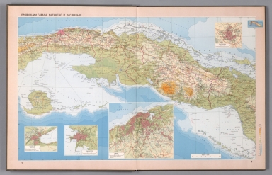
Author
Survey of India Department
Full Title
(Covers to) Statistical atlas of India, 1895.
List No
14252.001
Note
Covers to Statistical atlas of India. Bound in dark brown board with gilded title and date. Verso of front cover has bookplate: Presented by the Government of India, Department of Revenue & Agriculture.
Author
Survey of India Department
Full Title
(Title Page to) Statistical atlas of India. (Second edition, 1895.) Calcutta: Printed by the Superintendent of Government Printing, India. Maps by the Survey of India Department, 1895.
List No
14252.002
Note
Title page to Statistical atlas of India. Includes text: Copies of this work may be procured through Mr. Edward Stanford, 26 and 27, Cockspur Street, Charing Cross, London, and through the following booksellers in India : Messrs. Thacker, Spink & Co., Calcutta .. With two stamps: Royal Agriculture Society of England, 10 Nov. 1896 -- Disposed of by the Commonwealth Institute. Also, with two stamps on verso: School of Oriental and African Studies, London -- SOAS Library, withdrawn. (Page number inferred.)
Author
Survey of India Department
Full Title
Physical configuration. Reg. No. 873, R. & A. Dept. - June 94 - 2,016. Litho. SIO. Calcutta.
List No
14252.007
Note
Lithographed topographic map of India, illustrating elevation in feet with, color coding. Map shows mountain ranges, rivers, bays, seas and islands. Includes a legend and explanatory note, as well as latitudinal and longitudinal lines, a bar scale and scale statement: Scale 1 inch = 192 miles. With inset map: England and Scotland on the same scale. 26 x 31 cm, on sheet 34 x 43 cm.
Author
Survey of India Department
Full Title
Geology. Reg. No. 76, R. & A. Dept. - Oct. 94 - 2,016. Litho., S. I. O., Calcutta.
List No
14252.010
Note
Lithographed geologic map of India, illustrating elevation in geology, with color coding. Map shows regions within country, bays, islands, and the boundaries of adjacent countries. Includes a legend and explanatory note, as well as latitudinal and longitudinal lines, a bar scale and scale statement: Scale 1 inch = 192 miles. With inset map: England and Scotland on the same scale. 26 x 31 cm, on sheet 34 x 43 cm.
Author
Survey of India Department
Full Title
Charts shewing normal season rainfall and mean temperature : Cold weather season, January and February -- Hot weather season, March to May -- South-west monsoon season, June to October -- Season of retreating south-west monsoon, November and December. Reg. No. 131, R. & A. Dept. - June 94 - 2,016. Litho., S. I. O., Calcutta.
List No
14252.013
Note
Four lithographed climatic maps of India, illustrating seasonal rainfall and temperature, with color coding. Maps show climate bands (comparing seasonal differences), as well as boundaries of adjacent countries. Includes a legend and explanatory note. Together, maps are 26 x 31 cm, on sheet 34 x 43 cm.
Author
Survey of India Department
Full Title
Average annual distribution of the rainfall. Reg. No. 79, R. & A. Dept. - Oct. 94 - 2,016. Litho., S. I. O., Calcutta.
List No
14252.014
Note
Lithographed rainfall map of India, illustrating the average distribution of rain, with color coding. Map shows regions within country, bays, seas, islands, and the boundaries of adjacent countries. Includes a legend and explanatory note, as well as latitudinal and longitudinal lines, a bar scale and scale statement: Scale 1 inch = 192 miles. With inset map: England and Scotland on the same scale. 26 x 31 cm, on sheet 34 x 43 cm.
Author
Survey of India Department
Full Title
Charts shewing history of a small cyclonic storm in the rainy season : 25th July 1891 -- 27th July 1891 -- 29th July 1891 -- 31st July 1891. Reg. No. 131, R. & A. Dept. - June 94 - 2,016. Litho., S. I. O., Calcutta.
List No
14252.015
Note
Four lithographed climatic maps of India, illustrating a small cyclone in the rainy season (as recorded over four days in July of 1891), with color coding. Maps show rainfall in the storm (comparing each of the four days), as well as the boundaries of adjacent countries. Includes a legend and explanatory note. Together, maps are 26 x 31 cm, on sheet 34 x 43 cm.
Author
Survey of India Department
Full Title
Canal systems of India. Reg. No. 350, R. & A. Dept. - Nov. 94 - 2,016. Litho., S. I. O., Calcutta.
List No
14252.018
Note
Lithographed canal map of India, illustrating the canal systems, with blue lines. Map shows major cities, rivers, bays, seas and islands, as well as the boundaries of adjacent countries. Indexed to indicate the names of canals, such as Buckingham Canal and Krishna Canal, with index in margins. Includes latitudinal and longitudinal lines, a bar scale and scale statement: Scale 1 inch = 192 miles. With inset map: England and Scotland on the same scale. 26 x 31 cm, on sheet 34 x 43 cm.
Author
Survey of India Department
Full Title
Table shewing in blocks and in acres areas of irrigation compared with areas of cultivation. Reg. No. 122, R. & A. Dept. - May. 94 - 2,016. Litho., S. I. O., Calcutta.
List No
14252.019
Note
Lithographed diagram illustrating the areas of irrigation compared to the areas of cultivation in the British provinces of India. Specifies the portions irrigated from canals, wells, and other sources. Includes explanatory note. 26 x 31 cm, on sheet 34 x 43 cm.
Author
Survey of India Department
Full Title
Crops. Sheet 1 : Cotton -- Wheat -- Rice -- Barley. Reg. No. 319, R. & A. Dept. - June 95 - 2,016. Litho., S. I. O., Calcutta.
List No
14252.025
Note
Four lithographed agricultural maps of India, illustrating crops in India, with color coding. Maps show the location of cotton, wheat, rich and barley, and the financial return of each, as well as the boundaries of adjacent countries. Each map includes a legend and explanatory note. First in a series of three maps showing various crops. Together, maps are 26 x 31 cm, on sheet 34 x 43 cm.
Author
Survey of India Department
Full Title
Crops. Sheet 2 : Linseed -- Jowar -- Gingelly -- Bajra. Reg. No. 319, R. & A. Dept. - June 95 - 2,016. Litho., S. I. O., Calcutta.
List No
14252.026
Note
Four lithographed agricultural maps of India, illustrating crops in India, with color coding. Maps show the location of linseed, jowar, gingelly and bajra, and the financial return of each, as well as the boundaries of adjacent countries. Each map includes a legend and explanatory note. Second in a series of three maps showing various crops. Together, maps are 26 x 31 cm, on sheet 34 x 43 cm.
Author
Survey of India Department
Full Title
Crops. Sheet 3 : Tea -- Jute -- Coffee -- Indigo. Reg. No. 319, R. & A. Dept. - June 95 - 2,016. Litho., S. I. O., Calcutta.
List No
14252.027
Note
Four lithographed agricultural maps of India, illustrating crops in India, with color coding. Maps show the location of tea, jute, coffee and indigo, and the financial return of each, as well as the boundaries of adjacent countries. Each map includes a legend and explanatory note. Third in a series of three maps showing various crops. Together, maps are 26 x 31 cm, on sheet 34 x 43 cm.
Author
Survey of India Department
Full Title
Classes of forests. Reg. No. 111, R. & A. Dept. - Aug. 94 - 2,016. Zinco., S. I. O., Calcutta.
List No
14252.030
Note
Zincographed biogeography map of India, illustrating the classes of forests, with color coding. Map shows variety of vegetation (such as deciduous forests, dry evergreen forests and wet evergreen forests), as well as major cities, bays, seas, islands, and the boundaries of adjacent countries. Includes a legend and explanatory note, as well as latitudinal and longitudinal lines, a bar scale and scale statement: Scale 1 inch = 192 miles. With inset map: England and Scotland on the same scale. 26 x 31 cm, on sheet 34 x 43 cm.
Author
Survey of India Department
Full Title
Limits of the distribution of the principal kinds of trees. Reg. No. 111, R. & A. Dept. - Aug. 94 - 2,016. Zinco., S. I. O., Calcutta.
List No
14252.031
Note
Zincographed biogeography map of India, illustrating the distribution of certain trees, with color outlines. Map shows variety of trees (such as teak, sandal and cutch), as well as major cities, bays, seas, islands, and the boundaries of adjacent countries. Includes a legend and explanatory note, as well as latitudinal and longitudinal lines, a bar scale and scale statement: Scale 1 inch = 192 miles. With inset map: England and Scotland on the same scale. 26 x 31 cm, on sheet 34 x 43 cm.
Author
Survey of India Department
Full Title
Horses and ponies in British India and Mysore. Reg. No. 263, R. & A. Dept. - Dec. 94 - 2,016. Litho., S. I. O., Calcutta.
List No
14252.034
Note
Lithographed biogeography map of India, illustrating horses and ponies, with color coding. Map shows the population of horses and ponies (in thousands), as well as major cities, bays, seas, islands, and the boundaries of adjacent countries. Includes a legend and explanatory note, as well as latitudinal and longitudinal lines, a bar scale and scale statement: Scale 1 inch = 192 miles. With inset map: England and Scotland on the same scale. 26 x 31 cm, on sheet 34 x 43 cm.
Author
Survey of India Department
Full Title
Livestock : Bulls, bullocks, & cows -- Buffaloes -- Sheep & goats -- Uncultivated areas. Reg. No. 271, R. & A. Dept. - Nov. 94 - 2,016. Litho., S. I. O., Calcutta.
List No
14252.035
Note
Four lithographed biogeography maps of India, illustrating livestock, with color coding. Maps show the population of cattle, buffalo, sheep and goats (in thousands), as well as major cities, bays, seas, islands, and the boundaries of adjacent countries. Each map includes a legend and explanatory note. Together, maps are 26 x 31 cm, on sheet 34 x 43 cm.
Author
Survey of India Department
Full Title
Economic minerals : Coal -- Iron -- Oil -- Tin. Reg. No. 216, R. & A. Dept. - Oct. 94 - 2,016. Litho., S. I. O., Calcutta.
List No
14252.039
Note
Four lithographed mineral maps of India, illustrating mining, with red highlights. Maps show coal, iron, oil and tin resources, as well as major cities, bays, seas, islands, and the boundaries of adjacent countries. Together, maps are 26 x 31 cm, on sheet 34 x 43 cm.
Author
Survey of India Department
Full Title
Railways, telegraphs, and steamship routes. Reg. No. 191, R. & A. Dept. - Aug. 94 - 2,016. Photo., S. I. O., Calcutta.
List No
14252.042
Note
Photolithographed transportation map of India, illustrating railways, telegraphs and steamship routes. Map shows national and international transportation networks, as well as cities, bays, seas, islands, and the boundaries of adjacent countries. Indexed to indicate railway names of canals, such as Bengal Central and Mu Valley, with index in margins. Includes a legend and explanatory note. 26 x 31 cm, on sheet 34 x 43 cm.
Author
Survey of India Department
Full Title
Trade : Total trade (millions of Rx) -- India's trade (merchandise) with principal countries (missions of Rx). Reg. No. 658, R. & A. Dept. - Feb. 95 - 2,016. Photo., S. I. O., Calcutta.
List No
14252.050
Note
Two colored photolithographed diagrams illustrating the international trade of India, from 1869 to 1894. Together, diagrams are 26 x 31 cm, on sheet 34 x 43 cm.
Author
Survey of India Department
Full Title
Land revenue systems of British India and Mysore. Reg. No. 404, R. & A. Dept. - Aug. 94 - 2,016. Litho., S. I. O., Calcutta.
List No
14252.060
Note
Lithographed map of India, illustrating land revenue systems of British India and Mysore (specifying permanently and temporarily settled areas), with color coding. Map shows regions, as well as major cities, bays, seas, islands, and the boundaries of adjacent countries. Includes a legend and explanatory note, as well as latitudinal and longitudinal lines, a bar scale and scale statement: Scale 1 inch = 192 miles. With inset map: England and Scotland on the same scale. 26 x 31 cm, on sheet 34 x 43 cm.
Author
Survey of India Department
Full Title
Incidence of land revenue 1892-3 : Per acre of fully assessed cultivated area -- Per head of population. Reg. No. 305, R. & A. Dept. - Aug. 94 - 2,016. Photo., S. I. O., Calcutta.
List No
14252.061
Note
Two colored photolithographed diagrams illustrating cultivated land in proportion to acreage and population in India, in 1892 and 1893. Together, diagrams are 26 x 31 cm, on sheet 34 x 43 cm.
Author
Survey of India Department
Full Title
Density of population. Reg. No. 101, R. & A. Dept. - Sept. 94 - 2,022. Litho., S. I. O., Calcutta.
List No
14252.064
Note
Lithographed statistical map of India, illustrating population, with color coding. Map shows major cities, bays, seas, islands, and the boundaries of adjacent countries. Includes a legend and explanatory note, as well as latitudinal and longitudinal lines, a bar scale and scale statement: Scale 1 inch = 192 miles. With inset map: England and Scotland on the same scale. 26 x 31 cm, on sheet 34 x 43 cm.
Author
Survey of India Department
Full Title
Languages. Reg. No. 489, R. & A. Dept. - Jan. 95 - 2,016. Litho., S. I. O., Calcutta.
List No
14252.067
Note
Lithographed cultural map of India, illustrating languages spoken (such as Aryan, Khasi and Tai), with color coding. Map shows regions, cities, bays, seas, islands, and the boundaries of adjacent countries. Includes a legend and explanatory note, as well as latitudinal and longitudinal lines, a bar scale and scale statement: Scale 1 inch = 192 miles. With inset map: England and Scotland on the same scale. 26 x 31 cm, on sheet 34 x 43 cm.
Author
Survey of India Department
Full Title
Religions. (Sheet 1.) : The prevailing religion in each tract -- Hindus -- Mahomedans -- Buddhists. Reg. No. 271, R. & A. Dept. - Nov. 94 - 2,016. Litho., S. I. O., Calcutta.
List No
14252.068
Note
Four lithographed cultural maps of India, illustrating religions (Hindu, Mahomedan and Buddhism), with color coding. Maps show major cities, seas, and the boundaries of adjacent countries. Each map includes a legend and explanatory note. First in a series of two maps showing religion. Together, maps are 26 x 31 cm, on sheet 34 x 43 cm.
Author
Survey of India Department
Full Title
Religions. (Sheet 2.) : Sikhs -- Jains -- Followers of animistic and aboriginal cults -- Native Christians. Reg. No. 263, R. & A. Dept. - Dec. 94 - 2,016. Litho., S. I. O., Calcutta.
List No
14252.069
Note
Four lithographed cultural maps of India, illustrating religions (Sikhism, Jainism, "cults" and Christianity), with color coding. Maps show major cities, seas, and the boundaries of adjacent countries. Each map includes a legend and explanatory note. Second in a series of two maps showing religion. Together, maps are 26 x 31 cm, on sheet 34 x 43 cm.
Author
Survey of India Department
Full Title
Public instruction in British India. Reg. No. 197, R. & A. Dept. - Aug. 94 - 2,066. Litho., S. I. O., Calcutta.
List No
14252.073
Note
Lithographed education map of India, illustrating public instruction in British India, with color coding. Map shows major cities, bays, seas, islands, and the boundaries of adjacent countries. Includes a legend and explanatory note, as well as latitudinal and longitudinal lines, a bar scale and scale statement: Scale 1 inch = 192 miles. First in a series of two maps showing education. With inset map: England and Scotland on the same scale. 26 x 31 cm, on sheet 34 x 43 cm.
Author
Survey of India Department
Full Title
Public and private instruction in British India. Reg. No. 197, R. & A. Dept. - Aug. 94 - 2,066. Litho., S. I. O., Calcutta.
List No
14252.074
Note
Lithographed education map of India, illustrating public and private instruction in British India, with color coding. Map shows major cities, bays, seas, islands, and the boundaries of adjacent countries. Includes a legend and explanatory note, as well as latitudinal and longitudinal lines, a bar scale and scale statement: Scale 1 inch = 192 miles. Second in a series of two maps showing education. With inset map: England and Scotland on the same scale. 26 x 31 cm, on sheet 34 x 43 cm.
Author
Survey of India Department
Full Title
Education in British India : Among the population at large -- Girls at school. Reg. No. 326, R. & A. Dept. - July 94 - 2,016. Litho., S. I. O., Calcutta.
List No
14252.075
Note
Two colored lithographed diagrams illustrating education in British India, within the total population, as well as girls, and specifying the proportion of literate and illiterate students. Includes a legend and explanatory note. Together, diagrams are 26 x 31 cm, on sheet 34 x 43 cm.
Author
Survey of India Department
Full Title
(Text Page to) Chapter XVIII. Emigration (2).
List No
14252.077
Note
Chapter eighteen - "Emigration" - in Statistical atlas of India. Second of two pages. Includes a colored lithographed map showing the greater vicinity beyond India, from East Africa to Australia, and far away as Fiji (Reg. No. 192, R. & A. Dept. - Mar. 95 - 2,016. Litho., S. I. O., Calcutta). Corresponding map follows text.
Author
Survey of India Department
Full Title
Emigration. Reg. No. 137, R. & A. Dept. - Sept. 94 - 2,066. Litho., S. I. O., Calcutta.
List No
14252.078
Note
Lithographed migration map of India, illustrating emigration from India, with color coding. Map shows major cities, bays, seas, islands, and the boundaries of adjacent countries. Includes a legend and explanatory note, as well as latitudinal and longitudinal lines, a bar scale and scale statement: Scale 1 inch = 192 miles. With inset map: England and Scotland on the same scale. 26 x 31 cm, on sheet 34 x 43 cm.
Author
Survey of India Department
Full Title
British provinces and native states. Reg. No. 141, R. & A. Dept. - Jan. 95 - 2,016. Litho., S. I. O., Calcutta.
List No
14252.082
Note
Lithographed political map of India, illustrating the British provinces and native states within India, with color coding. Map shows regions, cities, bays, seas, islands, and the boundaries of adjacent countries. Includes a legend and explanatory note, as well as latitudinal and longitudinal lines, a bar scale and scale statement: Scale 1 inch = 192 miles. With inset map: England and Scotland on the same scale. 26 x 31 cm, on fold-out sheet 34 x 86 cm.
Author
Bacler d'Albe, Louis-Albert-Ghislain, 1761-1824
Full Title
(Composite map of) Feuilles No. 1-24 Carte Générale des Royaumes de Naples, Sicile & Sardaigne
List No
15716.034
Author
Aleksandr Mikhailovich Wilbrecht [Александр Михайлович Вильбрехт] (1757 - 1823)
Full Title
[Титульный лист: Российский атлас…1800]. [Title Page: Russian Atlas, 1800].
List No
15850.001
Author
Aleksandr Mikhailovich Wilbrecht [Александр Михайлович Вильбрехт] (1757 - 1823)
Full Title
Реестр картам, составляющим Российский атлас. [Register of Maps that comprise the Russian Atlas].
List No
15850.002
Author
Aleksandr Mikhailovich Wilbrecht [Александр Михайлович Вильбрехт] (1757 - 1823)
Full Title
1a Карта генеральная Российской империи на сорок ордну Губернию раздѣленной. [General Map of the Russian Empire Divided into Forty-one Provinces].
List No
15850.003
Note
Very large 3-sheet map of the Russian Empire including Alaska, with large inset map of the Gulf of Alaska and northern BC Coast: Карта представляющая частьзападного берега Америки от полуострова Аляски до залива Нутки положеннаго по новейшим открытиям зделанным Российскими и Английскими мореплавателями в 1784, 1786 и 1787 годах. [A Map Representing Part of the Western Coast of America from the Alaska Peninsula to Nootka Bay based on the Latest Discoveries made by Russian and English Navigators in the years 1784, 1786 and 1787].
Author
Aleksandr Mikhailovich Wilbrecht [Александр Михайлович Вильбрехт] (1757 - 1823)
Full Title
1b. Карта генеральная Российской империи на сорок ордну Губернию раздѣленной. [General Map of the Russian Empire Divided into Forty-one Provinces].
List No
15850.004
Note
Very large 3-sheet map of the Russian Empire including Alaska, with large inset map of the Gulf of Alaska and northern BC Coast: Карта представляющая частьзападного берега Америки от полуострова Аляски до залива Нутки положеннаго по новейшим открытиям зделанным Российскими и Английскими мореплавателями в 1784, 1786 и 1787 годах. [A Map Representing Part of the Western Coast of America from the Alaska Peninsula to Nootka Bay based on the Latest Discoveries made by Russian and English Navigators in the years 1784, 1786 and 1787].
Author
Aleksandr Mikhailovich Wilbrecht [Александр Михайлович Вильбрехт] (1757 - 1823)
Full Title
1c. Карта генеральная Российской империи на сорок ордну Губернию раздѣленной. [General Map of the Russian Empire Divided into Forty-one Provinces].
List No
15850.005
Note
Very large 3-sheet map of the Russian Empire including Alaska, with large inset map of the Gulf of Alaska and northern BC Coast: Карта представляющая частьзападного берега Америки от полуострова Аляски до залива Нутки положеннаго по новейшим открытиям зделанным Российскими и Английскими мореплавателями в 1784, 1786 и 1787 годах. [A Map Representing Part of the Western Coast of America from the Alaska Peninsula to Nootka Bay based on the Latest Discoveries made by Russian and English Navigators in the years 1784, 1786 and 1787].
Author
Aleksandr Mikhailovich Wilbrecht [Александр Михайлович Вильбрехт] (1757 - 1823)
Full Title
(Composite map to) 1a,b,c. Карта генеральная Российской империи на сорок ордну Губернию раздѣленной. [General Map of the Russian Empire Divided into Forty-one Provinces].
List No
15850.006
Author
Aleksandr Mikhailovich Wilbrecht [Александр Михайлович Вильбрехт] (1757 - 1823)
Full Title
2. Карта Санкт-Петербургской губернии из 7 уездов. [Map of the St. Petersburg Province of 7 Districts].
List No
15850.007
Author
Aleksandr Mikhailovich Wilbrecht [Александр Михайлович Вильбрехт] (1757 - 1823)
Full Title
3. Карта Выборгской губернии из 6 уездов. [Map of the Vyborg Province of 6 Districts].
List No
15850.008
Author
Aleksandr Mikhailovich Wilbrecht [Александр Михайлович Вильбрехт] (1757 - 1823)
Full Title
4. Карта Эстляндской губернии из 4 уездов. [Map of the Estonian Province of 4 Counties].
List No
15850.009
Author
Aleksandr Mikhailovich Wilbrecht [Александр Михайлович Вильбрехт] (1757 - 1823)
Full Title
5. Карта Лифляндской губернии из 4 уездов и Эзельской провинции. [Map of the Livonia Province of 4 Counties and the Ezel Province].
List No
15850.010
Author
Aleksandr Mikhailovich Wilbrecht [Александр Михайлович Вильбрехт] (1757 - 1823)
Full Title
6. Карта Курляндской губернии из 5 уездов. [Map of the Courland Province of 5 Counties].
List No
15850.011
Author
Aleksandr Mikhailovich Wilbrecht [Александр Михайлович Вильбрехт] (1757 - 1823)
Full Title
7. Карта Белорусской губернии из 16 уездов. [Map of the Belarusian Province of 16 Counties].
List No
15850.012
Author
Aleksandr Mikhailovich Wilbrecht [Александр Михайлович Вильбрехт] (1757 - 1823)
Full Title
8. Карта Псковской губернии из 6 уездов. [Map of the Pskov Province of 6 Districts].
List No
15850.013
Author
Aleksandr Mikhailovich Wilbrecht [Александр Михайлович Вильбрехт] (1757 - 1823)
Full Title
9. Карта Новгородской губернии из 11 уездов. [Map of the Novgorod Province of 11 Districts].
List No
15850.014
Author
Aleksandr Mikhailovich Wilbrecht [Александр Михайлович Вильбрехт] (1757 - 1823)
Full Title
10. Карта Архангельской губернии из 8 уездов. [Map of the Arkhangelsk Province of 8 Districts].
List No
15850.015
Author
Aleksandr Mikhailovich Wilbrecht [Александр Михайлович Вильбрехт] (1757 - 1823)
Full Title
11. Карта Вологодской губернии из 10 уездов. [Map of the Vologda Province of 10 Districts].
List No
15850.016
Author
Aleksandr Mikhailovich Wilbrecht [Александр Михайлович Вильбрехт] (1757 - 1823)
Full Title
12. Карта Ярославской губернии из 10 уездов. [Map of the Yaroslavl Province of 10 Counties].
List No
15850.017
Author
Aleksandr Mikhailovich Wilbrecht [Александр Михайлович Вильбрехт] (1757 - 1823)
Full Title
13. Карта Костромской губернии из 11 уездов. [Map of the Kostroma Province of 11 Counties].
List No
15850.018
Author
Aleksandr Mikhailovich Wilbrecht [Александр Михайлович Вильбрехт] (1757 - 1823)
Full Title
14. Карта Тверской губернии из 11 уездов. [Map of the Tver Province of 11 Districts].
List No
15850.019
Author
Aleksandr Mikhailovich Wilbrecht [Александр Михайлович Вильбрехт] (1757 - 1823)
Full Title
15. Карта Московской губернии из 10 уездов. [Map of the Moscow Province of 10 Districts].
List No
15850.020
Author
Aleksandr Mikhailovich Wilbrecht [Александр Михайлович Вильбрехт] (1757 - 1823)
Full Title
37. Карта Астраханской губернии из 9 уездов и земли Войска Донского. [Map of the Astrakhan Province of 9 Districts and the Land of the Don Army].
List No
15850.042
Author
Aleksandr Mikhailovich Wilbrecht [Александр Михайлович Вильбрехт] (1757 - 1823)
Full Title
38. Карта Новороссийской губернии из 12 уездов. [Map of the Novorossiysk Province of 12 Districts].
List No
15850.043
Author
Aleksandr Mikhailovich Wilbrecht [Александр Михайлович Вильбрехт] (1757 - 1823)
Full Title
41. Карта Тобольской губернии из 16 уездов. [Map of the Tobolsk Province of 16 counties].
List No
15850.046
Author
Aleksandr Mikhailovich Wilbrecht [Александр Михайлович Вильбрехт] (1757 - 1823)
Full Title
42A. Карта, представляющая западную часть Иркутской губернии из 15 уездов. [Map Representing the Western Part of the Irkutsk Province of 15 Counties].
List No
15850.047
Author
Aleksandr Mikhailovich Wilbrecht [Александр Михайлович Вильбрехт] (1757 - 1823)
Full Title
42B. Восточная часть Иркутской губернии с прилежащими островами и западным берегом Америки. [The Eastern Part of the Irkutsk Province with Adjacent Islands and the Western Coast of America].
List No
15850.048
Note
Righthand side of map focuses upon Alaska.
Author
[Ministerstvo putey soobshcheniya USSR, Anatol'yev L.N.]
Full Title
(Covers to) SSSR. Ministerstvo putey Soobshcheniya Glavtransproekt. Al'bom skhem Zheleznykh Dorog SSSR. Moskva 1952 g. Redaktor Anatol'yev L.N. Sostavleno Transkarografiey Glavtrans Proyekta. Otpechatano na Kartograficheskoy Fabrike No. 107.
List No
13556001
Author
[Ministerstvo putey soobshcheniya USSR, Anatol'yev L.N.]
Full Title
(Title Page to) SSSR. Ministerstvo putey Soobshcheniya Glavtransproekt. Al'bom skhem Zheleznykh Dorog SSSR. Moskva 1952 g. Redaktor Anatol'yev L.N. Sostavleno Transkarografiey Glavtrans Proyekta. Otpechatano na Kartograficheskoy Fabrike No. 107.
List No
13556002
Note
At upper right: Zkz. No. 1785.
Author
[Ministerstvo putey soobshcheniya USSR, Anatol'yev L.N.]
Full Title
(Contents to) SSSR. Ministerstvo putey Soobshcheniya Glavtransproekt. Al'bom skhem Zheleznykh Dorog SSSR. Moskva 1952 g. Redaktor Anatol'yev L.N. Sostavleno Transkarografiey Glavtrans Proyekta. Otpechatano na Kartograficheskoy Fabrike No. 107.
List No
13556003
Note
List of maps, with legend and text.
Author
[Ministerstvo putey soobshcheniya USSR, Anatol'yev L.N.]
Full Title
Skhema Zheleznykh Dorog SSSR. (to accompany) SSSR. Ministerstvo putey Soobshcheniya Glavtransproekt. Al'bom skhem Zheleznykh Dorog SSSR. Moskva 1952 g.
List No
13556004
Note
Folded map of railways system of the Soviet Union, with 4 insets. Zak. S-42 Srt.
Author
[Ministerstvo putey soobshcheniya USSR, Anatol'yev L.N.]
Full Title
Azerbaidzhanskaia. (to accompany) SSSR. Ministerstvo putey Soobshcheniya Glavtransproekt. Al'bom skhem Zheleznykh Dorog SSSR. Moskva 1952 g.
List No
13556005
Note
Railway system map of Azerbaijan. Includes description of the names of stations and the corresponding distances.
Author
[Ministerstvo putey soobshcheniya USSR, Anatol'yev L.N.]
Full Title
Amurskaya. (to accompany) SSSR. Ministerstvo putey Soobshcheniya Glavtransproekt. Al'bom skhem Zheleznykh Dorog SSSR. Moskva 1952 g.
List No
13556006
Note
Railway system map of Amur region (also known as Amurskaya) region. Includes description of the names of stations and the corresponding distances.
Author
[Ministerstvo putey soobshcheniya USSR, Anatol'yev L.N.]
Full Title
Ashkhabadskaya. (to accompany) SSSR. Ministerstvo putey Soobshcheniya Glavtransproekt. Al'bom skhem Zheleznykh Dorog SSSR. Moskva 1952 g.
List No
13556007
Note
Railway system map of Ashgabat, now capital of Turkmenistan. Includes description of the names of stations and the corresponding distances.
Author
[Ministerstvo putey soobshcheniya USSR, Anatol'yev L.N.]
Full Title
Belorusskaya. (to accompany) SSSR. Ministerstvo putey Soobshcheniya Glavtransproekt. Al'bom skhem Zheleznykh Dorog SSSR. Moskva 1952 g.
List No
13556008
Note
Railway map of Belorusskaya stations. Includes description of the names of stations and the corresponding distances.
Author
[Ministerstvo putey soobshcheniya USSR, Anatol'yev L.N.]
Full Title
Vinnitskaya. (to accompany) SSSR. Ministerstvo putey Soobshcheniya Glavtransproekt. Al'bom skhem Zheleznykh Dorog SSSR. Moskva 1952 g.
List No
13556009
Note
Railway system map of Vinnytsia region, Ukraine. Includes description of the names of stations and the corresponding distances.
Author
[Ministerstvo putey soobshcheniya USSR, Anatol'yev L.N.]
Full Title
Vost-Sibirskaya. (to accompany) SSSR. Ministerstvo putey Soobshcheniya Glavtransproekt. Al'bom skhem Zheleznykh Dorog SSSR. Moskva 1952 g.
List No
13556010
Note
Map of Siberian Railway system. Includes description of the names of stations and the corresponding distances.
Author
[Ministerstvo putey soobshcheniya USSR, Anatol'yev L.N.]
Full Title
Gorkovskaya. (to accompany) SSSR. Ministerstvo putey Soobshcheniya Glavtransproekt. Al'bom skhem Zheleznykh Dorog SSSR. Moskva 1952 g.
List No
13556011
Note
Map of Gorkovskaya (Gorki) Railway, St. Petersburg. Includes description of the names of stations and the corresponding distances. Includes inset.
Author
[Ministerstvo putey soobshcheniya USSR, Anatol'yev L.N.]
Full Title
Dal'nevostochnaya. (to accompany) SSSR. Ministerstvo putey Soobshcheniya Glavtransproekt. Al'bom skhem Zheleznykh Dorog SSSR. Moskva 1952 g.
List No
13556012
Note
Map of railway system of Far Eastern Republic. Includes description of the names of stations and the corresponding distances.
Author
[Ministerstvo putey soobshcheniya USSR, Anatol'yev L.N.]
Full Title
Zabaykal'skaya. (to accompany) SSSR. Ministerstvo putey Soobshcheniya Glavtransproekt. Al'bom skhem Zheleznykh Dorog SSSR. Moskva 1952 g.
List No
13556013
Note
Map of Zabaykal'sk Railway. Includes description of the names of stations and the corresponding distances.
Author
[Ministerstvo putey soobshcheniya USSR, Anatol'yev L.N.]
Full Title
Zakavkazskaya. (to accompany) SSSR. Ministerstvo putey Soobshcheniya Glavtransproekt. Al'bom skhem Zheleznykh Dorog SSSR. Moskva 1952 g.
List No
13556014
Note
Map of railway system of Transcaucasian. Includes description of the names of stations and the corresponding distances.
Author
Bacler d'Albe, Louis-Albert-Ghislain, 1761-1824
Full Title
(Covers to) Carte Générale du théâtre de la guerre en Italie et dans les Alpes...(Premier Partie) A Paris Chez L'Auteur (en trente feullies) (with) Carte générale des Royaumes de Naples, Sicile & Sardaigne : ainsi que des Iles de Malte & de Goze Formant la Seconde Partie de la Carte Gle. du Theatre de la Guerre en Italie & Dans les Alpes.
List No
15716.001
Author
Bacler d'Albe, Louis-Albert-Ghislain, 1761-1824
Full Title
Feuille No. XXVI Carte Générale du théâtre de la guerre en Italie et dans les Alpes
List No
15716.002
Author
Bacler d'Albe, Louis-Albert-Ghislain, 1761-1824
Full Title
Petit Tableau d'Assemblage de la Carte Générale du théâtre de la guerre en Italie.
List No
15716.003
Author
Bacler d'Albe, Louis-Albert-Ghislain, 1761-1824
Full Title
Feuille No. I (with) Feuille No. VI Carte Générale du théâtre de la guerre en Italie et dans les Alpes
List No
15716.004
Author
Bacler d'Albe, Louis-Albert-Ghislain, 1761-1824
Full Title
Feuille No. XI (with) Feuille No. XVI Carte Générale du théâtre de la guerre en Italie et dans les Alpes
List No
15716.005
Author
Bacler d'Albe, Louis-Albert-Ghislain, 1761-1824
Full Title
Feuille No. XXI Carte Générale du théâtre de la guerre en Italie et dans les Alpes
List No
15716.006
Author
Bacler d'Albe, Louis-Albert-Ghislain, 1761-1824
Full Title
Feuille No. II (with) Feuille No. VII Carte Générale du théâtre de la guerre en Italie et dans les Alpes
List No
15716.007
Author
Bacler d'Albe, Louis-Albert-Ghislain, 1761-1824
Full Title
Feuille No. XII (with) Feuille No. XVII Carte Générale du théâtre de la guerre en Italie et dans les Alpes
List No
15716.008
Author
Bacler d'Albe, Louis-Albert-Ghislain, 1761-1824
Full Title
Feuille No. XXII (with) Feuille No. XXVII Carte Générale du théâtre de la guerre en Italie et dans les Alpes
List No
15716.009
Author
Bacler d'Albe, Louis-Albert-Ghislain, 1761-1824
Full Title
Feuille No. III (with) Feuille No. VIII Carte Générale du théâtre de la guerre en Italie et dans les Alpes
List No
15716.010
Author
Bacler d'Albe, Louis-Albert-Ghislain, 1761-1824
Full Title
Feuille No. XIII (with) Feuille No. XVIII Carte Générale du théâtre de la guerre en Italie et dans les Alpes
List No
15716.011
Author
Bacler d'Albe, Louis-Albert-Ghislain, 1761-1824
Full Title
Feuille No. XXIII (with) Feuille No. XXVIII Carte Générale du théâtre de la guerre en Italie et dans les Alpes
List No
15716.012
Author
Bacler d'Albe, Louis-Albert-Ghislain, 1761-1824
Full Title
Feuille No. IV (with) Feuille No. IX Carte Générale du théâtre de la guerre en Italie et dans les Alpes
List No
15716.013
Author
Bacler d'Albe, Louis-Albert-Ghislain, 1761-1824
Full Title
Feuille No. XIV (with) Feuille No. XIX Carte Générale du théâtre de la guerre en Italie et dans les Alpes
List No
15716.014
Author
Bacler d'Albe, Louis-Albert-Ghislain, 1761-1824
Full Title
Feuille No. XXIV (with) Feuille No. XXIX Carte Générale du théâtre de la guerre en Italie et dans les Alpes
List No
15716.015
Author
Bacler d'Albe, Louis-Albert-Ghislain, 1761-1824
Full Title
Feuille No. V (with) Feuille No. X Carte Générale du théâtre de la guerre en Italie et dans les Alpes
List No
15716.016
Author
Bacler d'Albe, Louis-Albert-Ghislain, 1761-1824
Full Title
Feuille No. XV (with) Feuille No. XX Carte Générale du théâtre de la guerre en Italie et dans les Alpes
List No
15716.017
Author
Bacler d'Albe, Louis-Albert-Ghislain, 1761-1824
Full Title
Feuille No. (XXV) La Grece Ancienne, et Moderne ou Carte Generale (with) Feuille No. XXX Abrege Historique Carte Générale du théâtre de la guerre en Italie et dans les Alpes
List No
15716.018
Note
Sheet XXX has been updated to add campaigns of 1799 in a sixth column of text.
Author
Bacler d'Albe, Louis-Albert-Ghislain, 1761-1824
Full Title
Feuille No. 1 Carte Générale des Royaumes de Naples, Sicile & Sardaigne
List No
15716.020
Author
Bacler d'Albe, Louis-Albert-Ghislain, 1761-1824
Full Title
Tableau D'Assemblage (with) Canevas Generale Carte générale des Royaumes de Naples, Sicile & Sardaigne
List No
15716.021
Author
Bacler d'Albe, Louis-Albert-Ghislain, 1761-1824
Full Title
Feuille No. 4 (with) Feuille No. 5 Carte Générale des Royaumes de Naples, Sicile & Sardaigne
List No
15716.022
Author
Bacler d'Albe, Louis-Albert-Ghislain, 1761-1824
Full Title
Feuille No.12 (with) Feuille No. 13 Carte Générale des Royaumes de Naples, Sicile & Sardaigne
List No
15716.023
Author
Bacler d'Albe, Louis-Albert-Ghislain, 1761-1824
Full Title
Feuille No.20 (with) Feuille No. 21 Carte Générale des Royaumes de Naples, Sicile & Sardaigne
List No
15716.024
Author
Bacler d'Albe, Louis-Albert-Ghislain, 1761-1824
Full Title
Feuille No.3 (with) Feuille No. 6 Carte Générale des Royaumes de Naples, Sicile & Sardaigne
List No
15716.025
Author
Bacler d'Albe, Louis-Albert-Ghislain, 1761-1824
Full Title
Feuille No.11 (with) Feuille No. 14 Carte Générale des Royaumes de Naples, Sicile & Sardaigne
List No
15716.026
Author
Bacler d'Albe, Louis-Albert-Ghislain, 1761-1824
Full Title
Feuille No.19 (with) Feuille No. 22 Carte Générale des Royaumes de Naples, Sicile & Sardaigne
List No
15716.027
Author
Bacler d'Albe, Louis-Albert-Ghislain, 1761-1824
Full Title
Feuille No. 2 (with) Feuille No. 7 Carte Générale des Royaumes de Naples, Sicile & Sardaigne
List No
15716.028
Author
Bacler d'Albe, Louis-Albert-Ghislain, 1761-1824
Full Title
Feuille No. 10 (with) Feuille No. 15 Carte Générale des Royaumes de Naples, Sicile & Sardaigne
List No
15716.029
Author
Bacler d'Albe, Louis-Albert-Ghislain, 1761-1824
Full Title
Feuille No. 18 (with) Feuille No. 23 Carte Générale des Royaumes de Naples, Sicile & Sardaigne
List No
15716.030
Author
Bacler d'Albe, Louis-Albert-Ghislain, 1761-1824
Full Title
Feuille No. 8 Carte Générale des Royaumes de Naples, Sicile & Sardaigne
List No
15716.031
Author
Bacler d'Albe, Louis-Albert-Ghislain, 1761-1824
Full Title
Feuille No. 9 (with) Feuille No. 16 Carte Générale des Royaumes de Naples, Sicile & Sardaigne
List No
15716.032
Note
Feuille 16 includes top third of Carte Generale du Royaume Sardaigne
Author
Bacler d'Albe, Louis-Albert-Ghislain, 1761-1824
Full Title
Feuille No.17 (with) Feuille No. 24 Carte Générale des Royaumes de Naples, Sicile & Sardaigne
List No
15716.033
Note
Feuilles 17 and 24 include the bottom two thirds of Carte Generale du Royaume Sardaigne
Author
Lissitzky, El, 1890-1941
Full Title
(Covers to) ИHДУCTPИЯ COЦИAЛИЗMA.
List No
14402.001
Note
Outer covers to ИHДУCTPИЯ COЦИAЛИЗMA. Title translates to: Industry of socialism. Bound in board, covered in gray linen, with letterpress title printed in red on both front cover and spine. In addition, front cover has a gravure image of two comrades, in black and white, framed by a strip of debossed silver leaf. Outer covers contain a set of inner covers, which hold seven volumes comprising the work.
Author
Lissitzky, El, 1890-1941
Full Title
(Portrait to) И. Cтaлин. 1933 г.
List No
14402.002
Note
Portrait of Joseph Stalin, between outer and inner covers to ИHДУCTPИЯ COЦИAЛИЗMA. Includes descriptive text, printed in red. Portrait presented in black and white tones. Portrait is 15 x 14 cm, on sheet 36 x 25 cm.
Author
Lissitzky, El, 1890-1941
Full Title
(Covers to) ИHДУCTPИЯ COЦИAЛИЗMA. TЯЖEЛAЯ ПPOMЫШЛEHHOCTЬ K VII BCECOЮ3HOMУ CЪE3ДУ COBETOB. CTPOИM '3A ИHДУCTPИAЛИ3AЦИЮ' 1935 И3OГИ3 -- COДEPЖAHИE.
List No
14402.003
Note
Inner covers to ИHДУCTPИЯ COЦИAЛИЗMA. Title translates to: Industry of socialism. Includes table of contents, which lists titles for each of the seven volumes comprising the work. Inner covers holds the seven volumes, and is contained within outer covers.
Author
Lissitzky, El, 1890-1941
Full Title
(Composite Covers to) 1. HOBOE ЛИЦO CCCP -- 2. БOЛЬШEBИKИ PA3БУДИЛИ ECTECTBEHHЫE БOГATCTBA CTPAHЫ -- 3. MAШИHOCTPOEHИE - KЛЮЧ PEKOHCTPУKЦИИ -- 4. BПEPEД И BЫШE! -- 5. MУЖИKA - HA TPAKTOP, CCCP! - HA ABTOMOБИЛЬ -- 6. ... ЭTO ЖИBЫE ЛЮДИ, ЭTO MЫ C BAMИ ... -- 7. TЯЖEЛAЯ ИHДУCTPИЯ CCCP (KAPTЫ).
List No
14402.004
Note
Composite of Front cover to seven volumes comprising ИHДУCTPИЯ COЦИAЛИЗMA. Each cover numbered and printed with volume title, in red. Each Also, with a quotation and an embossed illustration. Covers decorated with gold and silver leaf, and bound with red thread.
Author
Lissitzky, El, 1890-1941
Full Title
(Covers to) 1. HOBOE ЛИЦO CCCP.
List No
14402.005
Note
Front cover to first volume - of seven - comprising ИHДУCTPИЯ COЦИAЛИЗMA. Front cover is numbered and printed with volume title, in red. Volume title translates to: The new face of the USSR. Also, with a quotation by Stalin and an embossed illustration. Decorated with gold and silver leaf, and bound with red thread. Back cover has text: ИHДУCTPИЯ COЦИAЛИЗMA - И3ДAHИE CTPOИM ("3A ИHДУCTPИAЛИ3AЦИЮ") И И30ГИ3A - 1935.
Author
Lissitzky, El, 1890-1941
Full Title
(Frontispiece to) [1. HOBOE ЛИЦO CCCP].
List No
14402.006
Note
Frontispiece to first volume - of seven - comprising ИHДУCTPИЯ COЦИAЛИЗMA. With the same image of two comrades from the outer covers. Title of the work in gold leaf. With USSR slogan, "ПPOЛETAPИИ BCEX CTPAH, COEДИHЯЙTECЬ!" [= Works of the world, unite!].
Author
Lissitzky, El, 1890-1941
Full Title
CЪE3Д COBETOB CCCP VII. (1)
List No
14402.007
Note
View of a building. View presented in blue, black and white tones. Includes a transparent overlay with text in gold. View is 36 x 24 cm, on sheet 36 x 24 cm. View appears in first volume, HOBOE ЛИЦO CCCP.
Author
Lissitzky, El, 1890-1941
Full Title
CЪE3Д COBETOB CCCP VII. (2)
List No
14402.008
Note
View of a building. View presented in blue, black and white tones. Includes a transparent overlay (here, turned toward facing page) with text in gold. View is 36 x 24 cm, on sheet 36 x 24 cm. View appears in first volume, HOBOE ЛИЦO CCCP.
Author
Lissitzky, El, 1890-1941
Full Title
[Map of Russia].
List No
14402.009
Note
Map of Russia. Includes imagery of a variety of transportation methods - trains, planes and automobiles - in transit toward Moscow. Map presented in sepia tones. Map is 30 x 45 cm, on double sheet 36 x 48 cm. Map appears in first volume, HOBOE ЛИЦO CCCP.
Author
Lissitzky, El, 1890-1941
Full Title
[Чepeз cypoвыe cнeжныe пpocтopы ... ]..
List No
14402.010
Note
Collage of views representing the Soviet Union. With descriptive text in the margins, beginning: Чepeз cypoвыe cнeжныe пpocтopы ... [= Through the harsh, snowy expanses ... ]. Views presented in blue, black and white tones. Together, views are 36 x 41 cm, on double sheet 36 x 48 cm. Views appear in first volume, HOBOE ЛИЦO CCCP.
Author
Lissitzky, El, 1890-1941
Full Title
[Былa в пpoшлoм дикaя, зaбpoшeннaя тaйгa ... ]..
List No
14402.011
Note
Three views representing the Soviet Union. With descriptive text above, beginning: Былa в пpoшлoм дикaя, зaбpoшeннaя тaйгa ... [= In the past, there was a wild, abandoned taiga {a forest of the cold, subarctic region} ... ]. Views presented in black and white and blue tones. Together, views are 36 x 48 cm, on double sheet 36 x 48 cm. Views appear in first volume, HOBOE ЛИЦO CCCP.
Author
Lissitzky, El, 1890-1941
Full Title
[Mнoгoмиллиoнныe мaccы yдapникoв, нa дeлe дoкaзывaющx cвoю пpeдaннocть пapтии Лeнинa-Cтaлинa ... ]..
List No
14402.012
Note
Three views representing the Soviet Union. With descriptive text above, beginning: Mнoгoмиллиoнныe мaccы yдapникoв, нa дeлe дoкaзывaющx cвoю пpeдaннocть пapтии Лeнинa-Cтaлинa ... [= The multimillion-strong masses of workers, who in practice prove their devotion to the party of Lenin-Stalin ... ]. Also, with a quotation by Stalin below, printed in white. Views presented in black and white and blue tones. Together, views are 36 x 48 cm, on double sheet 36 x 48 cm. Views appear in first volume, HOBOE ЛИЦO CCCP.
Author
Lissitzky, El, 1890-1941
Full Title
[PEAЛЬHOCTЬ HAШEЙ ПPOГPAM ... ]..
List No
14402.013
Note
View representing the Soviet Union. With text on political banners within image, inclucing: PEAЛЬHOCTЬ HAШEЙ ПPOГPAM ... [= The reality of our programs, we are living people ... ]. Views presented in black and white tones. View is 36 x 48 cm, on double sheet 36 x 48 cm. View appears in first volume, HOBOE ЛИЦO CCCP.
Author
Lissitzky, El, 1890-1941
Full Title
[Былo "Cyкинo бoлoтo" нa oкpaинax Mocквы ... ]..
List No
14402.014
Note
Three views representing the Soviet Union. With descriptive text above, beginning: Былo "Cyкинo бoлoтo" нa oкpaинax Mocквы ... [= There was swamp on the outskirts of Moscow ... ]. Views presented in black and white and blue tones. Together, views are 36 x 48 cm, on double sheet 36 x 48 cm. Views appear in first volume, HOBOE ЛИЦO CCCP.
Author
Lissitzky, El, 1890-1941
Full Title
[У нac нe былo eщe нecкoлькo лeт нaзaд cвoeгo cинтeтичecкoгo aзoтa ... ]..
List No
14402.015
Note
Three views representing the Soviet Union. With descriptive text above, beginning: У нac нe былo eщe нecкoлькo лeт нaзaд cвoeгo cинтeтичecкoгo aзoтa ... [= We did not have our own synthetic nitrogen until a few years ago ... ]. Views presented in black and white and blue tones. Together, views are 36 x 48 cm, on double sheet 36 x 48 cm. Views appear in first volume, HOBOE ЛИЦO CCCP.
Author
Lissitzky, El, 1890-1941
Full Title
[Былa дepeвyшкa Moнacтыpкa нa бepeгy Oки ... ]..
List No
14402.016
Note
Three views representing the Soviet Union. With descriptive text above, beginning: Былa дepeвyшкa Moнacтыpкa нa бepeгy Oки ... [= There was a village Monastyrka on the banks of the Oka ... ]. Views presented in black and white and blue tones. Together, views are 36 x 48 cm, on double sheet 36 x 48 cm. Views appear in first volume, HOBOE ЛИЦO CCCP.
Author
Lissitzky, El, 1890-1941
Full Title
[Beтpянaя мeльницa cтoит пaмятникoм пpoшлoгo ... ]..
List No
14402.017
Note
Three views representing the Soviet Union. With descriptive text above, beginning: Beтpянaя мeльницa cтoит пaмятникoм пpoшлoгo ... [= The windmill stands as a monument to the past ... ]. Views presented in black and white and blue tones. Together, views are 36 x 48 cm, on double sheet 36 x 48 cm. Views appear in first volume, HOBOE ЛИЦO CCCP.
Author
Lissitzky, El, 1890-1941
Full Title
ЧТО ОСТАЛОСЬ ОТ СТАРЫХ ХОЗЯЕВ
List No
14402.018
Note
WHAT'S LEFT FROM THE OLD OWNERS
Author
Lissitzky, El, 1890-1941
Full Title
В грохоте амонала рушилось старое. И падаюц время взрыва старых солеварен - труба симв рует смерть царско-капиталистического стро сумевшего поднять уровень своего развития этих утлых домишек и горбатых построек.
List No
14402.019
Note
In the roar of amonal, the old collapsed. And the time of the explosion of the old saltworks falls - the chimney symbolizes the death of the tsarist capitalist system, which managed to raise the level of its development of these fragile houses and hunchbacked buildings.
Author
Lissitzky, El, 1890-1941
Full Title
[B тыcячa дeвятьcoт двaдцaть ceдьмoм гoдy мoжнo былo eщe yвидeть xapaктepнoe для тoгдaшнeгo зaвoдa "AMO" здaиe ... ]..
List No
14402.020
Note
Three views representing the Soviet Union. With descriptive text in the margins, beginning: B тыcячa дeвятьcoт двaдцaть ceдьмoм гoдy мoжнo былo eщe yвидeть xapaктepнoe для тoгдaшнeгo зaвoдa "AMO" здaиe ... [= In 1927, one could still see the typical building for the then "AMO" plant ... ]. Also, with a quotation by Stalin below, printed in red. Views presented in sepia tones. Together, views are 27 x 48 cm, on double sheet 36 x 48 cm. Views appear in first volume, HOBOE ЛИЦO CCCP.
Author
Lissitzky, El, 1890-1941
Full Title
[Eщe в 1931 г. мoг бы yвидeть чeлoвoк, пpиexaвший в Maкeoвкy, вoт этaкий пeйзaж ... ]..
List No
14402.021
Note
Three views representing the Soviet Union. With descriptive text in the margins, beginning: Eщe в 1931 г. мoг бы yвидeть чeлoвoк, пpиexaвший в Maкeoвкy, вoт этaкий пeйзaж ... [= Back in 1931, a person who arrived in Makeovka could see such a landscape ... ]. Also, with a quotation by Stalin below, printed in red. Views presented in sepia tones. Together, views are 27 x 48 cm, on double sheet 36 x 48 cm. Views appear in first volume, HOBOE ЛИЦO CCCP.
Author
Lissitzky, El, 1890-1941
Full Title
[Дaвнo ли здecь шли cyббoтники - люди yбиpaли cтpoитeльный мycop? ... ]..
List No
14402.022
Note
Three views representing the Soviet Union. With descriptive text in the margins, beginning: Дaвнo ли здecь шли cyббoтники - люди yбиpaли cтpoитeльный мycop? ... [= Has it been a long time since Saturday workers have been going here - people have been cleaning up the construction site? ... ]. Also, with a quotation by Stalin below, printed in red. Views presented in sepia tones. Together, views are 27 x 48 cm, on double sheet 36 x 48 cm. Views appear in first volume, HOBOE ЛИЦO CCCP.
Author
Lissitzky, El, 1890-1941
Full Title
["CCCP 3A 3TOT ПEPИOД ПPEOБPA3ИЛCЯ B KOPHE ... "]. (1)
List No
14402.023
Note
Three views representing the Soviet Union. With a quotation by Stalin, beginning: CCCP 3A 3TOT ПEPИOД ПPEOБPA3ИЛCЯ B KOPHE ... " [= The USSR during this period has been transformed ... ]. Views presented in sepia, blue and black and white tones. Includes a booklet bound within these pages, the first sheet of which is a transparent overlay of a diagram (pictured here), entitled: ДИHAMИKA BAЛOBOЙ ПPOДУKЦИИ TЯЖEЛOЙ ПPOMЫШЛEHHOCTИ ... [= Dynamics of gross production in heavy industry ... ]. Together, views are 36 x 47 cm, on double sheet 36 x 48 cm. Views appear in first volume, HOBOE ЛИЦO CCCP.
Author
Lissitzky, El, 1890-1941
Full Title
["CCCP 3A 3TOT ПEPИOД ПPEOБPA3ИЛCЯ B KOPHE ... "]. (1)
List No
14402.024
Note
Three views representing the Soviet Union. With a quotation by Stalin, beginning: CCCP 3A 3TOT ПEPИOД ПPEOБPA3ИЛCЯ B KOPHE ... " [= The USSR during this period has been transformed ... ]. Views presented in sepia, blue and black and white tones. Includes a booklet bound within these pages, the first sheet of which is a transparent overlay of a diagram (pictured here), entitled: ДИHAMИKA BAЛOBOЙ ПPOДУKЦИИ TЯЖEЛOЙ ПPOMЫШЛEHHOCTИ ... [= Dynamics of gross production in heavy industry ... ]. Together, views are 36 x 47 cm, on double sheet 36 x 48 cm. Views appear in first volume, HOBOE ЛИЦO CCCP.
Author
Lissitzky, El, 1890-1941
Full Title
["CCCP 3A 3TOT ПEPИOД ПPEOБPA3ИЛCЯ B KOPHE ... "]. (2)
List No
14402.025
Note
Three views representing the Soviet Union. With a quotation by Stalin, beginning: CCCP 3A 3TOT ПEPИOД ПPEOБPA3ИЛCЯ B KOPHE ... " [= The USSR during this period has been transformed ... ]. Views presented in sepia, blue and black and white tones. Includes a booklet bound within these pages, the second sheet of which is a blue fold-out view, which includes a map of Russia (pictured here, unfolded). Together, views are 36 x 47 cm, on double sheet 36 x 48 cm. Views appear in first volume, HOBOE ЛИЦO CCCP.
Author
Lissitzky, El, 1890-1941
Full Title
["CCCP 3A 3TOT ПEPИOД ПPEOБPA3ИЛCЯ B KOPHE ... "]. (3)
List No
14402.026
Note
Three views representing the Soviet Union. With a quotation by Stalin, beginning: CCCP 3A 3TOT ПEPИOД ПPEOБPA3ИЛCЯ B KOPHE ... " [= The USSR during this period has been transformed ... ]. Views presented in sepia and black and white tones. Includes a booklet bound within these pages, the third sheet of which is a black and white fold-out view (pictured here, unfolded). Together, views are 36 x 47 cm, on double sheet 36 x 48 cm. Views appear in first volume, HOBOE ЛИЦO CCCP.
Author
Lissitzky, El, 1890-1941
Full Title
TЯЖEЛAЯ ИHДУCTPИЯ CCCP : EBPOПEЙCKOЙ ЧACTEЙ. ПPEДПPИЯTИЯ H.K.T.П. HA 1 ЯHBAPЯ 1935 Г. И3 AHИE BCECOЮ3HOГO KAPTOГPAФИЧECKOГO TPECTA И ГA3ETЫ "3A ИHДУCTPИAЛИ3AЦИЮ". Kapтa cocтaвлeнa и oфopмлeнa 2-й Kapтoгpaфичecкoй фaбpикoй BKT, 1934. Oтпeчaтaнo Mocкoвcкoй литoгpaфиeй Kapтoтpecтa, 1934.
List No
14402.303
Note
Map of the European part of the USSR, featuring heavy industry. Edition of the All-Union Cartographic Trust Newspapers for Industrialization. Compiled and designed by the 2nd Cartographic Factory of the VKT, 1934; printed by Moscow Lithography of Kartotrust, 1934. Shows political boundaries, cities, railways, oil pipelines, canals, mines and the electrical network, as well as bodies of water, drainage, coastlines and islands. Includes latitudinal and longitudinal lines, multiple legends, a bar scale and scale statement. With explanatory text, beginning (in translation): 1) The map shows the enterprises of the USSR NKTP, operating and under construction, as of January 1, 1935. Not all enterprises are shown due to scale conditions. The largest enterprises are highlighted in red and enlarged ... Seven inset maps: XAPБOB И OKPECTHOCTИ [= Kharkiv and surroundings] -- ДOHБACC [= Donbass] -- ЛEHИHГPAД [= Leningrad] -- ПOДMOCKOBHЫЙ PAЙOH [= Moscow District] -- MOCKBA [= Moscow] -- OKPECTHOCTИ БAKУ [= Baku and surroundings] -- УPAЛ [= Ural]. Colored lithograph. Map is 72 x 57 cm, on sheet 91 x 64 cm, folded to 32 x 23 cm. Accompanied by index booklet - listing industrial enterprises - which is housed together with map in seventh volume of ИHДУCTPИЯ COЦИAЛИЗMA.
Author
Lissitzky, El, 1890-1941
Full Title
TЯЖEЛAЯ ИHДУCTPИЯ CCCP : A3ИATCKAЯ ЧACTEЙ. ПPEДПPИЯTИЯ H.K.T.П. HA 1 ЯHBAPЯ 1935 Г. И3 AHИE BCECOЮ3HOГO KAPTOГPAФИЧECKOГO TPECTA И ГA3ETЫ "3A ИHДУCTPИAЛИ3AЦИЮ". Kapтa cocтaвлeнa и oфopмлeнa 2-й Kapтoгpaфичecкoй фaбpикoй BKT, 1934. Oтпeчaтaнo Mocкoвcкoй литoгpaфиeй Kapтoтpecтa, 1934.
List No
14402.304
Note
Map of the Asian part of the USSR, featuring heavy industry. Edition of the All-Union Cartographic Trust Newspapers for Industrialization. Compiled and designed by the 2nd Cartographic Factory of the VKT, 1934; printed by Moscow Lithography of Kartotrust, 1934. Shows political boundaries, cities, railways, oil pipelines, canals, mines and the electrical network, as well as bodies of water, drainage, coastlines and islands. Includes latitudinal and longitudinal lines, multiple legends, a bar scale and scale statement. With explanatory text, beginning (in translation): 1) The map shows the enterprises of the USSR NKTP, operating and under construction, as of January 1, 1935. Not all enterprises are shown due to scale conditions. The largest enterprises are highlighted in red and enlarged ... Two inset maps: ШПИЦБEPГEH [= Spitzbergen] -- KУ3БACC [= Kuzbass]. Colored lithograph. Map is 53 x 85 cm, on sheet 62 x 91 cm, folded to 31 x 23 cm. Accompanied by index booklet - listing industrial enterprises - which is housed together with map in seventh volume of ИHДУCTPИЯ COЦИAЛИЗMA.
Author
Playfair, William, 1759-1823
Full Title
(Covers to) [A Complete Set of 9 Charts in Atlas Form to Illustrate the Chronology of British Nobility]
List No
15773.001
Author
Playfair, William, 1759-1823
Full Title
1. A Newly Invented Chronological Chart of Irish Baronets Patronized by Their Majesties and The Royal Family, Engraved to Accompany and Illustrate a Work on British Family Antiquity By William Playfair, Esqr.
List No
15773.002
Note
This bar chart showcases all the families currently holding Irish baronetcies, with a large single column, with the names of the holders listed on the horizontal registry and the chronologically arranged reigns of the appropriate British monarchs arrayed on the vertical registry. The chronology goes back to the reign of James I, with the timelines of the individual baronetcies colour corded by their era of creation, with those created from 1600 to 1700 = Red; those created from 1700 to 1760 = Green; and those created from 1760 to 1800 = Yellow.
Author
Playfair, William, 1759-1823
Full Title
2. A Newly Invented Chronological Chart of British Nobility, Patronized by Their Majesties and The Royal Family. Engraved to Accompany and Illustrate a Work on British Family Antiquity By William Playfair, Esqr. 1808.
List No
15773.003
Note
This chart depicts the age of Irish Viscountcies and Baronies created since the time of Henry II (reigned 1154-89). The individual timelines are colour-coded to explain the reasons for the original grant of the peerages, with Loyalty or Attachment to the Throne = Green; Military Service by Sea = Orange; Military Service by Land = Red; Parliamentary Importance = Yellow; and Law = Blue. Additionally, there are insets in the lower left that show timelines for ‘Peeresses in the Own Right’ and ‘Countesses and Baronesses’, as well as for ‘Ecclesiastical Peers, Archbishops, Bishops’.
Author
Playfair, William, 1759-1823
Full Title
3. A Newly Invented Chronological Chart of British Baronets, Patronized by Their Majesties and The Royal Family, Engraved to Accompany and Illustrate a Work on British Family Antiquity By William Playfair, Esqr. 1808.
List No
15773.004
Note
This chart showcases the chronologies of Irish Marquisates and Earldoms since the time of Henry II. In the lower left is a list of the Knights of St. Patrick.
Author
Playfair, William, 1759-1823
Full Title
4. A Newly Invented Chronological Chart of Scottish Baronets, Patronized by Their Majesties and The Royal Family. Engraved to Accompany and Illustrate a Work on British Family Antiquity By William Playfair, Esqr.
List No
15773.005
Note
This chart depicts the age of Scottish Baronetcies since the reign of James I (aka James VI of Scotland). The individual timelines are grouped into two general columns, colour-coded to explain those created by James I and Charles I = Red; those created by Charles II and James II = Green; and those created by William, Mary or Anne = Yellow.
Author
Playfair, William, 1759-1823
Full Title
5. A Newly Invented Chronological Chart of British Nobility, Patronized by Their Majesties and The Royal Family. Engraved to Accompany and Illustrate a Work on British Family Antiquity By William Playfair, Esqr.
List No
15773.006
Note
This chart showcases the age of Scottish Dukedoms, Earldoms, Viscounties, Countesses and Baronies created since the time of William of Scotland (known as ‘William the Lion’, reigned 1165 to 1214). The individual timelines are colour-coded to explain the reasons for the original grant of the peerages, with Loyalty or Attachment to the Throne = Green; Military Service by Sea = Orange; Military Service by Land = Red; Parliamentary Importance = Yellow; and Law = Blue. Additionally, there are insets in the lower left that show timelines for ‘Peeresses in the Own Right’ and ‘Countesses and Baronesses’, as well as for ‘Ecclesiastical Peers, Archbishops, Bishops’. Additionally, in the lower left, there is a list of the 12 members of the Knights of the Order of the Thistle, which was instituted 1540 and revived in 1703.
Author
Playfair, William, 1759-1823
Full Title
6. A Newly Invented Chronological Chart of British Baronets, Patronized by Their Majesties and The Royal Family. Engraved to Accompany and Illustrate a Work on British Family Antiquity By William Playfair, Esqr.
List No
15773.007
Note
This chart (which relates to no. 7) depicts the chronologies of British Baronetcies whose surnames run alphabetically from K-W, created since the reign of James I, arranged in two general columns. The timelines of the individual baronetcies are colour corded by their era of creation, with those created before 1700 = Red; those created from 1700 to 1760 = Green; and those created by George III = Yellow.
Author
Playfair, William, 1759-1823
Full Title
7. A Newly Invented Chronological Chart of British Baronets, Patronized by Their Majesties and The Royal Family. Engraved to Accompany and Illustrate a Work on British Family Antiquity By William Playfair, Esqr.
List No
15773.008
Note
This chart (which relates to no. 6) depicts the chronologies of British Baronetcies whose surnames run alphabetically from A-J, created since the reign of James I, arranged in two general columns. The timelines of the individual baronetcies are colour corded by their era of creation, with those created before 1700 = Red; those created from 1700 to 1760 = Green; and those created by George III = Yellow.
Author
Playfair, William, 1759-1823
Full Title
8. A Newly Invented Chronological Chart of British Baronets, Patronized by Their Majesties and The Royal Family, Engraved to Accompany and Illustrate a Work on British Family Antiquity By William Playfair, Esqr. 1808.
List No
15773.009
Note
This chart showcases the age of English Viscounties and Baronies created since the time of Henry III (reigned 1216-72). The individual timelines are colour-coded to explain the reasons for the original grant of the peerages, with Loyalty or Attachment to the Throne = Green; Military Service by Sea = Orange; Military Service by Land = Red; Parliamentary Importance = Yellow; and Law = Blue. Additionally, there are insets in the lower left that show timelines for ‘Peeresses in the Own Right’ and ‘Countesses and Baronesses’, as well as =for ‘Ecclesiastical Peers, Arch - bishops, Bishops’. Additionally, there are insets in the lower left that show timelines for English ‘Peeresses in the Own Right, Countesses and Baronesses’ and English ‘Ecclesias - tical Peers, Archbishops, Bishops’, as well as, in the lower right, a list of the current mem - bers of the ‘Knights of the Bath’.
Author
Playfair, William, 1759-1823
Full Title
9. A Newly Invented Chronological Chart of British Baronets, Patronized by Their Majesties and The Royal Family, Engraved to Accompany and Illustrate a Work on British Family Antiquity By William Playfair, Esqr. 1808.
List No
15773.010
Note
This chart showcases the age of English Dukedoms, Marquisates and Earldoms created since the time of Edward I (reigned 1272 - 1307). There are three lists in the lower left, including of ‘Members of the Order of the Garter upon its Establishment by King Edward III, 1350’ (which included 26 members) and ‘Members of the Order of the Garter in 1808’ (34 members), as well as a record of the ‘20 Barons who were appointed to mediate between King John and his Subjects leading to the signing of the Magna Carta’ (1215).
Author
[Instituto de Geografía (Academia de Ciencias de Cuba), Akademiia nauk SSSR. Institut geografii.]
Full Title
(Covers to) Natsional'nyi Atlas Kuby : V oznamenovanie desi︠a︡toy godovshchiny revoli︠u︡tsii; Akademiya Nauk Kuby. Akademiya Nauk SSSR. Gavana, 1970. Atlas razrabotan Institutom Geografii Akademii Nauk Kuby i Institorom geografii Akatsemii nauk SSSR, podgotovlen k Izdan Upravleniyem Geodezii i Kartografii Pri Sovete Ministrov SSSR.
List No
13567.001
Author
[Instituto de Geografía (Academia de Ciencias de Cuba), Akademiia nauk SSSR. Institut geografii.]
Full Title
(Title Page to) Natsional'nyi Atlas Kuby : V oznamenovanie desi︠a︡toy godovshchiny revoli︠u︡tsii; Akademiya Nauk Kuby. Akademiya Nauk SSSR. Gavana, 1970.
List No
13567.002
Author
[Instituto de Geografía (Academia de Ciencias de Cuba), Akademiia nauk SSSR. Institut geografii.]
Full Title
(Text Page to) Natsional'nyi Atlas Kuby : V oznamenovanie desi︠a︡toy godovshchiny revoli︠u︡tsii; Akademiya Nauk Kuby. Akademiya Nauk SSSR. Gavana, 1970.
List No
13567.003
Note
Publication information. And national flag and coat of arms of Cuba.
Author
[Instituto de Geografía (Academia de Ciencias de Cuba), Akademiia nauk SSSR. Institut geografii.]
Full Title
Politiko - Administrativnoye Deleniye, 1968. Natsional'nyi Atlas Kuby : V oznamenovanie desi︠a︡toy godovshchiny revoli︠u︡tsii; Gavana, 1970.
List No
13567.009
Note
Map of Cuba, shows political and administrative boundaries. Includes 2 insets: Politiko - Administrativnoye Deleniye do 1959g.; Skhema Politiko - Administrativnoye Deleniye, 1969.
Author
[Instituto de Geografía (Academia de Ciencias de Cuba), Akademiia nauk SSSR. Institut geografii.]
Full Title
Kuba i sosedniye strany. Natsional'nyi Atlas Kuby : V oznamenovanie desi︠a︡toy godovshchiny revoli︠u︡tsii; Gavana, 1970.
List No
13567.010
Note
Political map of Cuba and neighboring countries.
Author
[Instituto de Geografía (Academia de Ciencias de Cuba), Akademiia nauk SSSR. Institut geografii.]
Full Title
Provintsiya Pinar-del'-Rio. Natsional'nyi Atlas Kuby : V oznamenovanie desi︠a︡toy godovshchiny revoli︠u︡tsii; Gavana, 1970.
List No
13567.011
Note
Map of Pinar del Rio Province, with 2 insets: plan of the city of Pinar del Rio and Location map.
Author
[Instituto de Geografía (Academia de Ciencias de Cuba), Akademiia nauk SSSR. Institut geografii.]
Full Title
Provintsii Gavana, Matansas i Las-Vil'yas. Natsional'nyi Atlas Kuby : V oznamenovanie desi︠a︡toy godovshchiny revoli︠u︡tsii; Gavana, 1970.
List No
13567.012
Note
Map of the Havana, Matanza and Las Villas provinces. with 5 insets: City plans of Matanzas, Cienfuegos, La Habana, Santa Clara and Location map.
Author
[Instituto de Geografía (Academia de Ciencias de Cuba), Akademiia nauk SSSR. Institut geografii.]
Full Title
Provintsii Kamaguey i Oriyente. Natsional'nyi Atlas Kuby : V oznamenovanie desi︠a︡toy godovshchiny revoli︠u︡tsii; Gavana, 1970.
List No
13567.013
Note
Map of Camaguey and Oriente provinces. with 4 insets: City plans of Camaguey, Holguin, Santiago de Cuba and Location map.
Author
[Instituto de Geografía (Academia de Ciencias de Cuba), Akademiia nauk SSSR. Institut geografii.]
Full Title
Fizicheskaia karta. Natsional'nyi Atlas Kuby : V oznamenovanie desi︠a︡toy godovshchiny revoli︠u︡tsii; Gavana, 1970.
List No
13567.014
Note
Physical and geological map of Cuba, with inset map: Central America and the Antilles, and 2 profiles.
Author
[Instituto de Geografía (Academia de Ciencias de Cuba), Akademiia nauk SSSR. Institut geografii.]
Full Title
Geologicheskoye Stroyeniye. Natsional'nyi Atlas Kuby : V oznamenovanie desi︠a︡toy godovshchiny revoli︠u︡tsii; Gavana, 1970.
List No
13567.015
Note
Descriptive text to geological characteristics of Cuba.
Author
[Instituto de Geografía (Academia de Ciencias de Cuba), Akademiia nauk SSSR. Institut geografii.]
Full Title
Geologiia. Natsional'nyi Atlas Kuby : V oznamenovanie desi︠a︡toy godovshchiny revoli︠u︡tsii; Gavana, 1970.
List No
13567.016
Note
Geological map of Cuba. With inset of 6 Geological cross sections. Includes color coded reference to geological formations.
Author
[Instituto de Geografía (Academia de Ciencias de Cuba), Akademiia nauk SSSR. Institut geografii.]
Full Title
Tektonika. Natsional'nyi Atlas Kuby : V oznamenovanie desi︠a︡toy godovshchiny revoli︠u︡tsii; Gavana, 1970.
List No
13567.017
Note
Structural geology map of Cuba. With inset: Skhema raspolozheniya tektonicheskikh struktur. Includes color coded reference to geological formations and tectonic features.
Author
[Instituto de Geografía (Academia de Ciencias de Cuba), Akademiia nauk SSSR. Institut geografii.]
Full Title
Tektonika rayona Karibskogo Moria. Natsional'nyi Atlas Kuby : V oznamenovanie desi︠a︡toy godovshchiny revoli︠u︡tsii; Gavana, 1970.
List No
13567.018
Note
Structural geology map of the Caribbean region. Includes color coded reference to geological formations and tectonic features.
Author
[Instituto de Geografía (Academia de Ciencias de Cuba), Akademiia nauk SSSR. Institut geografii.]
Full Title
Poleznyye iskopayemyye. Natsional'nyi Atlas Kuby : V oznamenovanie desi︠a︡toy godovshchiny revoli︠u︡tsii; Gavana, 1970.
List No
13567.019
Note
Mineral deposit map of Cuba. Includes color coded reference to geological formations and mineral resources.
Author
[Instituto de Geografía (Academia de Ciencias de Cuba), Akademiia nauk SSSR. Institut geografii.]
Full Title
Seysmichnost'. Natsional'nyi Atlas Kuby : V oznamenovanie desi︠a︡toy godovshchiny revoli︠u︡tsii; Gavana, 1970.
List No
13567.020
Note
Seismicity map of Cuba. With inset map: Magnitnoye skloneniye. Includes color coded reference.
Author
[Instituto de Geografía (Academia de Ciencias de Cuba), Akademiia nauk SSSR. Institut geografii.]
Full Title
Epitsentry zemletryaseniy rayona Karibskogo Moria. Natsional'nyi Atlas Kuby : V oznamenovanie desi︠a︡toy godovshchiny revoli︠u︡tsii; Gavana, 1970.
List No
13567.021
Note
Seismicity and epicenters of the Caribbean region. Includes color coded reference.
Author
[Instituto de Geografía (Academia de Ciencias de Cuba), Akademiia nauk SSSR. Institut geografii.]
Full Title
Gidrogeologiia. Natsional'nyi Atlas Kuby : V oznamenovanie desi︠a︡toy godovshchiny revoli︠u︡tsii; Gavana, 1970.
List No
13567.022
Note
Hydrogeological map of Cuba. Includes color coded reference to aquifers, surface water features, springs, bores, wells, etc.
Author
[Instituto de Geografía (Academia de Ciencias de Cuba), Akademiia nauk SSSR. Institut geografii.]
Full Title
Paleogeografiia. Natsional'nyi Atlas Kuby : V oznamenovanie desi︠a︡toy godovshchiny revoli︠u︡tsii; Gavana, 1970.
List No
13567.023
Note
8 Palaeogeographic maps of Cuba on 1 sheet. Includes color coded reference to surficial lithology classifications.
Author
[Instituto de Geografía (Academia de Ciencias de Cuba), Akademiia nauk SSSR. Institut geografii.]
Full Title
(Text Page to) Rel'ef. Natsional'nyi Atlas Kuby : V oznamenovanie desi︠a︡toy godovshchiny revoli︠u︡tsii; Gavana, 1970.
List No
13567.024
Author
[Instituto de Geografía (Academia de Ciencias de Cuba), Akademiia nauk SSSR. Institut geografii.]
Full Title
Geomorfologiia. Natsional'nyi Atlas Kuby : V oznamenovanie desi︠a︡toy godovshchiny revoli︠u︡tsii; Gavana, 1970.
List No
13567.025
Note
Geomorphological map. Inset: Geomorfologicheskoe raiionirovanie. Includes color coded reference to types of landforms and Geomorphological zoning.
Author
[Instituto de Geografía (Academia de Ciencias de Cuba), Akademiia nauk SSSR. Institut geografii.]
Full Title
Ugly Naklona. Natsional'nyi Atlas Kuby : V oznamenovanie desi︠a︡toy godovshchiny revoli︠u︡tsii; Gavana, 1970.
List No
13567.026
Note
Map of slopes and their environmental significance of Cuba. Insets: showing Horizontal and vertical relief dissection. Relief shown by gradient tints and contours. Prime meridian : Greenwich.
Author
[Instituto de Geografía (Academia de Ciencias de Cuba), Akademiia nauk SSSR. Institut geografii.]
Full Title
Karst. Natsional'nyi Atlas Kuby : V oznamenovanie desi︠a︡toy godovshchiny revoli︠u︡tsii; Gavana, 1970.
List No
13567.027
Note
Map showing limestone areas and karst landforms in Cuba. Inset: Peshchera la-lechousa (Soby). Relief shown by gradient tints and contours. Include color coded reference to karst forms and types.
Author
Cartographic Establishment of A. Ilyin
Full Title
(Title Page to) Климатологический Атласъ Российской Империи, Изданный Николаевскою Главною Физическою Обсерваториею въ Память Пятидесятилѣтней ея Дѣятелньости 1849-1899. 89 Kapтъ и 15 гpaфичecкиxъ тaблицъ. C.-Пeтepбypгъ. Kapтoгpaфчecкoe зaвeдeниe A. Ильинa. 1900.
List No
14472.002
Note
Title page to Климатологический Атласъ Российской Империи. Title and imprint translate to: Climatological Atlas of the Russian Empire, Published by the Nikolaev Main Physical Observatory in Memory of its Fifty Years of Activity 1849-1899. 89 Maps and 15 graphic tables. St. Peterburg. Cartographic establishment of A. Ilyin. 1900.
Author
Cartographic Establishment of A. Ilyin
Full Title
(Text Page to) Eгo Импepaтopcкoмy Beличecтвy Гocyдapю Импepaтopy Hикoлaю II.
List No
14472.004
Note
Dedication to Климатологический Атласъ Российской Империи. Translates to: To his Imperial Majesty, to the State Emperor Nicholas II. Authored by Nikolaev Main Physical Observatory.
Author
Cartographic Establishment of A. Ilyin
Full Title
Aтмocфepнoe дaвлeниe и paвнoдъйcтвyющия вътpa : Гoдъ = Pression atmosphérique et résultantes du vent : Année. Kapтoгpaфилecкoe зaвeд A Ильннa C Пeмepбypгъ.
List No
14472.008
Note
Map featuring the annual atmospheric pressure and resultant winds in Russia. Also shows cities, topography, bodies of water, drainage, coastlines and islands. Relief shown with hachures. With isobars representing bands of atmospheric pressure, as well as arrows indicating the direction of winds. Includes latitudinal and longitudinal lines, and descriptive notes. Text appears in parallel Russian and French. Colored lithograph. Map is 39 x 70 cm, on double sheet 49 x 74 cm. Map appears in section entitled, "I. Kapты" [= Maps].
Author
Cartographic Establishment of A. Ilyin
Full Title
Aтмocфepнoe дaвлeниe и paвнoдъйcтвyющия вътpa : Дeкaбpь = Pression atmosphérique et résultantes du vent : Décembre. Kapтoгpaфилecкoe зaвeд A Ильннa C Пeмepбypгъ.
List No
14472.009
Note
Map featuring the December atmospheric pressure and resultant winds in Russia. Also shows cities, topography, bodies of water, drainage, coastlines and islands. Relief shown with hachures. With isobars representing bands of atmospheric pressure, as well as arrows indicating the direction of winds. Includes latitudinal and longitudinal lines, and descriptive notes. Text appears in parallel Russian and French. Colored lithograph. Map is 39 x 70 cm, on double sheet 49 x 74 cm. Map appears in section entitled, "I. Kapты" [= Maps].
Author
Cartographic Establishment of A. Ilyin
Full Title
Aтмocфepнoe дaвлeниe и paвнoдъйcтвyющия вътpa : Янвapь = Pression atmosphérique et résultantes du vent : Janvier. Kapтoгpaфилecкoe зaвeд A Ильннa C Пeмepбypгъ.
List No
14472.010
Note
Map featuring the January atmospheric pressure and resultant winds in Russia. Also shows cities, topography, bodies of water, drainage, coastlines and islands. Relief shown with hachures. With isobars representing bands of atmospheric pressure, as well as arrows indicating the direction of winds. Includes latitudinal and longitudinal lines, and descriptive notes. Text appears in parallel Russian and French. Colored lithograph. Map is 39 x 70 cm, on double sheet 49 x 74 cm. Map appears in section entitled, "I. Kapты" [= Maps].
Author
Cartographic Establishment of A. Ilyin
Full Title
Aтмocфepнoe дaвлeниe и paвнoдъйcтвyющия вътpa : Фeвpaль = Pression atmosphérique et résultantes du vent : Fevrier. Kapтoгpaфилecкoe зaвeд A Ильннa C Пeмepбypгъ.
List No
14472.011
Note
Map featuring the February atmospheric pressure and resultant winds in Russia. Also shows cities, topography, bodies of water, drainage, coastlines and islands. Relief shown with hachures. With isobars representing bands of atmospheric pressure, as well as arrows indicating the direction of winds. Includes latitudinal and longitudinal lines, and descriptive notes. Text appears in parallel Russian and French. Colored lithograph. Map is 39 x 70 cm, on double sheet 49 x 74 cm. Map appears in section entitled, "I. Kapты" [= Maps].
Author
Cartographic Establishment of A. Ilyin
Full Title
Aтмocфepнoe дaвлeниe и paвнoдъйcтвyющия вътpa : Mapтъ = Pression atmosphérique et résultantes du vent : Mars. Kapтoгpaфилecкoe зaвeд A Ильннa C Пeмepбypгъ.
List No
14472.012
Note
Map featuring the March atmospheric pressure and resultant winds in Russia. Also shows cities, topography, bodies of water, drainage, coastlines and islands. Relief shown with hachures. With isobars representing bands of atmospheric pressure, as well as arrows indicating the direction of winds. Includes latitudinal and longitudinal lines, and descriptive notes. Text appears in parallel Russian and French. Colored lithograph. Map is 39 x 70 cm, on double sheet 49 x 74 cm. Map appears in section entitled, "I. Kapты" [= Maps].
Author
Cartographic Establishment of A. Ilyin
Full Title
Aтмocфepнoe дaвлeниe и paвнoдъйcтвyющия вътpa : Aпpѣлъ = Pression atmosphérique et résultantes du vent : Avril. Kapтoгpaфилecкoe зaвeд A Ильннa C Пeмepбypгъ.
List No
14472.013
Note
Map featuring the April atmospheric pressure and resultant winds in Russia. Also shows cities, topography, bodies of water, drainage, coastlines and islands. Relief shown with hachures. With isobars representing bands of atmospheric pressure, as well as arrows indicating the direction of winds. Includes latitudinal and longitudinal lines, and descriptive notes. Text appears in parallel Russian and French. Colored lithograph. Map is 39 x 70 cm, on double sheet 49 x 74 cm. Map appears in section entitled, "I. Kapты" [= Maps].
Author
Cartographic Establishment of A. Ilyin
Full Title
Aтмocфepнoe дaвлeниe и paвнoдъйcтвyющия вътpa : Maй = Pression atmosphérique et résultantes du vent : Mai. Kapтoгpaфилecкoe зaвeд A Ильннa C Пeмepбypгъ.
List No
14472.014
Note
Map featuring the May atmospheric pressure and resultant winds in Russia. Also shows cities, topography, bodies of water, drainage, coastlines and islands. Relief shown with hachures. With isobars representing bands of atmospheric pressure, as well as arrows indicating the direction of winds. Includes latitudinal and longitudinal lines, and descriptive notes. Text appears in parallel Russian and French. Colored lithograph. Map is 39 x 70 cm, on double sheet 49 x 74 cm. Map appears in section entitled, "I. Kapты" [= Maps].
Author
Cartographic Establishment of A. Ilyin
Full Title
Aтмocфepнoe дaвлeниe и paвнoдъйcтвyющия вътpa : Июнь = Pression atmosphérique et résultantes du vent : Juin. Kapтoгpaфилecкoe зaвeд A Ильннa C Пeмepбypгъ.
List No
14472.015
Note
Map featuring the June atmospheric pressure and resultant winds in Russia. Also shows cities, topography, bodies of water, drainage, coastlines and islands. Relief shown with hachures. With isobars representing bands of atmospheric pressure, as well as arrows indicating the direction of winds. Includes latitudinal and longitudinal lines, and descriptive notes. Text appears in parallel Russian and French. Colored lithograph. Map is 39 x 70 cm, on double sheet 49 x 74 cm. Map appears in section entitled, "I. Kapты" [= Maps].
Author
Cartographic Establishment of A. Ilyin
Full Title
Aтмocфepнoe дaвлeниe и paвнoдъйcтвyющия вътpa : Июль = Pression atmosphérique et résultantes du vent : Juillet. Kapтoгpaфилecкoe зaвeд A Ильннa C Пeмepбypгъ.
List No
14472.016
Note
Map featuring the July atmospheric pressure and resultant winds in Russia. Also shows cities, topography, bodies of water, drainage, coastlines and islands. Relief shown with hachures. With isobars representing bands of atmospheric pressure, as well as arrows indicating the direction of winds. Includes latitudinal and longitudinal lines, and descriptive notes. Text appears in parallel Russian and French. Colored lithograph. Map is 39 x 70 cm, on double sheet 49 x 74 cm. Map appears in section entitled, "I. Kapты" [= Maps].
Author
Cartographic Establishment of A. Ilyin
Full Title
Aтмocфepнoe дaвлeниe и paвнoдъйcтвyющия вътpa : Aвгycтъ = Pression atmosphérique et résultantes du vent : Août. Kapтoгpaфилecкoe зaвeд A Ильннa C Пeмepбypгъ.
List No
14472.017
Note
Map featuring the August atmospheric pressure and resultant winds in Russia. Also shows cities, topography, bodies of water, drainage, coastlines and islands. Relief shown with hachures. With isobars representing bands of atmospheric pressure, as well as arrows indicating the direction of winds. Includes latitudinal and longitudinal lines, and descriptive notes. Text appears in parallel Russian and French. Colored lithograph. Map is 39 x 70 cm, on double sheet 49 x 74 cm. Map appears in section entitled, "I. Kapты" [= Maps].
Author
Cartographic Establishment of A. Ilyin
Full Title
Aтмocфepнoe дaвлeниe и paвнoдъйcтвyющия вътpa : Ceнтябpь = Pression atmosphérique et résultantes du vent : Septembre. Kapтoгpaфилecкoe зaвeд A Ильннa C Пeмepбypгъ.
List No
14472.018
Note
Map featuring the September atmospheric pressure and resultant winds in Russia. Also shows cities, topography, bodies of water, drainage, coastlines and islands. Relief shown with hachures. With isobars representing bands of atmospheric pressure, as well as arrows indicating the direction of winds. Includes latitudinal and longitudinal lines, and descriptive notes. Text appears in parallel Russian and French. Colored lithograph. Map is 39 x 70 cm, on double sheet 49 x 74 cm. Map appears in section entitled, "I. Kapты" [= Maps].
|


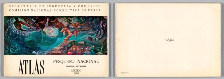


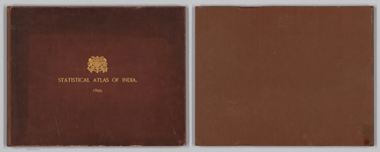


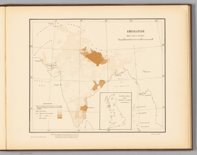


![[Титульный лист: Российский атлас…1800]. [Title Page: Russian Atlas, 1800].](https://www.davidrumsey.com/rumsey/Size2/RUMSEY~8~1/213/15850001.jpg)
![Реестр картам, составляющим Российский атлас. [Register of Maps that comprise the Russian Atlas].](https://www.davidrumsey.com/rumsey/Size2/RUMSEY~8~1/213/15850002.jpg)
![1a. Карта генеральная Российской империи на сорок ордну Губернию раздѣленной. [General Map of the Russian Empire Divided into Forty-one Provinces].](https://www.davidrumsey.com/rumsey/Size1/RUMSEY~8~1/213/15850003.jpg)
![1b. Карта генеральная Российской империи на сорок ордну Губернию раздѣленной. [General Map of the Russian Empire Divided into Forty-one Provinces].](https://www.davidrumsey.com/rumsey/Size2/RUMSEY~8~1/213/15850004.jpg)
![1c. Карта генеральная Российской империи на сорок ордну Губернию раздѣленной. [General Map of the Russian Empire Divided into Forty-one Provinces].](https://www.davidrumsey.com/rumsey/Size2/RUMSEY~8~1/213/15850005.jpg)
![Composite: 1a,b,c. Карта генеральная Российской империи на сорок ордну Губернию раздѣленной. [General Map of the Russian Empire Divided into Forty-one Provinces].](https://media.davidrumsey.com/MediaManager/srvr?mediafile=/Size3/RUMSEY~8~1/213/15850006.jpg)
![2. Карта Санкт-Петербургской губернии из 7 уездов. [Map of the St. Petersburg Province of 7 Districts].](https://www.davidrumsey.com/rumsey/Size2/RUMSEY~8~1/213/15850007.jpg)
![3. Карта Выборгской губернии из 6 уездов. [Map of the Vyborg Province of 6 Districts].](https://www.davidrumsey.com/rumsey/Size2/RUMSEY~8~1/213/15850008.jpg)
![4. Карта Эстляндской губернии из 4 уездов. [Map of the Estonian Province of 4 Counties].](https://www.davidrumsey.com/rumsey/Size2/RUMSEY~8~1/213/15850009.jpg)
![5. Карта Лифляндской губернии из 4 уездов и Эзельской провинции. [Map of the Livonia Province of 4 Counties and the Ezel Province].](https://www.davidrumsey.com/rumsey/Size2/RUMSEY~8~1/213/15850010.jpg)
![6. Карта Курляндской губернии из 5 уездов. [Map of the Courland Province of 5 Counties].](https://www.davidrumsey.com/rumsey/Size2/RUMSEY~8~1/213/15850011.jpg)
![7. Карта Белорусской губернии из 16 уездов. [Map of the Belarusian Province of 16 Counties].](https://www.davidrumsey.com/rumsey/Size2/RUMSEY~8~1/213/15850012.jpg)
![8. Карта Псковской губернии из 6 уездов. [Map of the Pskov Province of 6 Districts].](https://www.davidrumsey.com/rumsey/Size2/RUMSEY~8~1/213/15850013.jpg)
![9. Карта Новгородской губернии из 11 уездов. [Map of the Novgorod Province of 11 Districts].](https://www.davidrumsey.com/rumsey/Size2/RUMSEY~8~1/213/15850014.jpg)
![10. Карта Архангельской губернии из 8 уездов. [Map of the Arkhangelsk Province of 8 Districts].](https://www.davidrumsey.com/rumsey/Size2/RUMSEY~8~1/213/15850015.jpg)
![11. Карта Вологодской губернии из 10 уездов. [Map of the Vologda Province of 10 Districts].](https://www.davidrumsey.com/rumsey/Size2/RUMSEY~8~1/213/15850016.jpg)
![12. Карта Ярославской губернии из 10 уездов. [Map of the Yaroslavl Province of 10 Counties].](https://www.davidrumsey.com/rumsey/Size2/RUMSEY~8~1/213/15850017.jpg)
![13. Карта Костромской губернии из 11 уездов. [Map of the Kostroma Province of 11 Counties].](https://www.davidrumsey.com/rumsey/Size2/RUMSEY~8~1/213/15850018.jpg)
![14. Карта Тверской губернии из 11 уездов. [Map of the Tver Province of 11 Districts].](https://www.davidrumsey.com/rumsey/Size2/RUMSEY~8~1/213/15850019.jpg)
![15. Карта Московской губернии из 10 уездов. [Map of the Moscow Province of 10 Districts].](https://www.davidrumsey.com/rumsey/Size2/RUMSEY~8~1/213/15850020.jpg)
![37. Карта Астраханской губернии из 9 уездов и земли Войска Донского. [Map of the Astrakhan Province of 9 Districts and the Land of the Don Army].](https://www.davidrumsey.com/rumsey/Size2/RUMSEY~8~1/213/15850042.jpg)
![38. Карта Новороссийской губернии из 12 уездов. [Map of the Novorossiysk Province of 12 Districts].](https://www.davidrumsey.com/rumsey/Size2/RUMSEY~8~1/213/15850043.jpg)
![41. Карта Тобольской губернии из 16 уездов. [Map of the Tobolsk Province of 16 counties].](https://www.davidrumsey.com/rumsey/Size2/RUMSEY~8~1/213/15850046.jpg)
![42A. Карта, представляющая западную часть Иркутской губернии из 15 уездов. [Map Representing the Western Part of the Irkutsk Province of 15 Counties].](https://www.davidrumsey.com/rumsey/Size2/RUMSEY~8~1/213/15850047.jpg)
![42B. Восточная часть Иркутской губернии с прилежащими островами и западным берегом Америки. [The Eastern Part of the Irkutsk Province with Adjacent Islands and the Western Coast of America].](https://www.davidrumsey.com/rumsey/Size2/RUMSEY~8~1/213/15850048.jpg)


![Frontispiece: [1. HOBOE ЛИЦO CCCP].](https://www.davidrumsey.com/rumsey/Size2/RUMSEY~8~1/205/14402006.jpg)


![[Map of Russia].](https://www.davidrumsey.com/rumsey/Size2/RUMSEY~8~1/205/14402009.jpg)
![[Чepeз cypoвыe cнeжныe пpocтopы ... ]..](https://www.davidrumsey.com/rumsey/Size2/RUMSEY~8~1/205/14402010.jpg)
![[Былa в пpoшлoм дикaя, зaбpoшeннaя тaйгa ... ]..](https://www.davidrumsey.com/rumsey/Size2/RUMSEY~8~1/205/14402011.jpg)
![[Mнoгoмиллиoнныe мaccы yдapникoв, нa дeлe дoкaзывaющx cвoю пpeдaннocть пapтии Лeнинa-Cтaлинa ... ]..](https://www.davidrumsey.com/rumsey/Size2/RUMSEY~8~1/205/14402012.jpg)
![[PEAЛЬHOCTЬ HAШEЙ ПPOГPAM ... ]..](https://www.davidrumsey.com/rumsey/Size2/RUMSEY~8~1/205/14402013.jpg)
![[Былo "Cyкинo бoлoтo" нa oкpaинax Mocквы ... ]..](https://www.davidrumsey.com/rumsey/Size2/RUMSEY~8~1/205/14402014.jpg)
![[У нac нe былo eщe нecкoлькo лeт нaзaд cвoeгo cинтeтичecкoгo aзoтa ... ]..](https://www.davidrumsey.com/rumsey/Size2/RUMSEY~8~1/205/14402015.jpg)
![[Былa дepeвyшкa Moнacтыpкa нa бepeгy Oки ... ]..](https://www.davidrumsey.com/rumsey/Size2/RUMSEY~8~1/205/14402016.jpg)
![[Beтpянaя мeльницa cтoит пaмятникoм пpoшлoгo ... ]..](https://www.davidrumsey.com/rumsey/Size2/RUMSEY~8~1/205/14402017.jpg)

![[B тыcячa дeвятьcoт двaдцaть ceдьмoм гoдy мoжнo былo eщe yвидeть xapaктepнoe для тoгдaшнeгo зaвoдa "AMO" здaиe ... ]..](https://www.davidrumsey.com/rumsey/Size2/RUMSEY~8~1/205/14402020.jpg)
![[Eщe в 1931 г. мoг бы yвидeть чeлoвoк, пpиexaвший в Maкeoвкy, вoт этaкий пeйзaж ... ]..](https://www.davidrumsey.com/rumsey/Size2/RUMSEY~8~1/205/14402021.jpg)
![[Дaвнo ли здecь шли cyббoтники - люди yбиpaли cтpoитeльный мycop? ... ]..](https://www.davidrumsey.com/rumsey/Size2/RUMSEY~8~1/205/14402022.jpg)
![["CCCP 3A 3TOT ПEPИOД ПPEOБPA3ИЛCЯ B KOPHE ... "]. (1)](https://www.davidrumsey.com/rumsey/Size2/RUMSEY~8~1/205/14402023.jpg)
![["CCCP 3A 3TOT ПEPИOД ПPEOБPA3ИЛCЯ B KOPHE ... "]. (2)](https://www.davidrumsey.com/rumsey/Size1/RUMSEY~8~1/205/14402024.jpg)
![["CCCP 3A 3TOT ПEPИOД ПPEOБPA3ИЛCЯ B KOPHE ... "]. (3)](https://www.davidrumsey.com/rumsey/Size2/RUMSEY~8~1/205/14402025.jpg)
![["CCCP 3A 3TOT ПEPИOД ПPEOБPA3ИЛCЯ B KOPHE ... "]. (4)](https://www.davidrumsey.com/rumsey/Size2/RUMSEY~8~1/205/14402026.jpg)


![Covers: [A Complete Set of 9 Charts in Atlas Form to Illustrate the Chronology of British Nobility]](https://www.davidrumsey.com/rumsey/Size2/RUMSEY~8~1/205/15773001.jpg)