|
Author
Fremont, J.C.
Full Title
Map Of Oregon And Upper California (Showing the Gold Regions) From the Surveys of John Charles Fremont And other Authorities. Drawn By Charles Preuss Under the Order of the Senate Of The United States, Washington City 1848. Lithy. by E. Weber & Co. Balto. (inset) Profile of the travelling route from the South Pass of the Rocky Mountains to the Bay of San Francisco.
List No
10508.002
Author
Jackson, William A.
Full Title
(Covers to) Map of the Mining District of California by Wm. A. Jackson. Copyright secured. Entered ... 1850 by Theodore A. Mudge ... New York. Lambert & Lane's Litho. No. 69 Wall St. N.Y. (Reprint by Thomas W. Norris, Livermore, Calif. December 25, 1936).
List No
2229.001
Note
Reprint of the 1st edition, 1849, with 12 page Appendix. Folded into red cloth covers 15.5x9 with "Jackson's Map of California With Appendix 1850" stamped in gold.
Author
Jackson, William A.
Full Title
(Text Page to) Appendix to Jackson's Map of the Mining District of California Dec. 1849. Map of the Mining District of California by Wm. A. Jackson. Copyright secured. Entered ... 1850 by Theodore A. Mudge ... New York. Lambert & Lane's Litho. No. 69 Wall St. N.Y. (Reprint by Thomas W. Norris, Livermore, Calif. December 25, 1936).
List No
2229.002
Note
Reprint of the 1st edition, 1849, with 12 page Appendix. Folded into red cloth covers 15.5x9 with "Jackson's Map of California With Appendix 1850" stamped in gold.
Author
Jackson, William A.
Full Title
Map of the Mining District of California by Wm. A. Jackson. Copyright secured. Entered ... 1850 by Theodore A. Mudge ... New York. Lambert & Lane's Litho. No. 69 Wall St. N.Y. (Reprint by Thomas W. Norris, Livermore, Calif. December 25, 1936).
List No
2229.003
Note
Reprint of the 1st edition, 1849, with 12 page Appendix. Folded into red cloth covers 15.5x9 with "Jackson's Map of California With Appendix 1850" stamped in gold.
Author
[Gibbes, C.D., Holt, Warren]
Full Title
Map of the States Of California And Nevada. Carefully Compiled from the Latest Authentic Sources. By Chas. Drayton Gibbes, C.E. Comprising Information obtained from the U.S. Coast And Land Surveys ... And Others. Published by Warren Holt. No. 607 Clay Street, San Francisco, Cal. 1873. Entered ... 1873 by Warren Holt ... Washington. S. Blinton Formerly of the U.S. Coast Survey Draughtsman & Lithographer. 148-1/2 S. Fourth Street, Philadelphia, Pa.
List No
2479.002
Note
First edition, first state, with 11 Land Districts, the Northeastern corner of California shown as "unexplored," and no Eureka County in Nevada. The ornamental border is narrower than the second state issue - about 1/4 inch versus almost 1/2 inch. There may be other differences. This state is scarce. See our #2479 for the second state. Map is folded into burgandy cloth covers 16x10 with "Holt's Map Of California And Nevada." in gilt.
Author
Jackson, William A.
Full Title
(Covers to) Map Of The Mining District of California by Wm. A. Jackson. Published by Lambert & Lane, 69 Wall St. New York. Entered ... 1851 by Lambert & Lane ... New York. (with 16 page appendix) Appendix To Jackson's Map Of The Mining Districts Of California. ... Second Edition, Revised And Enlarged. New-York: Lambert & Lane, 69 Wall-Street. 1851.
List No
2545A
Author
Jackson, William A.
Full Title
Map Of The Mining District of California by Wm. A. Jackson. Published by Lambert & Lane, 69 Wall St. New York. Entered ... 1851 by Lambert & Lane ... New York. (with 16 page appendix) Appendix To Jackson's Map Of The Mining Districts Of California. ... Second Edition, Revised And Enlarged. New-York: Lambert & Lane, 69 Wall-Street. 1851.
List No
2545.001
Note
This is one of the most attractive of the California Gold Rush period maps. Here it is published in pocket map form, with the 16 page "Appendix to Jackson's Map..." which describes the important mining centers. More ornate and detailed than Jackson's map of 1850, this is the only map to label Santa Cruz county "Branciforte." Shows for the first time, some of the mining activity in the south, which Jackson was involved with as an engineer. Map is full color by county, folded into dark green cloth covers 15x10 with "Jackson's Map Of The Mining Districts Of California" stamped in gilt.
Author
Bolitho, Edwin
Full Title
United States. (to accompany) Pocket Mining Atlas. Compiled From The Latest Official Surveys, And The Most Authentic Sources. Edwin Bolitho, Engineering and Mining Journal, New York, 1880. Price, $1.00 per copy. (on following page) Entered ... 1880 ... Washington, D.C., by Trask & Francis, Bankers ... 70 Broadway, New York ...
List No
3054.004
Note
Full color map by states. Relief shown by hachures. Prime meridian is Greenwich.
Author
Bolitho, Edwin
Full Title
Southern States. (to accompany) Pocket Mining Atlas. Compiled From The Latest Official Surveys, And The Most Authentic Sources. Edwin Bolitho, Engineering and Mining Journal, New York, 1880. Price, $1.00 per copy. (on following page) Entered ... 1880 ... Washington, D.C., by Trask & Francis, Bankers ... 70 Broadway, New York ...
List No
3054.005
Note
Full color map by states. Prime meridian is Washington, D.C.
Author
Bolitho, Edwin
Full Title
Map of the Dahlonega Distrtict, GA. (to accompany) Pocket Mining Atlas. Compiled From The Latest Official Surveys, And The Most Authentic Sources. Edwin Bolitho, Engineering and Mining Journal, New York, 1880. Price, $1.00 per copy. (on following page) Entered ... 1880 ... Washington, D.C., by Trask & Francis, Bankers ... 70 Broadway, New York ...
List No
3054.006
Note
Full color map. Showing districts and counties.
Author
Bolitho, Edwin
Full Title
Copper and Iron District of Lake Superior Michigan. (to accompany) Pocket Mining Atlas. Compiled From The Latest Official Surveys, And The Most Authentic Sources. Edwin Bolitho, Engineering and Mining Journal, New York, 1880. Price, $1.00 per copy. (on following page) Entered ... 1880 ... Washington, D.C., by Trask & Francis, Bankers ... 70 Broadway, New York ...
List No
3054.007
Note
Full color map. Showing railroad and rivers. Relief shown by hachures.
Author
Bolitho, Edwin
Full Title
Dakota. (to accompany) Pocket Mining Atlas. Compiled From The Latest Official Surveys, And The Most Authentic Sources. Edwin Bolitho, Engineering and Mining Journal, New York, 1880. Price, $1.00 per copy. (on following page) Entered ... 1880 ... Washington, D.C., by Trask & Francis, Bankers ... 70 Broadway, New York ...
List No
3054.008
Note
Full color map. Prime meridian is Washington, D.C.
Author
Bolitho, Edwin
Full Title
Deadwood, Black Hills Dakota. (to accompany) Pocket Mining Atlas. Compiled From The Latest Official Surveys, And The Most Authentic Sources. Edwin Bolitho, Engineering and Mining Journal, New York, 1880. Price, $1.00 per copy. (on following page) Entered ... 1880 ... Washington, D.C., by Trask & Francis, Bankers ... 70 Broadway, New York ...
List No
3054.009
Note
Full color map. Showing Deawood and surroundings. Relief shown by hachures.
Author
Bolitho, Edwin
Full Title
Montana. (to accompany) Pocket Mining Atlas. Compiled From The Latest Official Surveys, And The Most Authentic Sources. Edwin Bolitho, Engineering and Mining Journal, New York, 1880. Price, $1.00 per copy. (on following page) Entered ... 1880 ... Washington, D.C., by Trask & Francis, Bankers ... 70 Broadway, New York ...
List No
3054.010
Note
Full color map. Prime meridian is Washington, D.C.
Author
Bolitho, Edwin
Full Title
Idaho. (to accompany) Pocket Mining Atlas. Compiled From The Latest Official Surveys, And The Most Authentic Sources. Edwin Bolitho, Engineering and Mining Journal, New York, 1880. Price, $1.00 per copy. (on following page) Entered ... 1880 ... Washington, D.C., by Trask & Francis, Bankers ... 70 Broadway, New York ...
List No
3054.011
Note
Full color map. Prime meridian is Greenwich.
Author
Bolitho, Edwin
Full Title
Colorado. Russell & Struthers, Engr's N. Y. (to accompany) Pocket Mining Atlas. Compiled From The Latest Official Surveys, And The Most Authentic Sources. Edwin Bolitho, Engineering and Mining Journal, New York, 1880. Price, $1.00 per copy. (on following page) Entered ... 1880 ... Washington, D.C., by Trask & Francis, Bankers ... 70 Broadway, New York ...
List No
3054.012
Note
Full color map. Prime meridian is Washington, D.C.
Author
Bolitho, Edwin
Full Title
Map of San Juan, Colorado. (to accompany) Pocket Mining Atlas. Compiled From The Latest Official Surveys, And The Most Authentic Sources. Edwin Bolitho, Engineering and Mining Journal, New York, 1880. Price, $1.00 per copy. (on following page) Entered ... 1880 ... Washington, D.C., by Trask & Francis, Bankers ... 70 Broadway, New York ...
List No
3054.013
Note
Full color map. Showing San Juan, Ouray and Hinsdale. Relief shown by hachures. Prime meridian is Washington, D.C.
Author
Bolitho, Edwin
Full Title
Leadville District, Colorado. No. 1. (to accompany) Pocket Mining Atlas. Compiled From The Latest Official Surveys, And The Most Authentic Sources. Edwin Bolitho, Engineering and Mining Journal, New York, 1880. Price, $1.00 per copy. (on following page) Entered ... 1880 ... Washington, D.C., by Trask & Francis, Bankers ... 70 Broadway, New York ...
List No
3054.014
Note
Full color map. Showing Leadville District and surroundings.
Author
Bolitho, Edwin
Full Title
Leadville District, Colorado. No. 2. (to accompany) Pocket Mining Atlas. Compiled From The Latest Official Surveys, And The Most Authentic Sources. Edwin Bolitho, Engineering and Mining Journal, New York, 1880. Price, $1.00 per copy. (on following page) Entered ... 1880 ... Washington, D.C., by Trask & Francis, Bankers ... 70 Broadway, New York ...
List No
3054.015
Note
Full color map. Showing Leadville District and surroundings.
Author
Bolitho, Edwin
Full Title
Central City District, Col. (to accompany) Pocket Mining Atlas. Compiled From The Latest Official Surveys, And The Most Authentic Sources. Edwin Bolitho, Engineering and Mining Journal, New York, 1880. Price, $1.00 per copy. (on following page) Entered ... 1880 ... Washington, D.C., by Trask & Francis, Bankers ... 70 Broadway, New York ...
List No
3054.016
Note
Full color map. Showing gold and silver belt.
Author
Bolitho, Edwin
Full Title
Silver Cliff District, Colorado. (to accompany) Pocket Mining Atlas. Compiled From The Latest Official Surveys, And The Most Authentic Sources. Edwin Bolitho, Engineering and Mining Journal, New York, 1880. Price, $1.00 per copy. (on following page) Entered ... 1880 ... Washington, D.C., by Trask & Francis, Bankers ... 70 Broadway, New York ...
List No
3054.017
Note
Full color map. Relief shown by hachures.
Author
Bolitho, Edwin
Full Title
Map of Caribou Hill, Grand Island Mining District, Boulder County, Colorado. (to accompany) Pocket Mining Atlas. Compiled From The Latest Official Surveys, And The Most Authentic Sources. Edwin Bolitho, Engineering and Mining Journal, New York, 1880. Price, $1.00 per copy. (on following page) Entered ... 1880 ... Washington, D.C., by Trask & Francis, Bankers ... 70 Broadway, New York ...
List No
3054.018
Note
Full color map. Relief shown by hachures.
Author
Bolitho, Edwin
Full Title
Utah. (to accompany) Pocket Mining Atlas. Compiled From The Latest Official Surveys, And The Most Authentic Sources. Edwin Bolitho, Engineering and Mining Journal, New York, 1880. Price, $1.00 per copy. (on following page) Entered ... 1880 ... Washington, D.C., by Trask & Francis, Bankers ... 70 Broadway, New York ...
List No
3054.019
Note
Full color map. Prime meridian is Washington, D.C.
Author
Bolitho, Edwin
Full Title
Nevada. (to accompany) Pocket Mining Atlas. Compiled From The Latest Official Surveys, And The Most Authentic Sources. Edwin Bolitho, Engineering and Mining Journal, New York, 1880. Price, $1.00 per copy. (on following page) Entered ... 1880 ... Washington, D.C., by Trask & Francis, Bankers ... 70 Broadway, New York ...
List No
3054.020
Note
Full color map. Prime meridian is Washington, D.C.
Author
Bolitho, Edwin
Full Title
Comstock District, Nevada. No. 1. (to accompany) Pocket Mining Atlas. Compiled From The Latest Official Surveys, And The Most Authentic Sources. Edwin Bolitho, Engineering and Mining Journal, New York, 1880. Price, $1.00 per copy. (on following page) Entered ... 1880 ... Washington, D.C., by Trask & Francis, Bankers ... 70 Broadway, New York ...
List No
3054.021
Note
Full color map.
Author
Bolitho, Edwin
Full Title
Comstock District, Nevada. No. 2. (to accompany) Pocket Mining Atlas. Compiled From The Latest Official Surveys, And The Most Authentic Sources. Edwin Bolitho, Engineering and Mining Journal, New York, 1880. Price, $1.00 per copy. (on following page) Entered ... 1880 ... Washington, D.C., by Trask & Francis, Bankers ... 70 Broadway, New York ...
List No
3054.022
Note
Full color map. Relief shown by hachures and spot heights.
Author
Bolitho, Edwin
Full Title
Eureka Mining District, Nevada. (to accompany) Pocket Mining Atlas. Compiled From The Latest Official Surveys, And The Most Authentic Sources. Edwin Bolitho, Engineering and Mining Journal, New York, 1880. Price, $1.00 per copy. (on following page) Entered ... 1880 ... Washington, D.C., by Trask & Francis, Bankers ... 70 Broadway, New York ...
List No
3054.023
Note
Full color map. Includes list of references. Relief shown by hachures.
Author
Bolitho, Edwin
Full Title
Eureka Mining District, Nevada. (to accompany) Pocket Mining Atlas. Compiled From The Latest Official Surveys, And The Most Authentic Sources. Edwin Bolitho, Engineering and Mining Journal, New York, 1880. Price, $1.00 per copy. (on following page) Entered ... 1880 ... Washington, D.C., by Trask & Francis, Bankers ... 70 Broadway, New York ... (inset map) Boundary Line of town of Eureka.
List No
3054.024
Note
Full color map. Includes list of references. Relief shown by hachures.
Author
Bolitho, Edwin
Full Title
Map of Treasure Hill, White Pine County, Nevada. Russell & Struthers, Engr's N. Y. (to accompany) Pocket Mining Atlas. Compiled From The Latest Official Surveys, And The Most Authentic Sources. Edwin Bolitho, Engineering and Mining Journal, New York, 1880. Price, $1.00 per copy. (on following page) Entered ... 1880 ... Washington, D.C., by Trask & Francis, Bankers ... 70 Broadway, New York ...
List No
3054.025
Note
Full color map. Relief shown by hachures.
Author
Bolitho, Edwin
Full Title
Tuscarora Mining District, Elco County, Nevada. (to accompany) Pocket Mining Atlas. Compiled From The Latest Official Surveys, And The Most Authentic Sources. Edwin Bolitho, Engineering and Mining Journal, New York, 1880. Price, $1.00 per copy. (on following page) Entered ... 1880 ... Washington, D.C., by Trask & Francis, Bankers ... 70 Broadway, New York ...
List No
3054.026
Note
Full color map. Relief shown by hachures.
Author
Bolitho, Edwin
Full Title
California. (to accompany) Pocket Mining Atlas. Compiled From The Latest Official Surveys, And The Most Authentic Sources. Edwin Bolitho, Engineering and Mining Journal, New York, 1880. Price, $1.00 per copy. (on following page) Entered ... 1880 ... Washington, D.C., by Trask & Francis, Bankers ... 70 Broadway, New York ...
List No
3054.027
Note
Full color map. Relief shown by hachures. Prime meridian is Washington, D.C.
Author
Bolitho, Edwin
Full Title
Bodie District, California. (to accompany) Pocket Mining Atlas. Compiled From The Latest Official Surveys, And The Most Authentic Sources. Edwin Bolitho, Engineering and Mining Journal, New York, 1880. Price, $1.00 per copy. (on following page) Entered ... 1880 ... Washington, D.C., by Trask & Francis, Bankers ... 70 Broadway, New York ...
List No
3054.028
Note
Full color map. Relief shown by hachures.
Author
Bolitho, Edwin
Full Title
New Mexico. (to accompany) Pocket Mining Atlas. Compiled From The Latest Official Surveys, And The Most Authentic Sources. Edwin Bolitho, Engineering and Mining Journal, New York, 1880. Price, $1.00 per copy. (on following page) Entered ... 1880 ... Washington, D.C., by Trask & Francis, Bankers ... 70 Broadway, New York ...
List No
3054.029
Note
Full color map. Prime meridian is Washington, D.C.
Author
Bolitho, Edwin
Full Title
Arizona. (to accompany) Pocket Mining Atlas. Compiled From The Latest Official Surveys, And The Most Authentic Sources. Edwin Bolitho, Engineering and Mining Journal, New York, 1880. Price, $1.00 per copy. (on following page) Entered ... 1880 ... Washington, D.C., by Trask & Francis, Bankers ... 70 Broadway, New York ...
List No
3054.030
Note
Full color map. Prime meridian is Washington, D.C.
Author
Lee, Alex. Y.
Full Title
(Covers to) Lee's Map Of The Industries Of Western Pennsylvania. No. 1, being an Indexed Map Of The Connellsville Coke Field and Pittsburgh Gas Coal Beds, also showing the Various Transportation Lines traversing this field and centering at Pittsburgh, Pa. In connection with this map is issued A Detailed Map No.2 of Pittsburgh. Copyright 1884 by Alex. Y. Lee C.E. Pittsburgh, Pa. ... The Railway Map and Publishing Co. 88 Warren St. New York.
List No
3213.001
Note
Shows almost 150 Collieries and Cokeries around Pittsburgh. All the industrial establishments and the railroads and rivers connecting them to Pittsburgh are identified and indexed. This map shows Pittsburgh's industrial landscape during the period of expansion. There are ads for the Crescent Steel Works on the map and on the verso of the front cover; the green cloth covers 20x12 are stamped with "Industries of Western Penna. Lee. Presented By Miller, Metcalf & Parkin, Cresent Steel Works, Pittsburgh, Pa." in gold. An unusual "industrial thematic" map. Full color.
Author
Lee, Alex. Y.
Full Title
Lee's Map Of The Industries Of Western Pennsylvania. No. 1, being an Indexed Map Of The Connellsville Coke Field and Pittsburgh Gas Coal Beds, also showing the Various Transportation Lines traversing this field and centering at Pittsburgh, Pa. In connection with this map is issued A Detailed Map No.2 of Pittsburgh. Copyright 1884 by Alex. Y. Lee C.E. Pittsburgh, Pa. ... The Railway Map and Publishing Co. 88 Warren St. New York.
List No
3213.002
Note
Shows almost 150 Collieries and Cokeries around Pittsburgh. All the industrial establishments and the railroads and rivers connecting them to Pittsburgh are identified and indexed. This map shows Pittsburgh's industrial landscape during the period of expansion. There are ads for the Crescent Steel Works on the map and on the verso of the front cover; the green cloth covers 20x12 are stamped with "Industries of Western Penna. Lee. Presented By Miller, Metcalf & Parkin, Cresent Steel Works, Pittsburgh, Pa." in gold. An unusual "industrial thematic" map. Full color.
Author
Thayer, H.L.
Full Title
(Covers to) Thayer's Map Of The Leadville Mines California Mining District Lake County Colorado. ... Compiled From The United States Surveys And County Records. Published by H.L. Thayer, Leadville, Colorado. Julius Bien, Photo-Lith. N.Y.
List No
4334.001
Note
Highly detailed map showing a hurricane of claims with owner's names, all tumbled over each other in classic mining frenzy. Uncolored, with a catalog of Thayer's maps in the lower right corner of the map and the inside front cover; also on the inside front cover: "We cheerfully endorse 'Thayer's Map of the Leadville Mines' as the best published for completeness and accuracy" (followed by a long list of Mineral Surveyors). Map is folded into brown cloth covers 16x10.5 with "Thayer's Map Of The Leadville Mines. Price $1.50." stamped in gilt. Not in Streeter or Phillips. The scarcest of the Leadville claim maps.
Author
Thayer, H.L.
Full Title
Thayer's Map Of The Leadville Mines California Mining District Lake County Colorado. ... Compiled From The United States Surveys And County Records. Published by H.L. Thayer, Leadville, Colorado. Julius Bien, Photo-Lith. N.Y.
List No
4334.002
Note
Highly detailed map showing a hurricane of claims with owner's names, all tumbled over each other in classic mining frenzy. Uncolored, with a catalog of Thayer's maps in the lower right corner of the map and the inside front cover; also on the inside front cover: "We cheerfully endorse 'Thayer's Map of the Leadville Mines' as the best published for completeness and accuracy" (followed by a long list of Mineral Surveyors). Map is folded into brown cloth covers 16x10.5 with "Thayer's Map Of The Leadville Mines. Price $1.50." stamped in gilt. Not in Streeter or Phillips. The scarcest of the Leadville claim maps.
Author
Clason Map Company
Full Title
(Covers to) Approved Mineral Surveys Of The Principal Mining Districts In Boulder County Colorado. 1916. Published By The Clason Map Co. 1515 Tremont Place, Denver, Colo. Copyrighted 1916 by The Clason Map Co. Denver, Colo.
List No
4504.001
Note
A very detailed map of mining claims in Boulder County. Folded into beige card board covers 17x10 printed with "Clason Map Of The Boulder County Mining District Colorado. Gold -- Silver Tungsten Price $1.00 The Clason Map Co. Publishers Denver, Colorado."
Author
Clason Map Company
Full Title
Approved Mineral Surveys Of The Principal Mining Districts In Boulder County Colorado. 1916. Published By The Clason Map Co. 1515 Tremont Place, Denver, Colo. Copyrighted 1916 by The Clason Map Co. Denver, Colo.
List No
4504.002
Note
A very detailed map of mining claims in Boulder County. Folded into beige card board covers 17x10 printed with "Clason Map Of The Boulder County Mining District Colorado. Gold -- Silver Tungsten Price $1.00 The Clason Map Co. Publishers Denver, Colorado."
Author
Rand McNally and Company
Full Title
(Covers to) Rand, McNally & Co.'s new geological map of Colorado. Copyright, 1879, by Rand, McNally & Co.
List No
4788A
Note
This is a very unusual map for Rand McNally to issue - geological maps were not common in their catalog and this may be the only one they published. It was probably the interest in mining that motivated publication and the inclusion of "Mineralogical References" in the map key. The main source for the geological formations was Hayden's General Geological Map of Colorado that appeared in his 1877 Atlas of Colorado. But Rand McNally's map has much more detail on towns and railroads than Hayden and is a much superior map in that respect. Ellis 82 is the 1880 edition, which was also issued without geological coloring as "Rand McNally & Co.'s New Sectional Map of Colorado." This map is in printed full color, folded into dark blue cloth covers 16.5x10 titled "Rand, McNally & Co's geological and mineralogical maps Of Colorado" in gold.
Author
Rand McNally and Company
Full Title
Rand, McNally & Co.'s new geological map of Colorado. Copyright, 1879, by Rand, McNally & Co.
List No
4788.001
Note
This is a very unusual map for Rand McNally to issue - geological maps were not common in their catalog and this may be the only one they published. It was probably the interest in mining that motivated publication and the inclusion of "Mineralogical References" in the map key. The main source for the geological formations was Hayden's General Geological Map of Colorado that appeared in his 1877 Atlas of Colorado. But Rand McNally's map has much more detail on towns and railroads than Hayden and is a much superior map in that respect. Ellis 82 is the 1880 edition, which was also issued without geological coloring as "Rand McNally & Co.'s New Sectional Map of Colorado." This map is in printed full color, folded into dark blue cloth covers 16.5x10 titled "Rand, McNally & Co's geological and mineralogical maps Of Colorado" in gold.
Author
[Colton, J. H., Warren, Gouverneur Kemble, 1830-1882, Redpath, James, Hinton, Richard J]
Full Title
Kansas and Nebraska. 1859. (inset map) Nebraska and Kansas, Showing Pikes Peak And The Gold Region. 1859. (Published) by J.H. Colton & Co., 172 William St., New York.
List No
4872.004
Note
An important early guide to the Colorado Gold Region, with three Colton maps on two sheets: "Kansas and Nebraska...1859," which is taken from the 1858 General Atlas, minus the upper half of Nebraska - shows eastern Kansas and Nebraska; "Nebraska and Kanzas, Showing Pikes Peak And The Gold Region...1859," which is the lower half of the 1857 General Atlas map of the same title (without the reference to the Gold Region); and "Military Map of Parts of Kansas, Nebraska and Dakota by Lieut. G.K. Warren Top. Engrs. from the Explorations made by him in 1855, 56 & 57... J.H. Colton... New York," which is derived from the lower half of Warren's 1858/1859 "Military Map of Nebraska and Dakota" (see our #2932). The "Nebraska and Kanzas, Showing Pikes Peak..." map appeared as the only map in J.W. Reed's 1859 "Map of and Guide to the Kansas Gold Region (WC343a), also published by J.H. Colton. Bound in brown linen 15x10, with "Guide to Kansas, The Pike's Peak Gold Region &c. &c. J.H. Colton New York" in gold on the cover. Prime meridians are Washington D.C. and Greenwich.
Author
[Colton, J. H., Warren, Gouverneur Kemble, 1830-1882, Redpath, James, Hinton, Richard J]
Full Title
Military Map of Parts of Kansas, Nebraska and Dakota. By Lieut. G.K. Warren Top. Engrs. from the Explorations made by him in 1855, 56 & 57. (Published) by J.H. Colton & Co., 172 William St., New York.
List No
4872.005
Note
An important early guide to the Colorado Gold Region, with three Colton maps on two sheets: "Kansas and Nebraska...1859," which is taken from the 1858 General Atlas, minus the upper half of Nebraska - shows eastern Kansas and Nebraska; "Nebraska and Kanzas, Showing Pikes Peak And The Gold Region...1859," which is the lower half of the 1857 General Atlas map of the same title (without the reference to the Gold Region); and "Military Map of Parts of Kansas, Nebraska and Dakota by Lieut. G.K. Warren Top. Engrs. from the Explorations made by him in 1855, 56 & 57... J.H. Colton... New York," which is derived from the lower half of Warren's 1858/1859 "Military Map of Nebraska and Dakota" (see our #2932). The "Nebraska and Kanzas, Showing Pikes Peak..." map appeared as the only map in J.W. Reed's 1859 "Map of and Guide to the Kansas Gold Region (WC343a), also published by J.H. Colton. Bound in brown linen 15x10, with "Guide to Kansas, The Pike's Peak Gold Region &c. &c. J.H. Colton New York" in gold on the cover. Prime meridians are Washington D.C. and Greenwich.
Author
[Strauch, Geo. B., Cochran, A.B.]
Full Title
(Covers to) The Anthracite Coal Fields Of Pennsylvania With Their Outlets To Market. By Geo. B. Strauch And A.B. Cochran, Mining Engineers, Pottsville, Pa. 1878. Entered ... 1878 by Strauch & Cochran ... Washington D.C. T. Sinclair & Son. lith. Phila. (inset) Anthracite Coal Fields And Their Outlets To Market. Strauch & Cochran 1878
List No
4904.001
Note
Shows the four major coal fields of Eastern Pennsylvania, with an inset map on a smaller scale showing the market outlets to New York, Baltimore and Philadelphia. There is a list of 291 Anthracite Collieries operating in the coal fields, statistics on annual shipments of anthracite coal, list of distances to market, and areas of coal fields. Folded into dark brown cloth covers 15.5x10 with "Anthracite Coal Fields Of Pennsylvania Strauch & Cochran 1878" stamped in gilt.
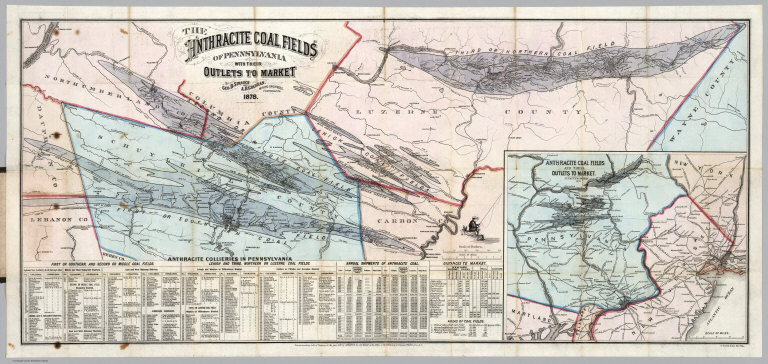
Author
[Strauch, Geo. B., Cochran, A.B.]
Full Title
The Anthracite Coal Fields Of Pennsylvania With Their Outlets To Market. By Geo. B. Strauch And A.B. Cochran, Mining Engineers, Pottsville, Pa. 1878. Entered ... 1878 by Strauch & Cochran ... Washington D.C. T. Sinclair & Son. lith. Phila. (inset) Anthracite Coal Fields And Their Outlets To Market. Strauch & Cochran 1878
List No
4904.002
Note
Color map. Shows the four major coal fields of Eastern Pennsylvania, with an inset map on a smaller scale showing the market outlets to New York, Baltimore and Philadelphia. There is a list of 291 Anthracite Collieries operating in the coal fields, statistics on annual shipments of anthracite coal, list of distances to market, and areas of coal fields.
Author
[Colton, G. W. & C. B., Swann, John S.]
Full Title
(Covers to) Title Map of the Coal Field Of The Great Kanawha Valley West Virginia, United States of America. By John S. Swann, Attorney at Law, Charleston, Kanawha County W. Va. Engraved, Printed, And Manufactured By G.W. & C.B. Colton & Co. No. 172 Williams St New York. Price of Map $10.00 To Be Procured Of Thomas L. Broun ... and John S. Swann ... Entered ... 1867, by John S. Swann ... Charleston, West Virginia. (inset) West Virginia Showing the rail and water communication Between The Great Kanawha District And Pittsburgh & Cincinnati.
List No
4965A
Note
Huge, large scale map of one of the early and important coal regions of West Virginia. Land owners' holdings are shown in color with dates of original patents (George Washington had large holdings here). Six sections show the amount and kinds of coal found at different parts of the valley. An inset map of West Virginia shows the current and future water and rail connections between the Kanawha Valley and Pittsburgh and Cincinnati. Several columns of text describe the geography, climate, and types of coal to be found. The sheer amount of information is impressive. This must be one of the best coal mining maps of its time, if not the largest. Map folds into embossed dark brown cloth covers 22x15 with "Title Map Of The Great Kanawha Coal Field. John S. Swann." in gilt.
Author
[Colton, G. W. & C. B., Swann, John S.]
Full Title
Title Map of the Coal Field Of The Great Kanawha Valley West Virginia, United States of America. By John S. Swann, Attorney at Law, Charleston, Kanawha County W. Va. Engraved, Printed, And Manufactured By G.W. & C.B. Colton & Co. No. 172 Williams St New York. Price of Map $10.00 To Be Procured Of Thomas L. Broun ... and John S. Swann ... Entered ... 1867, by John S. Swann ... Charleston, West Virginia. (inset) West Virginia Showing the rail and water communication Between The Great Kanawha District And Pittsburgh & Cincinnati.
List No
4965.001
Note
Huge, large scale map of one of the early and important coal regions of West Virginia. Land owners' holdings are shown in color with dates of original patents (George Washington had large holdings here). Six sections show the amount and kinds of coal found at different parts of the valley. An inset map of West Virginia shows the current and future water and rail connections between the Kanawha Valley and Pittsburgh and Cincinnati. Several columns of text describe the geography, climate, and types of coal to be found. The sheer amount of information is impressive. This must be one of the best coal mining maps of its time, if not the largest. Map folds into embossed dark brown cloth covers 22x15 with "Title Map Of The Great Kanawha Coal Field. John S. Swann." in gilt.
Author
[Smith, J.L., Smith, A. DW.]
Full Title
(Covers to) General Map Of The Anthracite Coal Fields Of Pennsylvania And Adjoining Counties Showing The Position Of Each Colliery. By A. DW. Smith, Mining Engineer. Wilkes-Barre, Penna. Published by J.L. Smith, Map Publisher, 27 S. 6th St., Philadelphia 1899. Copyrighted 1899 By A. DW. Smith. (inset) Map Showing The Railroad Outlets Of The Anthracite Coal Regions Of Pennsylvania.
List No
5069.001
Note
Late, detailed map of the Pennsylvania coal fields; folded into dark brown cloth covers 19x11 with "Anthracite Coal Fields Of Pennsylvania J.L. Smith 1899" in gilt. On the map is a note: "This map is a revised copy of the 'General Map of the Anthracite Coal Fields' published by the Pennsylvania Geological Survey in 1890; and is republished by permission of the Board of Commissioners."
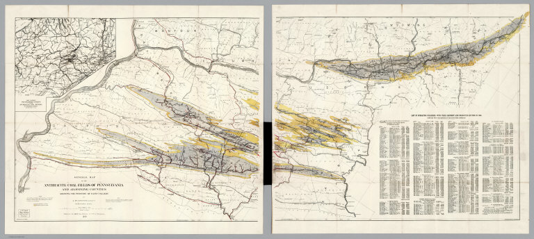
Author
[Smith, J.L., Smith, A. DW.]
Full Title
General Map Of The Anthracite Coal Fields Of Pennsylvania And Adjoining Counties Showing The Position Of Each Colliery. By A. DW. Smith, Mining Engineer. Wilkes-Barre, Penna. Published by J.L. Smith, Map Publisher, 27 S. 6th St., Philadelphia 1899. Copyrighted 1899 By A. DW. Smith. (inset) Map Showing The Railroad Outlets Of The Anthracite Coal Regions Of Pennsylvania.
List No
5069.002
Note
Late, detailed map of the Pennsylvania coal fields. On the map is a note: "This map is a revised copy of the 'General Map of the Anthracite Coal Fields' published by the Pennsylvania Geological Survey in 1890; and is republished by permission of the Board of Commissioners." Includes a "List of operating collieries, with their shipment and production in Tons in 1898". Prime meridian is Washington.
|