|
Author
[Canet Alvarez, Gerardo A., 1911-, Raisz, Erwin, 1893-1968, Harvard University. Institute of Geographical Exploration, Cuba. Ministerio de Agricultura]
Full Title
Cuba insurrecta : Primeras luchas -- La guerra del '68 -- La guerra del '95.
List No
14350.009
Note
Three maps showing the history of Cuba in the nineteenth and twentieth centuries. Titles translate to: Insurrectionary Cuba : First struggles -- The war of '68 -- The war of '95. Maps show cities, coastlines and locations of military events. Maps include pictorial elements and descriptive text, which appears in Spanish, with English translations. Accompanied by a timeline on left, which spans the dates 1840 to 1940 and lists historical events. With illustrations, charts and diagram, which represents population.
Author
[Glinka, Grigorii Viacheslavich, 1862-1934, Russia. Pereselencheskoe upravlenīe.]
Full Title
No. No. 10. Karta Pravoslavnaya Eparkhiya Aziatskoi Rossii. 11. Karta Voennykh' Okrugav' Aziatskoi Rossii. 12. Karta Okrugov' sude'nykh' palat' v Aziatskoi Rossii. 13. Karta Uchebnykh Okrugov Aziatskoi Rossii. (to accompany) Atlas Aziatskoi Rossii. Izdanie. 1914.
List No
13437.023
Note
4 maps on double page plates, including Asian Russia's Orthodox Diocese, Military Districts, Judicial Districts, and educational districts. Including color coded reference.
Author
Aspioti-ELKA (Firm)
Full Title
EΛΛHNOÏTAΛIKOΣ ΠOΛEMOΣ : ΠPΩTH ΠEPIOΔOΣ 28/10/1940-8/11/1940.
List No
14295.029
Note
Colored map of Greece, showing Italian military attacks on Greece from August 11th, 1940 to October 28th, 1940. Delineates between Greek and Albanian territory, where each suffered "Italian penetration". Also shows international political borders, cities, coastlines and islands. Includes a scale statement and an indexed legend, which the descriptive text on facing page explains. Accompanying text appears in Greek, French, English and Russian, entitled, The Italian agression. Description begins: But destiny prevented the Greek people from living and working in its poor country which he developed by his own toil ... Map is 39 x 31 cm, on sheet 47 x 35 cm. (Plate number 10, according to descriptive text.) Within the second section of the atlas, Greece at war.
Author
Aspioti-ELKA (Firm)
Full Title
EΛΛHNOΓEPMANIKOΣ ΠOΛEMOΣ : ΠPΩTH ΠEPIOΔOΣ 6 ATTP. - 17 ATTP. 1941.
List No
14295.033
Note
Colored map of Greece, showing German military attacks on Greece from April 6th to 17th, 1941. Delineates between German offensives during April 6-12 and April 13-17, 1941. First in a series of three maps that represent German attacks on Greece in 1941. Also shows international political borders, cities, coastlines and islands. Includes a scale statement and an indexed legend, which the descriptive text on facing page explains. Accompanying text appears in Greek, French, English and Russian, entitled, German attack A. Description begins: But the big Italian concentrations and Mussoini's spring offensives were all of no avail ... Map is 39 x 31 cm, on sheet 47 x 35 cm. (Plate number 12, according to descriptive text.) Within the second section of the atlas, Greece at war.
Author
Aspioti-ELKA (Firm)
Full Title
EXΘPIKH KATOXH-ΔIAMEΛIΣMOΣ THΣ XΩPAΣ : ΠPΩTH ΠEPIOΔOΣ 1941-1942.
List No
14295.039
Note
Colored map of Greece, showing the Italian, German and Bulgarian Occupation of Greece from 1943 to 1944. Delineates between the areas occupied by the Italians, Germans and Bulgarian. First in a series of four maps that represent military activity in Greece from 1941 to 1944. With national flags indicating boundaries. Also shows international political borders, cities, coastlines and islands. Includes a scale statement and an indexed legend, which the descriptive text on facing page explains. Accompanying text appears in Greek, French, English and Russian, entitled, Second phase of the Occupation. Description begins: At once the axis forces divided Greece into many zones and allocated them to the Germans, the Italians and the Bulgarians, who fell on the corpse of Greece in order to secure their reward for the assistance they gave to the Germans ... Map is 39 x 31 cm, on sheet 47 x 35 cm. (Plate number 15, according to descriptive text.) Within the second section of the atlas, Greece at war.
Author
Aspioti-ELKA (Firm)
Full Title
ΔIAMEΛIΣMOΣ THΣ XΩPAΣ KATA THN KATOXH : KAI OIKONOMIKH AΠOMONΩΣH TΩN ΔIAΦOPΩN ΠEPIOXΩN THΣ.
List No
14295.041
Note
Colored map of Greece, showing the dismemberment of Greece, circa 1942. Delineates between economic barriers, Bulgarian annexation, Italian occupation and Italian annexation. Second in a series of four maps that represent military activity in Greece from 1941 to 1944. Also shows international political borders, cities, coastlines and islands. Includes a scale statement and an indexed legend, which the descriptive text on facing page explains. Accompanying text appears in Greek, French, English and Russian, entitled, The dismemberment of the country. Description begins: With the division of the country into zones of Occupation the Axis divided Greece into small states ... Map is 39 x 31 cm, on sheet 47 x 35 cm. (Date based upon previous map in series.) (Plate number 16, according to descriptive text.) Within the second section of the atlas, Greece at war.
Author
Aspioti-ELKA (Firm)
Full Title
ΛAPIΣA-KATAΣTPOΦEΣ.
List No
14295.108
Note
Colored map of Greece, showing the damage inflicted by Axis bombings on the city of Larissa during World War II. Delineates between complete destruction, severe and slight damage, as well as areas left untouched. Also shows city plan, drainage, coastline and port. Includes a bar scale and an indexed legend, which the descriptive text on facing page explains. Accompanying text appears in Greek, French, English and Russian, entitled, Larissa. Description begins: Larissa, the chief centre of Thessaly, was the principal Axis target in Eastern Greece. Destruction swept the whole town ... Map is 29 x 44 cm, on sheet 35 x 47 cm. (Plate number 48, according to descriptive text.) Within the fifth section of the atlas, Damage to towns and villages.
Author
Aspioti-ELKA (Firm)
Full Title
TA KAMMENA XΩPIA.
List No
14295.118
Note
Colored map of Greece, showing the villages burned by Axis Powers during World War II. Also shows international political borders, cities, coastlines and islands. Includes a scale statement. Accompanied by descriptive text on facing page in Greek, French, English and Russian, entitled, Burned villages. Description begins: As if all other catastrophes were not sufficient, the occupying forces applied a systematic plan for the destruction of Hellenism: the burning of villages ... Map is 39 x 31 cm, on sheet 47 x 35 cm. (Plate number 53, according to descriptive text.) Within the fifth section of the atlas, Damage to towns and villages.
Author
Aspioti-ELKA (Firm)
Full Title
ΣYNOΛIKEΣ AΠΩΛEIEΣ OIKOΔOMΩN KATA AITIA : KATA TH KATOXH 1941-1944.
List No
14295.134
Note
Colored chart representing Greece, showing the destruction of buildings from 1941 to 1944. Delineates between different forms of damage, such as arson and looting, as well as perpetrators, including the Germans, Italians, Bulgarians and allied powers. Includes a legend. Accompanied by descriptive text on facing page in Greek, French, English and Russian, entitled, Total of damage to buildings. Description begins: All these destructions cost Greece the loss of 400,000 buildings, amounting to 23% of her wealth in buildings. Thus, Greece has paid the highest price amongst the allies ... Chart is 29 x 44 cm, on sheet 35 x 47 cm. (Plate number 60, according to descriptive text.) Within the fifth section of the atlas, Damage to towns and villages.
Author
Aspioti-ELKA (Firm)
Full Title
ΣΦAΓEΣ KAI EMПPHΣMOΣ KAΛABPYTΩN : TA ПYPПOΛHΘENTA KAΛABPYTA.
List No
14295.169
Note
Colored chart and map of Greece, showing the massacre of Kalavryta by the Germans during World War II. Map shows city plan, roads, topography and drainage. Relief shown with contour lines. Includes a legend. Accompanied by descriptive text on facing page in Greek, French, English and Russian, entitled, The massacres of Kalavryta. Description begins: The Germans applied a systematic programme of slaughter ... Within the sixth section of the atlas, The sufferings of the inhabitants ... Together, chart and map are 40 x 31 cm, on sheet 47 x 35 cm. (Plate number 77, according to descriptive text.) Within the sixth section of the atlas, The sufferings of the inhabitants.
Author
Aspioti-ELKA (Firm)
Full Title
ΔIΩΓMOI EBPAIΩN.
List No
14295.183
Note
Colored map of Greece, showing the persecution of the Jews during World War II. Delineates between flights of Jews to different areas, including Poland and the Middle East, as well as those who went to concentration camps. Also shows international political borders, cities, coastlines and islands. Includes an indexed legend, which the descriptive text on facing page explains. Accompanying text appears in Greek, French, English and Russian, entitled, The persecution of the Jews. Description begins: The worst of all persecutions were those of the Jews ... Map is 39 x 31 cm, on sheet 47 x 35 cm. (Plate number 84, according to descriptive text.) Within the sixth section of the atlas, The sufferings of the inhabitants.
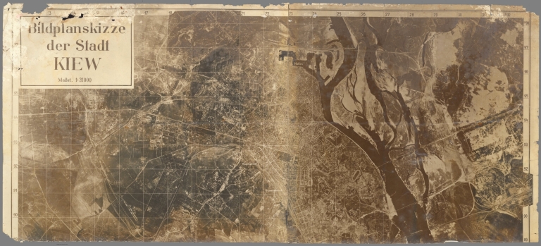
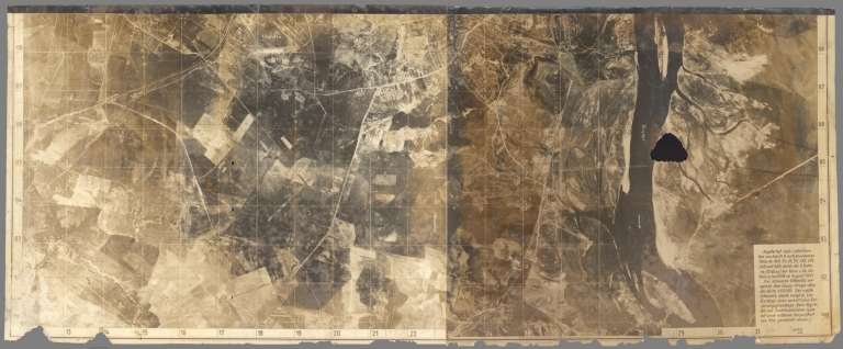
Author
Vermessungs- Und Karten-Abteilung (Mot.) 608. [German Army - Motorized Surveying & Map Detachment 608].
Full Title
Sheet 1 Bildplanskizze der Stadt Kiew 1:20 000
List No
10839.001
Author
Vermessungs- Und Karten-Abteilung (Mot.) 608. [German Army - Motorized Surveying & Map Detachment 608].
Full Title
Sheet 2 Bildplanskizze der Stadt Kiew 1:20 000
List No
10839.002
Author
Vermessungs- Und Karten-Abteilung (Mot.) 608. [German Army - Motorized Surveying & Map Detachment 608].
Full Title
Sheet 1-2 Bildplanskizze der Stadt Kiew 1:20 000
List No
10839.003
Note
Sheets 1 and 2 joined.
Author
Generalstab Des Heeres, Abteilung Für Kreigskarten Und Vermessungswesen (General Staff of the Army, Department for District Maps and Surveying
Full Title
Stadtplan von Stalingrad.
List No
10842.001
Author
Generalstab Des Heeres, Abteilung Für Kreigskarten Und Vermessungswesen (General Staff of the Army, Department for District Maps and Surveying
Full Title
Mil-Geo-Karte of Stalingrad
List No
10842.002
Author
[Oganisation Todt., Machemer, Heinrich, Schwarz, Richard]
Full Title
Der Generalinspektor für das deutsche Straẞwessen Organisation Todt / Zentrale Kraftstoff- Einsatz / Büro Dr. Machemer Berlin / Tankstellennetz Stand 1. November 1941 / Maẞtab 1:6000000. [The General Inspector for German Roadways, Organization Todt / Central Fuel Deployment / Office of Dr. Machemer, Berlin / Petrol Station Network as of November 1, 1941 / Scale 1: 6000000].
List No
10826.000
Author
Stanford, Edward, 1827-1904
Full Title
Stanford's map of the seat of war in America. London: Published by Edward Stanford, 6 Charing Cross, Oct. 1st. 1861.
List No
14278.002
Note
Hand-colored engraved military map of the eastern United States, including states bordering on west side of Mississippi River. Shows topography, lakes, drainage, bays, coastline, railroads, cities and towns, as well as political boundaries, emphasizing the delineation between "slave states" and "free states" during the Civil War. Relief shown by hachures. Includes laitudinal and longitudinal lines, a legend and a bar scale. With two inset maps: Southern part of Florida -- General map of the United States. "Sheet 1" in upper right corner. Segmented into 48 sections, mounted on folded linen. Map is 122 x 100 cm, on sheet 132 x 113 cm, folded to 22 x 15 cm. Verso has advertisements for "New atlases" and "New maps for general use" by Stanford.
Author
[Furushima, Matsunosuke, Hashimoto, Motome]
Full Title
古嶋松之助. Attack on Pearl Harbor. ハワイ大海戦図. [Hawai daikaisenzu].
List No
10806.000
Note
大日本雄辯會講談社. [Dai Nihon Yūbenkai Kōdansha]. Showa 17. 1942.
Author
News Map of the Week, Inc.
Full Title
World News of the Week : Monday, May 4, 1942. Covering period Apr. 24 to 30. Volume 4, No. 35. Published and copyrighted (weekly), 1942, by News Map of the Week, Inc., 1512 Orleans Street, Chicago, Illinois. Published in two sections : Section one. Lithographed in U. S. A.
List No
14097.000
Note
Lithographed world map, in color. Shows political boundaries and military events of World War II, from April 24 to 30, 1942. Relief illustrated with hachures. Includes a legend indicating control by the Free French and Vichy France. Descriptive text throughout, e.g.: Area subject to semi-blackout. Map indexed according to historical notes beneath map. Features photographs, illustrations, and international time zones. With inset map: The War moves northward with the sun. Also, with diagram: Factory wages; Food prices; Income taxes; Installment buying. Map is 56 x 115 cm, on sheet 89 x 120 cm, folded to 31 x 23 cm.
Author
News Map of the Week, Inc.
Full Title
World News of the Week : Monday, May 11, 1942. Covering period May 1 to 7. Volume 4, No. 36. Published and copyrighted (weekly), 1942, by News Map of the Week, Inc., 1512 Orleans Street, Chicago, Illinois. Published in two sections : Section one. Lithographed in U. S. A.
List No
14098.000
Note
Lithographed world map, in color. Shows political boundaries and military events of World War II, from May 1 to 7, 1942. Relief illustrated with hachures. Descriptive text throughout, e.g.: Where Japanese warship concentration is reported. Map indexed according to historical notes beneath map. Features photographs, illustrations, and international time zones. With eight inset maps: The Japanese Empire, Manchukuo to Corregidor : Japan, 1930 -- Japan, 1932 -- Japan, before Pearl Harbor -- Japan, Dec. 7 - Jan. 7, 1942 -- Japan, Jan. 7 - Feb. 7, 1942 -- Japan, Feb. 7 - Mar. 7, 1942 -- Japan, Mar. 7 - Apr. 7, 1942 -- Japan, April 7 to present. Map is 56 x 115 cm, on sheet 89 x 120 cm, folded to 31 x 23 cm.
Author
News Map of the Week, Inc.
Full Title
World News of the Week : Monday, May 25, 1942. Covering period May 15 to 21. Volume 4, No. 38. Published and copyrighted (weekly), 1942, by News Map of the Week, Inc., 1512 Orleans Street, Chicago, Illinois. Published in two sections : Section one. Lithographed in U. S. A.
List No
14100.000
Note
Lithographed world map, in color. Shows political boundaries and military events of World War II, from May 15 to 21, 1942. Relief illustrated with hachures. Includes a legend indicating Japanese political sovereignty. Descriptive text throughout, e.g.: Where British, French clash occurred. Map indexed according to historical notes beneath map. Features photographs, illustrations, and international time zones. With four inset maps: Principal oil fields and pipelines of the U. S. -- Martinique -- Guadeloupe -- Dakar. Map is 56 x 115 cm, on sheet 89 x 120 cm, folded to 31 x 23 cm.
Author
News Map of the Week, Inc.
Full Title
World News of the Week : Monday, June 1, 1942. Covering period May 22 to 28. Volume 4, No. 39. Published and copyrighted (weekly), 1942, by News Map of the Week, Inc., 1512 Orleans Street, Chicago, Illinois. Published in two sections : Section one. Lithographed in U. S. A.
List No
14101.000
Note
Lithographed world map, in color. Shows political boundaries and military events of World War II, from May 22 to 28, 1942. Relief illustrated with hachures. Includes a legend indicating the sale of defense bonds in the United States. Descriptive text throughout, e.g.: Territory coveted by Italy. Map indexed according to historical notes beneath map. Features photographs, illustrations, and international time zones. With two inset maps: (Asia) -- (Russia). Also, with diagram: Planes; Tanks; Guns; Ships. Map is 56 x 115 cm, on sheet 89 x 120 cm, folded to 31 x 23 cm.
Author
News Map of the Week, Inc.
Full Title
World News of the Week : Monday, June 8, 1942. Covering period May 29 to June 4. Volume 4, No. 40. Published and copyrighted (weekly), 1942, by News Map of the Week, Inc., 1512 Orleans Street, Chicago, Illinois. Published in two sections : Section one. Lithographed in U. S. A.
List No
14102.000
Note
Lithographed world map, in color. Shows political boundaries and military events of World War II, from May 29 to June 4, 1942. Relief illustrated with hachures. Includes a legend indicating U. S. and Japanese bases, as well as bombings by Japan. Descriptive text throughout, e.g.: Chinese advance here. Map indexed according to historical notes beneath map. Features photographs, illustrations, and international time zones. With two inset maps: (Libya and Egypt) -- (Crucial battleground). Also, with diagram: Per capita income in the United States. Map is 56 x 115 cm, on sheet 89 x 120 cm, folded to 31 x 23 cm.
Author
News Map of the Week, Inc.
Full Title
World News of the Week : Monday, Sept. 7, 1942. Covering period Aug. 28 to Sept. 3. Volume 5, No. 1. Published and copyrighted (weekly), 1942, by News Map of the Week, Inc., 1512 Orleans Street, Chicago, Illinois. Published in two sections : Section one. Lithographed in U. S. A.
List No
14103.000
Note
Lithographed world map, in color. Shows political boundaries and military events of World War II, from August 28 to September 3, 1942. Relief illustrated with hachures. Descriptive text throughout, e.g.: Area Reds had retaken. Map indexed according to historical notes beneath map. Features photographs, illustrations, and international time zones. With two inset maps: Islands of the Pacific pinpoint battlefronts -- The world after three years of ever-widening war. Also, with pictures of aircraft symbols. Map is 56 x 115 cm, on sheet 89 x 120 cm, folded to 31 x 23 cm.
Author
News Map of the Week, Inc.
Full Title
World News of the Week : Monday, Sept. 14, 1942. Covering period Sept. 4 to Sept. 10. Volume 5, No. 2. Published and copyrighted (weekly), 1942, by News Map of the Week, Inc., 1512 Orleans Street, Chicago, Illinois. Published in two sections : Section one. Lithographed in U. S. A.
List No
14104.000
Note
Lithographed world map, in color. Shows political boundaries and military events of World War II, from September 4 to 10, 1942. Relief illustrated with hachures. Descriptive text throughout, e.g.: Allies complete vital railroad. Map indexed according to historical notes beneath map. Features photographs, illustrations, and international time zones. With six inset maps: How warring Germany has changed the face of Europe : 1914 -- 1919 -- 1939, Mar. 22 -- 1940, Sept. 1 -- 1941, Sept. 1 -- 1942, Sept. 1. Map is 56 x 115 cm, on sheet 89 x 120 cm, folded to 31 x 23 cm.
Author
News Map of the Week, Inc.
Full Title
World News of the Week : Monday, Sept. 21, 1942. Covering period Sept. 11 to Sept. 17. Volume 5, No. 3. Published and copyrighted (weekly), 1942, by News Map of the Week, Inc., 1512 Orleans Street, Chicago, Illinois. Published in two sections : Section one. Lithographed in U. S. A.
List No
14105.000
Note
Lithographed world map, in color. Shows political boundaries and military events of World War II, from September 11 to 17, 1942. Relief illustrated with hachures. Descriptive text throughout, e.g.: Area effected by fuel ration order. Map indexed according to historical notes beneath map. Features photographs, illustrations, and international time zones. With two inset maps: (Madagascar) -- The gates of Stalingrad. Also, with diagram: Ships; Tires; Steel. Map is 56 x 115 cm, on sheet 89 x 120 cm, folded to 31 x 23 cm.
Author
News Map of the Week, Inc.
Full Title
World News of the Week : Monday, Oct. 19, 1942. Covering period Oct. 9 to Oct. 15. Volume 5, No. 7. Published and copyrighted (weekly), 1942, by News Map of the Week, Inc., 1512 Orleans Street, Chicago, Illinois. Published in two sections : Section one. Lithographed in U. S. A.
List No
14107.000
Note
Lithographed world map, in color. Shows political boundaries and military events of World War II, from October 9 to 15, 1942. Relief illustrated with hachures. Descriptive text throughout, e.g.: Reds supply city during night by boat. Map indexed according to historical notes beneath map. Features photographs, illustrations, and international time zones. With diagram: Accidents increase; Time lost is costly; Steps in a safety campaign. Map is 56 x 115 cm, on sheet 89 x 120 cm, folded to 31 x 23 cm.
Author
News Map of the Week, Inc.
Full Title
World News of the Week : Monday, Oct. 26, 1942. Covering period Oct. 16 to Oct. 22. Volume 5, No. 8. Published and copyrighted (weekly), 1942, by News Map of the Week, Inc., 1512 Orleans Street, Chicago, Illinois. Published in two sections : Section one. Lithographed in U. S. A.
List No
14108.000
Note
Lithographed world map, in color. Shows political boundaries and military events of World War II, from October 16 to 22, 1942. Relief illustrated with hachures. Descriptive text throughout, e.g.: Italians fortify Dalmation coast. Map indexed according to historical notes beneath map. Features photographs, illustrations, and international time zones. With inset map: Guadalcanal : Cockpit of the Southwest Pacific. Also, with diagram: World gold production. Map is 56 x 115 cm, on sheet 89 x 120 cm, folded to 31 x 23 cm.
Author
Gustavo Modiano & Co.
Full Title
Il Tedesco ha ordito invano la ragnatela criminosa. Gustavo Modiano & Co. Milano. Edito dall Istituto Italo-Britannico, Milano.
List No
13625.000
Author
Sundberg, Edwin L.
Full Title
Armed Truce in the Far East. News Map by staff artist Sundberg. Sunday News, September 25, 1938.
List No
13664.000
Author
Shallo, Andrew, 1922-1979
Full Title
Concept of Deterrence. Rotocomic section of The Philadelphia Inquirer, Sunday, Augus 6, 1961. Inquirer map by Andrew Shallo.
List No
13583.001
Author
Chapin, Jr., R.M.
Full Title
Russia's Ukraine. Enlargement of Original Map Drawn for Time, The Weekly Newsmagazine.
List No
10665.000
Author
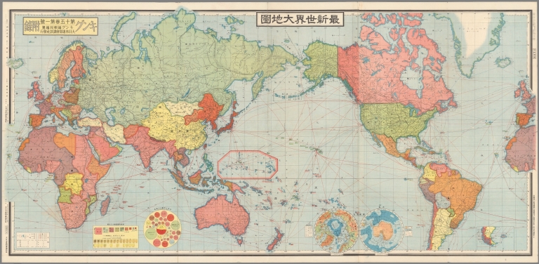
Fuchida, Tadayoshi
Full Title
最新世界大地図 = Saishin sekai daichizu. Shina zendo narabi fukin daichizu. Oshū gensei daichizu = Latest World Map. Map of the Whole of China. Current Map of Europe. Fuchida Tadayoshi. Kingu, Volume 15, no.1. Tokyo, Dainihon Yūbenkai Kōdansha, Showa 14 (1940).
List No
13462.002
Note
Color map of the world.
Author
Harrison, Richard Edes
Full Title
The physical world to the west. Richard Edes Harrison. Supplement to Fortune, January 1942, Copr. 1941 Time Inc.
List No
13491.001
Author
Charaire
Full Title
Conflit Hispano Americain : Carte du Theatre de la Guerre : Dressee Specialement pour les Lecteurs de la Depeche. Grave et imprime par Charaire, Paris, Sceaux.
List No
13520.000
Author
Hayat
Full Title
Canakkale 18 Mart 1915. Hayat : حيات (Magazine).
List No
13523.000
Author
[Martineau, Harriet, Nightingale, Florence]
Full Title
Diagram of the Causes of Mortality in the Army in the East.
List No
10563.002
Note
Colored.
Author
[Martineau, Harriet, Nightingale, Florence]
Full Title
Diagram Representing the Mortality in the Hospitals.
List No
10563.004
Note
Black and White.
Author
[Martineau, Harriet, Nightingale, Florence]
Full Title
Diagram of the Causes of Mortality in the Army in the East.
List No
10563.005
Author
Nightingale, Florence
Full Title
Army in the East.
List No
10564.003
Author
Nightingale, Florence
Full Title
Diagrams Representing the Relative Mortality from Zymotic Diseases (Blue), from Wounds &c (red), and from all other Causes (black).
List No
10564.004
Author
Nightingale, Florence
Full Title
Diagrams Constructed on the Data Furnished by the Quarter Master Generals Plans for Encampment.
List No
10564.005
Author
U.S. Atomic Energy Commission
Full Title
Atomic Airspace Reservations. PLEASE POST IN A CONSPICUOUS PLACE.
List No
10557.000
Author
News Map of the Week, Inc.
Full Title
World News of the Week : Monday, Dec. 15, 1941. Covering period Dec. 5 to Dec. 11. Volume 4, No. 15. Published and copyrighted (weekly), 1941, by News Map of the Week, Inc., 1512 Orleans Street, Chicago, Illinois. Published in two sections : Section one. Lithographed in U. S. A.
List No
14082.000
Note
Lithographed world map, in color. Shows political boundaries and military events of World War II, from December 5 to 11, 1941. Relief illustrated with hachures. Includes a legend indicating national sovereignty, including colonies. Descriptive text throughout, e.g.: Route over which Mexican forces will travel to Lower California. Map indexed according to historical notes beneath map. Features photographs, illustrations, and international time zones. With three inset maps: The Philippine Islands -- Japanese target -- Hitler's Best bets for winter. Also, with diagram: Aliens in America. Map is 56 x 115 cm, on sheet 89 x 120 cm, folded to 31 x 23 cm.
Author
News Map of the Week, Inc.
Full Title
World News of the Week : Monday, Dec. 22, 1941. Covering period Dec. 12 to Dec. 18. Volume 4, No. 16. Published and copyrighted (weekly), 1941, by News Map of the Week, Inc., 1512 Orleans Street, Chicago, Illinois. Published in two sections : Section one. Lithographed in U. S. A.
List No
14083.000
Note
Lithographed world map, in color. Shows political boundaries and military events of World War II, from December 12 to 18, 1941. Relief illustrated with hachures. Descriptive text throughout, e.g.: Tokyo reports troops landed here. Map indexed according to historical notes beneath map. Features photographs, illustrations, and international time zones. With three inset maps: (Hong Kong) -- (Tobruk) -- (World map showing Axis Powers and Allies). Also, with diagram: Comparative strength of the warring powers : Armies -- Air forces -- Navies. Map is 56 x 115 cm, on sheet 89 x 120 cm, folded to 31 x 23 cm.
Author
News Map of the Week, Inc.
Full Title
World News of the Week : Monday, Jan. 12, 1942. Covering period Jan. 2 to Jan. 8. Volume 4, No. 19. Published and copyrighted (weekly), 1942, by News Map of the Week, Inc., 1512 Orleans Street, Chicago, Illinois. Published in two sections : Section one. Lithographed in U. S. A.
List No
14084.000
Note
Lithographed world map, in color. Shows political boundaries and military events of World War II, from January 2 to 8, 1942. Relief illustrated with hachures. Descriptive text throughout, e.g.: British take total of 7,000 prisoners here. Map indexed according to historical notes beneath map. Features photographs, illustrations, and international time zones. With four inset maps: The fortress of Corregidor Island -- (Br. Malaya) -- Where U. S. trains troops for war -- Highlights of the War in 1941. Also, with diagram: U. S. donations for war relief. Map is 56 x 115 cm, on sheet 89 x 120 cm, folded to 31 x 23 cm.
Author
News Map of the Week, Inc.
Full Title
World News of the Week : Monday, Jan. 19, 1942. Covering period Jan. 9 to Jan. 15. Volume 4, No. 20. Published and copyrighted (weekly), 1942, by News Map of the Week, Inc., 1512 Orleans Street, Chicago, Illinois. Published in two sections : Section one. Lithographed in U. S. A.
List No
14085.000
Note
Lithographed world map, in color. Shows political boundaries and military events of World War II, from January 9 to 15, 1942. Relief illustrated with hachures. Descriptive text throughout, e.g.: Australian Navy Minister says U. S. British reinforcements on way east. Map indexed according to historical notes beneath map. Features photographs, illustrations, and international time zones. With two inset maps: Enemy's industries -- (Manila Bay). Also, with three diagrams: Japanese naval losses in the Far East -- 1943 Budget; U. S. Budget; Defense; Public Debt -- U. S. Army Strength. Map is 56 x 115 cm, on sheet 89 x 120 cm, folded to 31 x 23 cm.
Author
News Map of the Week, Inc.
Full Title
World News of the Week : Monday, Jan. 26, 1942. Covering period Jan. 16 to Jan. 22. Volume 4, No. 21. Published and copyrighted (weekly), 1942, by News Map of the Week, Inc., 1512 Orleans Street, Chicago, Illinois. Published in two sections : Section one. Lithographed in U. S. A.
List No
14086.000
Note
Lithographed world map, in color. Shows political boundaries and military events of World War II, from January 16 to 22, 1942. Relief illustrated with hachures. Descriptive text throughout, e.g.: Dutch Islands being guarded by U. S. Air Force. Map indexed according to historical notes beneath map. Features photographs, illustrations, and international time zones. With two inset maps: Malay States -- When the Allies attack Japan. Also, with diagram: Average hourly wage rates in manufacturing industry. Map is 56 x 115 cm, on sheet 89 x 120 cm, folded to 31 x 23 cm.
Author
Voute, Kathleen
Full Title
The battle map of history and story. Kathleen Voute, cartographer. Copyrighted 1940 by R. R. Bowker Co.
List No
14073.000
Note
Pictorial military map of the world, in color. Shows battle sites, with historical notes, such as: Wyoming Massacre, 1778. Includes a compass rose, illustrations of historical figures throughout, vignettes of battle scenes beneath map, and decorative cartouche with flags, as well as decorative border, which lists historic military leaders. With 4 insets: Battles of Indian Wars, American Revolution and War of 1812 -- Battlefields of France and Belgium in many wars -- American Revolution, War of 1812 and War between states -- Battles of ancient and modern Italy & Greece. Map is 49 x 78 cm, on sheet 58 x 88 cm.
Author
Blake, F. Donald
Full Title
Britain - Spearhead of attack. F. Donald Blake. Printed in England by Alf Cooke Ltd., Leeds and London.
List No
14074.000
Note
Pictorial military map of the Great Britain, and part of Europe. Shows battle sites and locations of resources, such as electric power, coal and tanks. Includes a legend and descriptive text, as well as a decorative title cartouche. With inset: (Turin; Milan; Genoa). Map is 45 x 70 cm, on sheet 51 x 76 cm. For Italian edition of map in Collection, see Pub List No. 14075.000. (Date estimated.)
Author
Blake, F. Donald
Full Title
Gran Bretagna - la posizione avanzata dell'attacco. F. Donald Blake. (Printed in England by Alf Cooke Ltd., Leeds and London.)
List No
14075.000
Note
Pictorial military map of the Great Britain, and part of Europe. Shows battle sites and locations of resources, such as electric power, coal and tanks. Includes a legend and descriptive text, as well as a decorative title cartouche. With inset: (Turin; Milan; Genoa). Map is 45 x 70 cm, on sheet 51 x 76 cm. For English edition of map in Collection, see Pub List No. 14074.000. (Imprint taken from 14074.000. Date estimated.)
Author
Fraser, Eric (1902-1983)
Full Title
Dupuis Plus De Deux Siecles Les Flottes Britanniques Ont Aide A Assuber Dans Tous Les Oceans La Securite D'Un Pacifique Commerce Entre Les Nations. (For More Than Two Centuries The British Fleets Have Helped Ensure The Security Of A Pacific Trade Between The Nations)
List No
10474.000
Note
The map shows how the British fleets, including those of Commonwealth Countries, have provided security for Britain and its allies around the world. The note in the box on the left side of the map goes on to say "The flags indicate the main ports and harbors of the Royal Navy, the Royal Australian Navy, the Royal Canadian Navy, the Royal New Zealand Navy, the Royal Indian Navy and the South African Navy-fleets of the Commonwealth of British nations which, in all parts of the globe, are united in a common front against units of aggression."
Author
Stichting 1940-1945
Full Title
1940-1945. Nederland in oorlogstijd. Stichting 1940-1945. Heerengracht 595 Amsterdam.
List No
13415.000
Author
W. & A.K. Johnston
Full Title
(Covers to) Johnstons' atlas of the war. W. & A.K. Johnston. Geographer & Engravers to the Queen. Edinburgh. 1854-1855.
List No
8367.001
Note
7 color maps in slip case, on sheets 53.5x69, or 69x53.5. Each map individually titled, folded into self wrapped cover, placed into red card board slip case, 23.5x14, with manuscript list of maps. Maps showing railways, fortified places, major cities, towns and villages, principal roads, railroads, churches, etc. Includes descriptive and dated notes, statistical tables. Relief shown by hachures. Prime meridian is Greenwich. Map of Southern Russia, 1855. Danubian Principalities & Turkey 1854. Chart of the Baltic Sea Cronstadt &c. Map of the Crimea, 1855. Map of the Black Sea 1855. Plan of the Siege of Sevastopol. Chart of the Sea of Azov. 1855.
Author
W. & A.K. Johnston
Full Title
(Covers to) Johnstons' new map of the seat of war in the Danubian prinicipalities and Turkey with the adjoining countries. With map of central Europe, 1854. Tenth edition. W. & A.K. Johnston. Geographer & Engravers to the Queen, 4 St. Andrew Square, Edinburgh. (to accompany) Johnstons' atlas of the war-1855.
List No
8367.002
Note
Cover to fold out map.
Author
W. & A.K. Johnston
Full Title
Johnstons' new map of the seat of war in the Danubian prinicipalities and Turkey with the adjoining countries. With map of central Europe, 1854. W. & A.K. Johnston. Geographer & Engravers to the Queen, Edinburgh. (to accompany) Johnstons' atlas of the war-1855.
List No
8367.003
Note
Hand color map. Showing railways, fortified places, major cities, towns and villages, roads, churches, etc. Includes explanation and notes. Relief shown by hachures. Prime meridian is Greenwich.
Author
W. & A.K. Johnston
Full Title
(Covers to) Johnston's Chart of the Baltic Sea, German Ocean & English Channel. With the adjoining countries : Showing principal lines of railway communication to the coasts of Northern Europe, with enlarged plans of Cronstadt, Sveaborg, Revel, Port Baltic & Gulf of Riga. 1855 -- W. & A.K. Johnston, Geographer & Engraver to the Queen, 4 St. Andrew Square, Edinburgh. (to accompany) Johnstons' atlas of the war-1855.
List No
8367.004
Note
Cover to fold out map.
Author
W. & A.K. Johnston
Full Title
Johnston's Chart of the Baltic Sea, German Ocean & Englis h Channel. With the adjoining countries : Showing principal lines of railway communication to the coasts of Northern Europe. 1855. W. & A.K. Johnston, Engraver & Geographer to the Queen, Edinburgh. (to accompany) Johnstons' atlas of the war-1855. (6 insets).
List No
8367.005
Note
Hand color map. Insets: Gulf of Bothnia, Revel or Reval, Sveaborg, Cronstadt, Port of Baltic, and Enlarged plan of the Gulf of Riga, with the Islands of Osel, Dago &c. Showing major cities, towns and villages, roads, railroads, fortified places, tracks, churches, etc. Includes explanation and notes. Relief shown by hachures. Prime meridian is Greenwich.
Author
W. & A.K. Johnston
Full Title
(Covers to) Johnstons' New map of the Crimea : with a plan of the town and port of Eupatoria and a sketch map shewing the relative position of the Crimea with the seat of war in the east, 1855 -- W. & A.K. Johnston. Geographer & Engravers to the Queen, 4 St. Andrew Square, Edinburgh. (to accompany) Johnstons' atlas of the war-1855.
List No
8367.006
Note
Cover to fold out map.
Author
W. & A.K. Johnston
Full Title
Johnstons' New map of the Crimea Eupatoria &c. W. & A.K. Johnston, Engraver & Geographer to the Queen, Edinburgh. (to accompany) Johnstons' atlas of the war-1855. (insets) Sketch of Koslov or Eupatoria : Showing its batteries & works of defence from Admiralty Survey, 1855. (with) Map shewing the relative position of the Crimea with the seat of war.
List No
8367.007
Note
Hand color map. Showing fortified places, major cities, towns and villages, roads, tracks, churches, etc. Includes explanation and notes. Relief shown by hachures. Prime meridian is Greenwich.
Author
W. & A.K. Johnston
Full Title
(Covers to) Johnstons' New map of the Black Sea, Caucasus, Crimea & c : with enlarged plans of Sevastopol as seen by the officers of H.M.S.F. Retribution 6th. January 1854 and the Bosporus, 1854 -- W. & A.K. Johnston. Geographer & Engravers to the Queen, 4 St. Andrew Square, Edinburgh. (to accompany) Johnstons' atlas of the war-1855.
List No
8367.008
Note
Cover to fold out map.
Author
W. & A.K. Johnston
Full Title
Johnstons' New map of the Black Sea, Caucasus, Crimea & c. 1854. W. & A.K. Johnston. Engravers & Geographer to the Queen, Edinburgh. (insets) Enlarged plan of Bosporus. (with) Harbour of Sevastopol. (to accompany) Johnstons' atlas of the war-1855.
List No
8367.009
Note
Color map. Showing fortified places, major cities, towns and villages, roads, etc. Includes explanation and notes. Relief shown by hachures. Prime meridian is Greenwich.
Author
W. & A.K. Johnston
Full Title
(Covers to) Johnstons' Plan of the siege of Sevastopol : showing the positions of the Allied & Russian Armies from the Admiarlty Surveys. April 1855. -- W. & A.K. Johnston. Geographer & Engravers to the Queen, 4 St. Andrew Square, Edinburgh. (to accompany) Johnstons' atlas of the war-1855.
List No
8367.010
Note
Cover to fold out map.
Author
W. & A.K. Johnston
Full Title
Johnstons' Plan of the siege of Sevastopol : showing the positions of the Allied & Russian Armies from the Admiarlty Surveys. April 1855. -- W. & A.K. Johnston. Edinburgh. Engravers & Geographer to the Queen. (to accompany) Johnstons' atlas of the war-1855. (inset) View of Sevastopol.
List No
8367.011
Note
Hand color map. Showing railways, fortified places, major cities, towns and villages, roads, churches, etc. Includes explanation and notes. Relief shown by hachures. Prime meridian is Greenwich.
Author
W. & A.K. Johnston
Full Title
(Covers to) Johnstons' chart of the Sea of Azov, with a map of the grain producing portion of Russia whence it derives ut commerce. 1855 -- W. & A.K. Johnston, Geographer & Engraver to the Queen, 4 St. Andrew Square, Edinburgh. (to accompany) Johnstons' atlas of the war-1855. .
List No
8367.012
Note
Cover to fold out map.
Author
W. & A.K. Johnston
Full Title
Johnstons' chart of the Sea of Azov, with a map of the grain producing portion of Russia whence it derives ut commerce. W. & A.K. Johnston, Engraver & Geographer to the Queen, Edinburgh. (to accompany) Johnstons' atlas of the war-1855. (inset) Map of Southern Russia
List No
8367.013
Note
Hand color map. Showing major cities, towns and villages, roads, railroads, fortified places, tracks, etc. Includes descriptive and statistical notes. Prime meridian is Greenwich.
Author
W. & A.K. Johnston
Full Title
(Covers to) Johnstons' map of Southern Russia : extending from Kinburn to Kief and from Mohilev to Berdinsk. 1855 -- W. & A.K. Johnston, Geographer & Engraver to the Queen, 4 St. Andrew Square, Edinburgh. (to accompany) Johnstons' atlas of the war-1855.
List No
8367.014
Note
Cover to fold out map.
Author
W. & A.K. Johnston
Full Title
Johnstons' map of Southern Russia. W. & A.K. Johnston, Engraver & Geographer to the Queen, Edinburgh. (to accompany) Johnstons' atlas of the war-1855. .
List No
8367.015
Note
Hand color map. Showing cattle rearing, and Grain producing districts, major cities, towns and villages, roads, tracks, churches, etc. Includes explanation and notes. Prime meridian is Greenwich.
Author
Mercier, Jacques
Full Title
Le front de l'Ocean. Jac Mercier. dessinateur.
List No
13400.000
Note
Dated 31-3-42
Author
[Star, Silva, J.R.]
Full Title
Mapa Humoristico da Europa em 1953. Star. Edicao de: J.R. Silva.
List No
13385.000
Author
Jourdan, Emilio Carlos, 1838-1900
Full Title
Povo de Abegua. Villa du Lucque com os acampamtos. do 2º Corpo ... Lith. Imp. de Ed. Rensburg. Rio De Janeiro. (to accompany) Atlas historico da guerra do Paraguay ... Rio de Janeiro - 1871.
List No
13380.019
Note
11 map and 2 views on 1 sheet. Including: Povo de Abegua. Villa du Lucque. Cidade de Assumpçao durante a occupacao do Exercito alliado 1869-70. Capella do Sao-Lourenço. Paraguari. Villa de Itacua. Minas de Enxofre entre Itacuruby e Valenzuela. Caraguatary. Jaguarao. Valenzuela. Barreiro-Grande. And 2 views: 1. Palacio do Presidente Lopes em Assumpcao. 2. Interior da Igreja de Humaitá depois do bombardeamento.
Author
Jourdan, Emilio Carlos, 1838-1900
Full Title
(Composite Map) Planta da Republica do Paraguay : Com as marchas dos Exercitos alliados en 1866-67-68-69-70. Lith. Imp. de Ed. Rensburg. Rio De Janeiro. (to accompany) Atlas historico da guerra do Paraguay ... Rio de Janeiro - 1871.
List No
13380.023
Note
Composite map of sheets 16-17 of Planta da Republica do Paraguay.
Author
Donnet, Alejo
Full Title
(Composite Map) Mapa Civil y Militar de Espana y Portugal, con la nueva Division en distritos. Enrique cido de los planes particulares de 34 Ciudades y puertos principales : Dedicado a las Heroicas Naciones Espanolas y Portuguesas por los editores Dauty y Malo ... Por don Alejo Donnet ... Grabado por los hermanos Malo discipulos del Real Deposito de la guerra de Francia. 1823. Abel Malo Sculp. Publicado en Paris, Pour Dauty Editor de Estampas en el Palacio Real, Galeria de Nemours : Malo, el mayor grabador, Calle des Gres no. 10. De l'Imprimerie d' Auguste Malo.
List No
13386.007
Note
composite map of Sheet 1-6. Mapa Civil y Militar de Espana y Portugal.
Author
Donnet, Alejo
Full Title
Mapa Civil y Militar de Espana y Portugal, con la nueva Division en distritos. Enrique cido de los planes particulares de 34 Ciudades y puertos principales : Dedicado a las Heroicas Naciones Espanolas y Portuguesas por los editores Dauty y Malo ... Por don Alejo Donnet ... Grabado por los hermanos Malo discipulos del Real Deposito de la guerra de Francia. 1823. Abel Malo Sculp. Publicado en Paris, Pour Dauty Editor de Estampas en el Palacio Real, Galeria de Nemours : Malo, el mayor grabador, Calle des Gres no. 10. De l'Imprimerie d' Auguste Malo.
List No
13386.001
Author
Donnet, Alejo
Full Title
Mapa Civil y Militar de Espana y Portugal, con la nueva Division en distritos. Enrique cido de los planes particulares de 34 Ciudades y puertos principales : Dedicado a las Heroicas Naciones Espanolas y Portuguesas por los editores Dauty y Malo ... Por don Alejo Donnet ... Grabado por los hermanos Malo discipulos del Real Deposito de la guerra de Francia. 1823. Abel Malo Sculp. Publicado en Paris, Pour Dauty Editor de Estampas en el Palacio Real, Galeria de Nemours : Malo, el mayor grabador, Calle des Gres no. 10. De l'Imprimerie d' Auguste Malo.
List No
13386.002
Author
Donnet, Alejo
Full Title
Mapa Civil y Militar de Espana y Portugal, con la nueva Division en distritos. Enrique cido de los planes particulares de 34 Ciudades y puertos principales : Dedicado a las Heroicas Naciones Espanolas y Portuguesas por los editores Dauty y Malo ... Por don Alejo Donnet ... Grabado por los hermanos Malo discipulos del Real Deposito de la guerra de Francia. 1823. Abel Malo Sculp. Publicado en Paris, Pour Dauty Editor de Estampas en el Palacio Real, Galeria de Nemours : Malo, el mayor grabador, Calle des Gres no. 10. De l'Imprimerie d' Auguste Malo.
List No
13386.003
Author
Donnet, Alejo
Full Title
Mapa Civil y Militar de Espana y Portugal, con la nueva Division en distritos. Enrique cido de los planes particulares de 34 Ciudades y puertos principales : Dedicado a las Heroicas Naciones Espanolas y Portuguesas por los editores Dauty y Malo ... Por don Alejo Donnet ... Grabado por los hermanos Malo discipulos del Real Deposito de la guerra de Francia. 1823. Abel Malo Sculp. Publicado en Paris, Pour Dauty Editor de Estampas en el Palacio Real, Galeria de Nemours : Malo, el mayor grabador, Calle des Gres no. 10. De l'Imprimerie d' Auguste Malo.
List No
13386.004
Note
Includes table.
Author
Donnet, Alejo
Full Title
Mapa Civil y Militar de Espana y Portugal, con la nueva Division en distritos. Enrique cido de los planes particulares de 34 Ciudades y puertos principales : Dedicado a las Heroicas Naciones Espanolas y Portuguesas por los editores Dauty y Malo ... Por don Alejo Donnet ... Grabado por los hermanos Malo discipulos del Real Deposito de la guerra de Francia. 1823. Abel Malo Sculp. Publicado en Paris, Pour Dauty Editor de Estampas en el Palacio Real, Galeria de Nemours : Malo, el mayor grabador, Calle des Gres no. 10. De l'Imprimerie d' Auguste Malo.
List No
13386.005
Note
Includes insets and profiles.
Author
Donnet, Alejo
Full Title
Mapa Civil y Militar de Espana y Portugal, con la nueva Division en distritos. Enrique cido de los planes particulares de 34 Ciudades y puertos principales : Dedicado a las Heroicas Naciones Espanolas y Portuguesas por los editores Dauty y Malo ... Por don Alejo Donnet ... Grabado por los hermanos Malo discipulos del Real Deposito de la guerra de Francia. 1823. Abel Malo Sculp. Publicado en Paris, Pour Dauty Editor de Estampas en el Palacio Real, Galeria de Nemours : Malo, el mayor grabador, Calle des Gres no. 10. De l'Imprimerie d' Auguste Malo.
List No
13386.006
Note
Map and title. Includes insets
Author
Means, Elliott Anderson
Full Title
38,000,000 escaped -- 10,000,000 died. E. Means. Russian War Relief, Inc., 11 E. 35th St., New York City.
List No
13286.000
Author
Aguiar, Antonio Nunes de
Full Title
Carta do territorio da Republica do Paraguay : onde se dera as batalhas entre o exercito desta Republica e os das nacoes alliadas, Imperio do Brazil, Confederaçao Argentina e Republica de Uruguay, desde 1866 ate 1870; Confeccionada por proposta approvada por Avizo do Ministerio da Guerra de 3 Setembro de 1869, do Commandante Geral do Corpo de Engenheiros Marechal de Campo, Conselheiro de Guerra, Antonio Nunes de Aguiar ... Exercito Brazileiro e dos mappas publicados no Estrangeiro axistentes no mesmo Archivo Militar. 1871. Lithogaphia do Archivo Militar.
List No
13292.000
Note
"Monumental Brazilian Wall Map from the War of the Triple Alliance Remarkable map of Paraguay prepared by the Brazilian Military in Rio de Janeiro during the War of the Triple Alliance. The large map shows the major campaigns which led to a Brazilian/Argentine/Uruguayan victory and the destruction of Paraguay’s economy and army. The title of the map reads: Carta do territorio da Republica do Paraguay, onde se derão as batalhas entre o exercito desta Republica e os das naçōes alliadas, Imperio do Brazil, Confederação Argentina e Republica do Uruguay, desde 1866 até 1870; confeccionada por proposta approvada por avizo do Ministerio da Guerra de 3 de setembro de 1869, do Commandante Geral do Corpo de Engenheiros, Marechal de Campo, Conselheiro de Guerra Antonio Nunes de Aguiar, pelos officiaes empregados no Archivo Militar. Translation: Map of the territory of the Republic of Paraguay, showing the battles between the Army of this Republic and those of the allied nations, the Empire of Brazil, the Confederation of Argentina and the Republic of Uruguay, from 1866 to 1870; prepared by a proposal approved by the Ministry of War on September 3, 1869, of the Commandant General of the Corps of Engineers, Field Marshal, War Adviser Antonio Nunes de Aguiar, by the officers employed in the Military Archive. This map, then, can be seen as the official Brazilian record of a war that they ultimately won. It was printed by the Lithography Office of the Military Archive. As the title explains, it was based on new information gathered by the Brazilian Army during the war and the most up-to-date foreign maps available in the Military Archive’s collection. The map shows a detailed rendering of the topography of the region. Rivers, lakes, roads, and settlements, particularly Jesuit missions, are carefully labeled. Dotted lines show the various marches undertaken by armies during the war, but perhaps the most distinct features of the map are the tiny crossed swords that dot the terrain. These swords, and their corresponding numbers, mark the battle sites where Paraguayans clashed with allied forces in the War of the Triple Alliance. These battles are listed chronologically in a legend to the left, just below the title. They date from between April 10, 1866 and March 1, 1870. The War of the Triple Alliance The War of the Triple Alliance, also known as the Paraguayan War or, in Paraguay, the Great War, was the bloodiest inter-state conflict ever to take place in Latin America. While estimates vary and cause considerable contention, it is thought that 60%, and possibly more, of Paraguay’s population was wiped out. The hundreds of thousands of men who lived in Paraguay prior to the war were reduced to only 28,000, as much as a 90% loss. Border disputes in the region were nothing new by the 1860s. Spain and Portugal had fought over the precise location of the frontier between their empires since the fifteenth century. After the Latin American states gained their independence in the early nineteenth century, the new nations inherited the disputes that concentrated in the Rio de la Plata basin, which is where Paraguay, Uruguay, Brazil, and Argentina all converge. A catalyst for the War of the Triple Alliance was Brazil’s interference in a Uruguayan civil war in 1864. Emperor Pedro II wanted to ensure that his preferred Colorado Party prevailed; with Brazilian aid they did and the Colorados continued to rule Uruguayan politics uninterrupted until the 1950s. Paraguay’s leader, Francisco Solano López, had supported the other contender, the Blanco Party, and saw Brazil’s interference as a dangerous precedent that undermined Paraguayan sovereignty and the regional balance of power. López’s father, Carlos Antonio López, had begun Paraguay’s accelerated industrialization in the decades prior to the war. Paraguay had one of the first railways in South America and revenue came from a shipyard and a large foundry. At the time, the only way for freight and people to travel south from Brazil was to navigate the Paraguay River, further enhancing the nation’s importance. In response to the Brazilian aggression in Uruguay, López threatened to unleash his army, which, thanks to conscription, included every man of fighting age in Paraguay. When Pedro II did not back down, López attacked Mato Grosso, to the north of the area shown on this map. On May 1, 1865, the president of Argentina, Bartolomé Mitre, signed an alliance consisting of Brazil, Argentina, and Uruguay, which was now controlled by the Colorados. These three combatants formed the eponymous Triple Alliance. Although the alliance outnumbered Paraguay’s population 25 to 1, López had amassed a powerful, if antiquely provisioned, army. In 1865, López’s forces made early gains. They advanced in both Uruguay and Brazil, but soon had to withdraw due to logistical problems and the amassing of the Allied Army. In June of that year, the Brazilian Navy defeated the Paraguayans at Riachuelo, opening the way for a blockade of Paraguay’s rivers. The landlocked country was now cut off from the outside world. López and the Paraguayan army did not surrender, however. Instead, they entrenched themselves and expanded the draft to include all men, leaving few to work the fields and causing many to starve. It is during this period, 1866-70, that the battles listed on this map took place. Farther south, in 1868, the allied troops under the Brazilian marquês de Caxias, took the crucial fortifications at Humaitá; this opened the way to the capital, Asunción. In December of 1868, at the Battle of Lomas Valentinas near Asunción, the balance of the Paraguayan army was defeated. This is battle 34 listed in the legend to the left. López fled north, where he would be killed at the Battle of Cerro Cará on March 1, 1870. This is the final battle included on the map, number 50. Paraguay was utterly devastated by the war—politically, economically, and demographically. The country lost territory to Brazil and Argentina. The allies continued to occupy the country until 1876 and levied a large indemnity on the nation (which was never paid). Even today, Paraguayan politics and economics refer to and are impacted by the outcome of the War of the Triple Alliance. Rarity This map is extremely rare. OCLC locates only the example in the National Library of Spain. We also note a copy referenced in Philips (Checklist of Large Scale Maps Published by Foreign Governments, p. 55 Library of Congress, 1904). Provenance The map was originally acquired by the French Embassy at the Palais Beauvryé in Berlin, as noted by the elaborate contemporary manuscript note on the verso (Department des Affaires Etrangeres de l'Empir Germanique a Berlin). Thereafter, several stamps reflect ownership by German archives. Quite likely, the map was in the French Foreign Office during the time Count Vincent Benedetti (1817-1900) was serving as French Ambassador to Prussia. The map probably remained there until the outbreak of the Franco-Prussian War in 1870. The collection from which the map came was likely resident in East Germany after World War II." (Ruderman)
Author
Cavalleri, Giovanni Battista
Full Title
Descrittione della Terra, et Castello di Dieppa, Ascediata dal Sigr. Duca d'Humena. Descrittione dell' esercito de Catolici accampato tra il Castello d'Arques et la Terra di Dieppa et batteria d 24 Canoni et 12 Collumbrine, Intagliata per GiovanBatista de Cavallieri. in Roma Ianno 1589.
List No
13280.000
Author
Hellert, J. J.
Full Title
Siege de Vienne par Souleiman I : Du 27 Septembre au 14 Octobre 1529 (23 Moharrem au 10 Safer 935). Grave par par U. Muschani. Imprime chez Thierry Freres. Atlas de l'Empire Ottoman, par J.J. Hellert. Planche XXXV. (to accompany) Nouvel atlas physique, politique, et historique de l'Empire Ottoman... 1844.
List No
13229.044
Note
Engraved plan of the Siege of Vienna. Includes explanation. Map showing fortifications, roads and rivers. Relief shown by hachures and form lines.
Author
Hellert, J. J.
Full Title
Plan de Constantinople et de ses faubourgs, a'aprees Kauffer, Le Chevalier, Barbiedu Bocage, et J. Hammer. Par J. Hellert. Paris 1843. Grave par par U. Muschani. Imprime chez Thierry Freres, Paris. Atlas de l'Empire Ottoman, par J.J. Hellert. Planche XXXVII. (to accompany) Nouvel atlas physique, politique, et historique de l'Empire Ottoman... 1844.
List No
13229.046
Note
Engraved folded Plan of Istanbul and its environs. Showing the changes which have been made since the years 1776 and 1786 until the year 1831. Includes index to suburbs and quarters (Mahalles).
Author
Des Barres, Joseph F. W. (Joseph Frederick Wallet), 1722-1824
Full Title
(Chart of Boston Harbor and the surrounding area)
List No
10278.000
Note
"De Barres' remarkable chart of Boston Harbor is a highly important Revolutionary War map depicting details relating to the Siege of Boston. This is one the most important maps contained in Des Barres' Atlantic Neptune, and one of the most significant maps of the Revolutionary War. The map provides a meticulous record of Boston at the beginning of the war, covering the area from the environs of the city out into the open waters of Massachusetts Bay. The map is a working sea-chart, focused upon features such as depth soundings, indicated by detailed lines and based on surveys by Samuel Holland and George Callendar, and the navigable channels between the harbor's numerous shoals, which are delicately outlined in stipple-engraving. Holland's original manuscript map is today preserved in the British Hydrographic Library at Taunton, Somerset. The present map shows the city of Boston, with its streets carefully outlined, occupying a pear-shaped peninsula, a position that would soon prove precarious to its British defenders in the escalating conflict. Joseph Frederick Wallet Des Barres was born in Switzerland, where his Huguenot ancestors had fled following the repeal of the Edict of Nantes. He studied under the great mathematician Daniel Bernoulli at the University of Basel, before immigrating to Britain, where he trained at the Royal Military College, Woolwich. Upon the outbreak of hostilities with France in 1756, he joined the British Royal American Regiment as a military engineer. He came to the attention of General James Wolfe, who appointed him to join his personal detail. During this period he also worked with the legendary future explorer James Cook on a monumental chart of the St. Lawrence River. Upon the conclusion of the Seven Years War, Britain's empire in North America was greatly expanded, and this required the creation of a master atlas featuring new and accurate sea charts for use by the Royal Navy. Des Barres was enlisted to survey the coastlines of Nova Scotia, Newfoundland, and the Gulf of St. Lawrence. With these extremely accurate surveys in hand, Des Barres returned to London in 1774, where the Royal Navy charged him with the Herculean task of producing the atlas. He was gradually forwarded the manuscripts of numerous advanced surveys conducted by British cartographers in the American Colonies, Jamaica and Cuba, of which the present map is based on the work of Samuel Holland, conducted in the 1760s. The result was The Atlantic Neptune, which became the most celebrated sea atlas of its era, containing the first systematic survey of the east coast of North America. Des Barres's synergy of great empirical accuracy with the peerless artistic virtue of his aquatint views, created a work that "has been described as the most splendid collection of charts, plates and views ever published" ( National Maritime Museum Catalogue). ' The Neptune eventually consisted of four volumes and Des Barres's dedication to the project was so strong that often at his own expense he continually updated and added new charts and views to various editions up until 1784, producing over 250 charts and views, many appearing in several variations. All of these charts were immensely detailed, featuring both hydrographical and topographical information, such that in many cases they remained the most authoritative maps of the regions covered for several decades. Following the completion of The Neptune, Des Barres returned to Canada, where he remained for a further forty years, becoming a senior political figure and a wealthy land owner, living to the advanced age of 103." Ruderman.
Author
Burke, Howard
Full Title
Pictorial Review : San Francisco Examiner Sunday, Oct. 20, 1940. Rich Dutch Colonies at Stake. Will Japan Try to Take Them? Will the United States Defend Them?. Howard Burke.
List No
13175.000
Note
Color pictorial map, front page of the San Francisco Examiner Pictorial Review section. Illustrated by Howard Burke, focuses on eastern hemisphere, with bird's eye view inset map of Singapore and a vignette illustration at the lower left corner of elephants and temple. Japan and Japanese occupied areas are shown in red. Includes informative text and small pictographs provide an effective overview of the geopolitical situation. Includes legend. Relief shown pictorially.
Author
Burke, Howard
Full Title
Los Angeles Examiner. Tuesday, September 29, 1942 : Tokyo's Next Bombing May Come From Vladivostok. Howard Burke.
List No
13178.000
Note
Color map from the Los Angeles Examiner Pictorial Review section, Sept. 29, 1942. Illustrated by Howard Burke. With 2 inset maps: Manchukuo and Soviet Russia. Shows battle fields, naval and air force areas, roads and railroads. Includes informative text and overview of the geopolitical situation of the area.
Author
Herald American
Full Title
Pictorial Review. Herald American, Sec. IV- Sunday August 1942. New World Map Shows Vital Importance of Alaska -- (See Page 2). This is a reduced copy of the polar (Casson) Projection Map of the World ... Copyright by the Universal Map Co., Inc. New York, N.Y.
List No
13180.000
Note
Color map from Herald American Pictorial Review August 1942. with 6 insets. The polar projection of this map effectively shows the proximity of Alaska and the Asian theater of war. " The Second World War saw a revival in popular interest in geography and maps; this interest was further fueled by the new "aviation era" maps produced by mapmakers such as Richard Edes Harrison, and their inclusion in newspapers around the States.
Author
Burke, Howard
Full Title
Kiska Seen as Key Base to Attack Paramushiro, Japan. Pictorial review : Los Angeles Examiner, August 10, 1943. Howard Burke.
List No
13181.000
Note
Color pictorial map from the Los Angeles Examiner Pictorial Review section, by Los Angeles Examiner artist Howard Burke. Published by Los Angeles Examiner. Los Angeles. 08-10- 1943. Showing a bird's eye view of Kiska Island. Depicts fighter jets with naval bases. Text at lower right provides an overview of the strategic location of the island.
Author
Morrell, G. F.
Full Title
"The Graphic" map of the Dardanelles operations. G. F. Morrell. (cover title) "The Graphic" Pictorial presentation of the Dardanelles campaign.
List No
13195.002
Note
Pictorial relief map of the Gallipoli peninsula, folding in envelope 32x23, with printed title and price. Relief shown pictorially and spot height in feet. Map includes notations. Text on bottom of map has caption: Battering at the gate to Constantinople: the progress of the allied naval and military forces at the Dardanelles. Map includes information on the landings and the battles of the operations.
Author
Juarez, Manual Angel
Full Title
Mapa del puerto de Gibraltar.
List No
13196.000
Note
Woodcut map with decorative border. Publisher: En Sevilla en casa de Manuel Angel Juarez, Mercader de libros junto a la Real Academia. Shows landmarks, buildings and battleships. Relief shown pictorially. It represents the Franco-Spanish siege of Gibraltar from 1704-1705. Includes title cartouche, arms of Philip V, the Bourbon King of Spain, compass rose in the center, legend in the lower left and text at the foot of map. Principal buildings and other points of interest represented pictorially and numbered, corresponding with the legend in the lower left corner. The title is contained within a banderole, flanked by the arms of Philip V, the Bourbon King of Spain, and the town of Gibraltar. This is a broadsheet plan of the unsuccessful Franco-Spanish siege of Gibraltar from 1704-1705, which followed the capture of Gibraltar by an Anglo-Dutch fleet during the War of Spanish Succession. The map shows the first and second lines of trenches established by the Marquis of Villadarias, who was replaced in February 1705 by the French Marshal de Tessé, and Worldcat suggests a date of 1705. However, the history of Gibraltar at the foot of map concludes with the Anglo-Dutch capture in August 1704, and notes that it has been in the hands of the English and others for two years; Gibraltar was technically captured on behalf of Archduke Charles, the Bourbon claimant of the Spanish throne. Scarce. Worldcat locates a single example in the Biblioteca Nacional de España, Madrid, which appears to have been bound into a composite ‘Atlas de mapas realizados por cartógrafos franceses’. OCLC 894642244.
Author
Luffman, John, 1756-1846
Full Title
Cadiz Harbour. Engraved for Luffman's Select plans of the principal cities, ports, harbours, forts, &c. in the world. London, - Engraved and published July 1. 1799, by John Luffman.
List No
13189.003
Note
Hand colored chart. Relief shown by hachures. Depth shown by soundings. Includes historical text at the foot of map.
Author
Luffman, John, 1756-1846
Full Title
Port Royal in Jamaica. Engraved for Luffman's Select plans of the principal cities, ports, harbours, forts, &c. in the world. London, - Engraved and published July 1. 1799, by John Luffman.
List No
13189.005
Note
Hand colored chart. Relief shown by hachures. Depth shown by soundings. Prime meridian is London. Includes historical text at the foot of map.
Author
Luffman, John, 1756-1846
Full Title
Fort Louis. Engraved for Luffman's Select plans of the principal cities, ports, harbours, forts, &c. in the world. London, - Engraved and published July 1. 1799, by John Luffman.
List No
13189.006
Note
Hand colored plan of the city and fortification. Relief shown by hachures. Prime meridian is London. Includes historical text at the foot of map.
Author
Luffman, John, 1756-1846
Full Title
Turin. Engraved for Luffman's Select plans of the principal cities, ports, harbours, forts, &c. in the world. London, - Engraved and published July 1. 1799, by John Luffman.
List No
13189.009
Note
Hand colored plan of the city and fortifications. Includes numbered key to the important sites on the map. Prime meridian is London.
Author
Luffman, John, 1756-1846
Full Title
Hunningen. Engraved for Luffman's Select plans of the principal cities, ports, harbours, forts, &c. in the world. London, - Engraved and published by John Luffman. London. Aug. 1t.1799.
List No
13189.010
Note
Hand colored plan of the city and fortifications. Prime meridian is London. Includes historical text at the foot of map.
Author
Turner, Stanley F.
Full Title
The United States at War. Stanley Turner. Copyright, Canada and U.S.A. 1943, C. C. Petersen, Publishing and Advertising, Toronto, ONT. Printed in U.S.A. International Circulation Company, Inc., New York City.
List No
13135.000
Note
Color map, with inset of "The ocean fronts." Mercator's projection. Shows international and states boundaries, capitals, major cities, landmarks, state flags and flowers, air fields and naval stations. Includes vignette illustrations depicting war events involving U.S. armed forces and decorative compass rose. Includes Legend and chart featuring statistics on Army and Navy personnel, Naval Fleet, additional camps and locations etc. Relief shown pictorially.
Author
Wysocki, Jordan
Full Title
Plano general de la nueva linea de fronteras sobre la Pampa. Construido por order ... Colonel Dn. Adolfo Alsina ... Por le Sargento Mayor Dn. Jordan Wysocki. Marzo 1877. Litogr. de Alb. Larsch, Florida 164 Bs. Aires. (to accompany) Planos de la nueva linea de fronteras sobre la Pampa. 1877.
List No
13050.003
Note
General plan of the new border line of the Pampas plains, built by the order of the Minister of War and Navy, by Mayor Dn. Jordan Wysocki. Shows boundaries, major cities, forts, telegraph lines, roads, railroads, rivers, mountains, etc. Relief shown by hachures. Depth shown by isolines. Prime meridian is Buenos Aires. Includes legend. Manuscript notations show (in red) the previous lines of the frontier extending out from Buenos Aires with one line dated 1826. Also other manuscript notations show possible battles and forts made later.
Author
Wysocki, Jordan
Full Title
Plano Topografico de la Nueva Línea de Frontera ocupada por las fuerzas de la division de Bahia Blanca ... Construido por order ... Colonel Dn. Adolfo Alsina ... Por le Sargento Mayor Dn. Jordan Wysocki. Mayo 1877. Litogr. de Alb. Larsch, Florida 164 Bs. Aires. (to accompany) Planos de la nueva linea de fronteras sobre la Pampa. 1877.
List No
13050.004
Note
Topographic map of the new border line occupied by the forces of the Bahia Blanca division, built by the order of the Minister of War and Navy, by Mayor Dn. Jordan Wysocki. Shows boundaries, major cities, forts, telegraph lines, rivers, mountains, etc. Relief shown by hachures. Depth shown by isolines. Includes legend.
|


![10. EΛΛHNOÏTAΛIKOΣ ΠOΛEMOΣ ...[The Italian aggression].](https://www.davidrumsey.com/rumsey/Size1/RUMSEY~8~1/195/14295029.jpg)
![12. EΛΛHNOΓEPMANIKOΣ ΠOΛEMOΣ ...[German attack A].](https://www.davidrumsey.com/rumsey/Size2/RUMSEY~8~1/195/14295033.jpg)
![15. EXΘPIKH KATOXH-ΔIAMEΛIΣMOΣ THΣ XΩPAΣ ...[The first phase of Occupation].](https://www.davidrumsey.com/rumsey/Size1/RUMSEY~8~1/195/14295039.jpg)
![16. ΔIAMEΛIΣMOΣ THΣ XΩPAΣ KATA THN KATOXH ...[The dismemberment of the country].](https://www.davidrumsey.com/rumsey/Size2/RUMSEY~8~1/195/14295041.jpg)
![48. ΛAPIΣA-KATAΣTPOΦEΣ. [Larissa].](https://www.davidrumsey.com/rumsey/Size2/RUMSEY~8~1/195/14295108.jpg)
![53. TA KAMMENA XΩPIA. [Burned villages].](https://www.davidrumsey.com/rumsey/Size1/RUMSEY~8~1/195/14295118.jpg)
![60. ΣYNOΛIKEΣ AΠΩΛEIEΣ OIKOΔOMΩN KATA AITIA ...[Total of damage to buildings].](https://www.davidrumsey.com/rumsey/Size2/RUMSEY~8~1/195/14295134.jpg)
![77. ΣΦAΓEΣ KAI EMПPHΣMOΣ KAΛABPYTΩN ...[The massacres of Kalavryta].](https://www.davidrumsey.com/rumsey/Size2/RUMSEY~8~1/195/14295169.jpg)
![84. ΔIΩΓMOI EBPAIΩN. [The persecution of the Jews].](https://www.davidrumsey.com/rumsey/Size2/RUMSEY~8~1/195/14295183.jpg)


![古嶋松之助. Attack on Pearl Harbor. ハワイ大海戦図. [Hawai daikaisenzu].](https://www.davidrumsey.com/rumsey/Size2/RUMSEY~8~1/190/10806000.jpg)