|
REFINE
Browse All : Military of Oklahoma
1-4 of 4
Author
[Morris, Walter J., United States. War Department]
Full Title
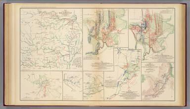
Map of the fall campaigns of the Army of Missouri, Maj. Gen. Sterling Price, commanding in Sept., Oct., Nov. 1864. Capt. T.J. Mackey, Chf. Engr. (with) No. 2. Map of the battle of Chickamauga showing the positions of the Confederate and Federal armies on the 19th September, 1863 ... by Walter J. Morris ... (with) No. 3. Map of the battle of Chickamauga ... 19th September 1863 ... by Walter J. Morris ... (with Marietta Region, Georgia). Accompanying letter of Maj. Gen. J.M. Scholfield ... (with Peach Tree Creek Region, Georgia) Marked "Thomas" by Gen. Sherman. (with) Mine Run, Va. and vicinity, 1863. (with) No. 1. Map showing the positions of the Confederate Army and that of the Federal Army at midnight on the 18th of September, 1863, the night previous to the general engagements of the 19th and 20th Sept., or the Battle of Chickamauga ... by Walter J. Morris ... (with) Map of the engagement at Wauhatchie, Tenn., October 28th and 29th, 1863 and of the operations of the 11th and 12th Army Corps preliminary thereto. Accompanying report of Maj. Gen. Joseph Hooker. Julius Bien & Co., Lith., N.Y. (1891-1895)
List No
1780.047
Note
Col. map with 7 ancillary maps. Relief in some ancillary maps shown by hachures or form lines.
Author
United States. War Department
Full Title
Engineer Bureau, War Department. Section of map of the states of Kansas and Texas and Indian Territory, with parts of the territories of Colorado and New Mexico. From the most recent official surveys and explorations and other authentic information. 1867. Julius Bien & Co., Lith., N.Y. (1891-1895)
List No
1780.119
Note
Col. map. Relief shown by hachures. Shows settlements, Indian reservations, roads, railroads, forts, etc. Includes table of locations with coordinates and list of authorities.
Author
U.S. War Department, Topographical Engineers
Full Title
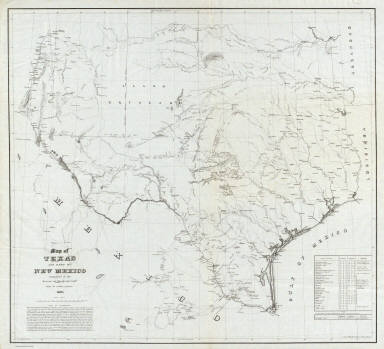
Map of Texas and part of New Mexico compiled in the Bureau of Topgraphl. Eng'rs. chiefly for military purposes, 1857 ... Lith. of Ritchie & Dunnovant. Printed at H.F. Walling's Map Establishment, 90 Fulton St., New York.
List No
5141.000
Note
Probably the best and most detailed military map of Texas issued before the Civil War - rivers, roads, explorer's routes, water holes, forts and towns are shown. Includes "List of authorities." The Warren map of 1857 (see our #4013) incorporates much of this information, with even more information from this map appearing on the Warren map of 1858 (see our #2750). A later version of this map appeared in the Atlas To Accompany The Official Records of the Union and Confederate Armies (see our #1780) as plate 54. Martin and Martin incorrectly state that the map was not published until it appeared in the "Atlas to Accompany..." This is the only government map published by H.F. Walling that we know of. This copy came from a group of about ten copies found with the J.D. Graham papers. Without color. Scarce. Relief shown by hachures.
Author
Dorn, Frank
Full Title
A Map and History of the Military Reservation of Fort Sill, Oklahoma.
List No
9761.000
1-4 of 4
|