|
REFINE
Browse All : Military of New Mexico and Texas
1-2 of 2
Author
United States. War Department
Full Title
Map of Texas and part of New Mexico, compiled in the Bureau of Topographl. Engrs. chiefly for military purposes. Information on this map furnished by Wm. E. Young, C.E. and compiled under the direction of Maj. D.C. Houston, Chief Engr., Dept. of the Gulf. Accompanying letter of Gen. N.P. Banks ... (with) Plan of the battle-field at New Creek, W. Va., August 4th, 1864. (with) Plan of the battle-field at Pleasant Mills near Cumberland, Md., August 1st, 1864. Made by F.M. Knight. ... Julius Bien & Co., Lith., N.Y. (1891-1895)
List No
1780.054
Note
Col. map with 2 ancillary maps. Relief shown by hachures. Includes table of stations and notes on selected rivers.
Author
U.S. War Department, Topographical Engineers
Full Title
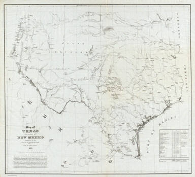
Map of Texas and part of New Mexico compiled in the Bureau of Topgraphl. Eng'rs. chiefly for military purposes, 1857 ... Lith. of Ritchie & Dunnovant. Printed at H.F. Walling's Map Establishment, 90 Fulton St., New York.
List No
5141.000
Note
Probably the best and most detailed military map of Texas issued before the Civil War - rivers, roads, explorer's routes, water holes, forts and towns are shown. Includes "List of authorities." The Warren map of 1857 (see our #4013) incorporates much of this information, with even more information from this map appearing on the Warren map of 1858 (see our #2750). A later version of this map appeared in the Atlas To Accompany The Official Records of the Union and Confederate Armies (see our #1780) as plate 54. Martin and Martin incorrectly state that the map was not published until it appeared in the "Atlas to Accompany..." This is the only government map published by H.F. Walling that we know of. This copy came from a group of about ten copies found with the J.D. Graham papers. Without color. Scarce. Relief shown by hachures.
1-2 of 2
|