|
REFINE
Browse All : Military of Japan
1-32 of 32
Author
News Map of the Week, Inc.
Full Title
World News of the Week : Monday, May 11, 1942. Covering period May 1 to 7. Volume 4, No. 36. Published and copyrighted (weekly), 1942, by News Map of the Week, Inc., 1512 Orleans Street, Chicago, Illinois. Published in two sections : Section one. Lithographed in U. S. A.
List No
14098.000
Note
Lithographed world map, in color. Shows political boundaries and military events of World War II, from May 1 to 7, 1942. Relief illustrated with hachures. Descriptive text throughout, e.g.: Where Japanese warship concentration is reported. Map indexed according to historical notes beneath map. Features photographs, illustrations, and international time zones. With eight inset maps: The Japanese Empire, Manchukuo to Corregidor : Japan, 1930 -- Japan, 1932 -- Japan, before Pearl Harbor -- Japan, Dec. 7 - Jan. 7, 1942 -- Japan, Jan. 7 - Feb. 7, 1942 -- Japan, Feb. 7 - Mar. 7, 1942 -- Japan, Mar. 7 - Apr. 7, 1942 -- Japan, April 7 to present. Map is 56 x 115 cm, on sheet 89 x 120 cm, folded to 31 x 23 cm.
Author
Sundberg, Edwin L.
Full Title
Armed Truce in the Far East. News Map by staff artist Sundberg. Sunday News, September 25, 1938.
List No
13664.000
Author
News Map of the Week, Inc.
Full Title
World News of the Week : Monday, Dec. 15, 1941. Covering period Dec. 5 to Dec. 11. Volume 4, No. 15. Published and copyrighted (weekly), 1941, by News Map of the Week, Inc., 1512 Orleans Street, Chicago, Illinois. Published in two sections : Section one. Lithographed in U. S. A.
List No
14082.000
Note
Lithographed world map, in color. Shows political boundaries and military events of World War II, from December 5 to 11, 1941. Relief illustrated with hachures. Includes a legend indicating national sovereignty, including colonies. Descriptive text throughout, e.g.: Route over which Mexican forces will travel to Lower California. Map indexed according to historical notes beneath map. Features photographs, illustrations, and international time zones. With three inset maps: The Philippine Islands -- Japanese target -- Hitler's Best bets for winter. Also, with diagram: Aliens in America. Map is 56 x 115 cm, on sheet 89 x 120 cm, folded to 31 x 23 cm.
Author
News Map of the Week, Inc.
Full Title
World News of the Week : Monday, Jan. 26, 1942. Covering period Jan. 16 to Jan. 22. Volume 4, No. 21. Published and copyrighted (weekly), 1942, by News Map of the Week, Inc., 1512 Orleans Street, Chicago, Illinois. Published in two sections : Section one. Lithographed in U. S. A.
List No
14086.000
Note
Lithographed world map, in color. Shows political boundaries and military events of World War II, from January 16 to 22, 1942. Relief illustrated with hachures. Descriptive text throughout, e.g.: Dutch Islands being guarded by U. S. Air Force. Map indexed according to historical notes beneath map. Features photographs, illustrations, and international time zones. With two inset maps: Malay States -- When the Allies attack Japan. Also, with diagram: Average hourly wage rates in manufacturing industry. Map is 56 x 115 cm, on sheet 89 x 120 cm, folded to 31 x 23 cm.
Author
Burke, Howard
Full Title
Los Angeles Examiner. Tuesday, September 29, 1942 : Tokyo's Next Bombing May Come From Vladivostok. Howard Burke.
List No
13178.000
Note
Color map from the Los Angeles Examiner Pictorial Review section, Sept. 29, 1942. Illustrated by Howard Burke. With 2 inset maps: Manchukuo and Soviet Russia. Shows battle fields, naval and air force areas, roads and railroads. Includes informative text and overview of the geopolitical situation of the area.
Author
Burke, Howard
Full Title
Kiska Seen as Key Base to Attack Paramushiro, Japan. Pictorial review : Los Angeles Examiner, August 10, 1943. Howard Burke.
List No
13181.000
Note
Color pictorial map from the Los Angeles Examiner Pictorial Review section, by Los Angeles Examiner artist Howard Burke. Published by Los Angeles Examiner. Los Angeles. 08-10- 1943. Showing a bird's eye view of Kiska Island. Depicts fighter jets with naval bases. Text at lower right provides an overview of the strategic location of the island.
Author
[Burke, Howard, Los Angeles Examiner]
Full Title
Japan and Russia Will Divide China. Signs Increase That Northern Area and Lower Yangtze Basin Will be Carved Into Puppet States by Stalin and Mikado, Leaving South Largely at Mercy of Both. March of events : Screen and drama. Milwaukee News Sentinel : Sunday, April 28, 1940. Map copyrighted 1940 by Los Angeles Examiner.
List No
11885.000
Note
Pictorial map from the Milwaukee News-Sentinel March of Events section. Illustrated by Los Angeles Examiner artist Howard Burke covering the area China, Japan, Southern Russia and the northern part of French Indochina and Siam, showing how the "Aggressors Divide China." Map showing naval and air bases, areas under Japanese occupation are shown in red. Also showing cities, rivers, roads, mountains, agricultural products and raw materials. Includes text, text labels and and dated events providing an effective overview of the geopolitical situation.
Author
Anonymous
Full Title
Shinkoku Taihei Take Mori Mata Akira.
List No
11528.000
Note
Wood block print, pictorial map of the coast defense of Tokyo Bay. Kawaraban Broadside Map depicting arrival of Perry's "Black Ships," describing the arrival of the American Commodore Matthew Perry to Edo Bay (Tokyo Bay) in 1854 (Kaei 6), after his earlier brief visit in 1853. The defensive ships identified by the warlord in charge and his armorial crest are around the bay to intimidate the invaders. Includes notes describing the troops and list of names of Samurais in charge of defense of Tokyo Bay. Includes an illustration in the upper right depicting an American soldier. Perry's ships were the first major western intrusion into Japan. “Perry, on behalf of the U.S. government, forced Japan to enter into trade with the United States and demanded a treaty permitting trade and the opening of Japanese ports to U.S. merchant ships. This was the era when all Western powers were seeking to open new markets for their manufactured goods abroad, as well as new countries to supply raw materials for industry. It was clear that Commodore Perry could impose his demands by force. The Japanese had no navy with which to defend themselves, and thus they had to agree to the demands… Upon seeing Perry's fleet sailing into their harbor, the Japanese called them the "black ships of evil mien (appearance)." Many leaders wanted the foreigners expelled from the country, but in 1854 a treaty was signed between the United States and Japan which allowed trade at two ports. In 1858 another treaty was signed which opened more ports and designated cities in which foreigners could reside. The trade brought much foreign currency into Japan disrupting the Japanese monetary system. Because the ruling shogun seemed unable to do anything about the problems brought by the foreign trade, some samurai leaders began to demand a change in leadership. The weakness of the Tokugawa shogunate before the Western demand for trade, and the disruption this trade brought, eventually led to the downfall of the Shogunate and the creation of a new centralized government with the emperor as its symbolic head.” Source: Asia for Educators, Columbia University.
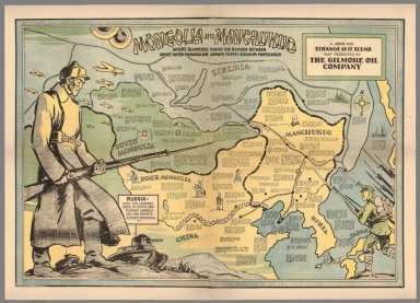
Author
Hix, John
Full Title
Mongolia and Manchukuo : Where bloodshed marks the border between Soviet outer Maongolia and Japan's puppet Kingdom Manchukuo. A John Hix strange as it seems map presented by the Gilmore Oil Company.
List No
8354.000
Note
Color pictorial map, mounted on linen, with numerous statistical and dated explanatory text. Shows a large Russian soldier, on the left dominating the map, and small illustration of a Japanese soldier on the lower right. Shows boundaries, railroads, native people in each region, Great wall of China, Russia vessels and war planes, battle ships, and compass rose oriented to upper left margin. Relief shown pictorially. Date estimated.
Author
Burke, Howard
Full Title
Two ways to reach Japan - One may take a decade. Los Angels Examiner ... Monday January 11, 1943. 22 Section 1. Howard Burke. (inset) Kusaie.
List No
8064.000
Note
Color pictorial map, mounted on Japanese paper. With inset at lower left corner. Showing East Asia with Military Bases and Japanese-Occupied Territory note. Text box at lower right describes Japan as a porcupine with "long and dangerous quills spreading across the Pacific. ... Every day it grows stronger. The barbs of invasion that threaten Australia, the Solomons, Alaska, and Pacific Coast are toughening." The inset map of Kusaie (now Kosrae) notes "Reliable Reports say Japs have made powerful base of this island." Relief shown pictorially. Includes informative text labels.
Author
[Los Angeles Times, Owens, Charles H.]
Full Title
What are the possibilities of attacking the Islands of Japan. Map by Charles Owens, Times Staff Artist. Los Angeles Times Monday morning, May 4, 1942.
List No
11022.000
Note
Color map. Shows lines of air attack to Japan, distances, bases, major cities, population, rail roads, etc. Relief shown pictorially. Includes historical notes and text: "This map, in line and legend, pictures possibilities of invasion by way of China and Korea, by way of Russia and briefly, from the north by way of Alaska ..."
Author
[Los Angeles Times, Owens, Charles H.]
Full Title
Japan's last citadels feel weight of American power. Map by Charles H. Owens. Times staff Artist. Los Angeles times. Monday, Feb. 19, 1945 - Part 3.
List No
11031.000
Note
Color map, with views of air attack and war planes at upper panel. Shows lines of attack by air and sea, major cities, roads, army bases, distances, etc. Relief shown pictorially. Includes historical notes and text.
Author
Los Angeles Times
Full Title
U.S. sea and air power trained on Japan home land. Los Angeles times. Monday, June 26, 1944 - Part 3. (inset map).
List No
11033.000
Note
Color map. Shows Japan's major cities, roads, railroads, industrial areas, etc. Relief shown pictorially. Includes historical notes and text. Inset map: "The sea-air battle near the Philippines in water that wash Japan's southeastern shores brought the war home to the enemy from that quarter ..."
Author
[Los Angeles Times, Rand McNally & Company]
Full Title
Jam packed Nipponese Islands offer rare target for United Nations' bombing squadrons. Japan. Copyright by Rand McNally & company, Chicago. Los Angeles times. Saturday Morning. April 25, 1942 - (Part I.)
List No
11037.000
Note
Color map of Japan, with 3 insets. Shows major cities, roads, etc. Relief shown by hachures. Prime meridian is Greenwich. Includes text.
Author
[Harrison, Richard Edes, St. Louis Post dispatch]
Full Title
China : Orient's red stronghold. Japan : United States' Bulwark against Red Expansion. Richard Edes Harrison. Special Atlas Section - St. Louis Post Dispatch. Sunday, September 12, 1954.
List No
11507.002
Note
2 color maps on 1 page, with descriptive text. Shows political and administrative divisions, place names and distances. Relief shown by shadings. Note: "This map originally appeared in Fortune magazine and is reprinted by special permission. Copyright by TIME Inc."
Author
[Manning, F. E., Kaltenborn, H. V., Pure Oil Company.]
Full Title
Southeast Asia (Scale: ca. 1:5,500,000). Japan (Scale: ca. 2,450,000). Northeast China and Japan (Scale: ca. 1:5,300,000). Philippines (Scale: ca. 5,500,000). (inset diagram). All maps designed and executed by F.E. Manning. (cover title) Pacific War maps. Edited by H v Kaltenborn ...
List No
11572.003
Note
4 color maps on 1 sheet, folded. With inset diagram. Showing naval and air bases, roads, railroads rivers, mountains and distances. Relief shown by shadings; depth shown by bathymetric tints.
Author
Burke, Howard
Full Title
San Francisco Examiner : Okinawa Gateway to Japanese Homeland. Howard Burke.
List No
13177.000
Note
Two color maps, published on newspaper sheet by San Francisco Examiner, 04,09,1945. Illustrated by Howard Burke & Kelly. Depicts fighter jets with naval forces in the area of the Kerama Islands and Naha. The importance of the battle for Okinawa is laid out in the smaller map at upper left and in the accompanying text: "The invasion of this important base caused a Japanese cabinet to fall, and when Okinawa is in full operation by the Allies it may cause the fall of Japan."
Author
Asia Weekly
Full Title
大東亜戦争 = Dai Tō-A Sensō = War map of the Greater East Asia.
List No
13509.001
Author
United States. Army Service Forces. Army Information Branch.
Full Title
Newsmap for the Armed Forces : V-E Day + 15 weeks - 192nd .Week of U.S. participation in the War. The knockout blows fall. Prepared and distributed by Army Information Branch, Army Service Forces. Navy Distribution and Educational Services Section, Bupers, Navy Dept., Washington, D.C. Monday, 20 August, 1945, week of 7 August to 14 August - Volume IV No. 18F. (on verso) Advance Base Sectional Docks.
List No
13584.001
Author
United States. Army Service Forces. Army Information Branch.
Full Title
Newsmap for the Armed Forces : V-E Day + 15 weeks - 192nd Week of U.S. participation in the War. The knockout blows fall. Prepared and distributed by Army Information Branch, Army Service Forces. Navy Distribution and Educational Services Section, Bupers, Navy Dept., Washington, D.C. Monday, 20 August, 1945, week of 7 August to 14 August - Volume IV No. 18F. (on verso) Advance Base Sectional Docks.
List No
13584.002
Author
[Československá akademie věd., Klíma, Jan]
Full Title
Rusko-Japonská válka v I. 1904-1905 = I část - II část - Balkánské války. Československý vojenský atlas.
List No
13684.224
Note
3 Timeline maps, with 9 inset maps, text and legends, on 2 sheets. Showing parts I-II map of the Russo-Japanes war. And 2 maps of Balkan region in 1912-1913.
Author
[Československá akademie věd., Klíma, Jan]
Full Title
Operace v oblasti Tichého Oceánu v I. 1944-1945. Československý vojenský atlas.
List No
13684.284
Note
Timeline folded map of the Pacific War, with 2 insets, text, table and legend. Covered a large portion of the Pacific Ocean, East Asia, Southeast Asia and Northern Australia.
Author
[Československá akademie věd., Klíma, Jan]
Full Title
Porážka Japonských vojsk armádou (9.8 - 2.9. 1945). Československý vojenský atlas.
List No
13684.285
Note
Timeline map of the Pacific war, with inset: Russian operation in Shumshu Island. Includes text, table and legend. Showing defeat of Japanese troops by the army Aug. 8- Sept. 2, 1945
Author
News Map of the Week, Inc.
Full Title
World News of the Week : Monday, Mar. 9, 1942. Covering period Feb. 27 to Mar. 5. Volume 4, No. 27. Published and copyrighted (weekly), 1942, by News Map of the Week, Inc., 1512 Orleans Street, Chicago, Illinois. Published in two sections : Section one. Lithographed in U. S. A.
List No
14089.000
Note
Lithographed world map, in color. Shows political boundaries and military events of World War II, from February 27 to March 5, 1942. Relief illustrated with hachures. Descriptive text throughout, e.g.: Where U. S. Destroyer was sunk by sub. Map indexed according to historical notes beneath map. Features photographs, illustrations, and international time zones. With two inset maps: Island of Java -- Twelve strategic steps in the Japanese drive. Map is 56 x 115 cm, on sheet 89 x 120 cm, folded to 31 x 23 cm.
Author
News Map of the Week, Inc.
Full Title
World News of the Week : Monday, Apr. 6, 1942. Covering period Mar. 27 to Apr. 2. Volume 4, No. 31. Published and copyrighted (weekly), 1942, by News Map of the Week, Inc., 1512 Orleans Street, Chicago, Illinois. Published in two sections : Section one. Lithographed in U. S. A.
List No
14093.000
Note
Lithographed world map, in color. Shows political boundaries and military events of World War II, from March 27 to April 2, 1942. Relief illustrated with hachures. Descriptive text throughout, e.g.: Scene of Arctic Sea Battle. Map indexed according to historical notes beneath map. Features photographs, illustrations, and international time zones. With two inset maps: (North to the realm of Japan?) -- (Thailand). Also, with three diagrams: Principal regions of India (census of 1931) -- (Submarine plan) -- (Submarine sights ship). Map is 56 x 115 cm, on sheet 89 x 120 cm, folded to 31 x 23 cm.
Author
News Map of the Week, Inc.
Full Title
World News of the Week : Monday, Apr. 27, 1942. Covering period Apr. 17 to 23. Volume 4, No. 34. Published and copyrighted (weekly), 1942, by News Map of the Week, Inc., 1512 Orleans Street, Chicago, Illinois. Published in two sections : Section one. Lithographed in U. S. A.
List No
14096.000
Note
Lithographed world map, in color. Shows political boundaries and military events of World War II, from April 17 to 23, 1942. Relief illustrated with hachures. Includes a legend indicating locations of bombings, as well as American troops stationed outside the continental United States. Descriptive text throughout, e.g.: Russians launch drives here. Map indexed according to historical notes beneath map. Features photographs, illustrations, and international time zones. With inset map: Stronghold of the enemy. Also, with two diagrams: Farm workers in the United States -- Airplane production in U. S. Map is 56 x 115 cm, on sheet 89 x 120 cm, folded to 31 x 23 cm.
Author
News Map of the Week, Inc.
Full Title
World News of the Week : Monday, Jan. 11, 1943. Covering period Jan. 1 to Jan. 7. Volume 5, No. 19. Published and copyrighted (weekly), 1943, by News Map of the Week, Inc., 1512 Orleans Street, Chicago, Illinois. Published in two sections : Section one. Lithographed in U. S. A.
List No
14118.000
Note
Lithographed world map, in color. Shows political boundaries and military events of World War II, from January 1 to 7, 1943. Relief illustrated with hachures. Descriptive text throughout, e.g.: Towns in Caucasus recaptured by Russians. Map indexed according to historical notes beneath map. Features photographs, illustrations, and international time zones. With four inset maps: Roads to Rostov -- Japanese Pacific Strongholds -- Pattern of Allied offensives -- (Ukraine). Also, with diagram: School background of the draftees. Map is 56 x 115 cm, on sheet 89 x 120 cm, folded to 31 x 23 cm.
Author
Harrison, Richard Edes
Full Title
Japan To Alaska. (drawn by) Richard Edes Harrison 1943. Copyright 1943. Time Inc. (to accompany) Look At The World: The Fortune Atlas For world Strategy. By Richard Edes Harrison. Text by Editor of Fortune. New York: Alfred A. Knopf 1944. (on verso) Copyright 1944 by Time Incorporated.
List No
1970.028
Note
Full color shaded relief map. Includes text, and location map. Atlas contains 66, (2) page text, index, statistics, color, and black and white maps (some folded) and plans. Covers are teal blue with the title "Look at the world: the Fortune Atlas For world Strategy. By Richard Edes Harrison. Text by Editor of Fortune. New York: Alfred A. Knopf." in center.
Author
Harrison, Richard Edes
Full Title
Japan From The Solomons. (drawn by) Richard Edes Harrison 1943. Copyright 1943. Time Inc. (to accompany) Look At The World: The Fortune Atlas For world Strategy. By Richard Edes Harrison. Text by Editor of Fortune. New York: Alfred A. Knopf 1944. (on verso) Copyright 1944 by Time Incorporated.
List No
1970.029
Note
Full color shaded relief map. Includes relief map of Solomon Islands, New Guinea Caroline Islands ... , text, and location map. Atlas contains 66, (2) page text, index, statistics, color, and black and white maps (some folded) and plans. Covers are teal blue with the title "Look at the world: the Fortune Atlas For world Strategy. By Richard Edes Harrison. Text by Editor of Fortune. New York: Alfred A. Knopf." in center.
Author
Harrison, Richard Edes
Full Title
Japan From China. (drawn by) Richard Edes Harrison 1943. Copyright 1943. Time Inc. (to accompany) Look At The World: The Fortune Atlas For world Strategy. By Richard Edes Harrison. Text by Editor of Fortune. New York: Alfred A. Knopf 1944. (on verso) Copyright 1944 by Time Incorporated.
List No
1970.030
Note
Full color shaded relief map. Includes location map. Atlas contains 66, (2) page text, index, statistics, color, and black and white maps (some folded) and plans. Covers are teal blue with the title "Look at the world: the Fortune Atlas For world Strategy. By Richard Edes Harrison. Text by Editor of Fortune. New York: Alfred A. Knopf." in center.
Author
Harrison, Richard Edes
Full Title
Japan From Siberia. (drawn by) Richard Edes Harrison 1943. (to accompany) Look At The World: The Fortune Atlas For world Strategy. By Richard Edes Harrison. Text by Editor of Fortune. New York: Alfred A. Knopf 1944. (on verso) Copyright 1944 by Time Incorporated.
List No
1970.031
Note
Full color shaded relief map. Includes relief map of Siberia, Manchuria ... and location map. Atlas contains 66, (2) page text, index, statistics, color, and black and white maps (some folded) and plans. Covers are teal blue with the title "Look at the world: the Fortune Atlas For world Strategy. By Richard Edes Harrison. Text by Editor of Fortune. New York: Alfred A. Knopf." in center.
Author
[Army Information Branch, Navy Educational Services Section]
Full Title
Major Bases Proposed for Postwar U.S. Navy. Japan. Newsmap for the Armed Forces. Monday, September 17, 1945. Volume IV No. 22F. Prepared and Distributed by the Army Information Branch, Army Service Forces, Navy Distribution by Educational Services Section, Bupers, Navy Dept., Washington D.C. U.S. Government Printing Office: 1945 - 854909. Comparison Chart of Non-Commissioned Grades and Ratings of the Armed Forces.
List No
6768.001
1-32 of 32
|