|
REFINE
Browse All : Military of China
1-37 of 37
Author
News Map of the Week, Inc.
Full Title
World News of the Week : Monday, May 15, 1944. Covering period May 5 to May 11. Volume 6, No. 37. Published and copyrighted (weekly), 1944, by News Map of the Week, Inc., 1512 Orleans Street, Chicago, Illinois. Published in two sections : Section one. Lithographed in U. S. A.
List No
14172.000
Note
Lithographed world map, in color. Shows political boundaries and military events of World War II, from May 5 to 11, 1944. Relief illustrated with hachures. Includes a key indicating the alignment of warring nations (United, Axis, and neutral). Descriptive text throughout, e.g.: Nazis note Anzio activities; flood Pontine Marshes. Map indexed according to historical notes beneath map. Features photographs, illustrations, and international time zones. With four inset maps: (Where Allies concentrate bombers in Europe) -- (Pontine Marshes) -- (China) -- Great Britain and Land-Lease in reverse. Map is 56 x 115 cm, on sheet 89 x 120 cm, folded to 31 x 23 cm.
Author
Fukunaga, Sokyo. 福永祖恭
Full Title
最詳戦局地図. [Saisho senkyoku chizu]. [Most Detailed Map of the War Situation].
List No
15075.000
Note
Showa 18 [ 1943]
Author
China History Museum 中国历史博物馆
Full Title
[First Sino-Japanese War. 1894 - 1895.]. 中日战争图. 1894 - 1895年. [Zhong Ri zhan zheng tu. 1894 - 1895 nian].
List No
15078.002
Author
China History Museum 中国历史博物馆
Full Title
[Map of Peasant Rebellion during Late Qin Period]. 秦末农民战争图. [Qin mo nong min zhan zheng tu].
List No
15079.002
China Cartographic Publishing House 地图出版... [Situation Map of Kingdoms of the Spring... 1981 15080.002 Related Author
China Cartographic Publishing House 地图出版社
Full Title
[Situation Map of Kingdoms of the Spring and Autumn Period] 春秋列国形势图. [Chun qiu lie guo xing shi tu].
List No
15080.002
Author
China History Museum 中国历史博物馆
Full Title
[Situation Map of the Yellow Turban Rebellion]. 黄巾起义形势图. [Huang jin qi yi xing shi tu].
List No
15081.002
Author
China History Museum 中国历史博物馆
Full Title
[Situation Map of National Protection Movement]. 护国运动形势图. [Hu guo yun dong xing shi tu].
List No
15082.002
Author
China History Museum 中国历史博物馆
Full Title
[Situation Map of National Protection Movement]. 中国原始社会氏族公社遗址分布图. [Zhongguo yuan shi she hui shi zu gong she yi zhi fen bu tu].
List No
15084.002
Author
Anonymous
Full Title
Haikou Quantu 海口全圖 [Complete Map of Sea Ports]. Wanguo tu & Wukou Yanhai Shuilu Quantu 萬國圖 & 五口沿海水路全圖 [Map of 10,000 Countries & Complete Map of the Five Coastal Estuaries].
List No
15039.003
Author
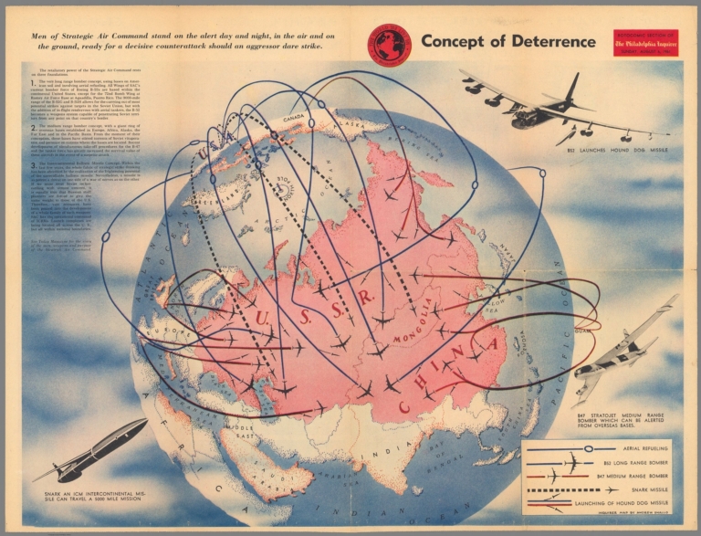
Shallo, Andrew, 1922-1979
Full Title
Concept of Deterrence. Rotocomic section of The Philadelphia Inquirer, Sunday, Augus 6, 1961. Inquirer map by Andrew Shallo.
List No
13583.001
Author
Burke, Howard
Full Title
Pictorial Review : San Francisco Examiner Sunday, Oct. 20, 1940. Rich Dutch Colonies at Stake. Will Japan Try to Take Them? Will the United States Defend Them?. Howard Burke.
List No
13175.000
Note
Color pictorial map, front page of the San Francisco Examiner Pictorial Review section. Illustrated by Howard Burke, focuses on eastern hemisphere, with bird's eye view inset map of Singapore and a vignette illustration at the lower left corner of elephants and temple. Japan and Japanese occupied areas are shown in red. Includes informative text and small pictographs provide an effective overview of the geopolitical situation. Includes legend. Relief shown pictorially.
Author
[Burke, Howard, Los Angeles Examiner]
Full Title
Japan and Russia Will Divide China. Signs Increase That Northern Area and Lower Yangtze Basin Will be Carved Into Puppet States by Stalin and Mikado, Leaving South Largely at Mercy of Both. March of events : Screen and drama. Milwaukee News Sentinel : Sunday, April 28, 1940. Map copyrighted 1940 by Los Angeles Examiner.
List No
11885.000
Note
Pictorial map from the Milwaukee News-Sentinel March of Events section. Illustrated by Los Angeles Examiner artist Howard Burke covering the area China, Japan, Southern Russia and the northern part of French Indochina and Siam, showing how the "Aggressors Divide China." Map showing naval and air bases, areas under Japanese occupation are shown in red. Also showing cities, rivers, roads, mountains, agricultural products and raw materials. Includes text, text labels and and dated events providing an effective overview of the geopolitical situation.
Author
Chapin, Jr., R.M.
Full Title
Choking Chungking. TIME map by R.M. Chapin, Jr. For report documenting above map see Time, Decmeber 11, 1944 issue.
List No
11771.000
Note
Color map. "Enlargement of original map drawn for TIME The weekly magazine.". R.M. Chapin Jr. was a prominent Cold War cartographer who worked for Time Magazine. Relief shown by shading.
Author
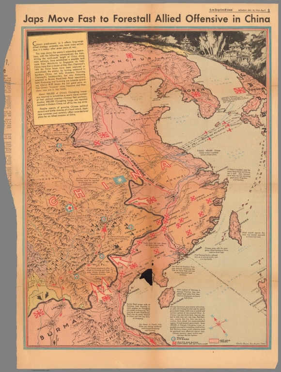
[Los Angeles Times, Owens, Charles H.]
Full Title
Japs move fast to forestall allied offensive in China. Charles Owens, Los Angeles Times. Los Angeles Times, Monday, Dec. 18, 1944 - Part 3.
List No
11025.000
Note
Color map, with detailed view air strikes at upper panel. Covers China, Korea and part of Japan and Burma. Shows lines of air attack, major cities, allied air bases, distances, etc. Relief shown pictorially. Includes historical notes and text.
Author
[Harrison, Richard Edes, St. Louis Post dispatch]
Full Title
China : Orient's red stronghold. Japan : United States' Bulwark against Red Expansion. Richard Edes Harrison. Special Atlas Section - St. Louis Post Dispatch. Sunday, September 12, 1954.
List No
11507.002
Note
2 color maps on 1 page, with descriptive text. Shows political and administrative divisions, place names and distances. Relief shown by shadings. Note: "This map originally appeared in Fortune magazine and is reprinted by special permission. Copyright by TIME Inc."
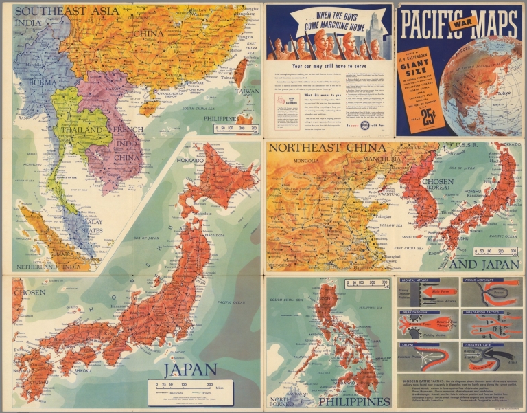
Manning, F. E.; Kaltenborn, H. V.; Pure ... Southeast Asia. Japan. Northeast China. ... 1944 11572.003 Related Author
[Manning, F. E., Kaltenborn, H. V., Pure Oil Company.]
Full Title
Southeast Asia (Scale: ca. 1:5,500,000). Japan (Scale: ca. 2,450,000). Northeast China and Japan (Scale: ca. 1:5,300,000). Philippines (Scale: ca. 5,500,000). (inset diagram). All maps designed and executed by F.E. Manning. (cover title) Pacific War maps. Edited by H v Kaltenborn ...
List No
11572.003
Note
4 color maps on 1 sheet, folded. With inset diagram. Showing naval and air bases, roads, railroads rivers, mountains and distances. Relief shown by shadings; depth shown by bathymetric tints.
Author
Sundberg, Edwin L.
Full Title
The Chinese Puzzle. January 14, 1945.
List No
12275.000
Author
Burke, Howard
Full Title
San Francisco Examiner : China drive may open invasion path. Howard Burke.
List No
13176.000
Note
Color map, published on newspaper sheet by San Francisco Examiner, May 28, 1945. Illustrated by Howard Burke. Covers China, Korea, Philippine Islands and Taiwan. Includes informative text and overview of the geopolitical situation.
Author
Fuchida, Tadayoshi
Full Title
最新世界大地図 = Saishin sekai daichizu. Shina zendo narabi fukin daichizu. Oshū gensei daichizu = Latest World Map. (on verso) Map of the Whole of China. Current Map of Europe. Fuchida Tadayoshi. Kingu, Volume 15, no.1. Tokyo, Dainihon Yūbenkai Kōdansha, Showa 14 (1940).
List No
13462.003
Note
2 color maps on 1 sheet. Map of the Whole of China, at scale of 1:5,600,000 and Current Map of Europe, at scale of 1:12,000,000. yoshi
United States. Army Service Forces. Army... Newsmap for the Armed Forces : The knock... 1945 13584.001 Related Author
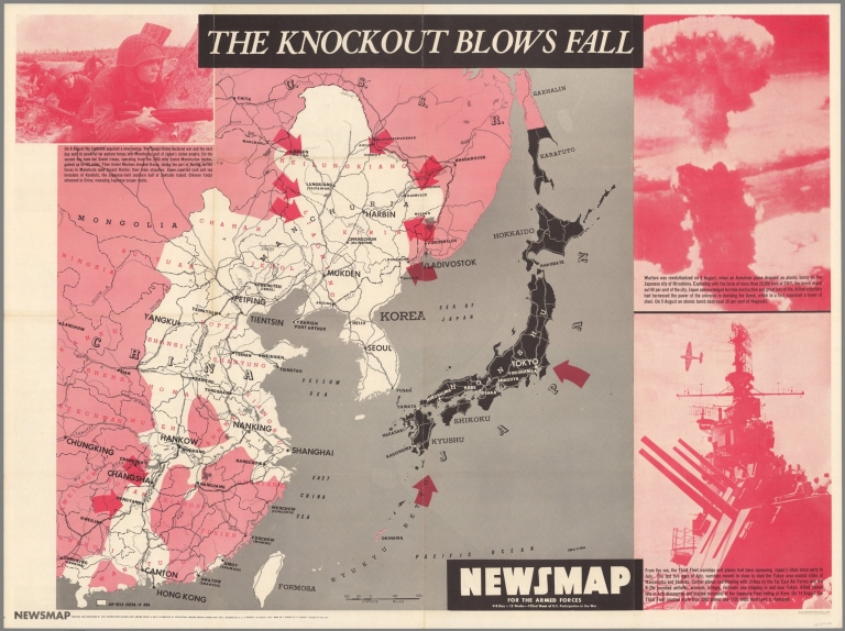
United States. Army Service Forces. Army Information Branch.
Full Title
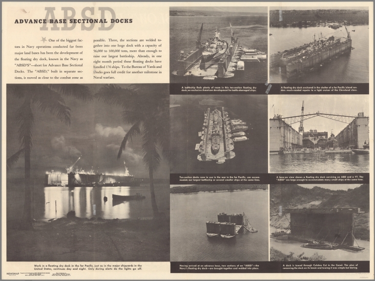
Newsmap for the Armed Forces : V-E Day + 15 weeks - 192nd .Week of U.S. participation in the War. The knockout blows fall. Prepared and distributed by Army Information Branch, Army Service Forces. Navy Distribution and Educational Services Section, Bupers, Navy Dept., Washington, D.C. Monday, 20 August, 1945, week of 7 August to 14 August - Volume IV No. 18F. (on verso) Advance Base Sectional Docks.
List No
13584.001
United States. Army Service Forces. Army... Newsmap for the Armed Forces : The knock... 1945 13584.002 Related Author
United States. Army Service Forces. Army Information Branch.
Full Title
Newsmap for the Armed Forces : V-E Day + 15 weeks - 192nd Week of U.S. participation in the War. The knockout blows fall. Prepared and distributed by Army Information Branch, Army Service Forces. Navy Distribution and Educational Services Section, Bupers, Navy Dept., Washington, D.C. Monday, 20 August, 1945, week of 7 August to 14 August - Volume IV No. 18F. (on verso) Advance Base Sectional Docks.
List No
13584.002
Československá akademie věd.; Klíma,... Valky v Období vzniku a počátečního rozv... 1965 13684.181 Related Author
[Československá akademie věd., Klíma, Jan]
Full Title
Valky v Období vzniku a počátečního rozvoje starovékých Otrokářských státú. Československý vojenský atlas̊.
List No
13684.181
Note
4 maps, with 4 insets on double sheet. Including: map A, showing the origin of the ancient states. Map B, showing development of the War of the ancient Slave States. Map C, showing War of ancient India and China. Map D. Middle East war early 9th and mid-6th centuries. Maps include legend and text.
Československá akademie věd.; Klíma,... Války v Asii v 15. -17. stol. -Války v E... 1965 13684.205 Related Author
[Československá akademie věd., Klíma, Jan]
Full Title
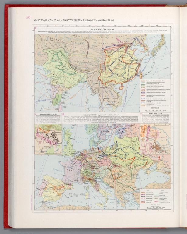
Války v Asii v 15. -17. stol. - Války v Evrope v 2 poloviné 17 a počátkem 18. stol.Československý vojenský atlas.
List No
13684.205
Note
2 Timeline maps, with 2 inset map, text and legends on 1 sheets. Showing the war in India and China. And War in Europe.
Československá akademie věd.; Klíma,... První války Období Imperialismu (1898-19... 1965 13684.223 Related Author
[Československá akademie věd., Klíma, Jan]
Full Title
První války Období Imperialismu (1898-1902). Československý vojenský atlas.
List No
13684.223
Note
3 Timeline maps, with 3 inset maps, text and legends, on 1 sheet. Showing Spanish-American war in 1898 - Philippines-American war in 1898 - Division of China by the imperialist powers of the early 20th century - Anglo-Boer War 1899-1902.
Československá akademie věd.; Klíma,... Občanské revoluční války v Číné (1924-19... 1965 13684.244 Related Author
[Československá akademie věd., Klíma, Jan]
Full Title
Občanské revoluční války v Číné (1924-1936). Československý vojenský atlas.
List No
13684.244
Note
2 Timeline maps, with legend and text on 1 sheet. Showing Chinese Civil War, 1924-27 and 1927-36.
Československá akademie věd.; Klíma,... Národné osvobozenecká válka Činského lid... 1965 13684.245 Related Author
[Československá akademie věd., Klíma, Jan]
Full Title
Národné osvobozenecká válka Činského lidu proti Japonským Imperialistúm (1937-1945). Československý vojenský atlas.
List No
13684.245
Note
Timeline map, with legend and text. Showing national liberation Sino-Japanese War, (1937–45).
Československá akademie věd.; Klíma,... Operace v oblasti Tichého Oceánu v I. 19... 1965 13684.284 Related Author
[Československá akademie věd., Klíma, Jan]
Full Title
Operace v oblasti Tichého Oceánu v I. 1944-1945. Československý vojenský atlas.
List No
13684.284
Note
Timeline folded map of the Pacific War, with 2 insets, text, table and legend. Covered a large portion of the Pacific Ocean, East Asia, Southeast Asia and Northern Australia.
Československá akademie věd.; Klíma,... Porážka Japonských vojsk armádou (9.8 - ... 1965 13684.285 Related Author
[Československá akademie věd., Klíma, Jan]
Full Title
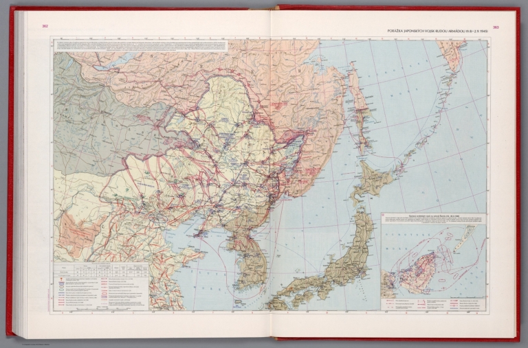
Porážka Japonských vojsk armádou (9.8 - 2.9. 1945). Československý vojenský atlas.
List No
13684.285
Note
Timeline map of the Pacific war, with inset: Russian operation in Shumshu Island. Includes text, table and legend. Showing defeat of Japanese troops by the army Aug. 8- Sept. 2, 1945
Author
News Map of the Week, Inc.
Full Title
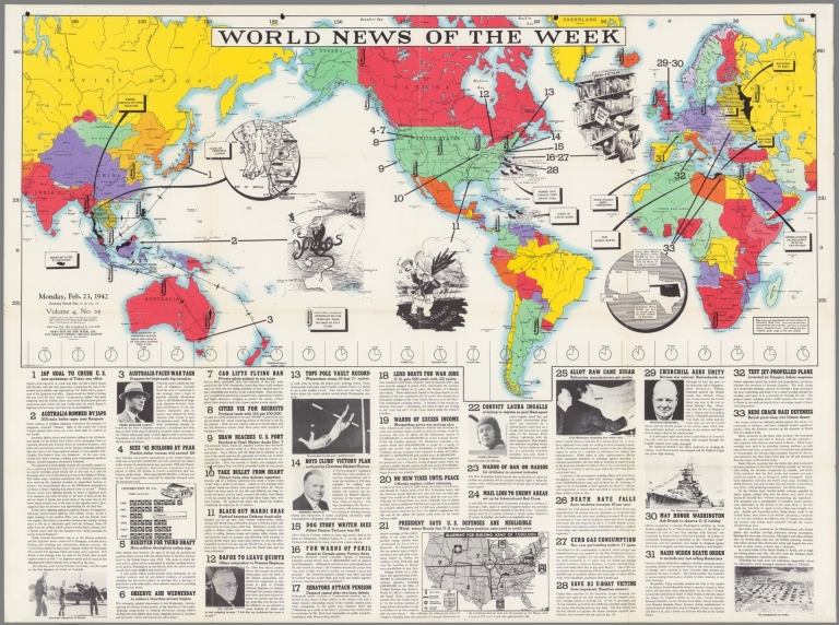
World News of the Week : Monday, Feb. 23, 1942. Covering period Feb. 13 to Feb. 19. Volume 4, No. 25. Published and copyrighted (weekly), 1942, by News Map of the Week, Inc., 1512 Orleans Street, Chicago, Illinois. Published in two sections : Section one. Lithographed in U. S. A.
List No
14087.000
Note
Lithographed world map, in color. Shows political boundaries and military events of World War II, from February 13 to 19, 1942. Relief illustrated with hachures. Includes legend indicating average February temperatures. Descriptive text throughout, e.g.: Four Italian ships torpedoed. Map indexed according to historical notes beneath map. Features photographs, illustrations, and international time zones. With four inset maps: Thailand -- (China) -- (Texas, New Mexico and Arizona) -- Blueprint for building Army of 700,000. Also, with diagram: Construction in U. S. Map is 56 x 115 cm, on sheet 89 x 120 cm, folded to 31 x 23 cm.
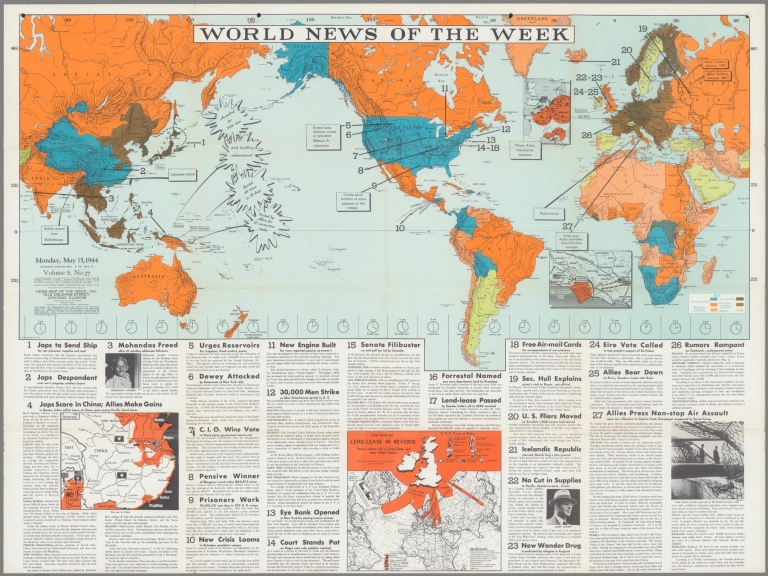
Author
News Map of the Week, Inc.
Full Title
World News of the Week : Monday, May 29, 1944. Covering period May 19 to May 25. Volume 6, No. 39. Published and copyrighted (weekly), 1944, by News Map of the Week, Inc., 1512 Orleans Street, Chicago, Illinois. Published in two sections : Section one. Lithographed in U. S. A.
List No
14174.000
Note
Lithographed world map, in color. Shows political boundaries and military events of World War II, from May 19 to 25, 1944. Relief illustrated with hachures. Descriptive text throughout, e.g.: Iceland, united to Denmark by personal bond with King Christian X, breaks tie with Denmark. Map indexed according to historical notes beneath map. Features photographs, illustrations, and international time zones. With three inset maps: (China) -- Position of Allied troops on the Italian front -- The roads to Rome. Map is 56 x 115 cm, on sheet 89 x 120 cm, folded to 31 x 23 cm.
Author
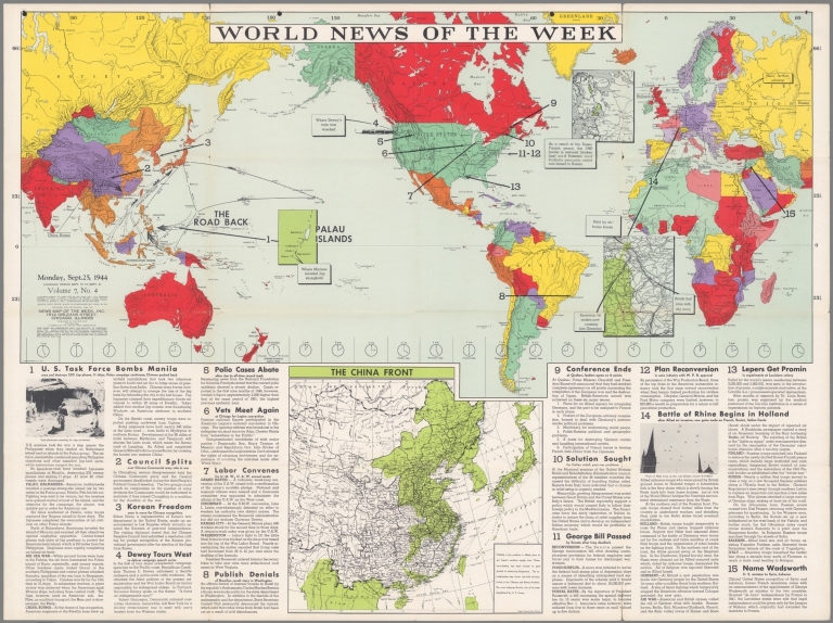
News Map of the Week, Inc.
Full Title
World News of the Week : Monday, Sept. 25, 1944. Covering period Sept. 15 to Sept. 21. Volume 7, No. 4. Published and copyrighted (weekly), 1944, by News Map of the Week, Inc., 1512 Orleans Street, Chicago, Illinois. Published in two sections : Section one. Lithographed in U. S. A.
List No
14179.000
Note
Lithographed world map, in color. Shows political boundaries and military events of World War II, from Sept. 15 to 21, 1944. Relief illustrated with hachures. Descriptive text throughout, e.g.: British 2nd joins with sky army. Map indexed according to historical notes beneath map. Features photographs, illustrations, and international time zones. With four inset maps: Palau Islands -- (Finland) -- (Border between Belgium and Germany) -- The China front. Map is 56 x 115 cm, on sheet 89 x 120 cm, folded to 31 x 23 cm.
Author
News Map of the Week, Inc.
Full Title
World News of the Week : Monday, Oct. 9, 1944. Covering period Sept. 29 to Oct. 9. Volume 7, No. 6. Published and copyrighted (weekly), 1944, by News Map of the Week, Inc., 1512 Orleans Street, Chicago, Illinois. Published in two sections : Section one. Lithographed in U. S. A.
List No
14181.000
Note
Lithographed world map, in color. Shows political boundaries and military events of World War II, from September 29 to October 9, 1944. Relief illustrated with hachures. Descriptive text throughout, e.g.: Allies invade Kythera. Map indexed according to historical notes beneath map. Features photographs, illustrations, and international time zones. With three inset maps: The Japanese advance in China -- (Border between The Netherlands and Germany) -- The Allied advance in Germany. Map is 56 x 115 cm, on sheet 89 x 120 cm, folded to 31 x 23 cm.
Author
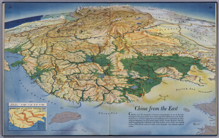
Harrison, Richard Edes
Full Title
China From the East. (drawn by) Richard Edes Harrison. 1941. (to accompany) Look At The World: The Fortune Atlas For world Strategy. By Richard Edes Harrison. Text by Editor of Fortune. New York: Alfred A. Knopf 1944. (on verso) Copyright 1944 by Time Incorporated.
List No
1970.026
Note
Full color shaded relief map. Includes text, inset maps showing Migration of Chinese universities, and Key to minerals. Atlas contains 66, (2) page text, index, statistics, color, and black and white maps (some folded) and plans. Covers are teal blue with the title "Look at the world: the Fortune Atlas For world Strategy. By Richard Edes Harrison. Text by Editor of Fortune. New York: Alfred A. Knopf." in center.
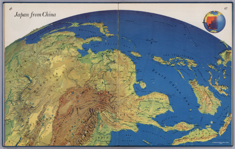
Author
Harrison, Richard Edes
Full Title
Japan From China. (drawn by) Richard Edes Harrison 1943. Copyright 1943. Time Inc. (to accompany) Look At The World: The Fortune Atlas For world Strategy. By Richard Edes Harrison. Text by Editor of Fortune. New York: Alfred A. Knopf 1944. (on verso) Copyright 1944 by Time Incorporated.
List No
1970.030
Note
Full color shaded relief map. Includes location map. Atlas contains 66, (2) page text, index, statistics, color, and black and white maps (some folded) and plans. Covers are teal blue with the title "Look at the world: the Fortune Atlas For world Strategy. By Richard Edes Harrison. Text by Editor of Fortune. New York: Alfred A. Knopf." in center.
Author
C.S. Hammond & Co.
Full Title
The Solomon Islands, The Bismarck Archipelago and Eastern New Guinea. India - Burma - China Theater of War.
List No
8758.002
Note
Date estimated. 3maps.
Author
[Civic Education Service, Coss, Tim, Perkins, Bill]
Full Title
Communist China. Headline-Focus Wall Map 15.
List No
9521.000
Author
Anonymous
Full Title
China.
List No
9792.000
Note
Shows areas of dispute, nuclear sites, and troop information.
1-37 of 37
|
![[Most Detailed Map of the War Situation].](https://www.davidrumsey.com/rumsey/Size2/RUMSEY~8~1/199/15075000.jpg)
![[First Sino-Japanese War. 1894 - 1895.]. 中日战争图. 1894 - 1895年. [Zhong Ri zhan zheng tu. 1894 - 1895 nian].](https://media.davidrumsey.com/MediaManager/srvr?mediafile=/Size3/RUMSEY~8~1/199/15078002.jpg)
![[Map of Peasant Rebellion during Late Qin Period]. 秦末农民战争图. [Qin mo nong min zhan zheng tu].](https://www.davidrumsey.com/rumsey/Size2/RUMSEY~8~1/199/15079002.jpg)
![[Situation Map of Kingdoms of the Spring and Autumn Period] 春秋列国形势图. [Chun qiu lie guo xing shi tu].](https://media.davidrumsey.com/MediaManager/srvr?mediafile=/Size3/RUMSEY~8~1/199/15080002.jpg)
![[Situation Map of the Yellow Turban Rebellion]. 黄巾起义形势图. [Huang jin qi yi xing shi tu].](https://www.davidrumsey.com/rumsey/Size2/RUMSEY~8~1/199/15081002.jpg)
![[Situation Map of National Protection Movement]. 护国运动形势图. [Hu guo yun dong xing shi tu].](https://media.davidrumsey.com/MediaManager/srvr?mediafile=/Size3/RUMSEY~8~1/199/15082002.jpg)
![[Situation Map of National Protection Movement]. 中国原始社会氏族公社遗址分布图. [Zhongguo yuan shi she hui shi zu gong she yi zhi fen bu tu].](https://media.davidrumsey.com/MediaManager/srvr?mediafile=/Size3/RUMSEY~8~1/199/15084002.jpg)
![Haikou Quantu 海口全圖 [Complete Map of Sea Ports].](https://media.davidrumsey.com/MediaManager/srvr?mediafile=/Size4/RUMSEY~8~1/195/15039003.jpg)