|
REFINE
Browse All : Military from 1944
1-154 of 154
Author
[United States. Army Service Forces. Army Information Branch., Harrison, Richard Edes]
Full Title
Newsmap For the Armed Forces. 276th Week of the War - 158th Week of U.S. Participation.
List No
15947.001
Note
Duplicate of 9014.000 but with mailing envelope added.
Author
United States. Army Service Forces. Army Information Branch.
Full Title
South Burma and Thailand. Prepared In The R and A Branch OSS.
List No
15947.002
Note
Duplicate of 9014.000 but with mailing envelope added.
Author
[United States. Army Service Forces. Army Information Branch., Harrison, Richard Edes]
Full Title
(Covers to) NEWSMAP Monday, 25 December, 1944
List No
15947.003
Note
Duplicate of 9014.000 but with mailing envelope added.
Author
News Map of the Week, Inc.
Full Title
World News of the Week : Monday, Apr. 10, 1944. Covering period Mar. 31 to Apr. 6. Volume 6, No. 32. Published and copyrighted (weekly), 1944, by News Map of the Week, Inc., 1512 Orleans Street, Chicago, Illinois. Published in two sections : Section one. Lithographed in U. S. A.
List No
14167.000
Note
Lithographed world map, in color. Shows political boundaries and military events of World War II, from March 31 to April 6, 1944. Relief illustrated with hachures. Includes a key indicating the alignment of warring nations (United, Axis, and neutral). Descriptive text throughout, e.g.: Budapest bombed by Allied planes. Map indexed according to historical notes beneath map. Features photographs, illustrations, and international time zones. With two inset maps: Reference chart for Pan-American Day, April 14, 1944 -- The Russian battlefront. Map is 56 x 115 cm, on sheet 89 x 120 cm, folded to 31 x 23 cm.
Author
News Map of the Week, Inc.
Full Title
World News of the Week : Monday, Apr. 24, 1944. Covering period Apr. 14 to Apr. 20. Volume 6, No. 34. Published and copyrighted (weekly), 1944, by News Map of the Week, Inc., 1512 Orleans Street, Chicago, Illinois. Published in two sections : Section one. Lithographed in U. S. A.
List No
14168.000
Note
Lithographed world map, in color. Shows political boundaries and military events of World War II, from April 14 to 20, 1944. Relief illustrated with hachures. Descriptive text throughout, e.g.: Where tornado struck. Map indexed according to historical notes beneath map. Features photographs, illustrations, and international time zones. With three inset maps: (Japanese advance in India) -- The size of the United States -- The Army's global airways. Map is 56 x 115 cm, on sheet 89 x 120 cm, folded to 31 x 23 cm.
Author
News Map of the Week, Inc.
Full Title
World News of the Week : Monday, May 8, 1944. Covering period Apr. 28 to May 4. Volume 6, No. 36. Published and copyrighted (weekly), 1944, by News Map of the Week, Inc., 1512 Orleans Street, Chicago, Illinois. Published in two sections : Section one. Lithographed in U. S. A.
List No
14170.000
Note
Lithographed world map, in color. Shows political boundaries and military events of World War II, from April 28 to May 4, 1944. Relief illustrated with hachures. Descriptive text throughout, e.g.: Ft. Norman - Whitehorse oil pipeline opened. Map indexed according to historical notes beneath map. Features photographs, illustrations, and international time zones. With inset map: (European communication networks). Also, with two diagrams: (Photo flash bomb) -- Bombing tons dropped on Axis Europe. Map is 56 x 115 cm, on sheet 89 x 120 cm, folded to 31 x 23 cm.
Author
News Map of the Week, Inc.
Full Title
World News of the Week : Monday, Mar. 13, 1944. Covering period Mar. 3 to Mar. 9. Volume 6, No. 28. Published and copyrighted (weekly), 1944, by News Map of the Week, Inc., 1512 Orleans Street, Chicago, Illinois. Published in two sections : Section one. Lithographed in U. S. A.
List No
14171.000
Note
Lithographed world map, in color. Shows political boundaries and military events of World War II, from March 3 to 9, 1944. Relief illustrated with hachures. Includes a key indicating the alignment of warring nations (United, Axis, and neutral). Descriptive text throughout, e.g.: Reds cut main Nazi supply line. Map indexed according to historical notes beneath map. Features photographs, illustrations, and international time zones. With two inset maps: (South America) -- (Berlin). Also, with diagram: The income tax and federal revenue. Map is 56 x 115 cm, on sheet 89 x 120 cm, folded to 31 x 23 cm.
Author
News Map of the Week, Inc.
Full Title
World News of the Week : Monday, May 15, 1944. Covering period May 5 to May 11. Volume 6, No. 37. Published and copyrighted (weekly), 1944, by News Map of the Week, Inc., 1512 Orleans Street, Chicago, Illinois. Published in two sections : Section one. Lithographed in U. S. A.
List No
14172.000
Note
Lithographed world map, in color. Shows political boundaries and military events of World War II, from May 5 to 11, 1944. Relief illustrated with hachures. Includes a key indicating the alignment of warring nations (United, Axis, and neutral). Descriptive text throughout, e.g.: Nazis note Anzio activities; flood Pontine Marshes. Map indexed according to historical notes beneath map. Features photographs, illustrations, and international time zones. With four inset maps: (Where Allies concentrate bombers in Europe) -- (Pontine Marshes) -- (China) -- Great Britain and Land-Lease in reverse. Map is 56 x 115 cm, on sheet 89 x 120 cm, folded to 31 x 23 cm.
Author
News Map of the Week, Inc.
Full Title
World News of the Week : Monday, Jan. 3, 1944. Covering period Dec. 24 to Dec. 30. Volume 6, No. 18. Published and copyrighted (weekly), 1944, by News Map of the Week, Inc., 1512 Orleans Street, Chicago, Illinois. Published in two sections : Section one. Lithographed in U. S. A.
List No
14152.000
Note
Lithographed world map, in color. Shows political boundaries and military events of World War II, from December 24 to 30, 1943. Relief illustrated with hachures. Descriptive text throughout, e.g.: Nazis lose three destroyers, other ships in Bay of Biscay. Map indexed according to historical notes beneath map. Features photographs, illustrations, and international time zones. With two inset maps: How New Britain compares in size with Massachusetts -- Scharnhorst. Also, with two diagrams: Total railroad mileage -- Saving the wounded. Map is 56 x 115 cm, on sheet 89 x 120 cm, folded to 31 x 23 cm.
Author
[Lajos, Kókai, István, Turner]
Full Title
Magyarorszag Légihelyzet Nyilvántartó Térképe [Air Situation Register Map of Hungary]
List No
15295.000
Author
Ogawa, Hikohei 小川彦平
Full Title
[Map of the Pacific. With a Detailed View of New Guinea and the Solomons] 太平洋周域地圖: 附ニューギニア東部及ソロモン諸島要圖 統撰. [Taiheiyō Shū-iki chizu: Fu nyūginia tōbu you Soromon shotō yōzu. Osamu sen].
List No
15085.002
Author
Ogawa, Hikohei 小川彦平
Full Title
(Blank map of the Western Pacific)
List No
15085.003
Note
Blank map for users to fill in details of the ongoing war.
Author
Aspioti-ELKA (Firm)
Full Title
ΣYNOΛIKEΣ AΠΩΛEIEΣ OIKOΔOMΩN KATA AITIA : KATA TH KATOXH 1941-1944.
List No
14295.134
Note
Colored chart representing Greece, showing the destruction of buildings from 1941 to 1944. Delineates between different forms of damage, such as arson and looting, as well as perpetrators, including the Germans, Italians, Bulgarians and allied powers. Includes a legend. Accompanied by descriptive text on facing page in Greek, French, English and Russian, entitled, Total of damage to buildings. Description begins: All these destructions cost Greece the loss of 400,000 buildings, amounting to 23% of her wealth in buildings. Thus, Greece has paid the highest price amongst the allies ... Chart is 29 x 44 cm, on sheet 35 x 47 cm. (Plate number 60, according to descriptive text.) Within the fifth section of the atlas, Damage to towns and villages.
Author
Blake, F. Donald
Full Title
Britain - Spearhead of attack. F. Donald Blake. Printed in England by Alf Cooke Ltd., Leeds and London.
List No
14074.000
Note
Pictorial military map of the Great Britain, and part of Europe. Shows battle sites and locations of resources, such as electric power, coal and tanks. Includes a legend and descriptive text, as well as a decorative title cartouche. With inset: (Turin; Milan; Genoa). Map is 45 x 70 cm, on sheet 51 x 76 cm. For Italian edition of map in Collection, see Pub List No. 14075.000. (Date estimated.)
Author
Blake, F. Donald
Full Title
Gran Bretagna - la posizione avanzata dell'attacco. F. Donald Blake. (Printed in England by Alf Cooke Ltd., Leeds and London.)
List No
14075.000
Note
Pictorial military map of the Great Britain, and part of Europe. Shows battle sites and locations of resources, such as electric power, coal and tanks. Includes a legend and descriptive text, as well as a decorative title cartouche. With inset: (Turin; Milan; Genoa). Map is 45 x 70 cm, on sheet 51 x 76 cm. For English edition of map in Collection, see Pub List No. 14074.000. (Imprint taken from 14074.000. Date estimated.)
Author
Chapin, Jr., R.M.
Full Title
I have returned. TIME map by R.M. Chapin, Jr. For report documenting above map see TIME, October 30, 1944 issue.
List No
11770.000
Note
2 color maps on 1 sheet. "Enlargement of original map drawn for TIME The weekly magazine.". R.M. Chapin Jr. was a prominent Cold War cartographer who worked for Time Magazine. Relief shown by shading.
Author
Chapin, Jr., R.M.
Full Title
Choking Chungking. TIME map by R.M. Chapin, Jr. For report documenting above map see Time, Decmeber 11, 1944 issue.
List No
11771.000
Note
Color map. "Enlargement of original map drawn for TIME The weekly magazine.". R.M. Chapin Jr. was a prominent Cold War cartographer who worked for Time Magazine. Relief shown by shading.
Author
Cutter, James
Full Title
Wreckers at work. TIME map by James Cutter. For report documenting above map see Time, July 17, 1944 issue.
List No
11774.000
Note
Color map. "Enlargement of original map drawn for TIME The weekly magazine." Shows Soviet offensives on German-held Poland.
Author
[Manning, F. E., Kaltenborn, H. V., Pure Oil Company.]
Full Title
Global war in the Pacific, to show progress and latest advances of the allies ... Copyright 1944, the Pure Oil Company. All maps designed and executed by F.E. Manning. (insets) View of Pacific showing territories and possessions of warning nations ... December 7, 1941. (with) View of Pacific showing Tokyo as the central target. (cover title) Pacific War maps. Edited by H v Kaltenborn ...
List No
11572.002
Note
Color map on 1 sheet 99x128, folded. Includes 2 inset maps. Showing naval and air bases, roads, railroads rivers, mountains and distances. Relief shown by shadings; depth shown by bathymetric tints.
Author
[Albert Richard Sportswear, Cheeseman, F.E.]
Full Title
Wings over the World ... Yesterday, Today and Tomorrow. Aviation Calvacade, by Albert Richard Sportswear.
List No
12371.001
Author
[Los Angeles Times, Owens, Charles H.]
Full Title
Saipan conquest sets pattern for vast aerial operations. Los Angeles Times. Monday July 10, 1944.
List No
8067.000
Note
Color pictorial map by Charles Owens, mounted on Japanese paper. Showing the war in the Pacific. The capture of the strategic island of Saipan is illustrated, with a description in the text at upper right: "American conquest of Saipan in the Marianas has completed a pattern for aerial operations of overwhelming dimensions. Military experts envisage bombing flights, principally those of the new B-29 Superfortresses, originating from Saipan and ranging as far as Japan, Formosa, the China coast and the Philippines." Also shows that range, with other centers of aerial operation: the Admiralty Islands north of New Guinea and Chungking in China. Informative text labels provide an effective overview of the geopolitical situation, in keeping with the "air-age". "Red tint indicates Jap held areas".
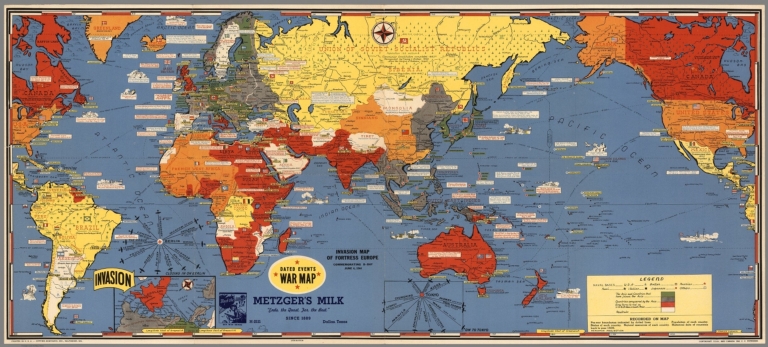
Author
[Turner, Stanley, Petersen, C.C.]
Full Title
Dated Events. On To Tokyo. Map of the Pacific and the Far East. Stanley Turner, 44. Copyright, Canada and U.S.A., 1944, C.C. Petersen, Publishing and Advertising, Toronto, Canada. Seventh Edition.
List No
6828.000
Note
Color map, seventh edition, showing the latest activity in the Pacific Arena. On sheet 51x 66, folded as issued. Date of 1944 in marker at lower left corner. Note below title: "With this invasion map you will be able to follow the progress of the Allied armies on their way to smash Japan ..." Legend includes: American, British, Russian and Japanese Naval Bases are shown; land areas are colored to show countries under Anglo-American control, those retaken from Japan, and those under Japanese control. A fascinating map packed with information on battle dates and illustrations. Relief shown pictorially. From the collection of John Oram.
Author
[Owens, Charles H., Los Angeles Times]
Full Title
Russian fleet poised to slash Nazis' Baltic Sea Routes. Los Angeles Times. Monday Feb. 28,1944 - Part I, 3.
List No
11006.000
Note
Color map, by Charles Owens "This sketch map by Charles Owens illustrates possible Russian fleet movements across Germany's shipping lines in the Baltic. Map packed with information on battle fields and allied activities. Shows boundaries, major cities, railroads, distances, Russian fleet lines, and Germany's Baltic trade and supply routes. Relief shown pictorially. Includes text.
Author
[Owens, Charles H., Los Angeles Times]
Full Title
MacArthur moves into position for assault on Philippines. Los Angeles Times. Monday Mar. 6, 1944 - Part I, 3.
List No
11007.000
Note
Color map, by Charles Owens "A stroke toward Mindanao not only would isolate the Japs' southwestern empire but would serve to protect the flank of Adm. Nimitz's forces... Charles Owens' map illustrate the possibilities of such tactic." Map packed with information on battle fields and allied activities. Shows major cities, distances, arrow indicates general direction of warplanes and fleets approaching Philippines. Relief shown pictorially. Includes text.
Author
[Los Angeles Times, Owens, Charles H.]
Full Title
Japs move fast to forestall allied offensive in China. Charles Owens, Los Angeles Times. Los Angeles Times, Monday, Dec. 18, 1944 - Part 3.
List No
11025.000
Note
Color map, with detailed view air strikes at upper panel. Covers China, Korea and part of Japan and Burma. Shows lines of air attack, major cities, allied air bases, distances, etc. Relief shown pictorially. Includes historical notes and text.
Author
[Los Angeles Times, Owens, Charles H.]
Full Title
British fleet threatens Japanese supply lines to Asia. Map by Charles Owens. Los Angeles Times, Monday, Nov. 6, 1944 - Part 3.
List No
11026.000
Note
Color map, with detailed view of battleships at upper panel. Shows patterns of attack, supply lines, major cities, ports, railroads, etc. Includes compass rose at lower right, historical notes and text.
Author
[Los Angeles Times, Owens, Charles H.]
Full Title
Bombers over Philippines Herald MacArthur's approach. Los Angeles Times, Monday, Aug. 14, 1944 - Part 3.
List No
11027.000
Note
Color map, with view of horizon at upper panel. Shows lines of attack, major cities, air bases, distances, etc. Relief shown pictorially. Includes historical notes and text :"This map is perspective by Charles Owens locates MacArthur's position of Sansapor and shows Halmahera lying astride his route to the Philippines".
Author
[Los Angeles Times, Owens, Charles H.]
Full Title
Key cities of Rhineland within reach of allied armies. By Charles Owens, Los Angeles Times. Los Angeles Times, Monday, Sept. 11, 1944 - Part 3.
List No
11028.000
Note
Color map, with views of horizon at upper panel and air attack in Germany. Shows major cities, buildings, roads, railroads, etc. Relief shown pictorially. Includes compass rose at lower left, historical notes and text :"Allied forces, as illustrated in Charles Owens's map, are driving at major German cities ..."
Author
[Los Angeles Times, Owens, Charles H.]
Full Title
MacArthur's invaders strike into heart of Jap defenses. Map by Charles Owens. Los Angeles Times, Monday, Oct. 23, 1944 - Part 3.
List No
11029.000
Note
Color map, with views of horizon at upper panel. Shows lines of attack, major cities, roads, lines of supplies by land and sea, prison camps, air bases, etc. Relief shown pictorially. Includes historical notes and text :"The inset map illustrates the Jap movement in China which is creating a barrier between the Allies in India-Burma and American forces in the Pacific ..."
Author
[Los Angeles Times, Owens, Charles H.]
Full Title
Where faltering Wehmacht may be struck mortal blow. By Charles Owens. Los Angeles Times, Monday, Nov. 27, 1944 - Part 3.
List No
11030.000
Note
Color map, with views of horizon at upper panel. Shows lines of attack by air, major cities, roads, railroads, army bases, etc. Relief shown pictorially. Includes compass rose, historical notes and text.
Author
Los Angeles Times
Full Title
U.S. sea and air power trained on Japan home land. Los Angeles times. Monday, June 26, 1944 - Part 3. (inset map).
List No
11033.000
Note
Color map. Shows Japan's major cities, roads, railroads, industrial areas, etc. Relief shown pictorially. Includes historical notes and text. Inset map: "The sea-air battle near the Philippines in water that wash Japan's southeastern shores brought the war home to the enemy from that quarter ..."
Author
[Los Angeles Times, Owens, Charles H.]
Full Title
Day of reckoning near for Jap conquerors of Philippines. Los Angeles times. Monday, Aug. 28, 1944 - Part 3. (inset) Philippine Islands.
List No
11034.000
Note
Color map, with views of horizon at upper panel. Shows major cities, army bases, attack lines, prison camps, distances, etc. Relief shown pictorially. Includes historical notes and text: "Charles Owens' map of the islands locates the sites of prison camps and illustrates, with arrow how the enemy took Manila."
Author
Los Angeles Times
Full Title
Finish of Hungary, Hitler's last major satellite, in sight. Los Angeles times. Monday, Nov. 13, 1944 - Part 3.
List No
11038.000
Note
Color map. Shows lines of attack, German defensive lines, army bases, major cities, rivers, railroads, etc. Relief shown pictorially. Includes historical notes and text.
Author
Los Angeles Times
Full Title
Allies make mighty bid for victory on the western front. Los Angeles times. Monday, Nov. 20, 1944 - Part 3.
List No
11039.000
Note
Color map. Shows lines of attack, army bases, major cities, rivers, railroads, etc. Relief shown pictorially. Includes historical notes and text: "Six allied armies are driving ahead on a 400-mile line in what may develop into the last great offensive on the western front." .
Author
Los Angeles Times
Full Title
Will United states keep island bases to guard Pacific? Los Angeles times. Monday, Sept. 3, 1944 - Part 3.
List No
11040.000
Note
Color map, with view of horizon on top panel. Shows army bases, major cities, etc. Relief shown pictorially. Includes historical notes and text.
Author
Los Angeles Times
Full Title
Pacific war sweeps to Japan's immediate islands outposts. Los Angeles times. Monday, Sept. 25, 1944 - Part 3.
List No
11041.000
Note
Color map of North Pacific Ocean Islands, with view of horizon on top panel. Shows lines of air attacks, army bases, major cities, Japan supply line, distances, etc. Includes historical notes and text.
Author
[Manning, F. E., Kaltenborn, H. V., Pure Oil Company.]
Full Title
Southeast Asia (Scale: ca. 1:5,500,000). Japan (Scale: ca. 2,450,000). Northeast China and Japan (Scale: ca. 1:5,300,000). Philippines (Scale: ca. 5,500,000). (inset diagram). All maps designed and executed by F.E. Manning. (cover title) Pacific War maps. Edited by H v Kaltenborn ...
List No
11572.003
Note
4 color maps on 1 sheet, folded. With inset diagram. Showing naval and air bases, roads, railroads rivers, mountains and distances. Relief shown by shadings; depth shown by bathymetric tints.
Author
[Utley, Clifton, Skelly Oil Company]
Full Title
(Text Page to) War map of the Pacific and Far East : Complements of your neighborhood Skellyman. Skelly. (on verso) Know your Navy.
List No
11694.001
Note
Color map of the Pacific, folded. Shows territorial divisions, military bases, air mileage, aid routes, and time zones. Includes legend, text, time zones, territorial divisions, military bases, air mileage, aid routes, railroads, distances, and radio listings for Clifton Utley's news broadcasts. On verso: charts and detailed pictorial and text definition of Navy warships, aircraft. and world fleets. Date estimated.
Author
[Utley, Clifton, Skelly Oil Company]
Full Title
War map of the Pacific and Far East : Complements of your neighborhood Skellyman. Skelly. (on verso) Know your Navy.
List No
11694.002
Note
Color map of the Pacific, folded. Shows territorial divisions, military bases, air mileage, aid routes, and time zones. Includes legend, text, time zones, territorial divisions, military bases, air mileage, aid routes, railroads, distances, and radio listings for Clifton Utley's news broadcasts. On verso: charts and detailed pictorial and text definition of Navy warships, aircraft. and world fleets. Date estimated.
Author
Sundberg, Edwin L.
Full Title
Camp Grounds of the Nation (eastern half). January 2, 1944.
List No
12262.000
Note
Western half missing.
Author
Sundberg, Edwin L.
Full Title
Invasion Land. February 20, 1944.
List No
12263.000
Author
Sundberg, Edwin L.
Full Title
Invasion Land. February 27, 1944.
List No
12264.000
Author
Sundberg, Edwin L.
Full Title
Quadruple Threat to Japan. September 3, 1944.
List No
12269.000
Author
Sundberg, Edwin L.
Full Title
France the Battleground. November 26,1944.
List No
12271.000
Author
Sundberg, Edwin L.
Full Title
"I Have Returned' [General MacArthur]. December 3, 1944.
List No
12272.000
Author
Sundberg, Edwin L.
Full Title
Inside the Inner Fortress. December 17, 1944.
List No
12273.000
Author
Sundberg, Edwin L.
Full Title
3 Years of War. December 31, 1944.
List No
12274.000
Author
Air Transport Association
Full Title
Arteries of Defense.
List No
12369.000
Note
Date estimated.
Author
[Albert Richard Sportswear, Cheeseman, F.E.]
Full Title
(Text page to) Wings over the World ... Yesterday, Today and Tomorrow. Aviation Calvacade, by Albert Richard Sportswear.
List No
12371.002
Author
Turner, Stanley
Full Title
War in Europe Dated Events. Keep up-to-date. 6th edition. Win the war in 1944. (on verso: Map of the Pacific Arena). Stanley Turner. International Circulation Company, Inc., New York City. Copyright, Canada and U.S.A. 1944, C.C. Petersen, Publishing and advertising, Toronto, Ont.
List No
13489.002
Author
Turner, Stanley
Full Title
(Map of the Pacific Arena). (on verso) War in Europe Dated Events. Keep up-to-date. 6th edition. Win the war in 1944. Stanley Turner. International Circulation Company, Inc., New York City. Copyright, Canada and U.S.A. 1944, C.C. Petersen, Publishing and advertising, Toronto, Ont.
List No
13489.003
Author
Turner, Stanley
Full Title
War in Europe Dated Events. (WWII Pacific theaters of War). Stanley Turner. Printed in U.S.A. International circulation Company, Inc., New York City. Copyright, Canada and U.S.A. 1944, C.C. Peterson, publishing and advertising, Toronto, ONT.
List No
13579.001
Author
Turner, Stanley
Full Title
(WWII Pacific theaters of War). War in Europe Dated Events. Stanley Turner. Printed in U.S.A. International circulation Company, Inc., New York City. Copyright, Canada and U.S.A. 1944, C.C. Peterson, publishing and advertising, Toronto, ONT.
List No
13579.002
Author
Rand McNally & Co.
Full Title
Rand McNally Invastion Issue Global war map : New revised edition.
List No
14065.001
Note
Covers to pocket military map for World War II (in three parts: Europe, Eastern Hemisphere, South Pacific), in color. Cover includes image of partial globe surrounded by military planes. Folded to 23 x 10 cm.
Author
Rand McNally & Co.
Full Title
Rand McNally map of the European battle areas. Copyright by Rand McNally & Company, Chicago.
List No
14065.002
Note
Pocket military map of Europe during World War II, in color. Shows political boundaries, battle areas, as well as air and sea distances.. Includes a legend and a bar scale. (Maps of Eastern Hemisphere and the South Pacific on verso.) Map is 48 x 65 cm, on sheet 50 x 68 cm, folded to 23 x 10 cm.
Author
Rand McNally & Co.
Full Title
Rand McNally map of the Eastern Hemisphere -- Rand McNally map of the South Pacific. Copyright by Rand McNally & Company, Chicago.
List No
14065.003
Note
Pocket military map of Eastern Hemisphere (scale 1:80,000,000; 43 x 48 cm) and the South Pacific (scale 1:20,000,000; 21 x 28 cm) during World War II, in color. Maps show political boundaries, battle areas, as well as air and sea distances. Each map includes a legend and a bar scale. (Map of Europe on verso.) On sheet 58 x 60 cm, folded to 23 x 10 cm.
Author
Industrial Services Division, Bureau of Public Relations, War Department
Full Title
Newsmap : Monday, January 3, 1944. Week of December 22 to December 29, 225th week of the War - 107th week of U. S. participation. Volume II No. 37. Distributed by Industrial Services Division, Bureau of Public Relations, War Department. Prepared from public sources of information. U. S. Government Printing Office: 1943.
List No
14153.000
Note
Three lithographed maps, in black, gray and teal. Maps show political boundaries, roads, and rivers. Geography selected to depict military events of World War II, from December 22 to 29, 1943. Maps: (Rome to Naples, Italy) (41 x 57 cm) -- (Strait of Dover) (16 x 25 cm) -- (Northern Scandinavia) (11 x 13 cm). Each map includes a bar scale; first includes a legend. Accompanying historical notes describe the war fronts: New Britain -- Air offensive -- USSR -- Italy -- Scharnhorst -- Command. Features photographs. Sheet 89 x 120 cm, folded to 31 x 23 cm. Stamp on verso: Received Jan 6 1944 C. E. King.
Author
News Map of the Week, Inc.
Full Title
World News of the Week : Monday, Jan. 10, 1944. Covering period Dec. 31 to Jan. 6. Volume 6, No. 19. Published and copyrighted (weekly), 1944, by News Map of the Week, Inc., 1512 Orleans Street, Chicago, Illinois. Published in two sections : Section one. Lithographed in U. S. A.
List No
14154.000
Note
Lithographed world map, in color. Shows political boundaries and military events of World War II, from December 31 to January 6, 1944. Relief illustrated with hachures. Descriptive text throughout, e.g.: Allied armies halted by snow, mud. Map indexed according to historical notes beneath map. Features photographs, illustrations, and international time zones. With eleven inset maps: Jaluit -- Wotje -- Maloelap -- Russo-German fronts : Jan. 1, 1938 -- Sept. 28, 1939 -- June 27, 1940 -- June 27, 1941 -- Dec. 5, 1941 -- June 16, 1942 -- Jan. 1, 1943 -- Jan. 4, 1944. Map is 56 x 115 cm, on sheet 89 x 120 cm, folded to 31 x 23 cm.
Author
News Map of the Week, Inc.
Full Title
World News of the Week : Monday, Jan. 17, 1944. Covering period Jan. 7 to Jan. 13. Volume 6, No. 20. Published and copyrighted (weekly), 1944, by News Map of the Week, Inc., 1512 Orleans Street, Chicago, Illinois. Published in two sections : Section one. Lithographed in U. S. A.
List No
14155.000
Note
Lithographed world map, in color. Shows political boundaries and military events of World War II, from January 7 to 13, 1944. Relief illustrated with hachures. Includes a key indicating the alignment of warring nations (United, Axis, and neutral). Descriptive text throughout, e.g.: Attacked in raid which cost U. S. 64 planes. Map indexed according to historical notes beneath map. Features photographs, illustrations, and international time zones. With three inset maps: Burma -- Poland -- Italy. Also, with two diagrams: America's manpower pool -- Jet-propelled aircraft. Map is 56 x 115 cm, on sheet 89 x 120 cm, folded to 31 x 23 cm.
Author
Industrial Services Division, Bureau of Public Relations, War Department
Full Title
Newsmap : Monday, January 10, 1944. Week of December 29 to January 5, 1944, 226th week of the War - 108th week of U. S. participation. Volume II No. 38. Distributed by Industrial Services Division, Bureau of Public Relations, War Department. Prepared from public sources of information. U. S. Government Printing Office: 1944.
List No
14157.000
Note
Five lithographed maps, in black, blue and white. Maps show political boundaries, rivers, and railways. Geography selected to depict military events of World War II, from December 29 to January 5, 1944. Maps: (New Britain I.) (26 x 71 cm, scale 1:1,750,000) -- (Italy) (43 x 43 cm, scale 1:750,000) -- (Cassino) (17 x 27 cm, scale 1:175,000) -- (Chieti) (23 x 27 cm, scale 1:175,000) -- (Border between Poland and Russia) (23 x 27 cm, scale 1:1,000,000). Each map includes a bar scale. Accompanying historical notes describe the war fronts: USSR -- Southwest Pacific -- Italy -- Air offensive. Features photographs. Sheet 89 x 120 cm, folded to 31 x 23 cm. Stamp on verso: Received Jan 12 1943 C. E. King.
Author
News Map of the Week, Inc.
Full Title
World News of the Week : Monday, Feb. 7, 1944. Covering period Jan. 28 to Feb. 3. Volume 6, No. 23. Published and copyrighted (weekly), 1944, by News Map of the Week, Inc., 1512 Orleans Street, Chicago, Illinois. Published in two sections : Section one. Lithographed in U. S. A.
List No
14158.000
Note
Lithographed world map, in color. Shows political boundaries and military events of World War II, from January 28 to February 3, 1944. Relief illustrated with hachures. Descriptive text throughout, e.g.: Lagoon could harbor huge fleet. Map indexed according to historical notes beneath map. Features photographs, illustrations, and international time zones. With four inset maps: Kwajalein -- Wotje -- Maloelap -- Italy. Map is 56 x 115 cm, on sheet 89 x 120 cm, folded to 31 x 23 cm.
Author
News Map of the Week, Inc.
Full Title
World News of the Week : Monday, Feb. 14, 1944. Covering period Feb. 4 to Feb. 10. Volume 6, No. 24. Published and copyrighted (weekly), 1944, by News Map of the Week, Inc., 1512 Orleans Street, Chicago, Illinois. Published in two sections : Section one. Lithographed in U. S. A.
List No
14159.000
Note
Lithographed world map, in color. Shows political boundaries and military events of World War II, from February 4 to 10, 1944. Relief illustrated with hachures. Includes a key indicating the alignment of warring nations (United, Axis, and neutral). Descriptive text throughout, e.g.: Nazi bridgeheads wiped out. Map indexed according to historical notes beneath map. Features photographs, illustrations, and international time zones. With two inset maps: (Rome) -- (Paramushiro Island). Map is 56 x 115 cm, on sheet 89 x 120 cm, folded to 31 x 23 cm.
Author
News Map of the Week, Inc.
Full Title
World News of the Week : Monday, Feb. 21, 1944. Covering period Feb. 11 to Feb. 17. Volume 6, No. 25. Published and copyrighted (weekly), 1944, by News Map of the Week, Inc., 1512 Orleans Street, Chicago, Illinois. Published in two sections : Section one. Lithographed in U. S. A.
List No
14160.000
Note
Lithographed world map, in color. Shows political boundaries and military events of World War II, from February 11 to 17, 1944. Relief illustrated with hachures. Descriptive text throughout, e.g.: Reds close in on trapped Nazis. Map indexed according to historical notes beneath map. Features photographs, illustrations, and international time zones. With inset map: (New Guinea, including New Britain Island). Map is 56 x 115 cm, on sheet 89 x 120 cm, folded to 31 x 23 cm.
Author
News Map of the Week, Inc.
Full Title
World News of the Week : Monday, Feb. 28, 1944. Covering period Feb. 18 to Feb. 24. Volume 6, No. 26. Published and copyrighted (weekly), 1944, by News Map of the Week, Inc., 1512 Orleans Street, Chicago, Illinois. Published in two sections : Section one. Lithographed in U. S. A.
List No
14161.000
Note
Lithographed world map, in color. Shows political boundaries and military events of World War II, from February 18 to 24, 1944. Relief illustrated with hachures. Descriptive text throughout, e.g.: Allies gain on beachhead, continue to fight in Cassino. Map indexed according to historical notes beneath map. Features photographs, illustrations, and international time zones. With inset map: Eniwetok. Also, with a diagram: The Nazis' Junkers Jumo 211 J; as well as two tables: The battle score : Japanese losses; U. S. Pacific Losses -- The record : Planes participating; Planes lost. Map is 56 x 115 cm, on sheet 89 x 120 cm, folded to 31 x 23 cm.
Author
News Map of the Week, Inc.
Full Title
World News of the Week : Monday, Mar. 6, 1944. Covering period Feb. 25 to Mar. 2. Volume 6, No. 27. Published and copyrighted (weekly), 1944, by News Map of the Week, Inc., 1512 Orleans Street, Chicago, Illinois. Published in two sections : Section one. Lithographed in U. S. A.
List No
14162.000
Note
Lithographed world map, in color. Shows political boundaries and military events of World War II, from February 25 to March 2, 1944. Relief illustrated with hachures. Descriptive text throughout, e.g.: Bulgaria reported ready to quit war. Map indexed according to historical notes beneath map. Features photographs, illustrations, and international time zones. With inset map: (German military presence in and withdrawal from Scandinavia). Also, with diagram: Automatic antiaircraft fire. Map is 56 x 115 cm, on sheet 89 x 120 cm, folded to 31 x 23 cm.
Author
News Map of the Week, Inc.
Full Title
World News of the Week : Monday, Apr. 17, 1944. Covering period Apr. 7 to Apr. 13. Volume 6, No. 33. Published and copyrighted (weekly), 1944, by News Map of the Week, Inc., 1512 Orleans Street, Chicago, Illinois. Published in two sections : Section one. Lithographed in U. S. A.
List No
14163.000
Note
Lithographed world map, in color. Shows political boundaries and military events of World War II, from April 7 to 13, 1944. Relief illustrated with hachures. Descriptive text throughout, e.g.: Range of U. S. bombers as indicated by raid on Marienburg, East Prussia. Map indexed according to historical notes beneath map. Features photographs, illustrations, and international time zones. With two inset maps: (Sevastopol) -- The Pacific Front. Also, with diagram: Automatic antiaircraft fire. Map is 56 x 115 cm, on sheet 89 x 120 cm, folded to 31 x 23 cm.
Author
News Map of the Week, Inc.
Full Title
World News of the Week : Monday, Mar. 20, 1944. Covering period Mar. 10 to Mar. 16. Volume 6, No. 29. Published and copyrighted (weekly), 1944, by News Map of the Week, Inc., 1512 Orleans Street, Chicago, Illinois. Published in two sections : Section one. Lithographed in U. S. A.
List No
14164.000
Note
Lithographed world map, in color. Shows political boundaries and military events of World War II, from March 10 to 16, 1944. Relief illustrated with hachures. Descriptive text throughout, e.g.: British curb Irish travel. Map indexed according to historical notes beneath map. Features photographs, illustrations, and international time zones. With inset map: The air war against Germany. Map is 56 x 115 cm, on sheet 89 x 120 cm, folded to 31 x 23 cm.
Author
News Map of the Week, Inc.
Full Title
World News of the Week : Monday, Mar. 27, 1944. Covering period Mar. 17 to Mar. 23. Volume 6, No. 30. Published and copyrighted (weekly), 1944, by News Map of the Week, Inc., 1512 Orleans Street, Chicago, Illinois. Published in two sections : Section one. Lithographed in U. S. A.
List No
14165.000
Note
Lithographed world map, in color. Shows political boundaries and military events of World War II, from March 17 to 23, 1944. Relief illustrated with hachures. Descriptive text throughout, e.g.: Red drive into Rumania threatens all Balkans. Map indexed according to historical notes beneath map. Features photographs, illustrations, and international time zones. With four inset maps: Hukawng Valley -- Mili -- (Cassino) -- Russia's drive into Rumania. Map is 56 x 115 cm, on sheet 89 x 120 cm, folded to 31 x 23 cm.
Author
News Map of the Week, Inc.
Full Title
World News of the Week : Monday, Apr. 3, 1944. Covering period Mar. 24 to Mar. 30. Volume 6, No. 31. Published and copyrighted (weekly), 1944, by News Map of the Week, Inc., 1512 Orleans Street, Chicago, Illinois. Published in two sections : Section one. Lithographed in U. S. A.
List No
14166.000
Note
Lithographed world map, in color. Shows political boundaries and military events of World War II, from March 24 to 30, 1944. Relief illustrated with hachures. Descriptive text throughout, e.g.: Stockholm press reports arrival of Nazi troops in Finland. Map indexed according to historical notes beneath map. Features photographs, illustrations, and international time zones. With six inset maps: (Romania) -- Burma : Population, area; Products; Rainfall; Roads. Map is 56 x 115 cm, on sheet 89 x 120 cm, folded to 31 x 23 cm.
Author
News Map of the Week, Inc.
Full Title
World News of the Week : Monday, May 1, 1944. Covering period Apr. 21 to Apr. 27. Volume 6, No. 35. Published and copyrighted (weekly), 1944, by News Map of the Week, Inc., 1512 Orleans Street, Chicago, Illinois. Published in two sections : Section one. Lithographed in U. S. A.
List No
14169.000
Note
Lithographed world map, in color. Shows political boundaries and military events of World War II, from April 21 to 27, 1944. Relief illustrated with hachures. Descriptive text throughout, e.g.: New York-to-Ireland speed record set by 30-ton U. S. transport. The time, 15 hours, 51 minutes. Map indexed according to historical notes beneath map. Features photographs, illustrations, and international time zones. With three inset maps: Recapture of Crimea opens new vista -- The war on New Guinea -- The air war against Germany. Map is 56 x 115 cm, on sheet 89 x 120 cm, folded to 31 x 23 cm.
Author
News Map of the Week, Inc.
Full Title
World News of the Week : Monday, May 22, 1944. Covering period May 12 to May 18. Volume 6, No. 38. Published and copyrighted (weekly), 1944, by News Map of the Week, Inc., 1512 Orleans Street, Chicago, Illinois. Published in two sections : Section one. Lithographed in U. S. A.
List No
14173.000
Note
Lithographed world map, in color. Shows political boundaries and military events of World War II, from May 12 to 18, 1944. Relief illustrated with hachures. Descriptive text throughout, e.g.: R. A. F. plane crosses Atlantic in 6 hr., 45 min. - first Atlantic flight 25 years before took 26 hr., 51 min. Map indexed according to historical notes beneath map. Features photographs, illustrations, flight paths, and international time zones. With three inset maps: (Burma) -- (Buthedaung) -- War in Italy. Map is 56 x 115 cm, on sheet 89 x 120 cm, folded to 31 x 23 cm.
Author
News Map of the Week, Inc.
Full Title
World News of the Week : Monday, May 29, 1944. Covering period May 19 to May 25. Volume 6, No. 39. Published and copyrighted (weekly), 1944, by News Map of the Week, Inc., 1512 Orleans Street, Chicago, Illinois. Published in two sections : Section one. Lithographed in U. S. A.
List No
14174.000
Note
Lithographed world map, in color. Shows political boundaries and military events of World War II, from May 19 to 25, 1944. Relief illustrated with hachures. Descriptive text throughout, e.g.: Iceland, united to Denmark by personal bond with King Christian X, breaks tie with Denmark. Map indexed according to historical notes beneath map. Features photographs, illustrations, and international time zones. With three inset maps: (China) -- Position of Allied troops on the Italian front -- The roads to Rome. Map is 56 x 115 cm, on sheet 89 x 120 cm, folded to 31 x 23 cm.
Author
News Map of the Week, Inc.
Full Title
World News of the Week : Monday, June 5, 1944. Covering period May 26 to June 1. Volume 6, No. 40. Published and copyrighted (weekly), 1944, by News Map of the Week, Inc., 1512 Orleans Street, Chicago, Illinois. Published in two sections : Section one. Lithographed in U. S. A.
List No
14175.000
Note
Lithographed world map, in color. Shows political boundaries and military events of World War II, from May 26 to June 1, 1944. Relief illustrated with hachures. Descriptive text throughout, e.g.: U. S. troops move westward on Biak Island. Map indexed according to historical notes beneath map. Features photographs, illustrations, and international time zones. With two inset maps: The lineup in Yugoslavia -- Rome line fortified against Allied drive. Also, with diagram: LST, an invasion tool, shown in diagrammatic form. Map is 56 x 115 cm, on sheet 89 x 120 cm, folded to 31 x 23 cm.
Author
[Bauer, Hubert A. (Hubert Anton), 1886-, American Airlines Inc., Carl Byoir & Associates, News Map of the Week, Inc.]
Full Title
World News of the Week : Monday, Sept. 4, 1944. Covering period Aug. 25 to Aug 31. Volume 7, No. 1. Published and copyrighted (weekly), 1944, by News Map of the Week, Inc., 1512 Orleans Street, Chicago, Illinois. Published in three sections : Section one. Cartographer, H. A. Bauer. Base map copyrighted by American Airlines, Inc. Photos from Amertrop by Carl Byoir and Associates.
List No
14176.000
Note
Lithographed world map, in color. Shows political boundaries and military events of World War II, from August 25 to 31, 1944. Relief illustrated with hachures. "This map - an azimuthal projection focused upon the geographical center of the United States - was developed by air-age education research of American Airlines, Inc." Descriptive text throughout, e.g.: France air, sea war. Map indexed according to historical notes in margins surrounding map. Features photographs. With five inset maps (all boundaries as of January 1, 1938): Five years of war : 1940 Sept. 1 -- 1941 Sept. 1 -- 1942 Sept. 1 -- 1943 Sept. 1 -- 1944 Sept. 1. Also, with two diagrams: Man-days of labor lost through strikes -- World petroleum production; Synthetic petroleum production. Map is 61 x 64 cm, on sheet 89 x 120 cm, folded to 31 x 23 cm.
Author
[Denoyer-Geppert Company, Mittelbach, Robert, News Map of the Week, Inc.]
Full Title
World News of the Week : Monday, Sept. 18, 1944. Covering period Sept. 8 to Sept. 14. Volume 7, No. 3. Published and copyrighted (weekly), 1944, by News Map of the Week, Inc., 1512 Orleans Street, Chicago, Illinois. Published in two sections : Section one. Base map copyrighted by Denoyer-Geppert Company.
List No
14177.000
Note
Lithographed world map, in color. Shows political boundaries and military events of World War II, from September 8 to 14, 1944. Relief illustrated with hachures. "This semi-elliptical projection may be termed a compromise between the two-dimensional Mercator and the three-dimensional presentation of the globe. It reduces distortion in areas near the pole and maintains a close approximation of proportion in the land and sea areas ... " Descriptive text throughout, e.g.: Americans occupy Soepiori I. Map indexed according to historical notes beneath map. With two inset maps: Mindanao -- The highways of Germany / Ausführung der kartographischen Anstalt Robert Mittelbach, Kötzschenbroda. Map is 51 x 115 cm, on sheet 89 x 120 cm, folded to 31 x 23 cm.
Author
News Map of the Week, Inc.
Full Title
World News of the Week : Monday, Sept. 11, 1944. Covering period Sept. 1 to Sept. 7. Volume 7, No. 2. Published and copyrighted (weekly), 1944, by News Map of the Week, Inc., 1512 Orleans Street, Chicago, Illinois. Published in two sections : Section one. Lithographed in U. S. A.
List No
14178.000
Note
Lithographed world map, in color. Shows political boundaries and military events of World War II, from September 1 to 7, 1944. Relief illustrated with hachures. Includes a chronology: Highlights of five years of war. Descriptive text throughout, e.g.: Allies land in North Africa. Map indexed according to historical notes beneath map. Features photographs, illustrations, and international time zones. With inset map: The noose tightens. Map is 56 x 115 cm, on sheet 89 x 120 cm, folded to 31 x 23 cm.
Author
News Map of the Week, Inc.
Full Title
World News of the Week : Monday, Sept. 25, 1944. Covering period Sept. 15 to Sept. 21. Volume 7, No. 4. Published and copyrighted (weekly), 1944, by News Map of the Week, Inc., 1512 Orleans Street, Chicago, Illinois. Published in two sections : Section one. Lithographed in U. S. A.
List No
14179.000
Note
Lithographed world map, in color. Shows political boundaries and military events of World War II, from Sept. 15 to 21, 1944. Relief illustrated with hachures. Descriptive text throughout, e.g.: British 2nd joins with sky army. Map indexed according to historical notes beneath map. Features photographs, illustrations, and international time zones. With four inset maps: Palau Islands -- (Finland) -- (Border between Belgium and Germany) -- The China front. Map is 56 x 115 cm, on sheet 89 x 120 cm, folded to 31 x 23 cm.
Author
[Bauer, Hubert A. (Hubert Anton), 1886-, American Airlines Inc., News Map of the Week, Inc.]
Full Title
World News of the Week : Monday, Oct. 2, 1944. Covering period Sept. 22 to Sept. 28. Volume 7, No. 5. Published and copyrighted (weekly), 1944, by News Map of the Week, Inc., 1512 Orleans Street, Chicago, Illinois. Published in two sections : Section one. Cartographer, H. A. Bauer. Base map copyrighted by American Airlines, Inc.
List No
14180.000
Note
Lithographed world map, in color. Shows political boundaries and military events of World War II, from September 22 to 28, 1944. Relief illustrated with hachures. "This map - an azimuthal projection focused upon the geographical center of the United States - was developed by air-age education research of American Airlines, Inc." Descriptive text throughout, e.g.: Routes sought by Pan-American Airways for post-war air travel. Map indexed according to historical notes in margins surrounding map. Features photographs (of Washington D. C.) and flight paths. With two inset maps: The Philippines -- Invaded by Allies. Map is 61 x 64 cm, on sheet 89 x 120 cm, folded to 31 x 23 cm.
Author
News Map of the Week, Inc.
Full Title
World News of the Week : Monday, Oct. 9, 1944. Covering period Sept. 29 to Oct. 9. Volume 7, No. 6. Published and copyrighted (weekly), 1944, by News Map of the Week, Inc., 1512 Orleans Street, Chicago, Illinois. Published in two sections : Section one. Lithographed in U. S. A.
List No
14181.000
Note
Lithographed world map, in color. Shows political boundaries and military events of World War II, from September 29 to October 9, 1944. Relief illustrated with hachures. Descriptive text throughout, e.g.: Allies invade Kythera. Map indexed according to historical notes beneath map. Features photographs, illustrations, and international time zones. With three inset maps: The Japanese advance in China -- (Border between The Netherlands and Germany) -- The Allied advance in Germany. Map is 56 x 115 cm, on sheet 89 x 120 cm, folded to 31 x 23 cm.
Author
[Denoyer-Geppert Company, Pictograph Corporation for British Information Services, News Map of the Week, Inc.]
Full Title
World News of the Week : Monday, Oct. 16, 1944. Covering period Oct. 6 to Oct. 12. Volume 7, No. 7. Published and copyrighted (weekly), 1944, by News Map of the Week, Inc., 1512 Orleans Street, Chicago, Illinois. Published in two sections : Section one. Base map copyrighted by Denoyer-Geppert Company.
List No
14182.000
Note
Lithographed world map in spherical western and eastern hemispheres, in color. Shows political boundaries and military events of World War II, from October 6 to 12, 1944. Relief illustrated with color codes, and hachures. Includes a legend indicating elevation, in feet. "This two-hemisphere globular projection has meridians equally spaced along the equator and parallels equally spaced at the periphery and along the central meridian. It overcomes the exaggeration (or reduction) of areas near the center which is encountered in certain other types of similar projections, emphasizes the spheric shape of the world." Descriptive text throughout, e.g.: Americans occupy Soepiori I. Map indexed according to historical notes beneath map. With three inset maps: (Border between Belgium and Germany) -- British aid to U. S. Armed Forces / Pictograph Corporation for British Information Services -- The war fronts - Finland to Greece. Map is 49 x 115 cm (each hemisphere 49 x 58 cm), on sheet 89 x 120 cm, folded to 31 x 23 cm.
Author
News Map of the Week, Inc.
Full Title
World News of the Week : Monday, Oct. 23, 1944. Covering period Oct. 13 to Oct. 19. Volume 7, No. 8. Published and copyrighted (weekly), 1944, by News Map of the Week, Inc., 1512 Orleans Street, Chicago, Illinois. Published in two sections : Section one. Lithographed in U. S. A.
List No
14183.000
Note
Lithographed world map, in color. Shows political boundaries and military events of World War II, from October 13 to 19, 1944. Relief illustrated with hachures. Descriptive text throughout, e.g.: Future of Hungary unknown after revolt. Map indexed according to historical notes beneath map. Features photographs, illustrations, and international time zones. With inset map: Formosa and the Philippines ... Map is 56 x 115 cm, on sheet 89 x 120 cm, folded to 31 x 23 cm.
Author
[Denoyer-Geppert Company, News Map of the Week, Inc.]
Full Title
World News of the Week : Monday, Oct. 30, 1944. Covering period Oct. 20 to Oct. 26. Volume 7, No. 9. Published and copyrighted (weekly), 1944, by News Map of the Week, Inc., 1512 Orleans Street, Chicago, Illinois. Published in two sections : Section one. Base map copyrighted by Denoyer-Geppert Company.
List No
14184.000
Note
Lithographed world map, in color. Shows political boundaries and military events of World War II, from October 20 to 26, 1944. Relief illustrated with hachures. "This semi-elliptical projection may be termed a compromise between the two-dimensional Mercator and the three-dimensional presentation of the globe. It reduces distortion in areas near the pole and maintains a close approximation of proportion in the land and sea areas ... " Descriptive text throughout, e.g.: A.T.C. completes year of operation without fatal accident. Map indexed according to historical notes beneath map. With inset map: The week of war : Philippines; Spain; Italy; East Prussia; Holland. Map is 51 x 115 cm, on sheet 89 x 120 cm, folded to 31 x 23 cm.
Author
News Map of the Week, Inc.
Full Title
World News of the Week : Monday, Nov. 6, 1944. Covering period Oct. 27 to Nov. 2. Volume 7, No. 10. Published and copyrighted (weekly), 1944, by News Map of the Week, Inc., 1512 Orleans Street, Chicago, Illinois. Published in two sections : Section one. Lithographed in U. S. A.
List No
14185.000
Note
Lithographed world map, in color. Shows political boundaries and military events of World War II, from October 27 to November 2, 1944. Relief illustrated with hachures. Descriptive text throughout, e.g.: Russians advance westward. Map indexed according to historical notes beneath map. Features photographs, illustrations, and international time zones. With five inset maps: The key states -- How states voted in the last four elections : 1928 -- 1932 -- 1936 -- 1940. Also, with four diagrams: Battle score : Japanese losses; American losses -- The voting -- The popularity of presidents -- Presidents elected. Map is 56 x 115 cm, on sheet 89 x 120 cm, folded to 31 x 23 cm.
Author
[Bauer, Hubert A. (Hubert Anton), 1886-, American Airlines Inc., News Map of the Week, Inc.]
Full Title
World News of the Week : Monday, Nov. 13, 1944. Covering period Nov. 3 to Nov. 9. Volume 7, No. 11. Published and copyrighted (weekly), 1944, by News Map of the Week, Inc., 1512 Orleans Street, Chicago, Illinois. Published in two sections : Section one. Cartographer, H. A. Bauer. Base map copyrighted by American Airlines, Inc.
List No
14186.000
Note
Lithographed world map, in color. Shows political boundaries and military events of World War II, from November 3 to 9, 1944. Relief illustrated with hachures. "This map - an azimuthal projection focused upon the geographical center of the United States - was developed by air-age education research of American Airlines, Inc." Map indexed according to historical notes in margins surrounding map. Features photographs (including of sea rescues). With two inset maps: A map of the Philippine Islands superimposed on a map of the United States -- How the states line up. Map is 61 x 64 cm, on sheet 89 x 120 cm, folded to 31 x 23 cm.
Author
News Map of the Week, Inc.
Full Title
World News of the Week : Monday, Nov. 20, 1944. Covering period Nov. 10 to Nov. 16. Volume 7, No. 12. Published and copyrighted (weekly), 1944, by News Map of the Week, Inc., 1512 Orleans Street, Chicago, Illinois. Published in two sections : Section one. Lithographed in U. S. A.
List No
14187.000
Note
Lithographed world map, in color. Shows political boundaries and military events of World War II, from November 10 to 16, 1944. Relief illustrated with hachures. In addition, depicts "the receding tides" of Japanese domination and holdings in the Pacific. Descriptive text throughout, e.g.: Area Germans have declared dangerous to all shipping. Map indexed according to historical notes beneath map. Features photographs, illustrations, and international time zones. Map is 56 x 115 cm, on sheet 89 x 120 cm, folded to 31 x 23 cm.
Author
Aspioti-ELKA (Firm)
Full Title
EXΘPIKH KATOXH-ΔIAMEΛIΣMOΣ THΣ XΩPAΣ : ΔEYTEPA ΠEPIOΔOΣ 1943-1944.
List No
14295.043
Note
Colored map of Greece, showing the German and Bulgarian Occupation of Greece from 1943 to 1944. Delineates between the German and Bulgarian occupations. Third in a series of four maps that represent military activity Greece from 1941 to 1944. With national flags indicating boundaries. Also shows international political borders, cities, coastlines and islands. Includes a scale statement and an indexed legend, which the descriptive text on facing page explains. Accompanying text appears in Greek, French, English and Russian, entitled, Second phase of the Occupation. Description begins: When Italy asked for an armistice, Greece was divided between the Germans, who also used Italian troops, and the Bulgarians, who entered the country through Yugoslavia also, and took to destroying and massacring in order to change the sentiments of the population ... Map is 39 x 31 cm, on sheet 47 x 35 cm. (Plate number 17, according to descriptive text.) Within the second section of the atlas, Greece at war.
Author
Aspioti-ELKA (Firm)
Full Title
AΠEΛEYΘEPΘΣIΣ.
List No
14295.045
Note
Colored map of Greece, showing the liberation of Greece in 1944. Fourth in a series of four maps that represent military activity Greece from 1941 to 1944. With national flags indicating boundaries. Also shows international political borders, cities, coastlines and islands. Includes a scale statement and an indexed legend, which the descriptive text on facing page explains. Accompanying text appears in Greek, French, English and Russian, entitled, Liberation. Description begins: This situation continued till October 1944 ... Map is 39 x 31 cm, on sheet 47 x 35 cm. (Plate number 18, according to descriptive text.) Within the second section of the atlas, Greece at war.
Author
Aspioti-ELKA (Firm)
Full Title
OI ΣΦAΓEΣ TOY ΔIΣTOMOY.
List No
14295.171
Note
Colored diagram representing Greece, showing the lives lost in the massacre of Distomo by the Germans during World War II. Accompanied by descriptive text on facing page in Greek, French, English and Russian, entitled, Massacres of Distomo. Description: This is one more example of mass murder committed by the Germans in a small village, where babies, little children, young and old, women and men were indiscriminately murdered. Diagram is 39 x 31 cm, on sheet 47 x 35 cm. (Plate number 78, according to descriptive text.) Within the sixth section of the atlas, The sufferings of the inhabitants.
Author
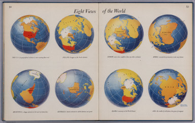
Harrison, Richard Edes
Full Title
(Covers to) Look At The World: The Fortune Atlas For world Strategy. By Richard Edes Harrison. Text by Editor of Fortune. New York: Alfred A. Knopf 1944. (on verso) Copyright 1944 by Time Incorporated. Atlas exhibiting large scale maps, drawn from the point of view of the air age. Dust Cover showing a relief map of japan in full color. (on verso of dust cover) Text containing a short description of the atlas, biography and picture of Richard. E. Harrison. Atlas, Contains full color, and black and white maps and plans. Drawn By Richard Edes Harrison. With Geographical, Statistical, And Historical Descriptions.
List No
1970.001
Note
Richard Harrison produced a unique view of the world for the "air age." These maps are precursors of our ubiquitous satellite maps of today, yet hand drawn with great cartographic skill. The atlas contains 66, (2) page text, index, statistics, and color, and black and white maps (some folded) and plans. Dust Covers are dark blue heavy paper printed with relief map of japan. Covers are teal blue with the title "Look at the world : the Fortune Atlas For world Strategy. By Richard Edes Harrison. Text by Editor of Fortune. New York: Alfred A. Knopf." in center.
Author
Harrison, Richard Edes
Full Title
(Text Page to) Look At The World: The Fortune Atlas For world Strategy. By Richard Edes Harrison. Text by Editor of Fortune. New York: Alfred A. Knopf 1944. (on verso) Copyright 1944 by Time Incorporated. Atlas exhibiting large scale maps, drawn from the point of view of the air age. Dust Cover showing a relief map of japan in full color. (on verso of dust cover) Text containing a short description of the atlas, biography and picture of Richard. E. Harrison. Atlas, Contains full color, and black and white maps and plans. Drawn By Richard Edes Harrison. With Geographical, Statistical, And Historical Descriptions.
List No
1970.002
Note
On verso of dust cover, text, photograph and Note: "The Jacket map appeared in the April 1944 issue of Fortune ..." Atlas contains 66, (2) page text, index, statistics, color, and black and white maps (some folded) and plans. Covers are teal blue with the title "Look at the world: the Fortune Atlas For world Strategy. By Richard Edes Harrison. Text by Editor of Fortune. New York: Alfred A. Knopf." in center.
Author
Harrison, Richard Edes
Full Title
(Covers to) Look At The World: The Fortune Atlas For world Strategy. By Richard Edes Harrison. Text by Editor of Fortune. New York: Alfred A. Knopf 1944. (on verso) Copyright 1944 by Time Incorporated. Atlas exhibiting large scale maps, drawn from the point of view of the air age. Dust Cover showing a relief map of japan in full color. (on verso of dust cover) Text containing a short description of the atlas, biography and picture of Richard. E. Harrison. Atlas, Contains full color, and black and white maps and plans. Drawn By Richard Edes Harrison. With Geographical, Statistical, And Historical Descriptions.
List No
1970.003
Note
Atlas contains 66, (2) page text, index, statistics, color, and black and white maps (some folded) and plans. Dust Covers are dark blue heavy paper printed with shaded relief map of Japan. Covers are teal blue with the title "Look at the world: the Fortune Atlas For world Strategy. By Richard Edes Harrison. Text by Editor of Fortune. New York: Alfred A. Knopf." in center.
Author
Harrison, Richard Edes
Full Title
(Title Page to) Look At The World: The Fortune Atlas For world Strategy. By Richard Edes Harrison. Text by Editor of Fortune. New York: Alfred A. Knopf 1944. (on verso) Copyright 1944 by Time Incorporated. Atlas exhibiting large scale maps, drawn from the point of view of the air age. Dust Cover showing a relief map of japan in full color. (on verso of dust cover) Text containing a short description of the atlas, biography and picture of Richard. E. Harrison. Atlas, Contains full color, and black and white maps and plans. Drawn By Richard Edes Harrison. With Geographical, Statistical, And Historical Descriptions.
List No
1970.004
Note
Atlas contains 66, (2) page text, index, statistics, color, and black and white maps (some folded) and plans. Dust Covers are dark blue heavy paper printed with relief shaded map of Japan. Covers are teal blue with the title "Look at the world: the Fortune Atlas For world Strategy. By Richard Edes Harrison. Text by Editor of Fortune. New York: Alfred A. Knopf." in center.
Author
Harrison, Richard Edes
Full Title
(Title Page to) Look At The World: The Fortune Atlas For world Strategy. By Richard Edes Harrison. Text by Editor of Fortune. New York: Alfred A. Knopf 1944. (on verso) Copyright 1944 by Time Incorporated. Atlas exhibiting large scale maps, drawn from the point of view of the air age. Dust Cover showing a relief map of japan in full color. (on verso of dust cover) Text containing a short description of the atlas, biography and picture of Richard. E. Harrison. Atlas, Contains full color, and black and white maps and plans. Drawn By Richard Edes Harrison. With Geographical, Statistical, And Historical Descriptions.
List No
1970.005
Note
Atlas contains 66, (2) page text, index, statistics, color, and black and white maps (some folded) and plans. Dust Covers are dark blue heavy paper printed with shaded relief map of Japan. Covers are teal blue with the title "Look at the world: the Fortune Atlas For world Strategy. By Richard Edes Harrison. Text by Editor of Fortune. New York: Alfred A. Knopf." in center.
Author
Harrison, Richard Edes
Full Title
(Text Page to) Look At The World: The Fortune Atlas For world Strategy. By Richard Edes Harrison. Text by Editor of Fortune. New York: Alfred A. Knopf 1944. (on verso) Copyright 1944 by Time Incorporated. Atlas exhibiting large scale maps, drawn from the point of view of the air age. Dust Cover showing a relief map of japan in full color. (on verso of dust cover) Text containing a short description of the atlas, biography and picture of Richard. E. Harrison. Atlas, Contains full color, and black and white maps and plans. Drawn By Richard Edes Harrison. With Geographical, Statistical, And Historical Descriptions.
List No
1970.006
Note
Text includes copyright statement. "The Original copyrights of maps previously published in Fortune were issued to Time Inc... " Atlas contains 66, (2) page text, index, statistics, color, and black and white maps (some folded) and plans. Dust Covers are dark blue heavy paper printed with shaded relief map of Japan. Covers are teal blue with the title "Look at the world: the Fortune Atlas For world Strategy. By Richard Edes Harrison. Text by Editor of Fortune. New York: Alfred A. Knopf." in center.
Author
Harrison, Richard Edes
Full Title
(Contents to) Look At The World: The Fortune Atlas For world Strategy. By Richard Edes Harrison. Text by Editor of Fortune. New York: Alfred A. Knopf 1944. (on verso) Copyright 1944 by Time Incorporated. Atlas exhibiting large scale maps, drawn from the point of view of the air age. Dust Cover showing a relief map of japan in full color. (on verso of dust cover) Text containing a short description of the atlas, biography and picture of Richard. E. Harrison. Atlas, Contains full color, and black and white maps and plans. Drawn By Richard Edes Harrison. With Geographical, Statistical, And Historical Descriptions.
List No
1970.007
Note
Atlas contains 66, (2) page text, index, statistics, color, and black and white maps (some folded) and plans. Dust Covers are dark blue heavy paper printed with shaded relief map of Japan. Covers are teal blue with the title "Look at the world: the Fortune Atlas For world Strategy. By Richard Edes Harrison. Text by Editor of Fortune. New York: Alfred A. Knopf." in center.
Author
Harrison, Richard Edes
Full Title
(Text Page to) Look At The World: The Fortune Atlas For world Strategy. By Richard Edes Harrison. Text by Editor of Fortune. New York: Alfred A. Knopf 1944. (on verso) Copyright 1944 by Time Incorporated. Atlas exhibiting large scale maps, drawn from the point of view of the air age. Dust Cover showing a relief map of japan in full color. (on verso of dust cover) Text containing a short description of the atlas, biography and picture of Richard. E. Harrison. Atlas, Contains full color, and black and white maps and plans. Drawn By Richard Edes Harrison. With Geographical, Statistical, And Historical Descriptions.
List No
1970.008
Note
Acknowledgments of staff, advisors, and contributors. Atlas contains 66, (2) page text, index, statistics, color, and black and white maps (some folded) and plans. Dust Covers are dark blue heavy paper printed with shaded relief map of Japan. Covers are teal blue with the title "Look at the world: the Fortune Atlas For world Strategy. By Richard Edes Harrison. Text by Editor of Fortune. New York: Alfred A. Knopf." in center.
Author
Harrison, Richard Edes
Full Title
(Preface to) Look At The World: The Fortune Atlas For world Strategy. By Richard Edes Harrison. Text by Editor of Fortune. New York: Alfred A. Knopf 1944. (on verso) Copyright 1944 by Time Incorporated. Atlas exhibiting large scale maps, drawn from the point of view of the air age. Dust Cover showing a relief map of japan in full color. (on verso of dust cover) Text containing a short description of the atlas, biography and picture of Richard. E. Harrison. Atlas, Contains full color, and black and white maps and plans. Drawn By Richard Edes Harrison. With Geographical, Statistical, And Historical Descriptions.
List No
1970.009
Note
Preface written by the Editors of Fortune. Atlas contains 66, (2) page text, index, statistics, color, and black and white maps (some folded) and plans. Dust Covers are dark blue heavy paper printed with shaded relief map of Japan. Covers are teal blue with the title "Look at the world: the Fortune Atlas For world Strategy. By Richard Edes Harrison. Text by Editor of Fortune. New York: Alfred A. Knopf." in center.
Author
Harrison, Richard Edes
Full Title
One World, One War. (inset) Complete Azimuthal Equidistant Projections. (inset) Note of the Projections. And a colored reference to The Line up, Oct. 15, 1943. (to accompany) Look At The World: The Fortune Atlas For world Strategy. By Richard Edes Harrison. Text by Editor of Fortune. New York: Alfred A. Knopf 1944. (on verso) Copyright 1944 by Time Incorporated.
List No
1970.010
Note
Full color map. Includes text. Atlas contains 66, (2) page text, index, statistics, color, and black and white maps (some folded) and plans. Covers are teal blue with the title "Look at the world: the Fortune Atlas For world Strategy. By Richard Edes Harrison. Text by Editor of Fortune. New York: Alfred A. Knopf." in center.
Author
Harrison, Richard Edes
Full Title
(Text Page to) The Geographical Sense. (to accompany) Look At The World: The Fortune Atlas For world Strategy. By Richard Edes Harrison. Text by Editor of Fortune. New York: Alfred A. Knopf 1944. (on verso) Copyright 1944 by Time Incorporated.
List No
1970.011
Note
Study of Geography. Atlas contains 66, (2) page text, index, statistics, color, and black and white maps (some folded) and plans. Covers are teal blue with the title "Look at the world: the Fortune Atlas For world Strategy. By Richard Edes Harrison. Text by Editor of Fortune. New York: Alfred A. Knopf." in center.
Author
Harrison, Richard Edes
Full Title
(Text Page to) The Geographical Sense. (to accompany) Look At The World: The Fortune Atlas For world Strategy. By Richard Edes Harrison. Text by Editor of Fortune. New York: Alfred A. Knopf 1944. (on verso) Copyright 1944 by Time Incorporated.
List No
1970.012
Note
Reminder of the Geographical Sense. Study of Geography. Atlas contains 66, (2) page text, index, statistics, color, and black and white maps (some folded) and plans. Covers are teal blue with the title "Look at the world: the Fortune Atlas For world Strategy. By Richard Edes Harrison. Text by Editor of Fortune. New York: Alfred A. Knopf." in center.
Author
Harrison, Richard Edes
Full Title
Outward From The U.S. (to accompany) Look At The World: The Fortune Atlas For world Strategy. By Richard Edes Harrison. Text by Editor of Fortune. New York: Alfred A. Knopf 1944. (on verso) Copyright 1944 by Time Incorporated.
List No
1970.013
Note
Full color view of the globe. Includes text. Atlas contains 66, (2) page text, index, statistics, color, and black and white maps (some folded) and plans. Covers are teal blue with the title "Look at the world: the Fortune Atlas For world Strategy. By Richard Edes Harrison. Text by Editor of Fortune. New York: Alfred A. Knopf." in center.
Author
Harrison, Richard Edes
Full Title
Northeast To Europe. (drawn by) Richard Edes Harrison 1940. (to accompany) Look At The World: The Fortune Atlas For world Strategy. By Richard Edes Harrison. Text by Editor of Fortune. New York: Alfred A. Knopf 1944. (on verso) Copyright 1944 by Time Incorporated.
List No
1970.014
Note
Uncolored map. Includes location map, text, and note on Scale. Relief shown by shadings. Atlas contains 66, (2) page text, index, statistics, color, and black and white maps (some folded) and plans. Covers are teal blue with the title "Look at the world: the Fortune Atlas For world Strategy. By Richard Edes Harrison. Text by Editor of Fortune. New York: Alfred A. Knopf." in center.
Author
Harrison, Richard Edes
Full Title
Northwest To Asia. (to accompany) Look At The World: The Fortune Atlas For world Strategy. By Richard Edes Harrison. Text by Editor of Fortune. New York: Alfred A. Knopf 1944. (on verso) Copyright 1944 by Time Incorporated.
List No
1970.015
Note
Uncolored map. Includes location map, and text. Relief shown by shadings. Atlas contains 66, (2) page text, index, statistics, color, and black and white maps (some folded) and plans. Covers are teal blue with the title "Look at the world: the Fortune Atlas For world Strategy. By Richard Edes Harrison. Text by Editor of Fortune. New York: Alfred A. Knopf." in center.
Author
Harrison, Richard Edes
Full Title
Southeast to Latin America. (drawn by) Richard Edes Harrison. (to accompany) Look At The World: The Fortune Atlas For world Strategy. By Richard Edes Harrison. Text by Editor of Fortune. New York: Alfred A. Knopf 1944. (on verso) Copyright 1944 by Time Incorporated.
List No
1970.016
Note
Uncolored map. Includes location map, and text. Relief shown by shadings. Atlas contains 66, (2) page text, index, statistics, color, and black and white maps (some folded) and plans. Covers are teal blue with the title "Look at the world: the Fortune Atlas For world Strategy. By Richard Edes Harrison. Text by Editor of Fortune. New York: Alfred A. Knopf." in center.
Author
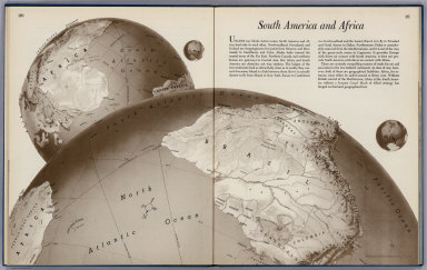
Harrison, Richard Edes
Full Title
South America To Africa. (drawn by) Richard Edes Harrison 1940. (to accompany) Look At The World: The Fortune Atlas For world Strategy. By Richard Edes Harrison. Text by Editor of Fortune. New York: Alfred A. Knopf 1944. (on verso) Copyright 1944 by Time Incorporated.
List No
1970.017
Note
Uncolored map. Includes location map, and text. Relief shown by shadings. Atlas contains 66, (2) page text, index, statistics, color, and black and white maps (some folded) and plans. Covers are teal blue with the title "Look at the world: the Fortune Atlas For world Strategy. By Richard Edes Harrison. Text by Editor of Fortune. New York: Alfred A. Knopf." in center.
Author
Harrison, Richard Edes
Full Title
The U.S. From The Outside. (to accompany) Look At The World: The Fortune Atlas For world Strategy. By Richard Edes Harrison. Text by Editor of Fortune. New York: Alfred A. Knopf 1944. (on verso) Copyright 1944 by Time Incorporated.
List No
1970.018
Note
Uncolored map. Includes text. Relief shown by shadings. Atlas contains 66, (2) page text, index, statistics, color, and black and white maps (some folded) and plans. Covers are teal blue with the title "Look at the world: the Fortune Atlas For world Strategy. By Richard Edes Harrison. Text by Editor of Fortune. New York: Alfred A. Knopf." in center.
Author
Harrison, Richard Edes
Full Title
Atlantic Arena. Orthographic Projection. (to accompany) Look At The World: The Fortune Atlas For world Strategy. By Richard Edes Harrison. Text by Editor of Fortune. New York: Alfred A. Knopf 1944. (on verso) Copyright 1944 by Time Incorporated.
List No
1970.019
Note
Full color map. Includes text, insets of the World and The Other Half. Atlas contains 66, (2) page text, index, statistics, color, and black and white maps (some folded) and plans. Covers are teal blue with the title "Look at the world: the Fortune Atlas For world Strategy. By Richard Edes Harrison. Text by Editor of Fortune. New York: Alfred A. Knopf." in center.
Author
Harrison, Richard Edes
Full Title
Europe From the Northwest. (drawn by) Richard Edes Harrison 1940. (to accompany) Look At The World: The Fortune Atlas For world Strategy. By Richard Edes Harrison. Text by Editor of Fortune. New York: Alfred A. Knopf 1944. (on verso) Copyright 1944 by Time Incorporated.
List No
1970.020
Note
Uncolored map. Includes text, and location map. Relief shown by shadings. Atlas contains 66, (2) page text, index, statistics, color, and black and white maps (some folded) and plans. Covers are teal blue with the title "Look at the world: the Fortune Atlas For world Strategy. By Richard Edes Harrison. Text by Editor of Fortune. New York: Alfred A. Knopf." in center.
Author
Harrison, Richard Edes
Full Title
Europe From the Southwest. Drawn by Richard Edes Harrison. (copyright) 1943 Time, Inc.(to accompany) Look At The World: The Fortune Atlas For world Strategy. By Richard Edes Harrison. Text by Editor of Fortune. New York: Alfred A. Knopf 1944. (on verso) Copyright 1944 by Time Incorporated.
List No
1970.021
Note
Full color shaded relief map. Includes text, and location map. Atlas contains 66, (2) page text, index, statistics, color, and black and white maps (some folded) and plans. Covers are teal blue with the title "Look at the world: the Fortune Atlas For world Strategy. By Richard Edes Harrison. Text by Editor of Fortune. New York: Alfred A. Knopf." in center.
Author
Harrison, Richard Edes
Full Title
Europe From the East. (drawn by) Richard Edes Harrison. 1943. (to accompany) Look At The World: The Fortune Atlas For world Strategy. By Richard Edes Harrison. Text by Editor of Fortune. New York: Alfred A. Knopf 1944. (on verso) Copyright 1944 by Time Incorporated.
List No
1970.022
Note
Full color shaded relief map. Includes text, and location map. Atlas contains 66, (2) page text, index, statistics, color, and black and white maps (some folded) and plans. Covers are teal blue with the title "Look at the world: the Fortune Atlas For world Strategy. By Richard Edes Harrison. Text by Editor of Fortune. New York: Alfred A. Knopf." in center.
Author
Harrison, Richard Edes
Full Title
World Island. Orthographic Projection. (to accompany) Look At The World: The Fortune Atlas For world Strategy. By Richard Edes Harrison. Text by Editor of Fortune. New York: Alfred A. Knopf 1944. (on verso) Copyright 1944 by Time Incorporated.
List No
1970.023
Note
Full color map. Includes text, insets of The other half and the world. Atlas contains 66, (2) page text, index, statistics, color, and black and white maps (some folded) and plans. Covers are teal blue with the title "Look at the world: the Fortune Atlas For world Strategy. By Richard Edes Harrison. Text by Editor of Fortune. New York: Alfred A. Knopf." in center.
Author
Harrison, Richard Edes
Full Title
Southeast To Asia. (drawn by) Richard Edes Harrison. 1942. (to accompany) Look At The World: The Fortune Atlas For world Strategy. By Richard Edes Harrison. Text by Editor of Fortune. New York: Alfred A. Knopf 1944. (on verso) Copyright 1944 by Time Incorporated.
List No
1970.024
Note
Full color shaded relief map. Includes text, inset and location map. Atlas contains 66, (2) page text, index, statistics, color, and black and white maps (some folded) and plans. Covers are teal blue with the title "Look at the world: the Fortune Atlas For world Strategy. By Richard Edes Harrison. Text by Editor of Fortune. New York: Alfred A. Knopf." in center.
Author
Harrison, Richard Edes
Full Title
Russia From The South. (drawn by) Richard Edes Harrison. 1941. (to accompany) Look At The World: The Fortune Atlas For world Strategy. By Richard Edes Harrison. Text by Editor of Fortune. New York: Alfred A. Knopf 1944. (on verso) Copyright 1944 by Time Incorporated.
List No
1970.025
Note
Full color shaded relief map. Includes text, inset maps showing the population density, and Topography. References to Transportation, Cities and Distances. Atlas contains 66, (2) page text, index, statistics, color, and black and white maps (some folded) and plans. Covers are teal blue with the title "Look at the world: the Fortune Atlas For world Strategy. By Richard Edes Harrison. Text by Editor of Fortune. New York: Alfred A. Knopf." in center.
Author
Harrison, Richard Edes
Full Title
China From the East. (drawn by) Richard Edes Harrison. 1941. (to accompany) Look At The World: The Fortune Atlas For world Strategy. By Richard Edes Harrison. Text by Editor of Fortune. New York: Alfred A. Knopf 1944. (on verso) Copyright 1944 by Time Incorporated.
List No
1970.026
Note
Full color shaded relief map. Includes text, inset maps showing Migration of Chinese universities, and Key to minerals. Atlas contains 66, (2) page text, index, statistics, color, and black and white maps (some folded) and plans. Covers are teal blue with the title "Look at the world: the Fortune Atlas For world Strategy. By Richard Edes Harrison. Text by Editor of Fortune. New York: Alfred A. Knopf." in center.
Author
Harrison, Richard Edes
Full Title
Pacific Arena. Orthographic Projection. (to accompany) Look At The World: The Fortune Atlas For world Strategy. By Richard Edes Harrison. Text by Editor of Fortune. New York: Alfred A. Knopf 1944. (on verso) Copyright 1944 by Time Incorporated.
List No
1970.027
Note
Full color map. Includes text, inset maps showing the other half and the world. Atlas contains 66, (2) page text, index, statistics, color, and black and white maps (some folded) and plans. Covers are teal blue with the title "Look at the world: the Fortune Atlas For world Strategy. By Richard Edes Harrison. Text by Editor of Fortune. New York: Alfred A. Knopf." in center.
Author
Harrison, Richard Edes
Full Title
Japan To Alaska. (drawn by) Richard Edes Harrison 1943. Copyright 1943. Time Inc. (to accompany) Look At The World: The Fortune Atlas For world Strategy. By Richard Edes Harrison. Text by Editor of Fortune. New York: Alfred A. Knopf 1944. (on verso) Copyright 1944 by Time Incorporated.
List No
1970.028
Note
Full color shaded relief map. Includes text, and location map. Atlas contains 66, (2) page text, index, statistics, color, and black and white maps (some folded) and plans. Covers are teal blue with the title "Look at the world: the Fortune Atlas For world Strategy. By Richard Edes Harrison. Text by Editor of Fortune. New York: Alfred A. Knopf." in center.
Author
Harrison, Richard Edes
Full Title
Japan From The Solomons. (drawn by) Richard Edes Harrison 1943. Copyright 1943. Time Inc. (to accompany) Look At The World: The Fortune Atlas For world Strategy. By Richard Edes Harrison. Text by Editor of Fortune. New York: Alfred A. Knopf 1944. (on verso) Copyright 1944 by Time Incorporated.
List No
1970.029
Note
Full color shaded relief map. Includes relief map of Solomon Islands, New Guinea Caroline Islands ... , text, and location map. Atlas contains 66, (2) page text, index, statistics, color, and black and white maps (some folded) and plans. Covers are teal blue with the title "Look at the world: the Fortune Atlas For world Strategy. By Richard Edes Harrison. Text by Editor of Fortune. New York: Alfred A. Knopf." in center.
Author
Harrison, Richard Edes
Full Title
Japan From China. (drawn by) Richard Edes Harrison 1943. Copyright 1943. Time Inc. (to accompany) Look At The World: The Fortune Atlas For world Strategy. By Richard Edes Harrison. Text by Editor of Fortune. New York: Alfred A. Knopf 1944. (on verso) Copyright 1944 by Time Incorporated.
List No
1970.030
Note
Full color shaded relief map. Includes location map. Atlas contains 66, (2) page text, index, statistics, color, and black and white maps (some folded) and plans. Covers are teal blue with the title "Look at the world: the Fortune Atlas For world Strategy. By Richard Edes Harrison. Text by Editor of Fortune. New York: Alfred A. Knopf." in center.
Author
Harrison, Richard Edes
Full Title
Japan From Siberia. (drawn by) Richard Edes Harrison 1943. (to accompany) Look At The World: The Fortune Atlas For world Strategy. By Richard Edes Harrison. Text by Editor of Fortune. New York: Alfred A. Knopf 1944. (on verso) Copyright 1944 by Time Incorporated.
List No
1970.031
Note
Full color shaded relief map. Includes relief map of Siberia, Manchuria ... and location map. Atlas contains 66, (2) page text, index, statistics, color, and black and white maps (some folded) and plans. Covers are teal blue with the title "Look at the world: the Fortune Atlas For world Strategy. By Richard Edes Harrison. Text by Editor of Fortune. New York: Alfred A. Knopf." in center.
Author
Harrison, Richard Edes
Full Title
Arctic Arena. Orthographic Projection. (to accompany) Look At The World: The Fortune Atlas For world Strategy. By Richard Edes Harrison. Text by Editor of Fortune. New York: Alfred A. Knopf 1944. (on verso) Copyright 1944 by Time Incorporated.
List No
1970.032
Note
Full color map. Includes text, legend and inset map of "The other half" of the globe showing Antarctica. Atlas contains 66, (2) page text, index, statistics, color, and black and white maps (some folded) and plans. Covers are teal blue with the title "Look at the world: the Fortune Atlas For world Strategy. By Richard Edes Harrison. Text by Editor of Fortune. New York: Alfred A. Knopf." in center.
Author
Harrison, Richard Edes
Full Title
Eight Views Of The World. (by) Richard Edes Harrison 1943. Exhibiting the location of The U.S. Islands. Europe. Africa. Argentina. Australia. Alaska. And Asia. (to accompany) Look At The World: The Fortune Atlas For world Strategy. By Richard Edes Harrison. Text by Editor of Fortune. New York: Alfred A. Knopf 1944. (on verso) Copyright 1944 by Time Incorporated.
List No
1970.033
Note
Full color maps. Atlas contains 66, (2) page text, index, statistics, color, and black and white maps (some folded) and plans. Covers are teal blue with the title "Look at the world: the Fortune Atlas For world Strategy. By Richard Edes Harrison. Text by Editor of Fortune. New York: Alfred A. Knopf." in center.
Author
Harrison, Richard Edes
Full Title
Great Circle Airways. Natural scale at point of tangency 1:81,000,000. North Polar Gnomonic Projection. (inset) North Polar Azmuthal Equidistant Projection. (inset) South Polar Genomonic Chart. (to accompany) Look At The World: The Fortune Atlas For world Strategy. By Richard Edes Harrison. Text by Editor of Fortune. New York: Alfred A. Knopf 1944. (on verso) Copyright 1944 by Time Incorporated.
List No
1970.034
Note
Full color map. Includes text. Atlas contains 66, (2) page text, index, statistics, color, and black and white maps (some folded) and plans. Covers are teal blue with the title "Look at the world: the Fortune Atlas For world Strategy. By Richard Edes Harrison. Text by Editor of Fortune. New York: Alfred A. Knopf." in center.
Author
Harrison, Richard Edes
Full Title
(Index Page to) Abbreviations Used in the Index. (to accompany) Look At The World: The Fortune Atlas For world Strategy. By Richard Edes Harrison. Text by Editor of Fortune. New York: Alfred A. Knopf 1944. (on verso) Copyright 1944 by Time Incorporated.
List No
1970.035
Note
A list of abbreviations used in the index. Atlas contains 66, (2) page text, index, statistics, color, and black and white maps (some folded) and plans. Covers are teal blue with the title "Look at the world: the Fortune Atlas For world Strategy. By Richard Edes Harrison. Text by Editor of Fortune. New York: Alfred A. Knopf." in center.
Author
Harrison, Richard Edes
Full Title
(Index to) List of Maps. Look At The World: The Fortune Atlas For world Strategy. By Richard Edes Harrison. Text by Editor of Fortune. New York: Alfred A. Knopf 1944. (on verso) Copyright 1944 by Time Incorporated.
List No
1970.036
Note
Atlas contains 66, (2) page text, index, statistics, color, and black and white maps (some folded) and plans. Covers are teal blue with the title "Look at the world: the Fortune Atlas For world Strategy. By Richard Edes Harrison. Text by Editor of Fortune. New York: Alfred A. Knopf." in center.
Author
Harrison, Richard Edes
Full Title
(Index to) List of Maps (continued). Look At The World: The Fortune Atlas For world Strategy. By Richard Edes Harrison. Text by Editor of Fortune. New York: Alfred A. Knopf 1944. (on verso) Copyright 1944 by Time Incorporated.
List No
1970.037
Note
Atlas contains 66, (2) page text, index, statistics, color, and black and white maps (some folded) and plans. Covers are teal blue with the title "Look at the world: the Fortune Atlas For world Strategy. By Richard Edes Harrison. Text by Editor of Fortune. New York: Alfred A. Knopf." in center.
Author
Harrison, Richard Edes
Full Title
(Index to) List of Maps (continued). Look At The World: The Fortune Atlas For world Strategy. By Richard Edes Harrison. Text by Editor of Fortune. New York: Alfred A. Knopf 1944. (on verso) Copyright 1944 by Time Incorporated.
List No
1970.038
Note
Atlas contains 66, (2) page text, index, statistics, color, and black and white maps (some folded) and plans. Covers are teal blue with the title "Look at the world: the Fortune Atlas For world Strategy. By Richard Edes Harrison. Text by Editor of Fortune. New York: Alfred A. Knopf." in center.
Author
Harrison, Richard Edes
Full Title
(Index to) List of Maps (continued). Look At The World: The Fortune Atlas For world Strategy. By Richard Edes Harrison. Text by Editor of Fortune. New York: Alfred A. Knopf 1944. (on verso) Copyright 1944 by Time Incorporated.
List No
1970.039
Note
Atlas contains 66, (2) page text, index, statistics, color, and black and white maps (some folded) and plans. Covers are teal blue with the title "Look at the world: the Fortune Atlas For world Strategy. By Richard Edes Harrison. Text by Editor of Fortune. New York: Alfred A. Knopf." in center.
Author
Harrison, Richard Edes
Full Title
(Index to) List of Maps (continued). Look At The World: The Fortune Atlas For world Strategy. By Richard Edes Harrison. Text by Editor of Fortune. New York: Alfred A. Knopf 1944. (on verso) Copyright 1944 by Time Incorporated.
List No
1970.040
Note
Atlas contains 66, (2) page text, index, statistics, color, and black and white maps (some folded) and plans. Covers are teal blue with the title "Look at the world: the Fortune Atlas For world Strategy. By Richard Edes Harrison. Text by Editor of Fortune. New York: Alfred A. Knopf." in center.
Author
Harrison, Richard Edes
Full Title
(Index to) List of Maps (continued). Look At The World: The Fortune Atlas For world Strategy. By Richard Edes Harrison. Text by Editor of Fortune. New York: Alfred A. Knopf 1944. (on verso) Copyright 1944 by Time Incorporated.
List No
1970.041
Note
Atlas contains 66, (2) page text, index, statistics, color, and black and white maps (some folded) and plans. Covers are teal blue with the title "Look at the world: the Fortune Atlas For world Strategy. By Richard Edes Harrison. Text by Editor of Fortune. New York: Alfred A. Knopf." in center.
Author
Harrison, Richard Edes
Full Title
(Text Page to) Look At The World: The Fortune Atlas For world Strategy. By Richard Edes Harrison. Text by Editor of Fortune. New York: Alfred A. Knopf 1944. (on verso) Copyright 1944 by Time Incorporated.
List No
1970.042
Note
Atlas contains 66, (2) page text, index, statistics, color, and black and white maps (some folded) and plans. Atlas Printed by Duenewald Printing Corp. of New York. Type set by Composing Room Inc. Bound by H. Wolff, New York. Typography by H. Hendrickson. Binding by Warren Chappell.Covers are teal blue with the title "Look at the world: the Fortune Atlas For world Strategy. By Richard Edes Harrison. Text by Editor of Fortune. New York: Alfred A. Knopf." in center.
Author
[Harrison, Richard Edes, Army Information Branch, Army Service Forces]
Full Title
Newsmap. (War front near Florence, Italy. Guam, Agiguwant, Tinian and Saipan. Pacific Island Groups). Monday, July 31, 1944. ... Vol. III No. 15F. Prepared and Distributed by the Army Information Branch, Army Service Forces. Navy Distribution by Educational Services Section, BuPers, Navy Dept., Washington D.C. U.S. Government Printing Office: 1944 - 591000.
List No
6767.002
Note
Three maps, four photographs and summary text on five war fronts.
Author
Rand McNally & Co.
Full Title
Rand McNally Map of United States Military Posts.
List No
6783.003
Author
[Utley, Clifton, Skelly Oil Company]
Full Title
Clifton Utley's war map of the world : Complements of your neighborhood Skellyman. (on verso) Clifton Utley's war map of the Pacific and far East. (with) Clifton Utley's war map of the Mediterranean area. Skelly.
List No
8236.001
Note
Date estimated. Three color maps on one sheet, 40.5x60.5, both sides. Shows territorial divisions, military bases, air mileage, aid routes, and time zones. Includes text, population, distances, and radio listings for Clifton Utley's news broadcasts.
Author
[Utley, Clifton, Skelly Oil Company]
Full Title
Clifton Utley's war map of the Pacific and far East. (with) Clifton Utley's war map of the Mediterranean area. (on verso) Clifton Utley's war map of the world : Complements of your neighborhood Skellyman. Skelly.
List No
8236.002
Note
Date estimated. Three color maps on one sheet, 40.5x60.5, both sides. Shows territorial divisions, military bases, air mileage, aid routes, and time zones. Includes text, population, distances, and radio listings for Clifton Utley's news broadcasts.
Author
[Turner, Stanley, Petersen, C.C.]
Full Title
Dated events, World War map by Stanley Turner. Dated events, World War map, by Stanley Turner A.R.C.A. Allyn and Bacon : Publishers of the Stull - Hatch Global Geographies. (On verso: War map of Pacific Ocean area). (insets) Western hemisphere. (with) Part of the Eastern hemisphere. (with) Africa.
List No
8237.001
Note
In full color. Legend includes naval bases; cities blitzed by Nazis Luftwaffe; industries bombed by R.A.F; countries under British control; countries conquered by the Nazis; neutral countries. Includes Relief shown pictorially. On verso untitled black and white map of Pacific naval operations (scale ca. 1:34,000,000). Maps Include text, historical and chronological notes pertaining to World War II. Shows cities, industry, agriculture, forests, etc.
Author
[Turner, Stanley, Petersen, C.C.]
Full Title
(War map of Pacific Ocean area). Allyn and Bacon : Publishers of the Stull - Hatch Global Geographies. (on verso) Dated events, World War map by Stanley Turner. Dated events, World War map, by Stanley Turner A.R.C.A. Allyn and Bacon : Publishers of the Stull - Hatch Global Geographies. (insets) Western hemisphere. (with) Part of the Eastern hemisphere. (with) Africa.
List No
8237.002
Note
untitled black and white map of Pacific naval operations (scale ca. 1:34,000,000). Maps Include naval bases: British, U.S.A., Russian, Jap., text, historical and chronological notes pertaining to World War II. Shows cities, industry, agriculture, forests, etc.
Author
[Turner, Stanley Francis, Petersen, C.C.]
Full Title
Canada at war. Published with the compliments of Thomas J. Lipton Limited. Stanley Turner. Copyright. Canada and U.S.A. 1944, C.C. Petersen, Publishing and Advertising, Toronto, ONT. (inset) Canada's war development.
List No
8258.000
Note
Pictorial map of Canada, a promotional poster produced for Lipton's Tea, with drawings of Lipton products in the four corners. Shows provinces, rivers, towns, landmarks, buildings, people, Naval stations, military districts, military training camp, airplane manufacturing, Alaska Highway, etc. Includes legend, notes, airplanes in flight, ships in the oceans, and icebergs in the Arctic Ocean and Baffin Bay, and portions of the neighboring United States and Greenland. The cartouche shows the Canadian seal and a mileage scale.
Author
[White, Harry D., United States. Army. Infantry Division, 79th.]
Full Title
Through France with the 79th Infantry Division, 14 June to 29 Aug, 1944. Maj. Gen. I.T. Wyche, Commanding. Steve Kalihan; Harry D White. printed by Fritz Busche Druckereiges,M.B.H., Dortmund (Germany).
List No
8344.000
Note
Color pictorial map. Author names from signatures reproduced in cursive script inside lower right corner. Shows towns, river, forests, along the route of the U.S. Army 79th Infantry Division as it moved from a 14 June 1944 landing on the Normandy shore near St. Mere Eglise. Inotes: "On 2130 on the darkest, rainiest Aug 19 on record." Borders with large letters: Camp Pickett, Camp Blanding Tennessee, Camp Forrest, California, Arizona Desert, Camp Phillips, Poe, England, Sainte Mere Eglise, Valognes, Cherbourg, La Haye Du Putts, Lessay, Avranches, Fougeres, Laal, Le Mans, La Mesle sur Sarthe, Nogent Le Roi, Mantes Gassicourt, Seine. Includes color vignettes showing troops and landing craft.
Author
[White, Harry D., United States. Army. Infantry Division, 79th.]
Full Title
To Belgium and back with the 79th Infantry Division, 31 Aug to 25 Oct, 1944. Maj. Gen. I.T. Wyche, Commanding. Steve Kalihan; Harry D White. Printed by Fritz Busche Druckereiges, M.B.H., Dortmund (Germany).
List No
8347.000
Note
Color pictorial map. Author names from signatures reproduced in cursive script inside lower right corner. Shows towns, river, forests, along the route of the U.S. Army advancing toward Belgium Borders with large letters: Seine Bridgehead, Drocourt, St Just, Montdidier, Clery, St Amand, Belgium, Valenciennes, Cambrai, Soissons, Reims, Jonville, Neufchateau, Mirecourt, charmes, Bayon, St Germain, Gerberviller, Frambois, Luneville, Croismat, Parroy, Embermen. Includes notes and color vignettes showing Reims cathedral, American troops, and German soldiers .
Author
Turner, Stanley
Full Title
Dated Events War Map. 16th Edition.
List No
8713.001
Note
Date estimated to be early months of 1944.
Author
Turner, Stanley
Full Title
Dated Events War Map. 1944. 19th Edition.
List No
8713.002
Note
Invasion Map of Fortress Europe, Commemorating D-Day, June 6, 1944.
Author
[Turner, Stanley, Petersen, C.C.]
Full Title
Dated Events War Map. 1945. 18th Edition.
List No
8713.007
Author
[Turner, Stanley, Petersen, C.C.]
Full Title
Covers to - Envelope) Dated Events War Map. 1945. 18th Edition.
List No
8713.008
Author
Pearson, Charles
Full Title
Yank's New Guinea.
List No
8897.000
Note
Date estimated.
Author
C.P.D.
Full Title
Pacific Battlefront. (inset) Kawajalien Atoll.
List No
8915.000
Note
Date from Indian postmark on back.
Author
George Philip & Son, Ltd.
Full Title
(Covers to) Daily Express War Map Sheet I, Western Zone. A Daily Express Production.
List No
9124.001
Note
Cover printed on back of a map panel.
Author
George Philip & Son, Ltd.
Full Title
Daily Express War Map, Western Zone. (inset) Norway and Sweden.
List No
9124.002
Note
Includes portraits of Allied commanders. Some black arrows, representing advances of U.S. forces, added after initial printing.
Author
Rojankovsky, F.
Full Title
Help Produce with War Bonds.
List No
9781.002
Author
Turner, Stanley
Full Title
Dated Events World War Map. (insets) Western Hemisphere. Part of the Eastern Hemisphere.
List No
9794.001
Note
Includes a panel stating, "Allyn and Bacon, Publishers of the Stull-Hatch Global Geographies".
Author
Turner, Stanley
Full Title
(Map of the Pacific War Fronts Dated Events. 1944.)
List No
9794.002
Note
Includes a panel stating, "Allyn and Bacon, Publishers of the Stull-Hatch Global Geographies".
Author
[Turner, Stanley, Petersen, C.C.]
Full Title
Dated events invasion map of fortress Europe. Stanley turner, 44. Seventh Edition. Printed in U.S.A. International Circulation Company. Copyright Canada and U.S.A. 1944, C.C. Petersen Publishing and Advertising, Toronto, Canada. Scandinavia and the Baltic and South Greece and the Dodecanese. (On verso): Naval bases, British, U.S.A., Russian and Jap ...
List No
9838.001
Note
2 maps, on both sides, on sheet 51x67. 7th. edition. Map of Europe, including part of Spain, and U.S.S.R. and Turkey. Shows Anglo-American, Russian, Axis and neutral naval bases, Anglo-American battlefields and raids, Russian victories 1943-44 advance, pre-war boundaries, fortified lines and bombed areas, German aircraft production centers, railways, roads, canals, and oil pipe lines. Relief shown pictorially. Includes numerous notes illustrating important events. On verso: Uncolored map showing Naval bases, British, U.S.A., Russian and Japanese, and historical information during World War II in the Pacific, Atlantic, Arctic and Indian Oceans. Scale approximately 1:32,000,000.
Author
[Turner, Stanley, Petersen, C.C.]
Full Title
Naval bases, British, U.S.A., Russian and Jap ... (On verso) Dated events invasion map of fortress Europe. Stanley turner, 44. Seventh Edition. Printed in U.S.A. International Circulation Company. Copyright Canada and U.S.A. 1944, C.C. Petersen Publishing and Advertising, Toronto, Canada. Scandinavia and the Baltic and South Greece and the Dodecanese.
List No
9838.002
Note
2 maps, on both sides, on sheet 51x67. 7th. edition. Map of Europe, including part of Spain, and U.S.S.R. and Turkey. Shows Anglo-American, Russian, Axis and neutral naval bases, Anglo-American battlefields and raids, Russian victories 1943-44 advance, pre-war boundaries, fortified lines and bombed areas, German aircraft production centers, railways, roads, canals, and oil pipe lines. Relief shown pictorially. Includes numerous notes illustrating important events. On verso: Uncolored map showing Naval bases, British, U.S.A., Russian and Japanese, and historical information during World War II in the Pacific, Atlantic, Arctic and Indian Oceans. Scale approximately 1:32,000,000.
Author
[MacMillan, Henry J., United States. Army. 62d Engineer Topographic Company]
Full Title
(Text Page to) XIX Corps in action. XIX Corps : From D Day (June 6 1944) to Germany. Maj. Gen. Charles H. Corlet - Commanding. Brig. Gen. George D. Shea- Artillary Commander. Brig. Gen H.E. McGuire - Chief of Staff. Drawn by T/5 Henry J. MacMillan. Reproduced by 62nd. Engr. Top. Co. US Army Nov. 1944. (On verso) Tomahawk XIX Corps cracks Siegfried Line : special edition, volume 2, Number 6. XIX Corps cracks Siegfried Line.
List No
9865.001
Note
Pictorial map of 9th Corps in action, on sheet 56x73. Text on verso. Map depicts movements of military units from Normandy France to Heerlen, Holland in the European Theater of Operations in 1944-1945. Includes explanation to historical events.
Author
[MacMillan, Henry J., United States. Army. 62d Engineer Topographic Company]
Full Title
XIX Corps in action. XIX Corps : From D Day (June 6 1944) to Germany. Maj. Gen. Charles H. Corlet - Commanding. Brig. Gen. George D. Shea- Artillary Commander. Brig. Gen H.E. McGuire - Chief of Staff. Drawn by T/5 Henry J. MacMillan. Reproduced by 62nd. Engr. Top. Co. US Army Nov. 1944. (On verso) Tomahawk XIX Corps cracks Siegfried Line : special edition, volume 2, Number 6. XIX Corps cracks Siegfried Line.
List No
9865.002
Note
Pictorial map of 9th Corps in action, on sheet 56x73. Text on verso. Map depicts movements of military units from Normandy France to Heerlen, Holland in the European Theater of Operations in 1944-1945. Includes explanation to historical events.
1-154 of 154
|


![Magyarorszag Légihelyzet Nyilvántartó Térképe [Air Situation Register Map of Hungary]](https://www.davidrumsey.com/rumsey/Size2/RUMSEY~8~1/199/15295000.jpg)
![[Map of the Pacific. With a Detailed View of New Guinea and the Solomons] 太平洋周域地圖: 附ニューギニア東部及ソロモン諸島要圖 統撰. [Taiheiyō Shū-iki chizu: Fu nyūginia tōbu you Soromon shotō yōzu. Osamu sen].](https://www.davidrumsey.com/rumsey/Size2/RUMSEY~8~1/199/15085002.jpg)

![60. ΣYNOΛIKEΣ AΠΩΛEIEΣ OIKOΔOMΩN KATA AITIA ...[Total of damage to buildings].](https://www.davidrumsey.com/rumsey/Size2/RUMSEY~8~1/195/14295134.jpg)


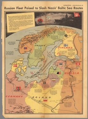


!["I Have Returned' [General MacArthur]. December 3, 1944.](https://www.davidrumsey.com/rumsey/Size1/RUMSEY~8~1/171/12272000.jpg)


![17. EXΘPIKH KATOXH-ΔIAMEΛIΣMOΣ THΣ XΩPAΣ ...[Second phase of the Occupation].](https://www.davidrumsey.com/rumsey/Size2/RUMSEY~8~1/195/14295043.jpg)
![18. AΠEΛEYΘEPΘΣIΣ. [Liberation].](https://www.davidrumsey.com/rumsey/Size2/RUMSEY~8~1/195/14295045.jpg)
![78. OI ΣΦAΓEΣ TOY ΔIΣTOMOY. [Massacres of Distomo].](https://www.davidrumsey.com/rumsey/Size1/RUMSEY~8~1/195/14295171.jpg)