|
REFINE
Browse All : Military and Pictorial map of Asia
1-7 of 7
Author
News Map of the Week, Inc.
Full Title
World News of the Week : Monday, June 1, 1942. Covering period May 22 to 28. Volume 4, No. 39. Published and copyrighted (weekly), 1942, by News Map of the Week, Inc., 1512 Orleans Street, Chicago, Illinois. Published in two sections : Section one. Lithographed in U. S. A.
List No
14101.000
Note
Lithographed world map, in color. Shows political boundaries and military events of World War II, from May 22 to 28, 1942. Relief illustrated with hachures. Includes a legend indicating the sale of defense bonds in the United States. Descriptive text throughout, e.g.: Territory coveted by Italy. Map indexed according to historical notes beneath map. Features photographs, illustrations, and international time zones. With two inset maps: (Asia) -- (Russia). Also, with diagram: Planes; Tanks; Guns; Ships. Map is 56 x 115 cm, on sheet 89 x 120 cm, folded to 31 x 23 cm.
Author
News Map of the Week, Inc.
Full Title
World News of the Week : Monday, June 8, 1942. Covering period May 29 to June 4. Volume 4, No. 40. Published and copyrighted (weekly), 1942, by News Map of the Week, Inc., 1512 Orleans Street, Chicago, Illinois. Published in two sections : Section one. Lithographed in U. S. A.
List No
14102.000
Note
Lithographed world map, in color. Shows political boundaries and military events of World War II, from May 29 to June 4, 1942. Relief illustrated with hachures. Includes a legend indicating U. S. and Japanese bases, as well as bombings by Japan. Descriptive text throughout, e.g.: Chinese advance here. Map indexed according to historical notes beneath map. Features photographs, illustrations, and international time zones. With two inset maps: (Libya and Egypt) -- (Crucial battleground). Also, with diagram: Per capita income in the United States. Map is 56 x 115 cm, on sheet 89 x 120 cm, folded to 31 x 23 cm.
Author
Shallo, Andrew, 1922-1979
Full Title
Concept of Deterrence. Rotocomic section of The Philadelphia Inquirer, Sunday, Augus 6, 1961. Inquirer map by Andrew Shallo.
List No
13583.001
Author
[Los Angeles Examiner, Burke, Howard]
Full Title
The Russian Spider Sits Atop the World and Watches for More Victims. Soviet Russia, under the Dictator Stalin, has cast aside all regard for international law and prepares to follow the Finland grab with a policy of international piracy over all Eurasia, by conquest and subversive activity.
List No
8869.000
Author
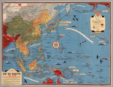
[Turner, Stanley, Petersen, C.C.]
Full Title
Dated Events. On To Tokyo. Map of the Pacific and the Far East. Stanley Turner, 44. Copyright, Canada and U.S.A., 1944, C.C. Petersen, Publishing and Advertising, Toronto, Canada. Seventh Edition.
List No
6828.000
Note
Color map, seventh edition, showing the latest activity in the Pacific Arena. On sheet 51x 66, folded as issued. Date of 1944 in marker at lower left corner. Note below title: "With this invasion map you will be able to follow the progress of the Allied armies on their way to smash Japan ..." Legend includes: American, British, Russian and Japanese Naval Bases are shown; land areas are colored to show countries under Anglo-American control, those retaken from Japan, and those under Japanese control. A fascinating map packed with information on battle dates and illustrations. Relief shown pictorially. From the collection of John Oram.
Author
[Harrison, Richard Edes, Army Orientation Course. Special Service Division Army Service Forces]
Full Title
The War Fronts. Newsmap. Monday, December 27, 1943. ... Vol. II No. 36. Prepared and Distributed by the Army Orientation Course. Morale Services Division, Army Service Forces, War Dept.,2E581 Pentagon Bldg., Washington D.C. U.S. Government Printing Office: 1943 - 538110.
List No
12026.002
Note
Shows extent of the Japanese Empire.
Author
[Manning, F.E., Army Orientation Course, Special Service Division Army Service Forces]
Full Title
Target Tokyo. Newsmap. Monday, October 18, 1943. ... Vol. II No. 26. Prepared and Distributed by the Army Orientation Course. Special Service Division Army Service Forces, War Dept.,2E581 Pentagon Bldg., Washington D.C. U.S. Government Printing Office: 1943 - 538110.
List No
6769.001
Note
Shaded relief map centered on Tokyo, Japan. Has a cut-away scale for measuring distances from Tokyo or, alternatively one can use the concentric rings. Some flight routes and mileages shown. Hemispherical view.
1-7 of 7
|