|
Author
Bacler d'Albe, Louis-Albert-Ghislain, 1761-1824
Full Title
Feuille No. XXVI Carte Générale du théâtre de la guerre en Italie et dans les Alpes
List No
15716.002
Author
Bacler d'Albe, Louis-Albert-Ghislain, 1761-1824
Full Title
Petit Tableau d'Assemblage de la Carte Générale du théâtre de la guerre en Italie.
List No
15716.003
Author
Bacler d'Albe, Louis-Albert-Ghislain, 1761-1824
Full Title
Feuille No. I (with) Feuille No. VI Carte Générale du théâtre de la guerre en Italie et dans les Alpes
List No
15716.004
Author
Bacler d'Albe, Louis-Albert-Ghislain, 1761-1824
Full Title
Feuille No. XI (with) Feuille No. XVI Carte Générale du théâtre de la guerre en Italie et dans les Alpes
List No
15716.005
Author
Bacler d'Albe, Louis-Albert-Ghislain, 1761-1824
Full Title
Feuille No. XXI Carte Générale du théâtre de la guerre en Italie et dans les Alpes
List No
15716.006
Author
Bacler d'Albe, Louis-Albert-Ghislain, 1761-1824
Full Title
Feuille No. II (with) Feuille No. VII Carte Générale du théâtre de la guerre en Italie et dans les Alpes
List No
15716.007
Author
Bacler d'Albe, Louis-Albert-Ghislain, 1761-1824
Full Title
Feuille No. XII (with) Feuille No. XVII Carte Générale du théâtre de la guerre en Italie et dans les Alpes
List No
15716.008
Author
Bacler d'Albe, Louis-Albert-Ghislain, 1761-1824
Full Title
Feuille No. XXII (with) Feuille No. XXVII Carte Générale du théâtre de la guerre en Italie et dans les Alpes
List No
15716.009
Author
Bacler d'Albe, Louis-Albert-Ghislain, 1761-1824
Full Title
Feuille No. III (with) Feuille No. VIII Carte Générale du théâtre de la guerre en Italie et dans les Alpes
List No
15716.010
Author
Bacler d'Albe, Louis-Albert-Ghislain, 1761-1824
Full Title
Feuille No. XIII (with) Feuille No. XVIII Carte Générale du théâtre de la guerre en Italie et dans les Alpes
List No
15716.011
Author
Bacler d'Albe, Louis-Albert-Ghislain, 1761-1824
Full Title
Feuille No. XXIII (with) Feuille No. XXVIII Carte Générale du théâtre de la guerre en Italie et dans les Alpes
List No
15716.012
Author
Bacler d'Albe, Louis-Albert-Ghislain, 1761-1824
Full Title
Feuille No. IV (with) Feuille No. IX Carte Générale du théâtre de la guerre en Italie et dans les Alpes
List No
15716.013
Author
Bacler d'Albe, Louis-Albert-Ghislain, 1761-1824
Full Title
Feuille No. XIV (with) Feuille No. XIX Carte Générale du théâtre de la guerre en Italie et dans les Alpes
List No
15716.014
Author
Bacler d'Albe, Louis-Albert-Ghislain, 1761-1824
Full Title
Feuille No. XXIV (with) Feuille No. XXIX Carte Générale du théâtre de la guerre en Italie et dans les Alpes
List No
15716.015
Author
Bacler d'Albe, Louis-Albert-Ghislain, 1761-1824
Full Title
Feuille No. V (with) Feuille No. X Carte Générale du théâtre de la guerre en Italie et dans les Alpes
List No
15716.016
Author
Bacler d'Albe, Louis-Albert-Ghislain, 1761-1824
Full Title
Feuille No. XV (with) Feuille No. XX Carte Générale du théâtre de la guerre en Italie et dans les Alpes
List No
15716.017
Author
Bacler d'Albe, Louis-Albert-Ghislain, 1761-1824
Full Title
Feuille No. (XXV) La Grece Ancienne, et Moderne ou Carte Generale (with) Feuille No. XXX Abrege Historique Carte Générale du théâtre de la guerre en Italie et dans les Alpes
List No
15716.018
Note
Sheet XXX has been updated to add campaigns of 1799 in a sixth column of text.
Author
Bacler d'Albe, Louis-Albert-Ghislain, 1761-1824
Full Title
Feuille No. 1 Carte Générale des Royaumes de Naples, Sicile & Sardaigne
List No
15716.020
Author
Bacler d'Albe, Louis-Albert-Ghislain, 1761-1824
Full Title
Tableau D'Assemblage (with) Canevas Generale Carte générale des Royaumes de Naples, Sicile & Sardaigne
List No
15716.021
Author
Bacler d'Albe, Louis-Albert-Ghislain, 1761-1824
Full Title
Feuille No. 4 (with) Feuille No. 5 Carte Générale des Royaumes de Naples, Sicile & Sardaigne
List No
15716.022
Author
Bacler d'Albe, Louis-Albert-Ghislain, 1761-1824
Full Title
Feuille No.12 (with) Feuille No. 13 Carte Générale des Royaumes de Naples, Sicile & Sardaigne
List No
15716.023
Author
Bacler d'Albe, Louis-Albert-Ghislain, 1761-1824
Full Title
Feuille No.20 (with) Feuille No. 21 Carte Générale des Royaumes de Naples, Sicile & Sardaigne
List No
15716.024
Author
Bacler d'Albe, Louis-Albert-Ghislain, 1761-1824
Full Title
Feuille No.3 (with) Feuille No. 6 Carte Générale des Royaumes de Naples, Sicile & Sardaigne
List No
15716.025
Author
Bacler d'Albe, Louis-Albert-Ghislain, 1761-1824
Full Title
Feuille No.11 (with) Feuille No. 14 Carte Générale des Royaumes de Naples, Sicile & Sardaigne
List No
15716.026
Author
Bacler d'Albe, Louis-Albert-Ghislain, 1761-1824
Full Title
Feuille No.19 (with) Feuille No. 22 Carte Générale des Royaumes de Naples, Sicile & Sardaigne
List No
15716.027
Author
Bacler d'Albe, Louis-Albert-Ghislain, 1761-1824
Full Title
Feuille No. 2 (with) Feuille No. 7 Carte Générale des Royaumes de Naples, Sicile & Sardaigne
List No
15716.028
Author
Bacler d'Albe, Louis-Albert-Ghislain, 1761-1824
Full Title
Feuille No. 10 (with) Feuille No. 15 Carte Générale des Royaumes de Naples, Sicile & Sardaigne
List No
15716.029
Author
Bacler d'Albe, Louis-Albert-Ghislain, 1761-1824
Full Title
Feuille No. 18 (with) Feuille No. 23 Carte Générale des Royaumes de Naples, Sicile & Sardaigne
List No
15716.030
Author
Bacler d'Albe, Louis-Albert-Ghislain, 1761-1824
Full Title
Feuille No. 8 Carte Générale des Royaumes de Naples, Sicile & Sardaigne
List No
15716.031
Author
Bacler d'Albe, Louis-Albert-Ghislain, 1761-1824
Full Title
Feuille No. 9 (with) Feuille No. 16 Carte Générale des Royaumes de Naples, Sicile & Sardaigne
List No
15716.032
Note
Feuille 16 includes top third of Carte Generale du Royaume Sardaigne
Author
Bacler d'Albe, Louis-Albert-Ghislain, 1761-1824
Full Title
Feuille No.17 (with) Feuille No. 24 Carte Générale des Royaumes de Naples, Sicile & Sardaigne
List No
15716.033
Note
Feuilles 17 and 24 include the bottom two thirds of Carte Generale du Royaume Sardaigne
Author
[Instituto de Geografía (Academia de Ciencias de Cuba), Akademiia nauk SSSR. Institut geografii.]
Full Title
Luchas armadas del pueblo Cubano por su independencia, 1868-1898. Sublevaciones armadas y Luchas en la Republica mediatzada, 1902-1952. Atlas nacional de Cuba : en el decimo aniversario de la Revolucion. La Habana 1970.
List No
13566.101
Note
2 maps on 1 sheet, with insets: Batalla de Santiago de Cuba, 188; La Habana. Maps showing armed uprising and struggles of the Cuban people for their independence.
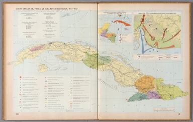
Author
[Instituto de Geografía (Academia de Ciencias de Cuba), Akademiia nauk SSSR. Institut geografii.]
Full Title
Luchas armadas del pueblo Cuba por su liberacion, 1953-1958. Atlas nacional de Cuba : en el decimo aniversario de la Revolucion. La Habana 1970.
List No
13566.102
Note
Map of Cuba, with insets: Movimientos contrarrevolucionarios previos al ataque a playa Giron (1961); Derrota del ataque contrarrevolucionario en Playa Giron, (1961). Showing Armed struggles of the Cuban people for their liberation, the battle fields, the attack by land, sea and air and defeat of the counterrevolutionary attack in Playa Giron.
Author
[Hölzel, Eduard, 1817-1885, Ed. Hölzel (Firm), Toula, Franz, 1845-1920, Chavanne, Josef, 1846-1902, Ritter, Franz, -1932]
Full Title
Karte der Territorial-Eintheilung des K. K. Heeres und der beiden Landwehren, der Vertheilung der Garnisonen sowie des Verhältnisses der Kriegsdiensttauglichkeit / von Franz Ritter von Le Monnier. Ed. Hölzel's geogr. Institut in Wien. Verlag von Ed. Hölzel in Wien.
List No
14348.049
Note
Statistical map of Austria-Hungary. Represents the distribution of military bases for Austria-Hungary. Shows political boundaries, cities, railways, roads, valleys, lakes, drainage, coastlines and islands. Includes latitudinal and longitudinal lines, as well as a legend. With two inset maps: Vertheilung der Untermässigen [= Distribution of the undersized] -- Vertheilung der Männer grossen Schlages [= Distribution of men in great numbers]. Colored lithograph. Map is 42 x 57 cm, on double sheet 49 x 65 cm. Descriptive text for Nr. 17 follows map.
Author
[Canet Alvarez, Gerardo A., 1911-, Raisz, Erwin, 1893-1968, Harvard University. Institute of Geographical Exploration, Cuba. Ministerio de Agricultura]
Full Title
Cuba colonial : Siglo XVII -- Cuba en el siglo XVIII.
List No
14350.008
Note
Two maps showing the history of Cuba in the seventeenth through nineteenth centuries. Titles translate to: Colonial Cuba : 17th century -- Cuba in the 18th century. With inset bird's-eye view, which shows the city of Havana, illustrating its topography, vegetation, roads, points of interest and coastline. Includes illustrations and descriptive text, which appears in Spanish, with English translations. Accompanied by a timeline on left, which spans the dates 1600 to 1825 and lists historical events.
Author
[Canet Alvarez, Gerardo A., 1911-, Raisz, Erwin, 1893-1968, Harvard University. Institute of Geographical Exploration, Cuba. Ministerio de Agricultura]
Full Title
Cuba insurrecta : Primeras luchas -- La guerra del '68 -- La guerra del '95.
List No
14350.009
Note
Three maps showing the history of Cuba in the nineteenth and twentieth centuries. Titles translate to: Insurrectionary Cuba : First struggles -- The war of '68 -- The war of '95. Maps show cities, coastlines and locations of military events. Maps include pictorial elements and descriptive text, which appears in Spanish, with English translations. Accompanied by a timeline on left, which spans the dates 1840 to 1940 and lists historical events. With illustrations, charts and diagram, which represents population.
Author
[Glinka, Grigorii Viacheslavich, 1862-1934, Russia. Pereselencheskoe upravlenīe.]
Full Title
No. No. 10. Karta Pravoslavnaya Eparkhiya Aziatskoi Rossii. 11. Karta Voennykh' Okrugav' Aziatskoi Rossii. 12. Karta Okrugov' sude'nykh' palat' v Aziatskoi Rossii. 13. Karta Uchebnykh Okrugov Aziatskoi Rossii. (to accompany) Atlas Aziatskoi Rossii. Izdanie. 1914.
List No
13437.023
Note
4 maps on double page plates, including Asian Russia's Orthodox Diocese, Military Districts, Judicial Districts, and educational districts. Including color coded reference.
Author
Aspioti-ELKA (Firm)
Full Title
EΛΛHNOÏTAΛIKOΣ ΠOΛEMOΣ : ΠPΩTH ΠEPIOΔOΣ 28/10/1940-8/11/1940.
List No
14295.029
Note
Colored map of Greece, showing Italian military attacks on Greece from August 11th, 1940 to October 28th, 1940. Delineates between Greek and Albanian territory, where each suffered "Italian penetration". Also shows international political borders, cities, coastlines and islands. Includes a scale statement and an indexed legend, which the descriptive text on facing page explains. Accompanying text appears in Greek, French, English and Russian, entitled, The Italian agression. Description begins: But destiny prevented the Greek people from living and working in its poor country which he developed by his own toil ... Map is 39 x 31 cm, on sheet 47 x 35 cm. (Plate number 10, according to descriptive text.) Within the second section of the atlas, Greece at war.
Author
Aspioti-ELKA (Firm)
Full Title
EΛΛHNOΓEPMANIKOΣ ΠOΛEMOΣ : ΠPΩTH ΠEPIOΔOΣ 6 ATTP. - 17 ATTP. 1941.
List No
14295.033
Note
Colored map of Greece, showing German military attacks on Greece from April 6th to 17th, 1941. Delineates between German offensives during April 6-12 and April 13-17, 1941. First in a series of three maps that represent German attacks on Greece in 1941. Also shows international political borders, cities, coastlines and islands. Includes a scale statement and an indexed legend, which the descriptive text on facing page explains. Accompanying text appears in Greek, French, English and Russian, entitled, German attack A. Description begins: But the big Italian concentrations and Mussoini's spring offensives were all of no avail ... Map is 39 x 31 cm, on sheet 47 x 35 cm. (Plate number 12, according to descriptive text.) Within the second section of the atlas, Greece at war.
Author
Aspioti-ELKA (Firm)
Full Title
EXΘPIKH KATOXH-ΔIAMEΛIΣMOΣ THΣ XΩPAΣ : ΠPΩTH ΠEPIOΔOΣ 1941-1942.
List No
14295.039
Note
Colored map of Greece, showing the Italian, German and Bulgarian Occupation of Greece from 1943 to 1944. Delineates between the areas occupied by the Italians, Germans and Bulgarian. First in a series of four maps that represent military activity in Greece from 1941 to 1944. With national flags indicating boundaries. Also shows international political borders, cities, coastlines and islands. Includes a scale statement and an indexed legend, which the descriptive text on facing page explains. Accompanying text appears in Greek, French, English and Russian, entitled, Second phase of the Occupation. Description begins: At once the axis forces divided Greece into many zones and allocated them to the Germans, the Italians and the Bulgarians, who fell on the corpse of Greece in order to secure their reward for the assistance they gave to the Germans ... Map is 39 x 31 cm, on sheet 47 x 35 cm. (Plate number 15, according to descriptive text.) Within the second section of the atlas, Greece at war.
Author
Aspioti-ELKA (Firm)
Full Title
ΔIAMEΛIΣMOΣ THΣ XΩPAΣ KATA THN KATOXH : KAI OIKONOMIKH AΠOMONΩΣH TΩN ΔIAΦOPΩN ΠEPIOXΩN THΣ.
List No
14295.041
Note
Colored map of Greece, showing the dismemberment of Greece, circa 1942. Delineates between economic barriers, Bulgarian annexation, Italian occupation and Italian annexation. Second in a series of four maps that represent military activity in Greece from 1941 to 1944. Also shows international political borders, cities, coastlines and islands. Includes a scale statement and an indexed legend, which the descriptive text on facing page explains. Accompanying text appears in Greek, French, English and Russian, entitled, The dismemberment of the country. Description begins: With the division of the country into zones of Occupation the Axis divided Greece into small states ... Map is 39 x 31 cm, on sheet 47 x 35 cm. (Date based upon previous map in series.) (Plate number 16, according to descriptive text.) Within the second section of the atlas, Greece at war.
Author
Aspioti-ELKA (Firm)
Full Title
ΛAPIΣA-KATAΣTPOΦEΣ.
List No
14295.108
Note
Colored map of Greece, showing the damage inflicted by Axis bombings on the city of Larissa during World War II. Delineates between complete destruction, severe and slight damage, as well as areas left untouched. Also shows city plan, drainage, coastline and port. Includes a bar scale and an indexed legend, which the descriptive text on facing page explains. Accompanying text appears in Greek, French, English and Russian, entitled, Larissa. Description begins: Larissa, the chief centre of Thessaly, was the principal Axis target in Eastern Greece. Destruction swept the whole town ... Map is 29 x 44 cm, on sheet 35 x 47 cm. (Plate number 48, according to descriptive text.) Within the fifth section of the atlas, Damage to towns and villages.
Author
Aspioti-ELKA (Firm)
Full Title
TA KAMMENA XΩPIA.
List No
14295.118
Note
Colored map of Greece, showing the villages burned by Axis Powers during World War II. Also shows international political borders, cities, coastlines and islands. Includes a scale statement. Accompanied by descriptive text on facing page in Greek, French, English and Russian, entitled, Burned villages. Description begins: As if all other catastrophes were not sufficient, the occupying forces applied a systematic plan for the destruction of Hellenism: the burning of villages ... Map is 39 x 31 cm, on sheet 47 x 35 cm. (Plate number 53, according to descriptive text.) Within the fifth section of the atlas, Damage to towns and villages.
Author
Aspioti-ELKA (Firm)
Full Title
ΣΦAΓEΣ KAI EMПPHΣMOΣ KAΛABPYTΩN : TA ПYPПOΛHΘENTA KAΛABPYTA.
List No
14295.169
Note
Colored chart and map of Greece, showing the massacre of Kalavryta by the Germans during World War II. Map shows city plan, roads, topography and drainage. Relief shown with contour lines. Includes a legend. Accompanied by descriptive text on facing page in Greek, French, English and Russian, entitled, The massacres of Kalavryta. Description begins: The Germans applied a systematic programme of slaughter ... Within the sixth section of the atlas, The sufferings of the inhabitants ... Together, chart and map are 40 x 31 cm, on sheet 47 x 35 cm. (Plate number 77, according to descriptive text.) Within the sixth section of the atlas, The sufferings of the inhabitants.
Author
Aspioti-ELKA (Firm)
Full Title
ΔIΩΓMOI EBPAIΩN.
List No
14295.183
Note
Colored map of Greece, showing the persecution of the Jews during World War II. Delineates between flights of Jews to different areas, including Poland and the Middle East, as well as those who went to concentration camps. Also shows international political borders, cities, coastlines and islands. Includes an indexed legend, which the descriptive text on facing page explains. Accompanying text appears in Greek, French, English and Russian, entitled, The persecution of the Jews. Description begins: The worst of all persecutions were those of the Jews ... Map is 39 x 31 cm, on sheet 47 x 35 cm. (Plate number 84, according to descriptive text.) Within the sixth section of the atlas, The sufferings of the inhabitants.
Author
[Paullin, Charles O., Wright, John K.]
Full Title
Plate 160. Military History. The American Revolution, 1775 - 1783. 1775 - 1776. 1777. 1778 - 1779. Naval Battles, 1776 - 1800, War of the Revolution and War with France. The South, 1778 - 1779. The South, 1780. New York and New Jersey, 1780, Greene's Campaigns, 1781. 1781, Yorktown, 1781.
List No
0702.163
Author
[Paullin, Charles O., Wright, John K.]
Full Title
Plate 161. Military History. Colonial Wars, 1689 - 1754. Colonial Wars, 1755 - 1763.
List No
0702.164
Author
[Paullin, Charles O., Wright, John K.]
Full Title
Plate 162. Military History. 1812. Jackson's Campaigns 1813 - 1815. War of 1812. 1814. Niagara Campaign, 1814. Chesapeake Campaign, 1814. Coast Towns Harassed by British 1813-1814. Naval Battles, 1811 - 1815. Texan Campaigns, 1835 - 1836. Mexican War, 1846 - 1847. Vicinity of Mexico City, 1847. Vera Cruz to Mexico City, 1847. Vera Cruz and Yucatan. Palo ALto to Buena Vista, 1846 - 1847.
List No
0702.165
Author
[Paullin, Charles O., Wright, John K.]
Full Title
Plate 163. Military History. Civil War 1861 - 1865. 1861 - 1862. 1863. 1864 - 1865. Conquest of the South 1861 - 1865.
List No
0702.166
Author
[Paullin, Charles O., Wright, John K.]
Full Title
Plate 164. Military History. Virginia Campaigns, 1862. Virginia Campaigns, 1863. Virginia Campaigns 1864 - 1865. Sucession 1860 - 1861. Reconstruction, 1861 - 1877.
List No
0702.167
|


![10. EΛΛHNOÏTAΛIKOΣ ΠOΛEMOΣ ...[The Italian aggression].](https://www.davidrumsey.com/rumsey/Size1/RUMSEY~8~1/195/14295029.jpg)
![12. EΛΛHNOΓEPMANIKOΣ ΠOΛEMOΣ ...[German attack A].](https://www.davidrumsey.com/rumsey/Size2/RUMSEY~8~1/195/14295033.jpg)
![15. EXΘPIKH KATOXH-ΔIAMEΛIΣMOΣ THΣ XΩPAΣ ...[The first phase of Occupation].](https://www.davidrumsey.com/rumsey/Size1/RUMSEY~8~1/195/14295039.jpg)
![16. ΔIAMEΛIΣMOΣ THΣ XΩPAΣ KATA THN KATOXH ...[The dismemberment of the country].](https://www.davidrumsey.com/rumsey/Size2/RUMSEY~8~1/195/14295041.jpg)
![48. ΛAPIΣA-KATAΣTPOΦEΣ. [Larissa].](https://www.davidrumsey.com/rumsey/Size2/RUMSEY~8~1/195/14295108.jpg)
![53. TA KAMMENA XΩPIA. [Burned villages].](https://www.davidrumsey.com/rumsey/Size1/RUMSEY~8~1/195/14295118.jpg)
![77. ΣΦAΓEΣ KAI EMПPHΣMOΣ KAΛABPYTΩN ...[The massacres of Kalavryta].](https://www.davidrumsey.com/rumsey/Size2/RUMSEY~8~1/195/14295169.jpg)
![84. ΔIΩΓMOI EBPAIΩN. [The persecution of the Jews].](https://www.davidrumsey.com/rumsey/Size2/RUMSEY~8~1/195/14295183.jpg)


