|
REFINE
Browse All : Military and Atlas Map and Military Atlas of United States from U.S. Civil War
1-12 of 12
Author
[Československá akademie věd., Klíma, Jan]
Full Title
Sjednocení Itálie (1850-1870) - Občanská valka v USA (1861-1865). Československý vojenský atlas.
List No
13684.219
Note
2 Timeline maps, with 4 inset maps, text and legends, on 1 sheet. Showing 1850-1870 Unification of Italy. And American Civil War from 1861-1865. 1866 Austro-Prussian War and Austrian Empire and Kingdom of Italy war in 1866.
Author
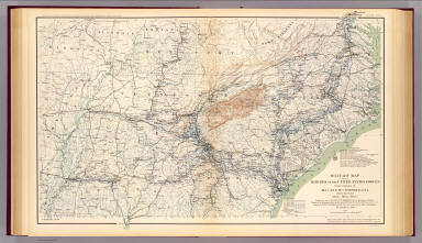
[Jenney, William LeB., United States. War Department]
Full Title
Military map of the marches of the United States forces under command of Maj. Gen. W.T. Sherman, U.S.A. during the years 1863, 1864, 1865. Compiled by order of Maj. Gen. W.T. Sherman ... under the direction of Bvt. Maj. W.L.B. Jenney ... Drawn by Capt. William Kossak ... and John B. Muller, draughtsman. St. Louis, Mo., 1865. Julius Bien & Co., Lith., N.Y. (1891-1895)
List No
1780.117
Note
Col. map. Relief shown by hachures. Shows settlements, roads, railroads, fortifications, etc.
Author
Julius Bien & Co.
Full Title
Map of the United States of America showing the boundaries of the Union and Confederate geographical divisions and departments, Dec. 31, 1860. Julius Bien & Co., Lith., N.Y. (1891-1895)
List No
1780.165
Note
Col. map. Relief shown by hachures and spot heights. Shows states, settlements, rivers, railroads, etc.
Author
Julius Bien & Co.
Full Title
Map of the United States of America showing the boundaries of the Union and Confederate geographical divisions and departments, June 30, 1861. Julius Bien & Co., Lith., N.Y. (1891-1895)
List No
1780.166
Note
Col. map. Relief shown by hachures and spot heights. Shows states, settlements, rivers, railroads, etc.
Author
Julius Bien & Co.
Full Title
Map of the United States of America showing the boundaries of the Union and Confederate geographical divisions and departments, Dec. 31, 1861. Julius Bien & Co., Lith., N.Y. (1891-1895)
List No
1780.167
Note
Col. map. Relief shown by hachures and spot heights. Shows states, settlements, rivers, railroads, etc.
Author
Julius Bien & Co.
Full Title
Map of the United States of America showing the boundaries of the Union and Confederate geographical divisions and departments, June 30, 1862. Julius Bien & Co., Lith., N.Y. (1891-1895)
List No
1780.168
Note
Col. map. Relief shown by hachures and spot heights. Shows states, settlements, rivers, railroads, etc.
Author
Julius Bien & Co.
Full Title
Map of the United States of America showing the boundaries of the Union and Confederate geographical divisions and departments, Dec. 31, 1862. Julius Bien & Co., Lith., N.Y. (1891-1895)
List No
1780.169
Note
Col. map. Relief shown by hachures and spot heights. Shows states, settlements, rivers, railroads, etc.
Author
Julius Bien & Co.
Full Title
Map of the United States of America showing the boundaries of the Union and Confederate geographical divisions and departments, June 30, 1863. Julius Bien & Co., Lith., N.Y. (1891-1895)
List No
1780.170
Note
Col. map. Relief shown by hachures and spot heights. Shows states, settlements, rivers, railroads, etc.
Author
Julius Bien & Co.
Full Title
Map of the United States of America showing the boundaries of the Union and Confederate geographical divisions and departments, Dec. 31, 1863. Julius Bien & Co., Lith., N.Y. (1891-1895)
List No
1780.171
Note
Col. map. Relief shown by hachures and spot heights. Shows states, settlements, rivers, railroads, etc.
Author
Julius Bien & Co.
Full Title
Map of the United States of America showing the boundaries of the Union and Confederate geographical divisions and departments, June 30, 1864. Julius Bien & Co., Lith., N.Y. (1891-1895)
List No
1780.172
Note
Col. map. Relief shown by hachures and spot heights. Shows states, settlements, rivers, railroads, etc.
Author
Julius Bien & Co.
Full Title
Map of the United States of America showing the boundaries of the Union and Confederate geographical divisions and departments, Dec. 31, 1864. Julius Bien & Co., Lith., N.Y. (1891-1895)
List No
1780.173
Note
Col. map. Relief shown by hachures and spot heights. Shows states, settlements, rivers, railroads, etc.
Author
Julius Bien & Co.
Full Title
Map of the United States of America showing the boundaries of the Union and Confederate geographical divisions and departments, April 9, 1865. Julius Bien & Co., Lith., N.Y. (1891-1895)
List No
1780.174
Note
Col. map. Relief shown by hachures and spot heights. Shows states, settlements, rivers, railroads, etc.
1-12 of 12
|