|
Author
[Weekly Dispatch, Dower, John, active 1838-1846?]
Full Title
Sardinia, Piedmont, Savoy, &c. Parma & Modena : War map / by John Dower, F. R. G. S. ; drawn & engraved by John Dower, Pentonville Hill, London ; Day & Son Lithrs. to The Queen.
List No
14360.170
Note
Map of Sardinia, Italy, featuring military history, such as battle sites, fortified cities and fortresses. Shows political boundaries, cities, railways, roads, canals, topography, bodies of water, drainage and islands. Relief shown with hachures. Includes latitudinal and longitudinal lines, as well as a legend and two bar scales given in English, geographical and Italian miles. Hand-colored lithograph. Map is 30 x 43 cm, on sheet 33 x 48 cm. Plate number handwritten in ink at upper left corner of sheet; "15/5/59" in pencil at bottom of sheet. Appears in Vol. II : Foreign.
Author
[Weekly Dispatch, Dower, John, active 1838-1846?]
Full Title
Lombardy and Venice : War map / by John Dower, F. R. G. S. ; drawn & engraved by John Dower, Pentonville Hill, London ; Day & Son Lithrs. to The Queen.
List No
14360.172
Note
Map of Lombardy and Venice, Italy, featuring military history, such as battle sites, fortified cities and fortresses. Shows political boundaries, cities, railways, roads, canals, topography, bodies of water, drainage and islands. Relief shown with hachures. Includes latitudinal and longitudinal lines, as well as a legend and two bar scales given in English, geographical and Italian miles. Hand-colored lithograph. Map is 29 x 45 cm, on sheet 33 x 48 cm. Plate number handwritten in ink at upper left corner of sheet; "5/6/59" in pencil at bottom of sheet. Appears in Vol. II : Foreign.
Author
[Weekly Dispatch, Dower, John, active 1838-1846?]
Full Title
Naples : Southern portion and Sicily. Northern portion. / by John Dower, F. R. G. S. ; drawn & engraved by John Dower, Pentonville Road, London ; Day & Son Lithrs. to The Queen.
List No
14360.174
Note
Map of Naples, Italy (southern portion and Sicily, and northern sheets). Shows political boundaries, cities, battle sites, railways, roads, canals, topography, bodies of water, drainage and islands. Relief shown with hachures. Includes latitudinal and longitudinal lines, as well as legends and bar scales given in English, geographical and Italian miles. With inset map: The Maltese Islands. Hand-colored lithograph. Map is 61 x 43 cm, on two sheets, together 69 x 48 cm. Sheets presented in sequence. Appears in Vol. II : Foreign.
Author
[Weekly Dispatch, Dower, John, active 1838-1846?]
Full Title
Switzerland : (East) sheet 2 (West) sheet 1. / by John Dower, F. R. G. S. ; drawn & engraved by John Dower, Pentonville, London ; Day & Son Lithrs. to The Queen.
List No
14360.176
Note
Map of Switzerland (east and west sheets). Shows political boundaries, cities, battle sites, railways, roads, canals, topography, glaciers, bodies of water, waterfalls and drainage. Relief shown with hachures. Includes latitudinal and longitudinal lines, as well as a legend and bar scale and scale statement given in English miles. Hand-colored lithograph. Map is 42 x 62 cm, on two sheets, together 48 x 69 cm. Sheets presented in sequence. Appears in Vol. II : Foreign.
Author
[Weekly Dispatch, Dower, John, active 1838-1846?]
Full Title
(Composite Map to) Switzerland : (East) sheet 2 -- (West) sheet 1 / by John Dower, F. R. G. S. ; drawn & engraved by John Dower, Pentonville, London ; Day & Son Lithrs. to The Queen.
List No
14360.177
Note
Composite map of Switzerland (east and west sheets). Shows political boundaries, cities, battle sites, railways, roads, canals, topography, glaciers, bodies of water, waterfalls and drainage. Relief shown with hachures. Includes latitudinal and longitudinal lines, as well as a legend and bar scale and scale statement given in English miles. Hand-colored lithograph. Map is 42 x 62 cm, on two sheets, together 48 x 69 cm. Sheets presented in sequence. Appears in Vol. II : Foreign.
Author
[Weekly Dispatch, Dower, John, active 1838-1846?]
Full Title
The great fortresses of Lombardo-Venetia, with the line of the Mincio / drawn & engraved by John Dower, 28, Ludgate Str. E. C. ; Day & Son Lithrs. to The Queen.
List No
14360.178
Note
Map of Lombardo-Venetia and the Mincio River, Italy, featuring fortresses. Shows political boundaries, cities, railways, roads, canals, bodies of water, drainage and islands. Includes latitudinal and longitudinal lines, as well as a bar scale given in English miles. Hand-colored lithograph. Map is 30 x 42 cm, on sheet 33 x 48 cm. Plate number handwritten in ink at upper left corner of sheet; "3/7/59" in pencil at bottom of sheet. Appears in Vol. II : Foreign.
Author
[Weekly Dispatch, Dower, John, active 1838-1846?]
Full Title
The battle fields of Northern Italy / drawn & engraved by John Dower, 28, Ludgate Str. E. C. ; Day & Son Lithrs. to The Queen.
List No
14360.179
Note
Map of Northern Italy, featuring battle fields. Shows political boundaries, cities, railways, roads, canals, bodies of water, drainage and islands. Includes latitudinal and longitudinal lines, as well as a bar scale given in English miles. Hand-colored lithograph. Map is 32 x 42 cm, on sheet 33 x 48 cm. Plate number handwritten in ink at upper left corner of sheet; "12/8/59" in pencil at bottom of sheet. Appears in Vol. II : Foreign.
Author
Geological Survey (U.S.)
Full Title
Battle sites / compiled by U. S. Geological Survey, 1967.
List No
14359.104
Note
Historical map representing the United States, featuring battle sites from the French and Indian Wars, the American Revolution, the War of 1812, the Indian Wars, the Mexican War, the Civil War and World War II. Shows political boundaries, cities, topography, bodies of water, drainage, coastlines and islands. Relief shown pictorially. Includes a legend, latitudinal and longitudinal lines, as well as a bar scale and scale statement. Presented with Albers Equal Area Projection. With three inset maps: [Chesapeake Bay] -- Principal islands of Hawaii -- Alaska. Colored lithograph. Map is 43 x 66 cm, on double sheet 49 x 71 cm. Accompanying descriptive text on page 129. Appears in Special subject maps section, subsection History.
Author
[Geological Survey (U.S.), U.S. Census Bureau, National Geographic Society (U.S.)]
Full Title
Untied States foreign service and other selected posts and missions, status as of June 30, 1970 / compiled by U. S. Dept. of State: U. S. Foreign service posts and Department of State jurisdictions, map; Foreign Service list, no. 7802, Washington, U. S. Govt. Print. Off., Jan. 1, 1970; and data updated by supplementary information to June 30, 1970. Base map by National Geographic Society, The world, 1:63,360,000; rev. by U. S. Geol. Survey, 1968.
List No
14359.252
Note
World map featuring United States foreign service and other posts and missions, as of June 30, 1970. Shows Peace Corps posts, U. S. Information Agencies and embassies, as well as national borders, cities, bodies of water, glaciers, coastlines and islands. Includes latitudinal and longitudinal lines, as well as a legend, bar scale and scale statement. With inset map: Western Europe. Presented with Van der Grinten Projection. Colored lithograph. Map is 42 x 65 cm, on double sheet 49 x 71 cm. Appears in Special subject maps section, subsection World.
Author
[El Lissitsky, Rodionov, F. E.]
List No
15162.001
Author
[El Lissitsky, Rodionov, F. E.]
Full Title
(Title page to) Raboche-Krest’ianskaia Krasnaia Armiia. [Red Army of Workers and Peasants].
List No
15162.003
Author
[El Lissitsky, Rodionov, F. E.]
Full Title
(Title page to) Raboche-Krest’ianskaia Krasnaia Armiia. [Red Army of Workers and Peasants].
List No
15162.004
Author
[El Lissitsky, Rodionov, F. E.]
Full Title
(Untitled View to) Raboche-Krest’ianskaia Krasnaia Armiia. [Red Army of Workers and Peasants].
List No
15162.007
Author
[El Lissitsky, Rodionov, F. E.]
Full Title
(Untitled View to) Raboche-Krest’ianskaia Krasnaia Armiia. [Red Army of Workers and Peasants].
List No
15162.006
Author
[El Lissitsky, Rodionov, F. E.]
Full Title
(Composite View to) Raboche-Krest’ianskaia Krasnaia Armiia. [Red Army of Workers and Peasants].
List No
15162.105
Note
Entire volume in multipage composite image.
Author
[El Lissitsky, Rodionov, F. E.]
Full Title
(Composite View to) Raboche-Krest’ianskaia Krasnaia Armiia. [Red Army of Workers and Peasants].
List No
15162.107
Note
Entire volume in multipage PDF.
Author
[Glinka, Grigorii Viacheslavich, 1862-1934, Russia. Pereselencheskoe upravlenīe.]
Full Title
No. No. 10. Karta Pravoslavnaya Eparkhiya Aziatskoi Rossii. 11. Karta Voennykh' Okrugav' Aziatskoi Rossii. 12. Karta Okrugov' sude'nykh' palat' v Aziatskoi Rossii. 13. Karta Uchebnykh Okrugov Aziatskoi Rossii. (to accompany) Atlas Aziatskoi Rossii. Izdanie. 1914.
List No
13437.023
Note
4 maps on double page plates, including Asian Russia's Orthodox Diocese, Military Districts, Judicial Districts, and educational districts. Including color coded reference.
Author
[Glinka, Grigorii Viacheslavich, 1862-1934, Russia. Pereselencheskoe upravlenīe.]
Full Title
No. 37. Karta zemel' Kazach'ikh voysk. (to accompany) Atlas Aziatskoi Rossii. Izdanie. 1914.
List No
13437.062
Note
6 maps on double page plate, showing the lands of Cossack troops. Includes conventional singes.
Author
[Canet Alvarez, Gerardo A., 1911-, Raisz, Erwin, 1893-1968, Harvard University. Institute of Geographical Exploration, Cuba. Ministerio de Agricultura]
Full Title
Cuba colonial : Siglo XVII -- Cuba en el siglo XVIII.
List No
14350.008
Note
Two maps showing the history of Cuba in the seventeenth through nineteenth centuries. Titles translate to: Colonial Cuba : 17th century -- Cuba in the 18th century. With inset bird's-eye view, which shows the city of Havana, illustrating its topography, vegetation, roads, points of interest and coastline. Includes illustrations and descriptive text, which appears in Spanish, with English translations. Accompanied by a timeline on left, which spans the dates 1600 to 1825 and lists historical events.
Author
[Canet Alvarez, Gerardo A., 1911-, Raisz, Erwin, 1893-1968, Harvard University. Institute of Geographical Exploration, Cuba. Ministerio de Agricultura]
Full Title
Cuba insurrecta : Primeras luchas -- La guerra del '68 -- La guerra del '95.
List No
14350.009
Note
Three maps showing the history of Cuba in the nineteenth and twentieth centuries. Titles translate to: Insurrectionary Cuba : First struggles -- The war of '68 -- The war of '95. Maps show cities, coastlines and locations of military events. Maps include pictorial elements and descriptive text, which appears in Spanish, with English translations. Accompanied by a timeline on left, which spans the dates 1840 to 1940 and lists historical events. With illustrations, charts and diagram, which represents population.
Author
[Baranov, A., Gosizdat, otdel voennoi literatury]
Full Title
Likvidatsiia Kolchaka i ego posledyshei [i.e. Liquidation of Kolchak and His Followers]
List No
15013.000
Author
Anonymous
Full Title
Haikou Quantu 海口全圖 [Complete Map of Sea Ports]. Wanguo tu & Wukou Yanhai Shuilu Quantu 萬國圖 & 五口沿海水路全圖 [Map of 10,000 Countries & Complete Map of the Five Coastal Estuaries].
List No
15039.003
Author
[Chatelain Henri, 1684-1743, Gueudeville, Nicolas]
Full Title
Carte pour servir a l'intelligence de l'histoire de Gustave Adolphe, de Christine, de Charles Gustave et de Charles XII. Tome 4. No. 11. (to accompany) Atlas Historique ... Tome IV. A Amsterdam, chez les Freres Chatelain Libraires. M DCC XIV (1714).
List No
13272.367
Note
2 engraved maps on 1 sheet: Carte des conquestes du Grand Gustave en Allemagne; Carte des conquestes de Charles Gustave et de Charles XII en Pologne. Includes a view: Bergae Norvegiae. Includes descriptive text on histories of battles fought.
Author
[United States. Army. Corps of Engineers, Wheeler, G.M.]
Full Title
Sketch of Beaver, Utah showing position of astronomical monument. Sketch of Cheyenne, Wyoming showing position of astronomical monument. Sketch of Fort Union, New Mexico showing position of astronomical monument. Sketch of Georgetown, Colorado showing position of astronomical monument and meridian mark. Sketch of St. George, Utah showing position of astronomical monument. Military reservation, Santa Fe, New Mexico showing position of astronomical monument. Expeditions of 1872, 1873, 1874, 1875 & 1876, under the command of 1st Lieut. Geo. M. Wheeler, Corps of Engineers, U.S. Army. U.S. Geographical Surveys West of the 100th Meridian. George D. Clarke, del. The Graphic Co., N.Y. By order of the honorable the Secretary of War, under the direction of Brig. Gen. A.A. Humphreys, Chief of Engineers, U.S. Army. (1877)
List No
2220.047
Note
Six sepia tone lithographed maps. Show buildings, railroad, un-named streets, etc. Surveyed 1872-1875.
Author
Vermessungs- Und Karten-Abteilung (Mot.) 608. [German Army - Motorized Surveying & Map Detachment 608].
Full Title
Sheet 1 Bildplanskizze der Stadt Kiew 1:20 000
List No
10839.001
Author
Vermessungs- Und Karten-Abteilung (Mot.) 608. [German Army - Motorized Surveying & Map Detachment 608].
Full Title
Sheet 2 Bildplanskizze der Stadt Kiew 1:20 000
List No
10839.002
Author
Vermessungs- Und Karten-Abteilung (Mot.) 608. [German Army - Motorized Surveying & Map Detachment 608].
Full Title
Sheet 1-2 Bildplanskizze der Stadt Kiew 1:20 000
List No
10839.003
Note
Sheets 1 and 2 joined.
Author
Generalstab Des Heeres, Abteilung Für Kreigskarten Und Vermessungswesen (General Staff of the Army, Department for District Maps and Surveying
Full Title
Stadtplan von Stalingrad.
List No
10842.001
Author
Generalstab Des Heeres, Abteilung Für Kreigskarten Und Vermessungswesen (General Staff of the Army, Department for District Maps and Surveying
Full Title
Mil-Geo-Karte of Stalingrad
List No
10842.002
Author
Turner, Stanley
Full Title
War in Europe Dated Events. (WWII Pacific theaters of War). Stanley Turner. Printed in U.S.A. International circulation Company, Inc., New York City. Copyright, Canada and U.S.A. 1944, C.C. Peterson, publishing and advertising, Toronto, ONT.
List No
13579.001
Author
Turner, Stanley
Full Title
(WWII Pacific theaters of War). War in Europe Dated Events. Stanley Turner. Printed in U.S.A. International circulation Company, Inc., New York City. Copyright, Canada and U.S.A. 1944, C.C. Peterson, publishing and advertising, Toronto, ONT.
List No
13579.002
Author
[United States. Army Orientation Course, United States. Bureau of Naval Personnel. Educational Services]
Full Title
The world at war. February 1943. Prepared and Distributed by Army Orientation Course, Special Service Division ... Washington, D.C. Navy distribution by Educational Services, BuPers, Navy Dept. ... (on verso) News map. Monday, February 8, 1943; week of January 29 to February 5; Volume 1, No. 2. Navy distribution by Educational Services, Bureau of Personnel, Navy Dept. U.S. Government Printing Office, 1943 - 469049.
List No
13580.001
Author
[United States. Army Orientation Course, United States. Bureau of Naval Personnel. Educational Services]
Full Title
The world at war. February 1943. Prepared and Distributed by Army Orientation Course, Special Service Division ... Washington, D.C. Navy distribution by Educational Services, BuPers, Navy Dept. ... (on verso) News map. Monday, February 8, 1943; week of January 29 to February 5; Volume 1, No. 2. Navy distribution by Educational Services, Bureau of Personnel, Navy Dept. U.S. Government Printing Office, 1943 - 469049.
List No
13580.002
Author
United States. Army Service Forces. Army Information Branch.
Full Title
Newsmap for the Armed Forces : V-E Day + 15 weeks - 192nd .Week of U.S. participation in the War. The knockout blows fall. Prepared and distributed by Army Information Branch, Army Service Forces. Navy Distribution and Educational Services Section, Bupers, Navy Dept., Washington, D.C. Monday, 20 August, 1945, week of 7 August to 14 August - Volume IV No. 18F. (on verso) Advance Base Sectional Docks.
List No
13584.001
Author
United States. Army Service Forces. Army Information Branch.
Full Title
Newsmap for the Armed Forces : V-E Day + 15 weeks - 192nd Week of U.S. participation in the War. The knockout blows fall. Prepared and distributed by Army Information Branch, Army Service Forces. Navy Distribution and Educational Services Section, Bupers, Navy Dept., Washington, D.C. Monday, 20 August, 1945, week of 7 August to 14 August - Volume IV No. 18F. (on verso) Advance Base Sectional Docks.
List No
13584.002
Author
C.S. Hammond & Co.
Full Title
"A heaven born dream" "Europe at Peace!" (in 1920?). F.A. Ferris & Company, New York City, U.S.A. Map series No. 18. With the compliments of F.A. Ferris & Company, New York City, U.S.A. Hammond's Map of Europe Copyright 1915, by C.S. Hammond & Co., N.Y.
List No
13575.002
Author
C.S. Hammond & Co.
Full Title
The crater of hell : Belgium, France, Germany as it is June 1st, 1917. F.A. Ferris & Company, New York City, U.S.A. Map series No. 19. With the compliments of F.A. Ferris & Company, New York City, U.S.A. Copyright, C.S. Hammond & Co., N.Y.
List No
13576.002
Author
C.S. Hammond & Co.
Full Title
(Covers to) Map series No. 20. The murderer's hand and the world's response, September 1917. With the compliments of F.A. Ferris & Company, New York City, U.S.A. C.S. Hammond & Co., N.Y.
List No
13577.001
Author
C.S. Hammond & Co.
Full Title
Map series No. 20. The murderer's hand and the world's response, September 1917. With the compliments of F.A. Ferris & Company, New York City, U.S.A. C.S. Hammond & Co., N.Y.
List No
13577.002
Author
C.S. Hammond & Co.
Full Title
A Europe of liberty and peace for every nation : As sought by Premier Lloyd george of England, Premier George Clemenceau of France, President Woodrow Wilson of the United States. With the compliments of F.A. Ferris & Company, New York City, U.S.A. Hammond's map of Europe. Copyright 1915. by C.S. Hammond & Co., N.Y.
List No
13578.002
Author
J.H. Stuart & Co.
Full Title
Map of Camp Benson, G.A.R. Association, Newport, Maine. (1894)
List No
0966.041
Note
Hand colored lithographed map. Shows lots, buildings, landowners, etc.
Author
[Chatelain Henri, 1684-1743, Gueudeville, Nicolas]
Full Title
Nouvelle carte des ordres militaires ou de chevalerie iInstitues par divers princes pour recompenser le merite ou la vertu de leurs sujets ou par reconnoissance de quelque signalee victoire. Tom. 7. No.40. (to accompany) Atlas Historique ... A Amsterdam, chez L'Honore & Chatelain Libraires. M DCC XX (1720).
List No
13272.870
Note
New folded map, presenting military or chivalry orders instituted by various Princes to reward their subjects by recognition of a victory. Includes historical remarks and tables.
Author
[Chatelain Henri, 1684-1743, Gueudeville, Nicolas]
Full Title
Carte pour contribuer à indiquer la connoissance des premiers principes des Portifications ainsi que l'ordre de l'attaque & de la defense des Places ... Tom. 7. No. 41. (to accompany) Atlas Historique ... A Amsterdam, chez L'Honore & Chatelain Libraires. M DCC XX (1720).
List No
13272.873
Note
Engraved folded map and views, showing various models and principles of the fortifications, defenses, weapons, helmets and various weapons making tools. Includes detailed explanation below.
Author
News Map of the Week, Inc.
Full Title
World News of the Week : Monday, Dec. 10, 1945. Covering period Nov. 30 to Dec. 6. Volume 8, No. 15. Published and copyrighted (weekly), 1945, by News Map of the Week, Inc., 1512 Orleans Street, Chicago, Illinois.
List No
10859.000
Note
Inset map and text shows the attack on Pearl Harbor that occurred four years prior to the date of this map.
Author
[Turner, Stanley, Petersen, C.C.]
Full Title
Dated events invasion map of fortress Europe. Stanley turner, 44. Seventh Edition. Printed in U.S.A. International Circulation Company. Copyright Canada and U.S.A. 1944, C.C. Petersen Publishing and Advertising, Toronto, Canada. Scandinavia and the Baltic and South Greece and the Dodecanese. (On verso): Naval bases, British, U.S.A., Russian and Jap ...
List No
9838.001
Note
2 maps, on both sides, on sheet 51x67. 7th. edition. Map of Europe, including part of Spain, and U.S.S.R. and Turkey. Shows Anglo-American, Russian, Axis and neutral naval bases, Anglo-American battlefields and raids, Russian victories 1943-44 advance, pre-war boundaries, fortified lines and bombed areas, German aircraft production centers, railways, roads, canals, and oil pipe lines. Relief shown pictorially. Includes numerous notes illustrating important events. On verso: Uncolored map showing Naval bases, British, U.S.A., Russian and Japanese, and historical information during World War II in the Pacific, Atlantic, Arctic and Indian Oceans. Scale approximately 1:32,000,000.
Author
[Turner, Stanley, Petersen, C.C.]
Full Title
Naval bases, British, U.S.A., Russian and Jap ... (On verso) Dated events invasion map of fortress Europe. Stanley turner, 44. Seventh Edition. Printed in U.S.A. International Circulation Company. Copyright Canada and U.S.A. 1944, C.C. Petersen Publishing and Advertising, Toronto, Canada. Scandinavia and the Baltic and South Greece and the Dodecanese.
List No
9838.002
Note
2 maps, on both sides, on sheet 51x67. 7th. edition. Map of Europe, including part of Spain, and U.S.S.R. and Turkey. Shows Anglo-American, Russian, Axis and neutral naval bases, Anglo-American battlefields and raids, Russian victories 1943-44 advance, pre-war boundaries, fortified lines and bombed areas, German aircraft production centers, railways, roads, canals, and oil pipe lines. Relief shown pictorially. Includes numerous notes illustrating important events. On verso: Uncolored map showing Naval bases, British, U.S.A., Russian and Japanese, and historical information during World War II in the Pacific, Atlantic, Arctic and Indian Oceans. Scale approximately 1:32,000,000.
Author
Oberkommando der Wehrmacht (OKW) (Nazi German Supreme Command of the Armed Forces)
Full Title
The Border. Schottland (Scotland), England Blatt Nr. 1. Militargeographische Objektkarten. Sonderausgabe (Special Edition) X. 1940. Grossbritannien (Great Britain) 1:250,000.
List No
7807.004
Note
Printed 1942. Features of military importance noted in violet or red overprinting. See the German-English translated glossary to accompany use of legends on Operation Sea Lion maps in the Pub Reference field of this record.
Author
Oberkommando der Wehrmacht (OKW) (Nazi German Supreme Command of the Armed Forces)
Full Title
Stadtplan (Street Map) von Carlisle mit Militargeographische-Eintragungen (Military-Geographic Features) G.B. 1, BB 2a. 1:10,000.
List No
7807.005
Note
Contents as of May 15, 1942. Features of military importance noted in violet or red overprinting. See the German-English translated glossary to accompany use of legends on Operation Sea Lion maps in the Pub Reference field of this record.
Author
Oberkommando der Wehrmacht (OKW) (Nazi German Supreme Command of the Armed Forces)
Full Title
Stadtplan (Street Map) von Newcastle mit Militargeographische-Eintragungen (Military-Geographic Features) G.B. 1, BB 3a. 1:10,000.
List No
7807.006
Note
Contents as of May 15, 1942. Features of military importance noted in violet or red overprinting. See the German-English translated glossary to accompany use of legends on Operation Sea Lion maps in the Pub Reference field of this record.
Author
Oberkommando der Wehrmacht (OKW) (Nazi German Supreme Command of the Armed Forces)
Full Title
Stadtplan (Street Map) von Newcastle mit Militargeographische-Eintragungen (Military-Geographic Features) G.B. 1, BB 3b. 1:10,000.
List No
7807.007
Note
Contents as of May 15, 1942. Features of military importance noted in violet or red overprinting. See the German-English translated glossary to accompany use of legends on Operation Sea Lion maps in the Pub Reference field of this record.
Author
Oberkommando der Wehrmacht (OKW) (Nazi German Supreme Command of the Armed Forces)
Full Title
Stadtplan (Street Map) von Newcastle mit Militargeographische-Eintragungen (Military-Geographic Features) G.B. 1, BB 3c. 1:10,000.
List No
7807.008
Note
Contents as of May 15, 1942. Features of military importance noted in violet or red overprinting. See the German-English translated glossary to accompany use of legends on Operation Sea Lion maps in the Pub Reference field of this record.
Author
Oberkommando der Wehrmacht (OKW) (Nazi German Supreme Command of the Armed Forces)
Full Title
Stadtplan (Street Map) von South Shields mit Militargeographische-Eintragungen (Military-Geographic Features) G.B. 1, BB 3. 1:10,000.
List No
7807.009
Note
Contents as of May 15, 1942. Features of military importance noted in violet or red overprinting. See the German-English translated glossary to accompany use of legends on Operation Sea Lion maps in the Pub Reference field of this record.
Author
Oberkommando der Wehrmacht (OKW) (Nazi German Supreme Command of the Armed Forces)
Full Title
Stadtplan (Street Map) von Sunderland mit Militargeographische-Eintragungen (Military-Geographic Features) G.B. 1, BB 3. 1:10,000.
List No
7807.010
Note
Contents as of May 15, 1942. Features of military importance noted in violet or red overprinting. See the German-English translated glossary to accompany use of legends on Operation Sea Lion maps in the Pub Reference field of this record.
Author
Oberkommando der Wehrmacht (OKW) (Nazi German Supreme Command of the Armed Forces)
Full Title
Nordliches Zentralgebeit. England Blatt Nr. 2. Militargeographische Objektkarten. Sonderausgabe (Special Edition) X. 1940. Grossbritannien (Great Britain) 1:250,000.
List No
7807.060
Note
Printed 1942. Features of military importance noted in violet or red overprinting. See the German-English translated glossary to accompany use of legends on Operation Sea Lion maps in the Pub Reference field of this record.
Author
Oberkommando der Wehrmacht (OKW) (Nazi German Supreme Command of the Armed Forces)
Full Title
Stadtplan (Street Map) von Barrow in Furness mit Militargeographische-Eintragungen (Military-Geographic Features) G.B. 2, BB 8a. 1:10,000.
List No
7807.061
Note
Contents as of April 30, 1942. Features of military importance noted in violet or red overprinting. See the German-English translated glossary to accompany use of legends on Operation Sea Lion maps in the Pub Reference field of this record.
Author
Oberkommando der Wehrmacht (OKW) (Nazi German Supreme Command of the Armed Forces)
Full Title
Stadtplan (Street Map) von Barrow in Furness mit Militargeographische-Eintragungen (Military-Geographic Features) G.B. 2, BB 8b. 1:10,000.
List No
7807.062
Note
Contents as of April 30, 1942. Features of military importance noted in violet or red overprinting. See the German-English translated glossary to accompany use of legends on Operation Sea Lion maps in the Pub Reference field of this record.
Author
Oberkommando der Wehrmacht (OKW) (Nazi German Supreme Command of the Armed Forces)
Full Title
Stadtplan (Street Map) von Preston mit Militargeographische-Eintragungen (Military-Geographic Features) G.B. 2, BB 8c. 1:10,000.
List No
7807.063
Note
Contents as of April 30, 1942. Features of military importance noted in violet or red overprinting. See the German-English translated glossary to accompany use of legends on Operation Sea Lion maps in the Pub Reference field of this record.
Author
Oberkommando der Wehrmacht (OKW) (Nazi German Supreme Command of the Armed Forces)
Full Title
Stadtplan (Street Map) von Preston mit Militargeographische-Eintragungen (Military-Geographic Features) G.B. 2, BB 8d. 1:10,000.
List No
7807.064
Note
Contents as of April 30, 1942. Features of military importance noted in violet or red overprinting. See the German-English translated glossary to accompany use of legends on Operation Sea Lion maps in the Pub Reference field of this record.
Author
Oberkommando der Wehrmacht (OKW) (Nazi German Supreme Command of the Armed Forces)
Full Title
Stadtplan (Street Map) von Accrington mit Militargeographische-Eintragungen (Military-Geographic Features) G.B. 2, BB 9e. 1:10,000.
List No
7807.065
Note
Contents as of April 30, 1942. Features of military importance noted in violet or red overprinting. See the German-English translated glossary to accompany use of legends on Operation Sea Lion maps in the Pub Reference field of this record.
Author
Oberkommando der Wehrmacht (OKW) (Nazi German Supreme Command of the Armed Forces)
Full Title
Stadtplan (Street Map) von Accrington mit Militargeographische-Eintragungen (Military-Geographic Features) G.B. 2, BB 9f. 1:10,000.
List No
7807.066
Note
Contents as of April 30, 1942. Features of military importance noted in violet or red overprinting. See the German-English translated glossary to accompany use of legends on Operation Sea Lion maps in the Pub Reference field of this record.
Author
Oberkommando der Wehrmacht (OKW) (Nazi German Supreme Command of the Armed Forces)
Full Title
Stadtplan (Street Map) von Blackburn mit Militargeographische-Eintragungen (Military-Geographic Features) G.B. 2, BB 9g. 1:10,000.
List No
7807.067
Note
Contents as of April 30, 1942. Features of military importance noted in violet or red overprinting. See the German-English translated glossary to accompany use of legends on Operation Sea Lion maps in the Pub Reference field of this record.
Author
Oberkommando der Wehrmacht (OKW) (Nazi German Supreme Command of the Armed Forces)
Full Title
Stadtplan (Street Map) von Blackburn mit Militargeographische-Eintragungen (Military-Geographic Features) G.B. 2, BB 9h. 1:10,000.
List No
7807.068
Note
Contents as of April 30, 1942. Features of military importance noted in violet or red overprinting. See the German-English translated glossary to accompany use of legends on Operation Sea Lion maps in the Pub Reference field of this record.
Author
Oberkommando der Wehrmacht (OKW) (Nazi German Supreme Command of the Armed Forces)
Full Title
Stadtplan (Street Map) von Keighley mit Militargeographische-Eintragungen (Military-Geographic Features) G.B. 2, BB 9ae. 1:10,000.
List No
7807.069
Note
Contents as of April 30, 1942. Features of military importance noted in violet or red overprinting. See the German-English translated glossary to accompany use of legends on Operation Sea Lion maps in the Pub Reference field of this record.
Author
Oberkommando der Wehrmacht (OKW) (Nazi German Supreme Command of the Armed Forces)
Full Title
Stadtplan (Street Map) von Keighley mit Militargeographische-Eintragungen (Military-Geographic Features) G.B. 2, BB 9af. 1:10,000.
List No
7807.070
Note
Contents as of April 30, 1942. Features of military importance noted in violet or red overprinting. See the German-English translated glossary to accompany use of legends on Operation Sea Lion maps in the Pub Reference field of this record.
Author
George Philip & Son, Ltd.
Full Title
(Covers to) Daily Express War Map Sheet I, Western Zone. A Daily Express Production.
List No
9124.001
Note
Cover printed on back of a map panel.
Author
George Philip & Son, Ltd.
Full Title
Daily Express War Map, Western Zone. (inset) Norway and Sweden.
List No
9124.002
Note
Includes portraits of Allied commanders. Some black arrows, representing advances of U.S. forces, added after initial printing.
Author
Oberkommando der Wehrmacht (OKW) (Nazi German Supreme Command of the Armed Forces)
Full Title
Sudost-England. England Blatt Nr. 12. Militargeographische Objektkarten. Sonderausgabe (Special Edition) I. 1940. Grossbritannien (Great Britain) 1:250,000.
List No
7807.622
Note
Contents as of August, 1941. Printed 1941. Features of military importance noted in violet or red overprinting. See the German-English translated glossary to accompany use of legends on Operation Sea Lion maps in the Pub Reference field of this record.
Author
Oberkommando der Wehrmacht (OKW) (Nazi German Supreme Command of the Armed Forces)
Full Title
Stadtplan (Street Map) von Reading mit Militargeographische-Eintragungen (Military-Geographic Features) G.B. 12, BB 33. 1:10,000.
List No
7807.623
Note
Contents as of August 1, 1941. Features of military importance noted in violet or red overprinting. See the German-English translated glossary to accompany use of legends on Operation Sea Lion maps in the Pub Reference field of this record.
Author
Oberkommando der Wehrmacht (OKW) (Nazi German Supreme Command of the Armed Forces)
Full Title
Stadtplan (Street Map) von Brighton mit Militargeographische-Eintragungen (Military-Geographic Features) G.B. 12, BB 39. 1:10,000.
List No
7807.624
Note
Contents as of August 1, 1941. Features of military importance noted in violet or red overprinting. See the German-English translated glossary to accompany use of legends on Operation Sea Lion maps in the Pub Reference field of this record.
Author
Oberkommando der Wehrmacht (OKW) (Nazi German Supreme Command of the Armed Forces)
Full Title
Stadtplan (Street Map) von Dover mit Militargeographische-Eintragungen (Military-Geographic Features) G.B. 12, BB 40. 1:10,000.
List No
7807.625
Note
Contents as of August 1, 1941. Features of military importance noted in violet or red overprinting. See the German-English translated glossary to accompany use of legends on Operation Sea Lion maps in the Pub Reference field of this record.
Author
Oberkommando der Wehrmacht (OKW) (Nazi German Supreme Command of the Armed Forces)
Full Title
Stadtplan (Street Map) von Folkestone mit Militargeographische-Eintragungen (Military-Geographic Features) G.B. 12, BB 40. 1:10,000.
List No
7807.626
Note
Contents as of August 1, 1941. Features of military importance noted in violet or red overprinting. See the German-English translated glossary to accompany use of legends on Operation Sea Lion maps in the Pub Reference field of this record.
Author
Oberkommando der Wehrmacht (OKW) (Nazi German Supreme Command of the Armed Forces)
Full Title
Stadtplan (Street Map) von Folkestone mit Militargeographische-Eintragungen (Military-Geographic Features) G.B. 12, BB 40. 1:10,000.
List No
7807.627
Note
Duplicate of preceding map in images, except that the contents as of April, 1941. Features of military importance noted in violet or red overprinting. See the German-English translated glossary to accompany use of legends on Operation Sea Lion maps in the Pub Reference field of this record.
Author
Spangenberg, O.
Full Title
Historic old Fort Niagara : Begun by the French 1679, captured buthe British 1759, occupied by United States 1796, restored 1927. Drawn by O. Spangenberg. Copyright 1938 by Old Fort Niagara Ass. Inc.
List No
9825.000
Note
Plan of Fort Niagara, with title cartouche. Shows detail view of buildings. Includes legend with explanation to each building, and compass rose oriented with the north oriented to the right margin.
Author
Turner, Stanley
Full Title
Dated Events War Map. 14th Edition.
List No
10065.000
Note
"Furnished you with the Compliments of United Airlines."
Author
General Drafting Co., Inc.
Full Title
Outstanding Events in the Life of Simon Bolivar in South America.
List No
8975.002
Note
Date estimated.
Author
Anonymous
Full Title
The European - North Atlantic - North Africa - Middle East Theaters of World War II. (In Japanese).
List No
9017.000
Note
Date estimated.
Author
Suchet, Marechal
Full Title
(Covers to) Memoires du Marechal Suchet, duc d'Albufera, sur ses Campagnes en Espagne, depuis 1808 jusqu'en 1814. Ecrits par lui-meme. Atlas. Paris. Adolphe Bossange, Rue Cassette, No 22; Bossange Pere, Rue de Richelieu, No 60; Firmin Didot, Rue Jacob, No 24. Decembre 1828.
List No
12140.001
Note
Blue and light brown marbled paper covered boards with light brown leather quarter bound. Modest gilt decoration. Spine has black labels with gilt text, "Memoires du Marechal Suchet. Atlas."
Author
Suchet, Marechal
Full Title
(Title Page) Memoires du Marechal Suchet, duc d'Albufera, sur ses Campagnes en Espagne, depuis 1808 jusqu'en 1814. Ecrits par lui-meme. Atlas. Paris. Adolphe Bossange, Rue Cassette, No 22; Bossange Pere, Rue de Richelieu, No 60; Firmin Didot, Rue Jacob, No 24. Decembre 1828.
List No
12140.002
Author
Suchet, Marechal
Full Title
(Index Page) Table des Planches, contenues dans cet Atlas.
List No
12140.003
Author
Suchet, Marechal
Full Title
Theatre des Operations de l'Armee d'Aragon ... dans les Provinces d'Aragon, de Catalogne et de Valence.
List No
12140.004
Note
Foldout.
Author
Suchet, Marechal
Full Title
Reconnaissance du Pays compris Entre Saragosse, Alcaniz et Daroca. (insets) Bataille de Maria le 15 Juin 1809. Bataille de Belchite le 18 Juin 1809.
List No
12140.005
Author
Suchet, Marechal
Full Title
Carte Des Environs de Lerida, Tarrega et Balaguer ... in 1810.
List No
12140.006
Author
Suchet, Marechal
Full Title
Plan de Lerida ... le 13 Mai 1810.
List No
12140.007
Note
Foldout.
Author
Suchet, Marechal
Full Title
Plan Detaille Des Attaques De Lerida. (View) Vue de Lerida, les 13 Mai 1810.
List No
12140.008
Author
Suchet, Marechal
Full Title
Plan de Mequinenza, Pris le 8 Juin 1810.
List No
12140.009
Author
Suchet, Marechal
Full Title
Plan de Tortose, Prise le 2 Janvier 1811.
List No
12140.010
Author
Suchet, Marechal
Full Title
Fort St. Philippe au Col de Balaguer en Catalogne ... le 9 Janvier 1811.
List No
12140.011
Author
Suchet, Marechal
Full Title
Plan de Tarragone ... le 28 Juin 1811.
List No
12140.012
Author
Suchet, Marechal
Full Title
Plan de Attaques deTarragone ... le 28 Juin 1811.
List No
12140.013
Author
Suchet, Marechal
Full Title
Plan du Port d'Oropesa et la Tour de Roi ... en Octobre 1811.
List No
12140.014
Author
Suchet, Marechal
Full Title
Plan de Sagonte ... 26 Octobre 1811.
List No
12140.015
Author
Suchet, Marechal
Full Title
Plan de la Bataille de Sagonte Gagnee le 25 Octobre 1811.
List No
12140.016
Author
Suchet, Marechal
Full Title
Plan de Valence.
List No
12140.017
Author
Suchet, Marechal
Full Title
Plan de Pensicola Pris le 4 Fevrier 1812. (View) Vue de Pensicola.
List No
12140.018
Author
Suchet, Marechal
Full Title
(View) Vue des Lignes du Col d'Ordal.
List No
12140.019
Author
Heck, Johann Georg, 1795 -1857
Full Title
11. Carte des Campagnes et de l'Empire Alexandre le Grand.
List No
12128.014
Author
LeNoir
Full Title
Progressive Naval War Map of the Pacific War Operations.
List No
9743.002
Author
Flying and Popular Aviation
Full Title
The Army Air Forces Defend the Americas.
List No
9698.000
Author
Training Department, U.S. Naval Training Center
Full Title
Ashore in San Diego.
List No
9702.000
Note
Date estimated.
Author
Harrison, Richard Edes
Full Title
Atlantic Arena. A Fortune map : Orthographic series I. Drawn by Richard Edes Harrison supplement to Fortune June, 1942. Copyright 1942 Time Inc.
List No
11086.000
Note
Full color. Supplement to Fortune (Magazine) June 1942. Richard Edes Harrison's innovative maps of the 1940s, illustrating information and facts about the war that are critical to the history of American cartography. Shows neutral areas and Allies, pro Ally and Axis and pro Axis occupied areas. Includes text, diagrams, and legend. Orthographic Projection.
Author
Canadian Westinghouse Company
Full Title
Westinghouse strategic war map. Copyright 1941. Copyright, C.C. Petersen Advertising, 57 Queen St. W. Toronto. (inset) Northern Scandinavia. (on verso) Near East map. Scale ca. 9,500,000.
List No
11136.001
Note
Color map, on sheet 57x51. Published as advertisement for Canadian Westinghouse Company, Shows major cities and towns, industrial and agriculture, mines, British, American, Russian, and Japanese naval and air bases. Includes historical notes and text: "This map shows Europe under the heel of the Nazis, also neutral areas and parts of Asia and Africa where yet tides of war may reach..." Relief shown pictorially. On verso: Westinghouse strategic war map, Addenda, and Black and white map of Near East.
Author
Canadian Westinghouse Company
Full Title
Near East map. Scale ca. 9,500,000. (on verso) Westinghouse strategic war map. Copyright 1941. Copyright, C.C. Petersen Advertising, 57 Queen St. W. Toronto. (inset) Northern Scandinavia. Addenda.
List No
11136.002
Note
Color map, on sheet 57x51. Published as advertisement for Canadian Westinghouse Company, Shows major cities and towns, industrial and agriculture, mines, British, American, Russian, and Japanese naval and air bases. Includes historical notes and text: "This map shows Europe under the heel of the Nazis, also neutral areas and parts of Asia and Africa where yet tides of war may reach..." Relief shown pictorially. On verso: Westinghouse strategic war map, Addenda, and Black and white map of Near East.
Author
Osaka Mainichi Shinbunsha
Full Title
Saikin no Toa Keisei Zukai. Osaka Mainichi Shinbunsha. Showa 12 (1937).
List No
11108.000
Note
Color map of East Asia. Supplement to Osaka Mainichi Shinbunsha No. 19291, Jan 1, 1937. Shows the political situations in East Asia, military figures, battle ships, airplanes, natural resources and industrial areas. Includes text, explanation to symbols and inset map of the world showing location map.
Author
Anonymous
Full Title
Saishin Oshu daichizu : tsuketari rekkyo kokusei kokubo ichiran. Kingu Henshukyoku. Showa 10 (1935). (at upper margin) Kingu dai 20-kan dai 1-go furoku.
List No
11109.000
Note
Color map. Covers North Atlantic Ocean, Europe, North Africa, part of Asia, with 3 insets. of double Hemispheres, and Europe. Published as supplement to vol.20, no.1 of magazine 'Kingu'. Sows political divisions, major cities, military figures, air and sea routes and distances, roads, railroads, etc.. includes charts, graphs, and legend. Relief shown by hachures.
Author
Atlanta Map
Full Title
Atlanta-Karte der Besatzungs-Zonen : mit neuen Postleitgebieten = Karta okkupacionnych zon = Map of the occupation areas =Carte des zones d'occupation. Gen. durch die Sowj. Militar-Verwaltg. Bln. G.- Nr. 17558. D 03 1574 547 180,0. Copyright by Atlanta - Service, Frankfurt-M., alle Rechte vorbehalten. (inset) Berlin.
List No
11424.000
Note
Color map of occupation zones. Post WWII map of Germany, shows postal codes allied occupation zones in Germany from 1945 until 1949. Title and legend in English, German and Russian. Shows boundaries. includes legend and notes. Date estimated.
Author
Kurth, O.
Full Title
The Battle Fronts of the Great War....
List No
8926.001
Note
Dramatic, early, global view of the battlefronts of World War II. Two views on one sheet, front and back.
Author
Kurth, O.
Full Title
The Western Battle Field....
List No
8926.002
Note
Dramatic, early, global view of the battlefronts of World War II. Two views on one sheet, front and back.
Author
Stanford's Geographical Establishment,
Full Title
What Germany wants. Her claims as set forth by leaders of German thought. Roberts & Leete Ltd. Lith. Stanford’s Geogl. Estabt. London. (In upper right corner) 14.
List No
11497.000
Note
First World War propaganda map of the world, with regions held by Germany colored red. A numerical table at upper right gives 36 statements from German politicians, military officers and intellectuals describing Germany's war aims, is keyed to the relevant location on the world map. Date taken from text.
Author
BAE
Full Title
Ouest Berlin est. Imprime en Allemagne (BAE Berlin) 2 51 50. (cover title) Ne manquez pas Berlin prodige d'une cite internationale de l'aurre cote du Rideau de fer.
List No
11443.002
Note
Map of Berlin, 16x24 on sheet 42x29.5, with text, illustrations and photos. On verso: Pictorial cover, showing a model dressed in American, British, French and Soviet flags, text and illustrations advertising places of interest and shopping, and map of Germany " Les 4 zones d'occupation de l'Allemagne. Map shows American, British, French and Soviet occupation zones, landmarks, roads and place names. Date estimated.
Author
Anonymous
Full Title
Plan des Batailles Donnees le 15, 16, 17, et 18 Juin 1815 aux Environs de Bruxelles.
List No
12100.025
Note
Battle of Waterloo mapped and described.
Author
[Mentelle, Edme, 1730-1815, Malte-Brun, Conrad, 1775-1826, Poirson, J.B.]
Full Title
XVII. France divisee en Gouvernemens Militaires.
List No
12100.033
Author
Turner, Stanley
Full Title
Map of the World War Fronts Dated Events. 1943. 5th Edition.
List No
9771.001
Author
Turner, Stanley
Full Title
(Map of the Pacific War Fronts Dated Events. 1943.)
List No
9771.002
Author
Rojankovsky, F.
Full Title
Help Produce with War Bonds.
List No
9781.002
Author
Rand McNally & Company
Full Title
KLZ, Denver, 1941, International Radio News Map, Second Edition.
List No
9788.002
Note
Includes Comparative Strength of the United States and Japanese Fleets.
Author
Anonymous
Full Title
China.
List No
9792.000
Note
Shows areas of dispute, nuclear sites, and troop information.
Author
Turner, Stanley
Full Title
Dated Events World War Map. (insets) Western Hemisphere. Part of the Eastern Hemisphere.
List No
9794.001
Note
Includes a panel stating, "Allyn and Bacon, Publishers of the Stull-Hatch Global Geographies".
Author
Turner, Stanley
Full Title
(Map of the Pacific War Fronts Dated Events. 1944.)
List No
9794.002
Note
Includes a panel stating, "Allyn and Bacon, Publishers of the Stull-Hatch Global Geographies".
Author
Minneapolis Morning Tribune
Full Title
Theater of Singapore Campaign.
List No
9797.000
Author
Corpus Christi Caller-Times
Full Title
The Face of Vietnam.
List No
12010.000
Author
Dorn, Frank
Full Title
A Map and History of the Military Reservation of Fort Sill, Oklahoma.
List No
9761.000
Author
[Canada Lopez, Facundo, Alearaz, Jose Garcia]
Full Title
Espana Militar y Maritima Por D. Facundo Canada y Lopez Capitan Tnte. De Infanteria. Mayo - 1880 Dedicado Al Brigadier De Ejercito y Diputado a Cortes D. Federico Ochando y Chumillas. Grabado por Jose Ga. y Alearaz. Impa. y Lita. de N. Gonzalez. Silva 12. Madrid.
List No
11202.002
Note
Detailed Military and Maritime map of Spain, 79x75. Dissected into sections 19.5x12.5, folded into black case with title "Facundo Canada -- Espana Military y Maritima" in gilt. Compiled by Facundo Canada y Lopez, one of Spain's leading military cartographer. Map showing administrative boundaries, cities and towns, size and location of military and naval divisions, including type and number of ships and frigates throughout the Peninsula as well as on the Balearic and Canary Islands and the northern edge of North Africa. All around the margins and bottom are large blocks of text and statistics, delineating the military organization and forces. Includes coat of arms on upper margin. Dr. Facundo Canada y Lopez joined the army with the rank of soldier in 1874 and was later promoted to lieutenant of the provincial militia. In 1880, he was captain of infantry, at which time he published his first work.
Author
Donnet, Alejo
Full Title
Mapa Civil y Militar de Espana y Portugal, con la nueva Division en distritos. Enrique cido de los planes particulares de 34 Ciudades y puertos principales : Dedicado a las Heroicas Naciones Espanolas y Portuguesas por los editores Dauty y Malo ... Por don Alejo Donnet ... Grabado por los hermanos Malo discipulos del Real Deposito de la guerra de Francia. 1823. Abel Malo Sculp. Publicado en Paris, Pour Dauty Editor de Estampas en el Palacio Real, Galeria de Nemours : Malo, el mayor grabador, Calle des Gres no. 10. De l'Imprimerie d' Auguste Malo.
List No
13386.001
Author
Donnet, Alejo
Full Title
Mapa Civil y Militar de Espana y Portugal, con la nueva Division en distritos. Enrique cido de los planes particulares de 34 Ciudades y puertos principales : Dedicado a las Heroicas Naciones Espanolas y Portuguesas por los editores Dauty y Malo ... Por don Alejo Donnet ... Grabado por los hermanos Malo discipulos del Real Deposito de la guerra de Francia. 1823. Abel Malo Sculp. Publicado en Paris, Pour Dauty Editor de Estampas en el Palacio Real, Galeria de Nemours : Malo, el mayor grabador, Calle des Gres no. 10. De l'Imprimerie d' Auguste Malo.
List No
13386.002
Author
Donnet, Alejo
Full Title
Mapa Civil y Militar de Espana y Portugal, con la nueva Division en distritos. Enrique cido de los planes particulares de 34 Ciudades y puertos principales : Dedicado a las Heroicas Naciones Espanolas y Portuguesas por los editores Dauty y Malo ... Por don Alejo Donnet ... Grabado por los hermanos Malo discipulos del Real Deposito de la guerra de Francia. 1823. Abel Malo Sculp. Publicado en Paris, Pour Dauty Editor de Estampas en el Palacio Real, Galeria de Nemours : Malo, el mayor grabador, Calle des Gres no. 10. De l'Imprimerie d' Auguste Malo.
List No
13386.003
Author
Donnet, Alejo
Full Title
Mapa Civil y Militar de Espana y Portugal, con la nueva Division en distritos. Enrique cido de los planes particulares de 34 Ciudades y puertos principales : Dedicado a las Heroicas Naciones Espanolas y Portuguesas por los editores Dauty y Malo ... Por don Alejo Donnet ... Grabado por los hermanos Malo discipulos del Real Deposito de la guerra de Francia. 1823. Abel Malo Sculp. Publicado en Paris, Pour Dauty Editor de Estampas en el Palacio Real, Galeria de Nemours : Malo, el mayor grabador, Calle des Gres no. 10. De l'Imprimerie d' Auguste Malo.
List No
13386.004
Note
Includes table.
Author
Donnet, Alejo
Full Title
Mapa Civil y Militar de Espana y Portugal, con la nueva Division en distritos. Enrique cido de los planes particulares de 34 Ciudades y puertos principales : Dedicado a las Heroicas Naciones Espanolas y Portuguesas por los editores Dauty y Malo ... Por don Alejo Donnet ... Grabado por los hermanos Malo discipulos del Real Deposito de la guerra de Francia. 1823. Abel Malo Sculp. Publicado en Paris, Pour Dauty Editor de Estampas en el Palacio Real, Galeria de Nemours : Malo, el mayor grabador, Calle des Gres no. 10. De l'Imprimerie d' Auguste Malo.
List No
13386.005
Note
Includes insets and profiles.
Author
Donnet, Alejo
Full Title
Mapa Civil y Militar de Espana y Portugal, con la nueva Division en distritos. Enrique cido de los planes particulares de 34 Ciudades y puertos principales : Dedicado a las Heroicas Naciones Espanolas y Portuguesas por los editores Dauty y Malo ... Por don Alejo Donnet ... Grabado por los hermanos Malo discipulos del Real Deposito de la guerra de Francia. 1823. Abel Malo Sculp. Publicado en Paris, Pour Dauty Editor de Estampas en el Palacio Real, Galeria de Nemours : Malo, el mayor grabador, Calle des Gres no. 10. De l'Imprimerie d' Auguste Malo.
List No
13386.006
Note
Map and title. Includes insets
Author
Donnet, Alejo
Full Title
(Composite Map) Mapa Civil y Militar de Espana y Portugal, con la nueva Division en distritos. Enrique cido de los planes particulares de 34 Ciudades y puertos principales : Dedicado a las Heroicas Naciones Espanolas y Portuguesas por los editores Dauty y Malo ... Por don Alejo Donnet ... Grabado por los hermanos Malo discipulos del Real Deposito de la guerra de Francia. 1823. Abel Malo Sculp. Publicado en Paris, Pour Dauty Editor de Estampas en el Palacio Real, Galeria de Nemours : Malo, el mayor grabador, Calle des Gres no. 10. De l'Imprimerie d' Auguste Malo.
List No
13386.007
Note
composite map of Sheet 1-6. Mapa Civil y Militar de Espana y Portugal.
Author
Donnet, Alejo
Full Title
Mapa Civil y Militar de Espana y Portugal, con la nueva Division en distritos. Enrique cido de los planes particulares de 34 Ciudades y puertos principales : Dedicado a las Heroicas Naciones Espanolas y Portuguesas por los editores Dauty y Malo ... Por don Alejo Donnet ... Grabado por los hermanos Malo discipulos del Real Deposito de la guerra de Francia. 1823. Abel Malo Sculp. Publicado en Paris, Pour Dauty Editor de Estampas en el Palacio Real, Galeria de Nemours : Malo, el mayor grabador, Calle des Gres no. 10. De l'Imprimerie d' Auguste Malo.
List No
13386.001
Author
Donnet, Alejo
Full Title
Mapa Civil y Militar de Espana y Portugal, con la nueva Division en distritos. Enrique cido de los planes particulares de 34 Ciudades y puertos principales : Dedicado a las Heroicas Naciones Espanolas y Portuguesas por los editores Dauty y Malo ... Por don Alejo Donnet ... Grabado por los hermanos Malo discipulos del Real Deposito de la guerra de Francia. 1823. Abel Malo Sculp. Publicado en Paris, Pour Dauty Editor de Estampas en el Palacio Real, Galeria de Nemours : Malo, el mayor grabador, Calle des Gres no. 10. De l'Imprimerie d' Auguste Malo.
List No
13386.002
Author
Donnet, Alejo
Full Title
Mapa Civil y Militar de Espana y Portugal, con la nueva Division en distritos. Enrique cido de los planes particulares de 34 Ciudades y puertos principales : Dedicado a las Heroicas Naciones Espanolas y Portuguesas por los editores Dauty y Malo ... Por don Alejo Donnet ... Grabado por los hermanos Malo discipulos del Real Deposito de la guerra de Francia. 1823. Abel Malo Sculp. Publicado en Paris, Pour Dauty Editor de Estampas en el Palacio Real, Galeria de Nemours : Malo, el mayor grabador, Calle des Gres no. 10. De l'Imprimerie d' Auguste Malo.
List No
13386.003
Author
Donnet, Alejo
Full Title
Mapa Civil y Militar de Espana y Portugal, con la nueva Division en distritos. Enrique cido de los planes particulares de 34 Ciudades y puertos principales : Dedicado a las Heroicas Naciones Espanolas y Portuguesas por los editores Dauty y Malo ... Por don Alejo Donnet ... Grabado por los hermanos Malo discipulos del Real Deposito de la guerra de Francia. 1823. Abel Malo Sculp. Publicado en Paris, Pour Dauty Editor de Estampas en el Palacio Real, Galeria de Nemours : Malo, el mayor grabador, Calle des Gres no. 10. De l'Imprimerie d' Auguste Malo.
List No
13386.004
Note
Includes table.
Author
Donnet, Alejo
Full Title
Mapa Civil y Militar de Espana y Portugal, con la nueva Division en distritos. Enrique cido de los planes particulares de 34 Ciudades y puertos principales : Dedicado a las Heroicas Naciones Espanolas y Portuguesas por los editores Dauty y Malo ... Por don Alejo Donnet ... Grabado por los hermanos Malo discipulos del Real Deposito de la guerra de Francia. 1823. Abel Malo Sculp. Publicado en Paris, Pour Dauty Editor de Estampas en el Palacio Real, Galeria de Nemours : Malo, el mayor grabador, Calle des Gres no. 10. De l'Imprimerie d' Auguste Malo.
List No
13386.005
Note
Includes insets and profiles.
Author
Donnet, Alejo
Full Title
Mapa Civil y Militar de Espana y Portugal, con la nueva Division en distritos. Enrique cido de los planes particulares de 34 Ciudades y puertos principales : Dedicado a las Heroicas Naciones Espanolas y Portuguesas por los editores Dauty y Malo ... Por don Alejo Donnet ... Grabado por los hermanos Malo discipulos del Real Deposito de la guerra de Francia. 1823. Abel Malo Sculp. Publicado en Paris, Pour Dauty Editor de Estampas en el Palacio Real, Galeria de Nemours : Malo, el mayor grabador, Calle des Gres no. 10. De l'Imprimerie d' Auguste Malo.
List No
13386.006
Note
Map and title. Includes insets
Author
Donnet, Alejo
Full Title
(Composite Map) Mapa Civil y Militar de Espana y Portugal, con la nueva Division en distritos. Enrique cido de los planes particulares de 34 Ciudades y puertos principales : Dedicado a las Heroicas Naciones Espanolas y Portuguesas por los editores Dauty y Malo ... Por don Alejo Donnet ... Grabado por los hermanos Malo discipulos del Real Deposito de la guerra de Francia. 1823. Abel Malo Sculp. Publicado en Paris, Pour Dauty Editor de Estampas en el Palacio Real, Galeria de Nemours : Malo, el mayor grabador, Calle des Gres no. 10. De l'Imprimerie d' Auguste Malo.
List No
13386.007
Note
composite map of Sheet 1-6. Mapa Civil y Militar de Espana y Portugal.
Author
[Star, Silva, J.R.]
Full Title
Mapa Humoristico da Europa em 1953. Star. Edicao de: J.R. Silva.
List No
13385.000
Author
[Thiers, Adolphe, 1797-1877, Dyonnet, Charles, Duvotenay, Jean Theodore Thunot]
Full Title
France (Nord Est) Belgique. E.T. del. Ecrit. par Bcaurair. Publiee par Furne. (to accompany) Atlas des campagnes de la Revolution Francaise de A. Thiers ... Paris: Furne, Jouvet et Cie, Editeurs.
List No
11637.005
Note
Uncolored map. Shows political divisions, cities, towns, roads, railroads, rivers and mountains. Relief shown by hachures.
Author
[Thiers, Adolphe, 1797-1877, Dyonnet, Charles, Duvotenay, Jean Theodore Thunot]
Full Title
Valmy - Foret d'Argonne. Dressee par Th. Duvotenay Geographe. Gravee par Ch. Dyonnet. Publiee par Furne. (to accompany) Atlas des campagnes de la Revolution Francaise de A. Thiers ... Paris: Furne, Jouvet et Cie, Editeurs. (inset) Valmy.
List No
11637.006
Note
Uncolored map of the Battle of Valmy, Forest of the Argonne. Shows cities, towns, roads, forests and mountains. Relief shown by hachures.
Author
[Thiers, Adolphe, 1797-1877, Dyonnet, Charles, Duvotenay, Jean Theodore Thunot, Fremin, Antoine-Remy]
Full Title
Jemmapes. Dressee par A. R. Fremin Geographe. Gravee par Ch. Dyonnet. Publiee par Furne. (to accompany) Atlas des campagnes de la Revolution Francaise de A. Thiers ... Paris: Furne, Jouvet et Cie, Editeurs.
List No
11637.007
Note
Uncolored map of the Battle of Jemmapes. Shows cities, towns, roads, forests, fortress and mountains. Relief shown by hachures.
Author
[Thiers, Adolphe, 1797-1877, Dyonnet, Charles, Duvotenay, Jean Theodore Thunot, Fremin, Antoine-Remy]
Full Title
Bretagne et Vendee. Dressee par A. R. Fremin Geographe. Gravee par Ch. Dyonnet. Publiee par Furne. (to accompany) Atlas des campagnes de la Revolution Francaise de A. Thiers ... Paris: Furne, Jouvet et Cie, Editeurs.
List No
11637.008
Note
Uncolored map. Shows cities, towns, roads, rivers, forests, fortress and mountains. Relief shown by hachures.
Author
[Thiers, Adolphe, 1797-1877, Dyonnet, Charles, Duvotenay, Jean Theodore Thunot, Fremin, Antoine-Remy]
Full Title
Le Bocage - Le Marais - Quiberon. Dressee par Th. Duvotenay Geographe. Gravee par Ch. Dyonnet. Publiee par Furne. (to accompany) Atlas des campagnes de la Revolution Francaise de A. Thiers ... Paris: Furne, Jouvet et Cie, Editeurs. (inset) Baie de Quiberon.
List No
11637.009
Note
Uncolored map. Shows cities, towns, roads, rivers, forests, fortress and mountains. Relief shown by hachures.
Author
[Thiers, Adolphe, 1797-1877, Dyonnet, Charles, Duvotenay, Jean Theodore Thunot, Fremin, Antoine-Remy]
Full Title
Le Rhin. Dressee par A. R. Fremin Geographe. Gravee par Ch. Dyonnet. Publiee par Furne. (to accompany) Atlas des campagnes de la Revolution Francaise de A. Thiers ... Paris: Furne, Jouvet et Cie, Editeurs.
List No
11637.010
Note
Uncolored map of the Rhine region. Shows cities, towns, roads, rivers, forests, fortress and mountains. Relief shown by hachures.
Author
[Thiers, Adolphe, 1797-1877, Dyonnet, Charles, Duvotenay, Jean Theodore Thunot, Fremin, Antoine-Remy]
Full Title
Mayence. Dressee par A. R. Fremin Geographe. Gravee par Ch. Dyonnet. Publiee par Furne. (to accompany) Atlas des campagnes de la Revolution Francaise de A. Thiers ... Paris: Furne, Jouvet et Cie, Editeurs.
List No
11637.011
Note
Uncolored map of the Mainz region. Shows cities, towns, roads, rivers, forests, landmarks, fortress and mountains. Relief shown by hachures.
Author
[Thiers, Adolphe, 1797-1877, Dyonnet, Charles, Duvotenay, Jean Theodore Thunot, Fremin, Antoine-Remy]
Full Title
Pyrenees. Dressee par Th. Duvotenay Geographe. Gravee par Ch. Dyonnet. Publiee par Furne. (to accompany) Atlas des campagnes de la Revolution Francaise de A. Thiers ... Paris: Furne, Jouvet et Cie, Editeurs.
List No
11637.012
Note
2 uncolored maps on 1 sheet cover east and west of the Pyrenees Mountains, France. Shows cities, towns, roads and rivers. Relief shown by hachures.
Author
[Thiers, Adolphe, 1797-1877, Dyonnet, Charles, Duvotenay, Jean Theodore Thunot, Fremin, Antoine-Remy]
Full Title
Lyon. Dressee par Th. Duvotenay Geographe. Gravee par Ch. Dyonnet. Publiee par Furne. (to accompany) Atlas des campagnes de la Revolution Francaise de A. Thiers ... Paris: Furne, Jouvet et Cie, Editeurs.
List No
11637.013
Note
Uncolored plan of the city. Shows place names, roads, buildings, landmarks, fortress, mountains, forests and rivers. Relief shown by hachures.
Author
[Thiers, Adolphe, 1797-1877, Dyonnet, Charles, Duvotenay, Jean Theodore Thunot, Fremin, Antoine-Remy]
Full Title
Hondschoote. Dressee par Th. Duvotenay Geographe. Gravee par Ch. Dyonnet. Publiee par Furne. (to accompany) Atlas des campagnes de la Revolution Francaise de A. Thiers ... Paris: Furne, Jouvet et Cie, Editeurs.
List No
11637.014
Note
Uncolored map of Battle of Hondschoote. Shows place names, roads, buildings, landmarks, fortress, mountains, forests and rivers. Relief shown by hachures.
Author
[Thiers, Adolphe, 1797-1877, Dyonnet, Charles, Duvotenay, Jean Theodore Thunot, Fremin, Antoine-Remy, Gillot]
Full Title
Wattignies. Gillot. Sc. Dressee par Th. Duvotenay Geographe. Gravee par Ch. Dyonnet. Publiee par Furne. (to accompany) Atlas des campagnes de la Revolution Francaise de A. Thiers ... Paris: Furne, Jouvet et Cie, Editeurs.
List No
11637.015
Note
Uncolored map of Battle of Wattignies. Shows place names, roads, buildings, fortress, mountains, forests and rivers. Relief shown by hachures.
Author
[Thiers, Adolphe, 1797-1877, Dyonnet, Charles, Duvotenay, Jean Theodore Thunot, Fremin, Antoine-Remy, Gillot]
Full Title
Toulon. Gillot. Sc. Dressee par Th. Duvotenay Geographe. Gravee par Ch. Dyonnet. Publiee par Furne. (to accompany) Atlas des campagnes de la Revolution Francaise de A. Thiers ... Paris: Furne, Jouvet et Cie, Editeurs.
List No
11637.016
Note
Uncolored map of Toulon region. Shows place names, roads, buildings, fortress, mountains, forests and rivers. Relief shown by hachures.
Author
[Thiers, Adolphe, 1797-1877, Dyonnet, Charles, Duvotenay, Jean Theodore Thunot, Fremin, Antoine-Remy, Gillot]
Full Title
Nerwinde. Gillot. Sc. Dressee par Th. Duvotenay Geographe. Gravee par Ch. Dyonnet. Publiee par Furne. (to accompany) Atlas des campagnes de la Revolution Francaise de A. Thiers ... Paris: Furne, Jouvet et Cie, Editeurs.
List No
11637.017
Note
Uncolored map of Battle of Nerwinde. Shows place names, roads, buildings, fortress, mountains, forests and rivers. Relief shown by hachures.
Author
[Thiers, Adolphe, 1797-1877, Dyonnet, Charles, Duvotenay, Jean Theodore Thunot, Fremin, Antoine-Remy, Gillot]
Full Title
Fleurus. Gillot. Sc. Dressee par Th. Duvotenay Geographe. Gravee par Ch. Dyonnet. Publiee par Furne. (to accompany) Atlas des campagnes de la Revolution Francaise de A. Thiers ... Paris: Furne, Jouvet et Cie, Editeurs.
List No
11637.019
Note
Uncolored map of the Battle of Fleurus. Shows cities, towns, roads, canals, forests, fortress, mountains and rivers. Relief shown by hachures.
Author
[Thiers, Adolphe, 1797-1877, Dyonnet, Charles, Duvotenay, Jean Theodore Thunot, Fremin, Antoine-Remy, Gillot]
Full Title
1796 Piemont et Lombardie. 1800. Gillot. Sc. Dressee par A. R. Fremin Geographe. Gravee par Ch. Dyonnet. Publiee par Furne. (to accompany) Atlas des campagnes de la Revolution Francaise de A. Thiers ... Paris: Furne, Jouvet et Cie, Editeurs.
List No
11637.020
Note
Uncolored map of the Piedmont and Lombardy regions. Shows cities, towns, roads, canals, forests, fortress, mountains and rivers. Relief shown by hachures.
Author
[Thiers, Adolphe, 1797-1877, Dyonnet, Charles, Duvotenay, Jean Theodore Thunot, Fremin, Antoine-Remy, Gillot]
Full Title
Montenotte - Millesimo. Gillot. Sc. Dressee par Th. Duvotenay Geographe. Gravee par Ch. Dyonnet. Publiee par Furne. (to accompany) Atlas des campagnes de la Revolution Francaise de A. Thiers ... Paris: Furne, Jouvet et Cie, Editeurs.
List No
11637.021
Note
Uncolored map of the Montenotte Millesimo. Shows cities, towns, roads, fortress, mountains and rivers. Relief shown by hachures.
Author
[Thiers, Adolphe, 1797-1877, Dyonnet, Charles, Duvotenay, Jean Theodore Thunot, Fremin, Antoine-Remy, Gillot]
Full Title
Mantoue, St. Georges, La Favorite. Gillot. Sc. Dressee par Th. Duvotenay Geographe. Gravee par Ch. Dyonnet. Publiee par Furne. (to accompany) Atlas des campagnes de la Revolution Francaise de A. Thiers ... Paris: Furne, Jouvet et Cie, Editeurs.
List No
11637.022
Note
Uncolored plan of the Mantoue with St. Georges and La Favorite. Shows cities, towns, roads, fortress, forests, landmarks, mountains and rivers. Relief shown by hachures.
Author
[Thiers, Adolphe, 1797-1877, Dyonnet, Charles, Duvotenay, Jean Theodore Thunot, Fremin, Antoine-Remy, Gillot]
Full Title
Strasbourg. Gillot. Sc. Dressee par Th. Duvotenay Geographe. Gravee par Ch. Dyonnet. Publiee par Furne. (to accompany) Atlas des campagnes de la Revolution Francaise de A. Thiers ... Paris: Furne, Jouvet et Cie, Editeurs.
List No
11637.023
Note
Uncolored plan of Strasbourg. Shows towns, roads, fortress, forests, landmarks, mountains and rivers. Relief shown by hachures.
Author
[Thiers, Adolphe, 1797-1877, Dyonnet, Charles, Duvotenay, Jean Theodore Thunot, Fremin, Antoine-Remy, Gillot]
Full Title
Italie. Gillot. Sc. Dressee par Th. Duvotenay Geographe. Gravee par Ch. Dyonnet. Publiee par Furne. (to accompany) Atlas des campagnes de la Revolution Francaise de A. Thiers ... Paris: Furne, Jouvet et Cie, Editeurs.
List No
11637.024
Note
Uncolored map of Italy. Shows cities, towns, roads, fortress, forests, landmarks, mountains and rivers. Relief shown by hachures.
Author
[Thiers, Adolphe, 1797-1877, Dyonnet, Charles, Duvotenay, Jean Theodore Thunot, Fremin, Antoine-Remy, Gillot]
Full Title
Castiglione. Gillot. Sc. Dressee par Th. Duvotenay Geographe. Gravee par Ch. Dyonnet. Publiee par Furne. (to accompany) Atlas des campagnes de la Revolution Francaise de A. Thiers ... Paris: Furne, Jouvet et Cie, Editeurs.
List No
11637.025
Note
Uncolored map of the Battle of Castiglione. Shows cities, towns, roads, fortress, forests, landmarks, mountains and rivers. Relief shown by hachures.
Author
[Thiers, Adolphe, 1797-1877, Dyonnet, Charles, Duvotenay, Jean Theodore Thunot, Fremin, Antoine-Remy, Gillot]
Full Title
Arcole. Dressee par Th. Duvotenay Geographe. Gravee par Ch. Dyonnet. Publiee par Furne. (to accompany) Atlas des campagnes de la Revolution Francaise de A. Thiers ... Paris: Furne, Jouvet et Cie, Editeurs.
List No
11637.026
Note
Uncolored map of the Battle of Arcole. Shows towns, roads, fortress, forests, landmarks, mountains and rivers. Relief shown by hachures.
Author
[Thiers, Adolphe, 1797-1877, Dyonnet, Charles, Duvotenay, Jean Theodore Thunot, Fremin, Antoine-Remy, Gillot]
Full Title
Rivoli. Gillot. Sc. Dressee par Th. Duvotenay Geographe. Gravee par Ch. Dyonnet. Publiee par Furne. (to accompany) Atlas des campagnes de la Revolution Francaise de A. Thiers ... Paris: Furne, Jouvet et Cie, Editeurs.
List No
11637.027
Note
Uncolored map of the Battle of Rivoli. Shows towns, roads, fortress, forests, landmarks, mountains and rivers. Relief shown by hachures.
Author
[Thiers, Adolphe, 1797-1877, Dyonnet, Charles, Duvotenay, Jean Theodore Thunot, Fremin, Antoine-Remy, Gillot]
Full Title
Entre Po et Danube. Gillot. Sc. Dressee par Th. Duvotenay Geographe. Gravee par Ch. Dyonnet. Publiee par Furne. (to accompany) Atlas des campagnes de la Revolution Francaise de A. Thiers ... Paris: Furne, Jouvet et Cie, Editeurs.
List No
11637.028
Note
Uncolored map. Shows towns, roads, fortress, forests, landmarks, mountains and rivers. Relief shown by hachures.
Author
[Thiers, Adolphe, 1797-1877, Dyonnet, Charles, Duvotenay, Jean Theodore Thunot, Fremin, Antoine-Remy, Gillot]
Full Title
Venise. Gillot. Sc. Dressee par Th. Duvotenay Geographe. Gravee par Ch. Dyonnet. Publiee par Furne. (to accompany) Atlas des campagnes de la Revolution Francaise de A. Thiers ... Paris: Furne, Jouvet et Cie, Editeurs. (inset) Lacune de Venise.
List No
11637.029
Note
Uncolored detailed plan of Venice, Italy. Shows towns, roads, buildings, landmarks and waterways. Relief shown by hachures.
Author
[Thiers, Adolphe, 1797-1877, Dyonnet, Charles, Duvotenay, Jean Theodore Thunot, Fremin, Antoine-Remy, Gillot]
Full Title
Venise. Gillot. Sc. Dressee par Th. Duvotenay Geographe. Gravee par Ch. Dyonnet. Publiee par Furne. (to accompany) Atlas des campagnes de la Revolution Francaise de A. Thiers ... Paris: Furne, Jouvet et Cie, Editeurs. (inset) Lacune de Venise.
List No
11637.030
Note
Uncolored map of Malta. Shows cities, towns, roads, buildings, landmarks and mountains. Relief shown by hachures.
Author
[Thiers, Adolphe, 1797-1877, Dyonnet, Charles, Duvotenay, Jean Theodore Thunot, Fremin, Antoine-Remy, Gillot]
Full Title
Egypte et de Syrie. Gillot. Sc. Dressee par Th. Duvotenay Geographe. Gravee par Ch. Dyonnet. Publiee par Furne. (to accompany) Atlas des campagnes de la Revolution Francaise de A. Thiers ... Paris: Furne, Jouvet et Cie, Editeurs.
List No
11637.031
Note
Uncolored map of Egypt and Syria. Shows cities, towns, villages, roads, rivers and mountains. Relief shown by hachures.
Author
[Thiers, Adolphe, 1797-1877, Dyonnet, Charles, Duvotenay, Jean Theodore Thunot, Fremin, Antoine-Remy, Gillot]
Full Title
Les Pyramides. Gillot. Sc. Dressee par Th. Duvotenay Geographe. Gravee par Ch. Dyonnet. Publiee par Furne. (to accompany) Atlas des campagnes de la Revolution Francaise de A. Thiers ... Paris: Furne, Jouvet et Cie, Editeurs.
List No
11637.032
Note
Uncolored map of Kairo Region. Shows the settlements, roads, landmarks and rivers. Relief shown by hachures.
Author
[Thiers, Adolphe, 1797-1877, Dyonnet, Charles, Duvotenay, Jean Theodore Thunot, Fremin, Antoine-Remy, Gillot]
Full Title
Aboukir. Gillot. Sc. Dressee par Th. Duvotenay Geographe. Gravee par Ch. Dyonnet. Publiee par Furne. (to accompany) Atlas des campagnes de la Revolution Francaise de A. Thiers ... Paris: Furne, Jouvet et Cie, Editeurs.
List No
11637.033
Note
Uncolored map of the Battle of Aboukir. Shows the position of the battle ships, roads and landmarks. Relief shown by hachures.
Author
[Thiers, Adolphe, 1797-1877, Dyonnet, Charles, Duvotenay, Jean Theodore Thunot, Fremin, Antoine-Remy, Gillot]
Full Title
Mont - Thabor. Gillot. Sc. Dressee par Th. Duvotenay Geographe. Gravee par Ch. Dyonnet. Publiee par Furne. (to accompany) Atlas des campagnes de la Revolution Francaise de A. Thiers ... Paris: Furne, Jouvet et Cie, Editeurs.
List No
11637.034
Note
Uncolored map of the Battle of Mont Thabor. Relief shown by hachures.
Author
[Thiers, Adolphe, 1797-1877, Dyonnet, Charles, Duvotenay, Jean Theodore Thunot, Fremin, Antoine-Remy, Gillot]
Full Title
Suisse. Dressee par Th. Duvotenay Geographe. Gravee par Ch. Dyonnet. Publiee par Furne. (to accompany) Atlas des campagnes de la Revolution Francaise de A. Thiers ... Paris: Furne, Jouvet et Cie, Editeurs.
List No
11637.035
Note
Uncolored map. Shows cities, towns, villages, roads, rivers and mountains. Relief shown by hachures.
Author
[Thiers, Adolphe, 1797-1877, Dyonnet, Charles, Duvotenay, Jean Theodore Thunot, Fremin, Antoine-Remy, Gillot]
Full Title
Zurich. Gillot. Sc. Dressee par Th. Duvotenay Geographe. Gravee par Ch. Dyonnet. Publiee par Furne. (to accompany) Atlas des campagnes de la Revolution Francaise de A. Thiers ... Paris: Furne, Jouvet et Cie, Editeurs.
List No
11637.036
Note
Uncolored plan of Zurich region. Shows towns, villages, landmarks, fortress, roads, rivers and mountains. Relief shown by hachures.
Author
[Gorkin, Aleksandr Fedorovich, Motylev, V.E.]
Full Title
Sopernichestva glavnykh imperialisticheskikh derzhav nakanune mirovoy voyny 1914-1918 gg. (insets) Zapadnaia Evropa. (to accompany) Bolshoi Sovietskii Atlas Mira. Moskva 1937.
List No
11008.085
Note
2 color maps of the world on 1 page, with inset maps of Western Europe. Showing rivalry between major imperialist powers on the eve of World War 1914-1918. Includes statistical charts, graphs and color coded reference.
Author
[Gorkin, Aleksandr Fedorovich, Motylev, V.E.]
Full Title
Mirovaia imperialisticheskaia voina 1914-1919 gg. Voennye operatsii. (to accompany) Bolshoi Sovietskii Atlas Mira. Moskva 1937.
List No
11008.087
Note
Color maps of the world on 2 pages, with 7 inset maps. Showing the world war 1914-1919 gg., Imperialist military operations. Includes explanations. Relief shown by shadings.
Author
Derosiers, Dept of M.T.&G.
Full Title
West Point, 1778-1780.
List No
14062.000
Note
Pictorial map of West Point, on the Hudson River, New York, in bird's-eye view. Printed in black, on beige paper. Relief illustrated pictorially. Includes a compass rose and decorative cartouche, as well as banners throughout, locating sites. Portraits of historical figures and historical notes in the margins, e.g.: The Hudson River has been known as the - San Germano, Rio San Antonio, Noord Riviere ... Map is 33 x 29 cm, on sheet 47 x 44 cm.
Author
Rand McNally & Co.
Full Title
Rand McNally Invastion Issue Global war map : New revised edition.
List No
14065.001
Note
Covers to pocket military map for World War II (in three parts: Europe, Eastern Hemisphere, South Pacific), in color. Cover includes image of partial globe surrounded by military planes. Folded to 23 x 10 cm.
Author
Rand McNally & Co.
Full Title
Rand McNally map of the European battle areas. Copyright by Rand McNally & Company, Chicago.
List No
14065.002
Note
Pocket military map of Europe during World War II, in color. Shows political boundaries, battle areas, as well as air and sea distances.. Includes a legend and a bar scale. (Maps of Eastern Hemisphere and the South Pacific on verso.) Map is 48 x 65 cm, on sheet 50 x 68 cm, folded to 23 x 10 cm.
Author
Rand McNally & Co.
Full Title
Rand McNally map of the Eastern Hemisphere -- Rand McNally map of the South Pacific. Copyright by Rand McNally & Company, Chicago.
List No
14065.003
Note
Pocket military map of Eastern Hemisphere (scale 1:80,000,000; 43 x 48 cm) and the South Pacific (scale 1:20,000,000; 21 x 28 cm) during World War II, in color. Maps show political boundaries, battle areas, as well as air and sea distances. Each map includes a legend and a bar scale. (Map of Europe on verso.) On sheet 58 x 60 cm, folded to 23 x 10 cm.
Author
[Rand McNally & Co., Richfield Oil Corporation]
Full Title
Richfield World-Wide news map, including maps of Far East and Pacific Areas.
List No
14066.001
Note
Covers to pocket military map of the world during World War II, in color. Cover includes Richfield logo and slogan: The Richfield News Map brings the news to life before you! Folded to 24 x 18 cm.
Author
[Rand McNally & Co., Richfield Oil Corporation]
Full Title
Richfield news map of Europe. Copyright by Rand McNally & Company, Chicago. Made in U.S.A. Edited as of Feb. 11, 1942.
List No
14066.002
Note
Pocket military map of Europe during World War II, in color. Shows political boundaries, air and naval bases, fortifications, blockades, mining areas and oil fields. Includes a legend and a bar scale. Descriptive text throughout, e.g.: French Colonial Army in French Northern Africa under Command of Lt. Gen. Juin. (Maps of the world, Asia, the North Sea and English Channel on verso.) With inset: Northern Scandinavia). Map is 50 x 68 cm, on sheet 54 x 72 cm, folded to 24 x 18 cm.
Author
[Rand McNally & Co., Richfield Oil Corporation]
Full Title
The world -- The Far East -- North Sea and English Channel area. Copyright by Rand McNally & Company, Chicago. Made in U.S.A.
List No
14066.003
Note
Pocket military map of the world (scale 1:90,000,000; 28 x 52 cm), the Far East (scale 1:60,000,000; 42 x 34 cm) and the North Sea and English Channel area (18 x 16 cm) during World War II, in color. Maps show political boundaries and bases, as well as distances. First two maps each include; all include a bar scale. (Map of Europe on verso.) On sheet 72 x 54 cm, folded to 24 x 18 cm.
Author
Voute, Kathleen
Full Title
The battle map of history and story. Kathleen Voute, cartographer. Copyrighted 1940 by R. R. Bowker Co.
List No
14073.000
Note
Pictorial military map of the world, in color. Shows battle sites, with historical notes, such as: Wyoming Massacre, 1778. Includes a compass rose, illustrations of historical figures throughout, vignettes of battle scenes beneath map, and decorative cartouche with flags, as well as decorative border, which lists historic military leaders. With 4 insets: Battles of Indian Wars, American Revolution and War of 1812 -- Battlefields of France and Belgium in many wars -- American Revolution, War of 1812 and War between states -- Battles of ancient and modern Italy & Greece. Map is 49 x 78 cm, on sheet 58 x 88 cm.
Author
Blake, F. Donald
Full Title
Britain - Spearhead of attack. F. Donald Blake. Printed in England by Alf Cooke Ltd., Leeds and London.
List No
14074.000
Note
Pictorial military map of the Great Britain, and part of Europe. Shows battle sites and locations of resources, such as electric power, coal and tanks. Includes a legend and descriptive text, as well as a decorative title cartouche. With inset: (Turin; Milan; Genoa). Map is 45 x 70 cm, on sheet 51 x 76 cm. For Italian edition of map in Collection, see Pub List No. 14075.000. (Date estimated.)
Author
Blake, F. Donald
Full Title
Gran Bretagna - la posizione avanzata dell'attacco. F. Donald Blake. (Printed in England by Alf Cooke Ltd., Leeds and London.)
List No
14075.000
Note
Pictorial military map of the Great Britain, and part of Europe. Shows battle sites and locations of resources, such as electric power, coal and tanks. Includes a legend and descriptive text, as well as a decorative title cartouche. With inset: (Turin; Milan; Genoa). Map is 45 x 70 cm, on sheet 51 x 76 cm. For English edition of map in Collection, see Pub List No. 14074.000. (Imprint taken from 14074.000. Date estimated.)
Author
Rand McNally & Co.
Full Title
The Rand McNally New Library Atlas map of Europe. Published expressly for Commercial Credit Company, Commercial Bankers, Baltimore, Maryland.
List No
14076.001
Note
Military map of Europe during World War I. Shows political boundaries, railways, battle lines, topography and drainage. Relief illustrated by hachures. Includes key indicating locations of historical events. Banner title: Peace map of Europe following demands of President Wilson. Accompanying descriptive text above map. Map is 47 x 65 cm, on sheet 51 x 70 cm. (Date estimated.)
Author
Rand McNally & Co.
Full Title
(Ephemera to) Peace map of Europe.
List No
14076.002
Note
Envelope in which map traveled, from Chicago in 1918. "Peace Map of Europe" handwritten in pencil above address. Addressed: For Manager; Messrs. Tempel & Schoppenhorst, Higginsville, Mo. Map shows military geography of Europe during World War I.
Author
Neurath, Otto, 1882-1945
Full Title
Heeresstärken im Altertum und Mittelalte : Stehende Heere -- Kämpfende Heere. Angefertigt für das Bibliographische Institut AG., Leipzig. Gesellschafts- und Wirtschaftsmuseum in Wien. ©
List No
14080.028
Note
Colored diagram showing military strength across the world during antiquity and the Middle Ages, as measured by both standing and fighting armies. Includes explanatory text. Diagram is 37 x 21 cm, on sheet 46 x 31 cm. Information depicted with Isotype (International system of typographic picture education), a method for assembling, configuring and disseminating information and statistics through pictorial means, invented by Otto and Marie Neurath.
Author
Neurath, Otto, 1882-1945
Full Title
Heeresstärken in der Neuzeit : Stehende Heere -- Kämpfende Heere. Angefertigt für das Bibliographische Institut AG., Leipzig. Gesellschafts- und Wirtschaftsmuseum in Wien. ©
List No
14080.029
Note
Colored diagram showing military strength across the world during modernity (1786-1918), as measured by both standing and fighting armies. Includes explanatory text. Diagram is 38 x 23 cm, on sheet 46 x 31 cm. Information depicted with Isotype (International system of typographic picture education), a method for assembling, configuring and disseminating information and statistics through pictorial means, invented by Otto and Marie Neurath.
Author
Neurath, Otto, 1882-1945
Full Title
Kriegsverluste : 1525 Bauernkrieg -- 1812 Zug Napoleons nach Russland -- 1861-65 Amerikanischer Sezessionskrieg -- 1870-71 Deutsch-Französischer Krieg -- 1914-18 Weltkrieg. Angefertigt für das Bibliographische Institut AG., Leipzig. Gesellschafts- und Wirtschaftsmuseum in Wien. ©
List No
14080.030
Note
Colored diagram showing casualties of five wars in various parts of the world during different historical periods: 1525 Peasant War -- 1812 Napoleon's move to Russia -- 1861-65 American Civil War -- 1870-71 Franco-Prussian War -- 1914-18 World War I. Includes explanatory text. Diagram is 21 x 30 cm, on sheet 31 x 46 cm. Information depicted with Isotype (International system of typographic picture education), a method for assembling, configuring and disseminating information and statistics through pictorial means, invented by Otto and Marie Neurath.
Author
Neurath, Otto, 1882-1945
Full Title
Rūstungen vor dem Kriege und jetzt : 1913-1914 -- 1928-29. Angefertigt für das Bibliographische Institut AG., Leipzig. Gesellschafts- und Wirtschaftsmuseum in Wien. ©
List No
14080.031
Note
Colored diagram, comparing armor across the world in 1913-1914 and 1928-1929 (before and after World War I). Includes explanatory text. Diagram is 20 x 37 cm, on sheet 31 x 46 cm. Information depicted with Isotype (International system of typographic picture education), a method for assembling, configuring and disseminating information and statistics through pictorial means, invented by Otto and Marie Neurath.
Author
Neurath, Otto, 1882-1945
Full Title
Ölfeuerung in den Handelsmarinen der Erde : 1914 -- 1929. Angefertigt für das Bibliographische Institut AG., Leipzig. Gesellschafts- und Wirtschaftsmuseum in Wien. ©
List No
14080.057
Note
Two colored diagrams, comparing merchant marines (steam, coal and sailing) across the world in 1914 and 1929. Includes explanatory text. First diagram is 7 x 29; second is 10 x 29 cm, on sheet 31 x 46 cm. Information depicted with Isotype (International system of typographic picture education), a method for assembling, configuring and disseminating information and statistics through pictorial means, invented by Otto and Marie Neurath.
Author
Neurath, Otto, 1882-1945
Full Title
Handelsmarinen der Erde : 1850 -- 1900 -- 1913 -- 1929. Angefertigt für das Bibliographische Institut AG., Leipzig. Gesellschafts- und Wirtschaftsmuseum in Wien. ©
List No
14080.058
Note
Colored diagram, comparing merchant marines across the world, from 1850 to 1929. Includes explanatory text. Diagram is 20 x 39, on sheet 31 x 46 cm. Information depicted with Isotype (International system of typographic picture education), a method for assembling, configuring and disseminating information and statistics through pictorial means, invented by Otto and Marie Neurath.
Author
Des Barres, Joseph F. W. (Joseph Frederick Wallet), 1722-1824
Full Title
(Chart of Boston Harbor and the surrounding area)
List No
10278.000
Note
"De Barres' remarkable chart of Boston Harbor is a highly important Revolutionary War map depicting details relating to the Siege of Boston. This is one the most important maps contained in Des Barres' Atlantic Neptune, and one of the most significant maps of the Revolutionary War. The map provides a meticulous record of Boston at the beginning of the war, covering the area from the environs of the city out into the open waters of Massachusetts Bay. The map is a working sea-chart, focused upon features such as depth soundings, indicated by detailed lines and based on surveys by Samuel Holland and George Callendar, and the navigable channels between the harbor's numerous shoals, which are delicately outlined in stipple-engraving. Holland's original manuscript map is today preserved in the British Hydrographic Library at Taunton, Somerset. The present map shows the city of Boston, with its streets carefully outlined, occupying a pear-shaped peninsula, a position that would soon prove precarious to its British defenders in the escalating conflict. Joseph Frederick Wallet Des Barres was born in Switzerland, where his Huguenot ancestors had fled following the repeal of the Edict of Nantes. He studied under the great mathematician Daniel Bernoulli at the University of Basel, before immigrating to Britain, where he trained at the Royal Military College, Woolwich. Upon the outbreak of hostilities with France in 1756, he joined the British Royal American Regiment as a military engineer. He came to the attention of General James Wolfe, who appointed him to join his personal detail. During this period he also worked with the legendary future explorer James Cook on a monumental chart of the St. Lawrence River. Upon the conclusion of the Seven Years War, Britain's empire in North America was greatly expanded, and this required the creation of a master atlas featuring new and accurate sea charts for use by the Royal Navy. Des Barres was enlisted to survey the coastlines of Nova Scotia, Newfoundland, and the Gulf of St. Lawrence. With these extremely accurate surveys in hand, Des Barres returned to London in 1774, where the Royal Navy charged him with the Herculean task of producing the atlas. He was gradually forwarded the manuscripts of numerous advanced surveys conducted by British cartographers in the American Colonies, Jamaica and Cuba, of which the present map is based on the work of Samuel Holland, conducted in the 1760s. The result was The Atlantic Neptune, which became the most celebrated sea atlas of its era, containing the first systematic survey of the east coast of North America. Des Barres's synergy of great empirical accuracy with the peerless artistic virtue of his aquatint views, created a work that "has been described as the most splendid collection of charts, plates and views ever published" ( National Maritime Museum Catalogue). ' The Neptune eventually consisted of four volumes and Des Barres's dedication to the project was so strong that often at his own expense he continually updated and added new charts and views to various editions up until 1784, producing over 250 charts and views, many appearing in several variations. All of these charts were immensely detailed, featuring both hydrographical and topographical information, such that in many cases they remained the most authoritative maps of the regions covered for several decades. Following the completion of The Neptune, Des Barres returned to Canada, where he remained for a further forty years, becoming a senior political figure and a wealthy land owner, living to the advanced age of 103." Ruderman.
Author
[R.U.N.A., Grasso, Magg. A.A. Renato]
Full Title
Carta Aeronautica D'Italia. Reale Unione Natzionale Aeronautica. Foglio I.
List No
12231.001
Note
1938-XVI edition.
Author
[R.U.N.A., Grasso, Magg. A.A. Renato]
Full Title
Carta Aeronautica D'Italia. Reale Unione Natzionale Aeronautica. Foglio II.
List No
12231.002
Note
1938-XVI edition.
Author
[R.U.N.A., Grasso, Magg. A.A. Renato]
Full Title
Carta Aeronautica D'Italia. Reale Unione Natzionale Aeronautica. Foglio III.
List No
12231.003
Note
1938-XVI edition.
Author
[R.U.N.A., Grasso, Magg. A.A. Renato]
Full Title
Carta Aeronautica D'Italia. Reale Unione Natzionale Aeronautica. Foglio IV.
List No
12231.004
Note
1938-XVI edition.
Author
[R.U.N.A., Grasso, Magg. A.A. Renato]
Full Title
Carta Aeronautica D'Italia. Reale Unione Natzionale Aeronautica. Foglio V.
List No
12231.005
Note
1938-XVI edition.
Author
[R.U.N.A., Grasso, Magg. A.A. Renato]
Full Title
Carta Aeronautica D'Italia. Reale Unione Natzionale Aeronautica. Foglio VI.
List No
12231.006
Note
1938-XVI edition.
Author
[R.U.N.A., Grasso, Magg. A.A. Renato]
Full Title
(Composite Map) Carta Aeronautica D'Italia. Reale Unione Natzionale Aeronautica.
List No
12231.007
Note
1938-XVI edition.
Author
W. & A.K. Johnston
Full Title
(Covers to) Johnstons' atlas of the war. W. & A.K. Johnston. Geographer & Engravers to the Queen. Edinburgh. 1854-1855.
List No
8367.001
Note
7 color maps in slip case, on sheets 53.5x69, or 69x53.5. Each map individually titled, folded into self wrapped cover, placed into red card board slip case, 23.5x14, with manuscript list of maps. Maps showing railways, fortified places, major cities, towns and villages, principal roads, railroads, churches, etc. Includes descriptive and dated notes, statistical tables. Relief shown by hachures. Prime meridian is Greenwich. Map of Southern Russia, 1855. Danubian Principalities & Turkey 1854. Chart of the Baltic Sea Cronstadt &c. Map of the Crimea, 1855. Map of the Black Sea 1855. Plan of the Siege of Sevastopol. Chart of the Sea of Azov. 1855.
Author
W. & A.K. Johnston
Full Title
(Covers to) Johnstons' new map of the seat of war in the Danubian prinicipalities and Turkey with the adjoining countries. With map of central Europe, 1854. Tenth edition. W. & A.K. Johnston. Geographer & Engravers to the Queen, 4 St. Andrew Square, Edinburgh. (to accompany) Johnstons' atlas of the war-1855.
List No
8367.002
Note
Cover to fold out map.
Author
W. & A.K. Johnston
Full Title
Johnstons' new map of the seat of war in the Danubian prinicipalities and Turkey with the adjoining countries. With map of central Europe, 1854. W. & A.K. Johnston. Geographer & Engravers to the Queen, Edinburgh. (to accompany) Johnstons' atlas of the war-1855.
List No
8367.003
Note
Hand color map. Showing railways, fortified places, major cities, towns and villages, roads, churches, etc. Includes explanation and notes. Relief shown by hachures. Prime meridian is Greenwich.
Author
W. & A.K. Johnston
Full Title
(Covers to) Johnston's Chart of the Baltic Sea, German Ocean & English Channel. With the adjoining countries : Showing principal lines of railway communication to the coasts of Northern Europe, with enlarged plans of Cronstadt, Sveaborg, Revel, Port Baltic & Gulf of Riga. 1855 -- W. & A.K. Johnston, Geographer & Engraver to the Queen, 4 St. Andrew Square, Edinburgh. (to accompany) Johnstons' atlas of the war-1855.
List No
8367.004
Note
Cover to fold out map.
Author
W. & A.K. Johnston
Full Title
Johnston's Chart of the Baltic Sea, German Ocean & Englis h Channel. With the adjoining countries : Showing principal lines of railway communication to the coasts of Northern Europe. 1855. W. & A.K. Johnston, Engraver & Geographer to the Queen, Edinburgh. (to accompany) Johnstons' atlas of the war-1855. (6 insets).
List No
8367.005
Note
Hand color map. Insets: Gulf of Bothnia, Revel or Reval, Sveaborg, Cronstadt, Port of Baltic, and Enlarged plan of the Gulf of Riga, with the Islands of Osel, Dago &c. Showing major cities, towns and villages, roads, railroads, fortified places, tracks, churches, etc. Includes explanation and notes. Relief shown by hachures. Prime meridian is Greenwich.
Author
W. & A.K. Johnston
Full Title
(Covers to) Johnstons' New map of the Crimea : with a plan of the town and port of Eupatoria and a sketch map shewing the relative position of the Crimea with the seat of war in the east, 1855 -- W. & A.K. Johnston. Geographer & Engravers to the Queen, 4 St. Andrew Square, Edinburgh. (to accompany) Johnstons' atlas of the war-1855.
List No
8367.006
Note
Cover to fold out map.
Author
W. & A.K. Johnston
Full Title
Johnstons' New map of the Crimea Eupatoria &c. W. & A.K. Johnston, Engraver & Geographer to the Queen, Edinburgh. (to accompany) Johnstons' atlas of the war-1855. (insets) Sketch of Koslov or Eupatoria : Showing its batteries & works of defence from Admiralty Survey, 1855. (with) Map shewing the relative position of the Crimea with the seat of war.
List No
8367.007
Note
Hand color map. Showing fortified places, major cities, towns and villages, roads, tracks, churches, etc. Includes explanation and notes. Relief shown by hachures. Prime meridian is Greenwich.
Author
W. & A.K. Johnston
Full Title
(Covers to) Johnstons' New map of the Black Sea, Caucasus, Crimea & c : with enlarged plans of Sevastopol as seen by the officers of H.M.S.F. Retribution 6th. January 1854 and the Bosporus, 1854 -- W. & A.K. Johnston. Geographer & Engravers to the Queen, 4 St. Andrew Square, Edinburgh. (to accompany) Johnstons' atlas of the war-1855.
List No
8367.008
Note
Cover to fold out map.
Author
W. & A.K. Johnston
Full Title
Johnstons' New map of the Black Sea, Caucasus, Crimea & c. 1854. W. & A.K. Johnston. Engravers & Geographer to the Queen, Edinburgh. (insets) Enlarged plan of Bosporus. (with) Harbour of Sevastopol. (to accompany) Johnstons' atlas of the war-1855.
List No
8367.009
Note
Color map. Showing fortified places, major cities, towns and villages, roads, etc. Includes explanation and notes. Relief shown by hachures. Prime meridian is Greenwich.
Author
W. & A.K. Johnston
Full Title
(Covers to) Johnstons' Plan of the siege of Sevastopol : showing the positions of the Allied & Russian Armies from the Admiarlty Surveys. April 1855. -- W. & A.K. Johnston. Geographer & Engravers to the Queen, 4 St. Andrew Square, Edinburgh. (to accompany) Johnstons' atlas of the war-1855.
List No
8367.010
Note
Cover to fold out map.
Author
W. & A.K. Johnston
Full Title
Johnstons' Plan of the siege of Sevastopol : showing the positions of the Allied & Russian Armies from the Admiarlty Surveys. April 1855. -- W. & A.K. Johnston. Edinburgh. Engravers & Geographer to the Queen. (to accompany) Johnstons' atlas of the war-1855. (inset) View of Sevastopol.
List No
8367.011
Note
Hand color map. Showing railways, fortified places, major cities, towns and villages, roads, churches, etc. Includes explanation and notes. Relief shown by hachures. Prime meridian is Greenwich.
Author
W. & A.K. Johnston
Full Title
(Covers to) Johnstons' chart of the Sea of Azov, with a map of the grain producing portion of Russia whence it derives ut commerce. 1855 -- W. & A.K. Johnston, Geographer & Engraver to the Queen, 4 St. Andrew Square, Edinburgh. (to accompany) Johnstons' atlas of the war-1855. .
List No
8367.012
Note
Cover to fold out map.
Author
W. & A.K. Johnston
Full Title
Johnstons' chart of the Sea of Azov, with a map of the grain producing portion of Russia whence it derives ut commerce. W. & A.K. Johnston, Engraver & Geographer to the Queen, Edinburgh. (to accompany) Johnstons' atlas of the war-1855. (inset) Map of Southern Russia
List No
8367.013
Note
Hand color map. Showing major cities, towns and villages, roads, railroads, fortified places, tracks, etc. Includes descriptive and statistical notes. Prime meridian is Greenwich.
Author
W. & A.K. Johnston
Full Title
(Covers to) Johnstons' map of Southern Russia : extending from Kinburn to Kief and from Mohilev to Berdinsk. 1855 -- W. & A.K. Johnston, Geographer & Engraver to the Queen, 4 St. Andrew Square, Edinburgh. (to accompany) Johnstons' atlas of the war-1855.
List No
8367.014
Note
Cover to fold out map.
Author
W. & A.K. Johnston
Full Title
Johnstons' map of Southern Russia. W. & A.K. Johnston, Engraver & Geographer to the Queen, Edinburgh. (to accompany) Johnstons' atlas of the war-1855. .
List No
8367.015
Note
Hand color map. Showing cattle rearing, and Grain producing districts, major cities, towns and villages, roads, tracks, churches, etc. Includes explanation and notes. Prime meridian is Greenwich.
Author
Bartholomew, J. G. (John George), 1860-1920
Full Title
Military map of the Indian Empire. Plate 16. The Edinburgh Geographical Institute. Copyright John Bartholmew & Co. (to accompany) Constable's Hand Atlas of India : a new series of sixty maps and plans ... J. G. Batholomew ... Westminster : Archibald Constable & Company, MDCCCXCIII (1893). (inset) Aden.
List No
11794.021
Note
Color map of the Indian Empire. Showing military districts, district head quarters, forts, political and administrative boundaries, major cities, towns, villages, rivers and mountains. Relief shown by hachures. Prime meridian is Greenwich.
Author
[Brion de La Tour, Louis, 1743 – 1803, Desnos, Louis Charles]
Full Title
Carte des Villes de Guerre, et places fortifiees de la France. 1765. (to accompany ) Tableau analytique de la France ... Par differents auteurs ; dirige par le S. Desnos ... M. DCC. LXVI (1766). (to accompany) Coup d'oeil general sur la France, par M. Brion ... A Paris Grange Imprimeur-Libraire … M. DCC. LXV. (1765).
List No
13128.020
Note
Outline hand color map war cities and fortified places of France. Relief shown pictorially. Includes ornamental title cartouche and border and notes.
Author
[Brion de La Tour, Louis, 1743 – 1803, Desnos, Louis Charles]
Full Title
Carte des Chefs lieux des departemens Aaux. d'Artillerie, avec las arsenaux, Maulin a Poudre, et Eaux minerales. A Paris, chez le Sr. Desnos. (to accompany ) Tableau analytique de la France ... Par differents auteurs ; dirige par le S. Desnos ... M. DCC. LXVI (1766). (to accompany) Coup d'oeil general sur la France, par M. Brion ... A Paris Grange Imprimeur-Libraire … M. DCC. LXV. (1765).
List No
13128.021
Note
Outline hand color map chief places of artillery. Relief shown pictorially. Includes ornamental title cartouche and border and notes.
Author
Fraser, Eric (1902-1983)
Full Title
Dupuis Plus De Deux Siecles Les Flottes Britanniques Ont Aide A Assuber Dans Tous Les Oceans La Securite D'Un Pacifique Commerce Entre Les Nations. (For More Than Two Centuries The British Fleets Have Helped Ensure The Security Of A Pacific Trade Between The Nations)
List No
10474.000
Note
The map shows how the British fleets, including those of Commonwealth Countries, have provided security for Britain and its allies around the world. The note in the box on the left side of the map goes on to say "The flags indicate the main ports and harbors of the Royal Navy, the Royal Australian Navy, the Royal Canadian Navy, the Royal New Zealand Navy, the Royal Indian Navy and the South African Navy-fleets of the Commonwealth of British nations which, in all parts of the globe, are united in a common front against units of aggression."
Author
[Lajos, Kókai, István, Turner]
Full Title
Magyarorszag Légihelyzet Nyilvántartó Térképe [Air Situation Register Map of Hungary]
List No
15295.000
Author
Bacler d'Albe, Louis-Albert-Ghislain, 1761-1824
Full Title
Petit Tableau d'assemblage de la Carte Generale du Theatre de la Guerre en Italie en 30 feuilles Par B. Dalbe.
List No
15622.002
Author
Bacler d'Albe, Louis-Albert-Ghislain, 1761-1824
Full Title
Feuille I (copy 1)
List No
15622.003
Author
[Kellogg, Sanford Cobb, 1842-, Mergell, C. S., United States. Army. Corps of Engineers]
Full Title
The Middle-Tennessee Campaign of June and July 1863, enlarged from a map compiled in 1865, by C.S. Mergell, under the direction of Col. W.E. Merrill, 1st U.S. V.V. Eng'rs, and published by the Chief of Engineers of the Army in 1874. Drawn by J. von Glumer. Positions of troops located in 1891 by Captain S.C. Kellogg, 5th Cavalry. Julius Bien & Co. lith. (Washington, D.C.: U.S. Government Printing Office, 1891)
List No
4249.001
Note
Col. lithographed map. Relief shown by hachures and spot heights. Includes lengthy note "Legend." Shows actions June 23-28.
Author
[Kellogg, Sanford Cobb, 1842-, Mergell, C. S., United States. Army. Corps of Engineers]
Full Title
The Middle-Tennessee Campaign of June and July 1863, enlarged from a map compiled in 1865, by C.S. Mergell, under the direction of Col. W.E. Merrill, 1st U.S. V.V. Eng'rs, and published by the Chief of Engineers of the Army in 1874. Drawn by J. von Glumer. Positions of troops located in 1891 by Captain S.C. Kellogg, 5th Cavalry. Julius Bien & Co. lith. (Washington, D.C.: U.S. Government Printing Office, 1891)
List No
4249.002
Note
Col. lithographed map. Relief shown by hachures and spot heights. Includes lengthy note "Legend." Shows actions June 28-July 7th.
Author
[Kellogg, Sanford Cobb, 1842-, Mergell, C. S., United States. Army. Corps of Engineers]
Full Title
The Middle-Tennessee Campaign of June and July 1863, enlarged from a map compiled in 1865, by C.S. Mergell, under the direction of Col. W.E. Merrill, 1st U.S. V.V. Eng'rs, and published by the Chief of Engineers of the Army in 1874. Drawn by J. von Glumer. Positions of troops located in 1891 by Captain S.C. Kellogg, 5th Cavalry. Julius Bien & Co. lith. (Washington, D.C.: U.S. Government Printing Office, 1891)
List No
4249.003
Note
Col. lithographed map. Relief shown by hachures and spot heights. Includes lengthy note "Legend." Shows actions July 7-Aug. 19.
Author
[Kellogg, Sanford Cobb, 1842-, Mergell, C. S., United States. Army. Corps of Engineers]
Full Title
The Chattanooga Campaign of August and September 1863, enlarged from a map compiled in 1865, by C.S. Mergell, under the direction of Col. W.E. Merrill, 1st U.S. V.V. Eng'rs, and published by the Chief of Engineers of the Army in 1874. Drawn by J. von Glumer. Positions of troops located in 1891 by Captain S.C. Kellogg, 5th Cavalry. Julius Bien & Co. lith. (Washington, D.C.: U.S. Government Printing Office, 1891)
List No
4249.004
Note
Col. lithographed map. Relief shown by hachures and spot heights. Includes lengthy note "Legend." Shows actions July 15-Aug. 31.
Author
[Kellogg, Sanford Cobb, 1842-, Mergell, C. S., United States. Army. Corps of Engineers]
Full Title
The Chattanooga Campaign of August and September 1863, enlarged from a map compiled in 1865, by C.S. Mergell, under the direction of Col. W.E. Merrill, 1st U.S. V.V. Eng'rs, and published by the Chief of Engineers of the Army in 1874. Drawn by J. von Glumer. Positions of troops located in 1891 by Captain S.C. Kellogg, 5th Cavalry. Julius Bien & Co. lith. (Washington, D.C.: U.S. Government Printing Office, 1891)
List No
4249.005
Note
Col. lithographed map. Relief shown by hachures and spot heights. Includes lengthy note "Legend." Shows actions Aug. 29-Sept. 17.
Author
[Kellogg, Sanford Cobb, 1842-, Mergell, C. S., United States. Army. Corps of Engineers]
Full Title
The Chattanooga Campaign of August and September 1863, enlarged from a map compiled in 1865, by C.S. Mergell, under the direction of Col. W.E. Merrill, 1st U.S. V.V. Eng'rs, and published by the Chief of Engineers of the Army in 1874. Drawn by J. von Glumer. Positions of troops located in 1891 by Captain S.C. Kellogg, 5th Cavalry. Julius Bien & Co. lith. (Washington, D.C.: U.S. Government Printing Office, 1891)
List No
4249.006
Note
Col. lithographed map. Relief shown by hachures and spot heights. Includes lengthy note "Legend." Shows actions Sept. 9-19.
Author
Loots, Johannes (w. 1693-1726).
Full Title
De Baay en Stad van Gibralter. Tot Joannes Loots, boek zeekard verkooper en graadbook maker inde Nieuwe-brigsteeg inde Jonge Lootsman, Amsterdam, 1704
List No
15618.000
Note
Loots published a page of text explaining the map, see https://iiif.lib.harvard.edu/manifests/view/ids:54238628
Author
Bacler d'Albe, Louis-Albert-Ghislain, 1761-1824
Full Title
Feuille II (copy 2)
List No
15623.004
Author
[Kellogg, Sanford Cobb, 1842-, Mergell, C. S., United States. Army. Corps of Engineers]
Full Title
The Chattanooga Campaign of August and September 1863, enlarged from a map compiled in 1865, by C.S. Mergell, under the direction of Col. W.E. Merrill, 1st U.S. V.V. Eng'rs, and published by the Chief of Engineers of the Army in 1874. Drawn by J. von Glumer. Positions of troops located in 1891 by Captain S.C. Kellogg, 5th Cavalry. Movements and positions preceding Battle of Chickamauga, locations made by Captain S.C. Kellogg, 5th Cavalry, 1891. Julius Bien & Co. lith. (Washington, D.C.: U.S. Government Printing Office, 1891)
List No
4249.007
Note
Two col. lithographed maps on 1 sheet. Scale of "Movements and positions preceding Battle of Chickamauga ..." (ca. 1:82,000), covering W 85o 20'--W 85o05'/N 35o10'--N 34o40'). Relief shown by hachures and spot heights. Includes lengthy note "Legend." In margin: Errata * In last line of legend for westward read eastward. Shows actions July 10-Sept. 13.
Author
United States. Army. Corps of Engineers
Full Title
(Covers to) The Middle Tennessee and Chattanooga Campaigns of June, July, August and September 1863. (Chief of Engineers of the Army. Washington, D.C.: U.S. Government Printing Office, 1891)
List No
4249A
Note
All eight maps are derived and enlarged from an 1865 "Military Map of Middle Tennessee and parts of East Tennessee..." by C.S. Mergell (LC Civil War maps, 393) which was published in 1874. Each map says "Positions of the Troops located in 1891." Covers are half leather, red cloth covered boards with label reading "The Middle Tennessee and Chattanooga Campaign of 1863 including the Battle of Chickamauga." These maps are of great interest to historians of these battles because the level of detail regarding troop positions, etc. is very good. With printed color. Maps printed by Julius Bien & Co.
Author
United States. Army. Corps of Engineers
Full Title
(Title Page to) The Middle Tennessee and Chattanooga Campaigns of June, July, August and September 1863. (Chief of Engineers of the Army. Washington, D.C.: U.S. Government Printing Office, 1891)
List No
4249B
Note
All eight maps are derived and enlarged from an 1865 "Military Map of Middle Tennessee and parts of East Tennessee..." by C.S. Mergell (LC Civil War maps, 393) which was published in 1874. Each map says "Positions of the Troops located in 1891." Covers are half leather, red cloth covered boards with label reading "The Middle Tennessee and Chattanooga Campaign of 1863 including the Battle of Chickamauga." These maps are of great interest to historians of these battles because the level of detail regarding troop positions, etc. is very good. With printed color. Maps printed by Julius Bien & Co.
Author
[Weekly Dispatch, Weller, Edward, 1819-1884]
Full Title
India : (South part) [North part]. / by Edwd. Weller F. R. G. S. ; engraved by Edwd. Weller, Duke Street Bloomsbury.
List No
14360.195
Note
Map of India (south and north parts). Shows political boundaries (delineating British territories and independent states), cities, military stations, railways, topography, bodies of water, drainage, coastlines and islands. Relief shown with hachures. Includes latitudinal and longitudinal lines, as well as a legend and bar scales given in English and geographical miles. With inset map: Sketch map, showing the extent of each Presidency and the Protected States attached to it. Hand-colored lithograph. Map is 60 x 42 cm, on two sheets, together 69 x 48 cm. Sheets presented in sequence. Appears in Vol. II : Foreign.
Author
[Weekly Dispatch, Weller, Edward, 1819-1884]
Full Title
(Composite Map to) India : (South part) -- India : [North part] / by Edwd. Weller F. R. G. S. ; engraved by Edwd. Weller, Duke Street Bloomsbury.
List No
14360.196
Note
Composite map of India (south and north parts). Shows political boundaries (delineating British territories and independent states), cities, military stations, railways, topography, bodies of water, drainage, coastlines and islands. Relief shown with hachures. Includes latitudinal and longitudinal lines, as well as a legend and bar scales given in English and geographical miles. With inset map: Sketch map, showing the extent of each Presidency and the Protected States attached to it. Hand-colored lithograph. Map is 60 x 42 cm, on two sheets, together 69 x 48 cm. Sheets presented in sequence. Appears in Vol. II : Foreign.
Author
[Weekly Dispatch, Weller, Edward, 1819-1884]
Full Title
Seat of War in Virginia, &c. : Sheet 2 [Sheet 1]./ E. Weller, Lith. Red Lion Sq.
List No
14360.255
Note
Map of the "Seat of War" during the United States Civil War in Virginia, Maryland and Pennsylvania (sheet 2). Shows political boundaries, cities, railways, roads, topography, bodies of water and drainage. Relief shown with hachures. Includes latitudinal and longitudinal lines, as well as bar scales given in statute miles. Hand-colored lithograph. Map is 45 x 61 cm, on two sheets, together 48 x 69 cm. Followed by "Seat of War in Virginia : Sheet 3" on subsequent plate. Sheets presented in sequence. Appears in Vol. II : For
Author
[Weekly Dispatch, Weller, Edward, 1819-1884]
Full Title
(Composite Map to) Seat of War in Virginia, &c. : Sheet 2 -- Seat of War in Virginia and Maryland : [Sheet 1] / E. Weller, Lith. Red Lion Sq.
List No
14360.256
Note
Composite map of the "Seat of War" during the United States Civil War in Virginia, Maryland and Pennsylvania (sheet 2). Shows political boundaries, cities, railways, roads, topography, bodies of water and drainage. Relief shown with hachures. Includes latitudinal and longitudinal lines, as well as bar scales given in statute miles. Hand-colored lithograph. Map is 45 x 61 cm, on two sheets, together 48 x 69 cm. Followed by "Seat of War in Virginia : Sheet 3" on subsequent plate. Sheets presented in sequence. Appears in Vol. II : Foreign.
Author
[Weekly Dispatch, Weller, Edward, 1819-1884]
Full Title
Seat of War in Virginia : Sheet 3 / E. Weller, Lith. Red Lion Square.
List No
14360.257
Note
Map of the "Seat of War" during the United States Civil War in Virginia (sheet 3). Shows political boundaries, cities, railways, roads, topography, bodies of water and drainage. Relief shown with hachures. Includes latitudinal and longitudinal lines, as well as a bar scale given in statute miles. Hand-colored lithograph. Map is 30 x 45 cm, on sheet 33 x 48 cm. Plate number handwritten in ink at upper and lower left corners of sheet. Preceded by maps entitled "Seat of War in Virginia, &c. : Sheet 2 -- Seat of War in Virginia and Maryland : [Sheet 1]" on previous plates. Appears in Vol. II : Foreign.
Author
[Cartaro, Mario (ca 1540-1620), Lafreri, Antonio, 1512-1577]
Full Title
La victoria in favore di Christiani fu alli 7 de Ottobre a hore 17 tra Lepanto ella Ceffalonia allo Schoglio Chuzulari l’A
List No
15175.000
Author
U.S. Atomic Energy Commission
Full Title
Atomic Airspace Reservations. PLEASE POST IN A CONSPICUOUS PLACE.
List No
10557.000
Author
[Martineau, Harriet, Nightingale, Florence]
Full Title
Diagram of the Causes of Mortality in the Army in the East.
List No
10563.002
Note
Colored.
Author
[Martineau, Harriet, Nightingale, Florence]
Full Title
Diagram Representing the Mortality in the Hospitals.
List No
10563.004
Note
Black and White.
Author
[Martineau, Harriet, Nightingale, Florence]
Full Title
Diagram of the Causes of Mortality in the Army in the East.
List No
10563.005
Author
Nightingale, Florence
Full Title
Army in the East.
List No
10564.003
Author
Nightingale, Florence
Full Title
Diagrams Representing the Relative Mortality from Zymotic Diseases (Blue), from Wounds &c (red), and from all other Causes (black).
List No
10564.004
Author
Nightingale, Florence
Full Title
Diagrams Constructed on the Data Furnished by the Quarter Master Generals Plans for Encampment.
List No
10564.005
Author
[Lattre, Jean, 1743 -1793, Rizzi-Zannoni, Giovanni Antonio 1736-1814]
Full Title
La France : divise Par Gouvernements, Militaires. Par Mr. Rizzi Zannoni de la Societe Cosmographique de Gottingue prosfesseur de geographie. Marillier, del. Berthaud, sc. A Paris, Chez Lattre graveur ... 1762. (to accompany) Atlas moderne ou collection de cartes sur toutes les parties du globe terrestre.
List No
13420.009
Note
Sheet 4 part 1, Northern France. 1 map on 2 sheets. Engraved outlined hand color. Relief shown pictorially. Showing administrative boundaries and place names. Title from sheet 5.
Author
[Lattre, Jean, 1743 -1793, Rizzi-Zannoni, Giovanni Antonio 1736-1814]
Full Title
La France : divise Par Gouvernements, Militaires. Par Mr. Rizzi Zannoni de la Societe Cosmographique de Gottingue prosfesseur de geographie. Marillier, del. Berthaud, sc. A Paris, Chez Lattre graveur ... 1762. (to accompany) Atlas moderne ou collection de cartes sur toutes les parties du globe terrestre.
List No
13420.010
Note
Sheet 5 part 2, Southern France. 1 map on 2 sheets. Engraved outlined hand color. Relief shown pictorially. Showing administrative boundaries and place names. Title from sheet 5.
Author
[Lattre, Jean, 1743 -1793, Rizzi-Zannoni, Giovanni Antonio 1736-1814]
Full Title
(Composite Map) La France : divise Par Gouvernements, Militaires. Par Mr. Rizzi Zannoni de la Societe Cosmographique de Gottingue prosfesseur de geographie. Marillier, del. Berthaud, sc. A Paris, Chez Lattre graveur . (to accompany) Atlas moderne ou collection de cartes sur toutes les parties du globe terrestre.
List No
13420.011
Note
1 map on 2 sheets. Sheets 4 part 1 - 5 part 2.
Author
Fuchida, Tadayoshi
Full Title
最新世界大地図 = Saishin sekai daichizu. Shina zendo narabi fukin daichizu. Oshū gensei daichizu = Latest World Map. Map of the Whole of China. Current Map of Europe. Fuchida Tadayoshi. Kingu, Volume 15, no.1. Tokyo, Dainihon Yūbenkai Kōdansha, Showa 14 (1940).
List No
13462.002
Note
Color map of the world.
Author
Fuchida, Tadayoshi
Full Title
最新世界大地図 = Saishin sekai daichizu. Shina zendo narabi fukin daichizu. Oshū gensei daichizu = Latest World Map. (on verso) Map of the Whole of China. Current Map of Europe. Fuchida Tadayoshi. Kingu, Volume 15, no.1. Tokyo, Dainihon Yūbenkai Kōdansha, Showa 14 (1940).
List No
13462.003
Note
2 color maps on 1 sheet. Map of the Whole of China, at scale of 1:5,600,000 and Current Map of Europe, at scale of 1:12,000,000. yoshi
Author
Turner, Stanley
Full Title
War in Europe Dated Events. Keep up-to-date. 6th edition. Win the war in 1944. (on verso: Map of the Pacific Arena). Stanley Turner. International Circulation Company, Inc., New York City. Copyright, Canada and U.S.A. 1944, C.C. Petersen, Publishing and advertising, Toronto, Ont.
List No
13489.002
Author
Turner, Stanley
Full Title
(Map of the Pacific Arena). (on verso) War in Europe Dated Events. Keep up-to-date. 6th edition. Win the war in 1944. Stanley Turner. International Circulation Company, Inc., New York City. Copyright, Canada and U.S.A. 1944, C.C. Petersen, Publishing and advertising, Toronto, Ont.
List No
13489.003
Author
Harrison, Richard Edes
Full Title
The physical world to the west. Richard Edes Harrison. Supplement to Fortune, January 1942, Copr. 1941 Time Inc.
List No
13491.001
|


![Covers: Raboche-Krest’ianskaia Krasnaia Armiia. [Red Army of Workers and Peasants].](https://media.davidrumsey.com/MediaManager/srvr?mediafile=/Size3/RUMSEY~8~1/199/15162001.jpg)
![Title: Raboche-Krest’ianskaia Krasnaia Armiia. [Red Army of Workers and Peasants].](https://media.davidrumsey.com/MediaManager/srvr?mediafile=/Size3/RUMSEY~8~1/199/15162003.jpg)
![Title: Raboche-Krest’ianskaia Krasnaia Armiia. [Red Army of Workers and Peasants].](https://media.davidrumsey.com/MediaManager/srvr?mediafile=/Size3/RUMSEY~8~1/199/15162004.jpg)
![Untitled View: Raboche-Krest’ianskaia Krasnaia Armiia. [Red Army of Workers and Peasants].](https://www.davidrumsey.com/rumsey/Size2/RUMSEY~8~1/199/15162007.jpg)
![Untitled View: Raboche-Krest’ianskaia Krasnaia Armiia. [Red Army of Workers and Peasants].](https://media.davidrumsey.com/MediaManager/srvr?mediafile=/Size3/RUMSEY~8~1/199/15162006.jpg)
![Untitled View: Raboche-Krest’ianskaia Krasnaia Armiia. [Red Army of Workers and Peasants].](https://www.davidrumsey.com/rumsey/Size2/RUMSEY~8~1/199/15162105.jpg)
![PDF: Raboche-Krest’ianskaia Krasnaia Armiia. [Red Army of Workers and Peasants].](https://media.davidrumsey.com/MediaManager/srvr?mediafile=/Size3/RUMSEY~8~1/201/15162009.jpg)


![Likvidatsiia Kolchaka i ego posledyshei [i.e. Liquidation of Kolchak and His Followers]](https://www.davidrumsey.com/rumsey/Size2/RUMSEY~8~1/195/15013000.jpg)
![Haikou Quantu 海口全圖 [Complete Map of Sea Ports].](https://media.davidrumsey.com/MediaManager/srvr?mediafile=/Size4/RUMSEY~8~1/195/15039003.jpg)


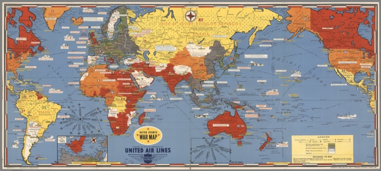


![Magyarorszag Légihelyzet Nyilvántartó Térképe [Air Situation Register Map of Hungary]](https://www.davidrumsey.com/rumsey/Size2/RUMSEY~8~1/199/15295000.jpg)


![India : (South part). [North part].](https://www.davidrumsey.com/rumsey/Size2/RUMSEY~8~1/199/14360195.jpg)

![Seat of War in Virginia, &c. : Sheet 2. [Sheet 1].](https://www.davidrumsey.com/rumsey/Size2/RUMSEY~8~1/199/14360255.jpg)