|
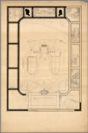
Author
Baker, Harriet E.
Full Title
(Title Page to) Harriet E. Baker's Book of Penmanship & Maps. At Mr. Dunham's School Windsor Vermont March 31, 1819.
List No
8307.002
Note
The existence of this book of penmanship throws interesting light on our other book of penmanship by Frances Henshaw, our 2501.000. This book by Harriet Baker is dated four years earlier, 1819, and from another school in Windsor, Vermont (Henshaw's school was in Middlebury, Vermont). Generally, the two books follow very similar structure, both the text and the maps, which would indicate that the production of these books of penmanship was more frequent than previously thought and also suggests that there was a common template used, even by different schools, in their construction. It can be said that Baker's maps are exquisite, perhaps a bit more so than Henshaw's, but Henshaw's text descriptions of the states are more elaborate than Baker's. For some reason, Baker omits maps of New York, Pennsylvania, South Carolina, Kentucky, Indiana, Illinois and Michigan, while including descriptions of most of them. Henshaw has no map or description of Michigan or Illinois. For the sources of the maps and text, see our entry for Henshaw's book, 2501.000. The Osher Map Library has a copy of another book of penmanship, also from Mr. Dunham's School in Windsor Vermont, titled “Catharine M. Cook’s Book of Penmanship at Mr. Dunham’s School, Windsor, Vermont, June 15th, 1818”
Author
Baker, Harriet E.
Full Title
(Description of) New Hampshire. (to accompany) Harriet E. Baker's Book of Penmanship & Map. At Mr. Dunham's School Windsor Vermont March 31, 1819.
List No
8307.019
Note
A short description of the state of New Hampshire. Hand lettered text.
Author
Baker, Harriet E.
Full Title
New Hampshire. (to accompany) Harriet E. Baker's Book of Penmanship & Map. At Mr. Dunham's School Windsor Vermont March 31, 1819.
List No
8307.020
Note
Outline color map by county. Showing cities and towns, and rivers.
Author
Baker, Harriet E.
Full Title
(Description of) Connecticut. (to accompany) Harriet E. Baker's Book of Penmanship & Map. At Mr. Dunham's School Windsor Vermont March 31, 1819.
List No
8307.025
Note
A short description of the state of Connecticut surrounded by vines. Hand lettered text.
Author
Baker, Harriet E.
Full Title
Connecticut. (to accompany) Harriet E. Baker's Book of Penmanship & Map. At Mr. Dunham's School Windsor Vermont March 31, 1819.
List No
8307.026
Note
Outline color map by county. Showing cities and towns, and rivers. Relief shown by hachures.
Author
Baker, Harriet E.
Full Title
(Description of) New Jersey. (to accompany) Harriet E. Baker's Book of Penmanship & Map. At Mr. Dunham's School Windsor Vermont March 31, 1819.
List No
8307.031
Note
A short description of the state of New jersey. Hand lettered text.
Author
Baker, Harriet E.
Full Title
New Jersey. (to accompany) Harriet E. Baker's Book of Penmanship & Map. At Mr. Dunham's School Windsor Vermont March 31, 1819.
List No
8307.032
Note
Outline color map by county, with decorative cartouche. Showing cities and towns, and rivers. Relief shown by hachures.
Author
Tripp, B. Ashburton, 1887-1955
Full Title
A Map of Castilla Del Oro Panama On the Spanish Main. B. Ashburton Tripp, Cleveland O, Des et Del. Copyright 1930 B.A.T.
List No
8642.000
Note
A hand drawn and colored pictorial map of Panama, one of Tripp's most elaborate and beautiful maps - for some reason, he never published this map, although he offered it for sale in 1931 at the annual May Show at the Cleveland Museum of Art, along with all rights of publication. Tripp had a special interest in Panama and his wife, Gertrude Koehne Tripp was a former school teacher in the Canal Zone. The map has many views of important places in Panama, portraits of explorers, and a ring of figures that are described as zoomorphic images of the Chiriqui Indian Deities, surrounding the map of the country.
Author
Tripp, B. Ashburton, 1887-1955
Full Title
Cape Cod : Barnstable County Massachusetts.
List No
8637.000
Note
An unfinished map drawing of Cape Cod that must have been an early state of Tripp's final Map of Cape Cod (see our 8636.000 and 8173.000). It is at a slightly larger scale than the final published map and shows many of the scenes sketched out and some parts unfinished. Shows towns, roads, railroad, and rivers. Bordered by illustrations of Cape Cod scenes.
Author
Tripp, B. Ashburton, 1887-1955
Full Title
The Mansion House Grounds of Mount Vernon The Estate of George Washington.
List No
8643.001
Note
Manuscript plan of Washington's house and grounds at Mount Vernon, bordered by scenes of the estate, profiles of George and Martha Washington, and quotes from Washington's correspondence. Tripp lived in Alexandria, Virginia, for part of his professional life, so visits to the estate may have inspired making the plan, or it might have been a professional assignment as part of his landscape design business. Date is estimated from this plan's inclusion in the 1932 May Show at the Cleveland Museum of Art.
Author
Tripp, B. Ashburton, 1887-1955
Full Title
(Sketch for) The Mansion House Grounds of Mount Vernon The Estate of George Washington.
List No
8643.002
Note
Unfinished sketch or study for Tripp's Plan of the Mansion House Grounds at Mount Vernon. Date is estimated from the finished plan's inclusion in the 1932 May Show at the Cleveland Museum of Art.
Author
Tripp, B. Ashburton, 1887-1955
Full Title
Cape Cod : Barnstable County Massachusetts.
List No
8644.000
Note
A completed map drawing of Cape Cod that must have been a study of sorts for of Tripp's final Map of Cape Cod (see our 8636.000 and 8173.000). It is at a slightly larger scale than the final published map. Like the unfinished drawing map (see our 8637.000), many of the views are only roughly sketched in. Shows towns, roads, railroad, and rivers. Bordered by illustrations of Cape Cod scenes.
Author
Tripp, B. Ashburton, 1887-1955
Full Title
The Italian Cultural Garden, Rockefeller Park, Cleveland. B. Ashburton Tripp Landscape Architect 1931.
List No
8645.000
Note
Manuscript plan of the Italian Cultural Garden in the Cleveland Cultural Gardens in Rockefeller Park. Tripp also designed the Hebrew Garden for Rockefeller Park (see our 8646.000). This plan was included in the 1931 May Show at the Cleveland Museum of Art.
Author
[Tripp, B. Ashburton, 1887-1955, Funk & Wagnalls Company.]
Full Title
The Hebrew Garden, Rockefeller Park, Cleveland. B. Ashburton Tripp Landscape Architect.
List No
8646.000
Note
Manuscript plan of the Hebrew Garden in the Cleveland Cultural Gardens in Rockefeller Park. Tripp also designed the Italian Cultural Garden for Rockefeller Park (see our 8645.000). This plan was included in the 1929 May Show at the Cleveland Museum of Art and the date is estimated from that event.
Author
Tripp, B. Ashburton, 1887-1955
Full Title
The Residence Grounds of Alfred L. Fritzsche, Shaker Heights. B. Ashburton Tripp Landscape Architect Cleveland.
List No
8647.000
Note
Manuscript plan of the gardens and landscape surrounding the house of Alfred L. Fritzsche in the Shaker Heights neighborhood of Cleveland. Fritzsche was a prominent Cleveland industrialist. This plan was included in the 1925 May Show at the Cleveland Museum of Art and is dated from that event.
Author
Tripp, B. Ashburton, 1887-1955
Full Title
Poinciana Island. Tropical Florida Development Corp'n. Owners and Developers. Fowler - Rood Co. inc. Sales Agents. 253 West Flagler Street, Miami Florida. B. Ashburton Tripp Landscape Architect and Town Planner, Cleveland. Scale: 1" = 100' December, 1825.
List No
8648.000
Note
Poinciana was a speculative real estate development on the Gulf Coast of Florida across the peninsula from Miami. Tripp created this town plan late in 1925, but the hurricane of 1926 wiped out Poinciana Island which was located at the mouth of Lostman River, now part of the Everglades National Park. This plan was included in the 1926 May Show at the Cleveland Museum of Art.
Author
[Great Britain. War Office, Stevens, Benjamin Franklin]
Full Title
(Composite of) B.F. Steven's Facsimile of the Unpublished British Head Quarters Coloured Manuscript map of New York & Environs, 1782, Reproduced from the original drawing in the War Office, London. Issued only to subscribers at 4, Trafalgar Square, W.C., London. 1900. Malby and Sons. Engravers.
List No
6403.004
Note
(Composite removing linen gaps between sections). From the printed advertisement for the map: "BF STEVENS'S Facsimile of the Unpublished British Headquarters Coloured Manuscript Map of New York and Environs 1782. Reproduced from the Original Drawing in the War Office London. 24 sheets Scale 6 1/2 inches to a mile. 10 feet by 4 feet. The successive British Commanders in Chief in America Generals Sir William Howe, Sir Henry Clinton, and Sir Guy Carleton during their respective occupations of New York and Environs in the Revolution caused this manuscript plan from time to time to be kept up. The plan extends from below Guanas Bay to the Heights of Spikendevi, a distance of about eighteen or nineteen miles. It shows the Fortifications, Defenses, Topography, Streets, Roads, etc. of the whole of the Island of New York with the Harbor Islands, Water Ways, and River Frontages on the Hudson and East Rivers, the Military Works on Long Island including Brooklyn, the Works in Paulus Hook and parts of the Jersey Shore. It has a copious Table of References to various works British and American, some of them with notes as to the time of their construction or destruction. The Original Drawing, ten feet by four feet, is on a scale of about six and a half inches to a mile. It is handsomely reproduced for subscribers only in careful facsimile on 24 sheets which can be joined up and mounted like the original as a Wall Map or mounted on linen if desired. It will be issued either mounted on linen to fold in book form with leather slip case 13 x 10 inches or the 24 sheets 22 x 15 inches, each will be supplied in a portfolio. No more than 100 copies are being printed and the engravings are erased as each sheet is printed off. A few extra copies of sheet 8 have been printed so that it can be sent as a specimen on application from intending subscribers..." <a href=http://www.davidrumsey.com/view/google-earth-browser#new-york-1782 target=_blank>View in Google Earth</a>
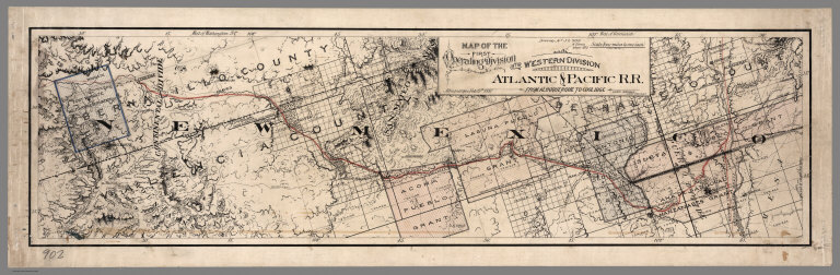
Author
Atlantic & Pacific Railroad
Full Title
Map of the First Operating Division of the Western Division, Atlantic & Pacific R.R., From Albuquerque to Coolidge. Drawing No. J2-902. Lewis Kingman, Chief Engineer.
List No
6929.001
Note
A set of six hand-drawn maps on semi-transparent waxed linen with some color. Some areas are colored on the verso to highlight the areas in a muted style. We think that some type of backlighting was planned to be used to create a photolithographic plate from which printing would be done. No evidence was found that it was ever printed. These sheets were deaccessioned from the Santa Fe Railroad collection in the 1980s. Lewis Kingman did the route survey from Albuquerque to Needles. Relief shown by hachures. This sheet has colored lines on the verso to add color to the various areas depicted on the recto.
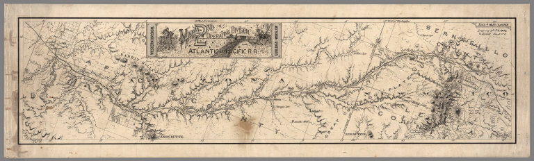
Author
Atlantic & Pacific Railroad
Full Title
Map of the 2nd Operating Division of the Western Division, Atlantic & Pacific R.R., From Coolidge to Winslow. Drawing No. J-2-902.
List No
6929.002
Note
Lavishly illustrated title block. No drawing on verso. A set of six hand-drawn maps on semi-transparent waxed linen with some color. Some areas are colored on the verso to highlight the areas in a muted style. We think that some type of backlighting was planned to be used to create a photolithographic plate from which printing would be done. No evidence was found that it was ever printed. These sheets were deaccessioned from the Santa Fe Railroad collection in the 1980s. Lewis Kingman did the route survey from Albuquerque to Needles. Relief shown by hachures.
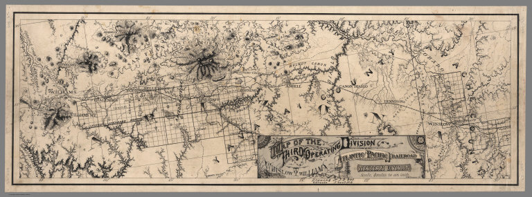
Author
Atlantic & Pacific Railroad
Full Title
Map of the Third Operating Division of the Western Division, Atlantic & Pacific R.R., From From Winslow to Williams. Drawing No. J-2-902.
List No
6929.003
Note
Drawing on verso behind title block. A set of six hand-drawn maps on semi-transparent waxed linen with some color. Some areas are colored on the verso to highlight the areas in a muted style. We think that some type of backlighting was planned to be used to create a photolithographic plate from which printing would be done. No evidence was found that it was ever printed. These sheets were deaccessioned from the Santa Fe Railroad collection in the 1980s. Lewis Kingman did the route survey from Albuquerque to Needles. Relief shown by hachures.
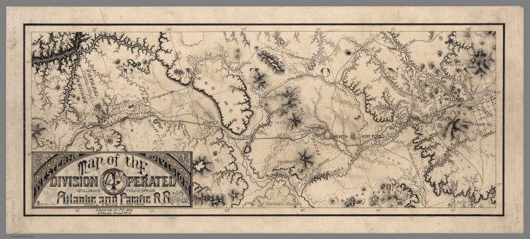
Author
Atlantic & Pacific Railroad
Full Title
Map of the 4th Operating Division of the Western Division, Atlantic & Pacific R.R., From Williams to Peach Springs. Drawing No. J-2-902.
List No
6929.004
Note
Drawing on verso behind title block. A set of six hand-drawn maps on semi-transparent waxed linen with some color. Some areas are colored on the verso to highlight the areas in a muted style. We think that some type of backlighting was planned to be used to create a photolithographic plate from which printing would be done. No evidence was found that it was ever printed. These sheets were deaccessioned from the Santa Fe Railroad collection in the 1980s. Lewis Kingman did the route survey from Albuquerque to Needles. Relief shown by hachures.
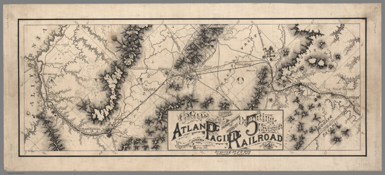
Author
Atlantic & Pacific Railroad
Full Title
Map of the 5th Operating Division of the Western Division, Atlantic & Pacific R.R., From Peach Springs to Needles. W.A. Drake, Acting Chief Engineer. Drawing No. J-2-902.
List No
6929.005
Note
No drawing on verso. A set of six hand-drawn maps on semi-transparent waxed linen with some color. Some areas are colored on the verso to highlight the areas in a muted style. We think that some type of backlighting was planned to be used to create a photolithographic plate from which printing would be done. No evidence was found that it was ever printed. These sheets were deaccessioned from the Santa Fe Railroad collection in the 1980s. Lewis Kingman did the route survey from Albuquerque to Needles. Relief shown by hachures.
Author
Atlantic & Pacific Railroad
Full Title
Map of the 6th Operating Division of the Western Division, Atlantic & Pacific R.R., From Needles to Mojave. Saml. M. Rowe, Resident Engineer. Drawing No. J-2-902.
List No
6929.006
Note
No drawing on verso. A set of six hand-drawn maps on semi-transparent waxed linen with some color. Some areas are colored on the verso to highlight the areas in a muted style. We think that some type of backlighting was planned to be used to create a photolithographic plate from which printing would be done. No evidence was found that it was ever printed. These sheets were deaccessioned from the Santa Fe Railroad collection in the 1980s. Lewis Kingman did the route survey from Albuquerque to Needles. Relief shown by hachures.
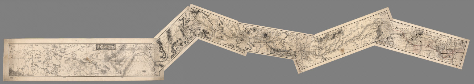
Author
Atlantic & Pacific Railroad
Full Title
(Composite of) Maps of the First through Sixth Operating Divisions of the Western Division, Atlantic & Pacific Railroad, Albuquerque, New Mexico, to Mojave (Mohave), California.
List No
6929.007
Note
Composite of all six maps joined together end to end. This is a set of six hand-drawn maps on semi-transparent waxed linen with some color. Some areas are colored on the verso to highlight the areas in a muted style. We think that some type of backlighting was planned to be used to create a photolithographic plate from which printing would be done. No evidence was found that it was ever printed. These sheets were deaccessioned from the Santa Fe Railroad collection in the 1980s. Lewis Kingman did the route survey from Albuquerque to Needles. Relief shown by hachures.
Author
Ordway, Eliza S.
Full Title
Map Of The United States. Eliza S. Ordway.
List No
2454.000
Note
Date is approximate, estimated by Howard Welsh. Probably a school project. With black top and bottom rollers. Without color.
Author
Lyon, Lucius, 1800-1851
Full Title
(Case to) (Michigan and Indiana Border Survey 1828-1835. Manuscript survey maps and notes)
List No
5125A
Note
The surveyor's copper canister or tube 8 cm. in diam. It is fitted with a buckle on the side and the remains of leather strap on a hinged lid which fed through the buckle; also 6 copper loops soldered to side of canister. The image also shows the roll of maps and notes contained therein.
Author
Lyon, Lucius, 1800-1851
Full Title
(Covers to) (Michigan and Indiana Border Survey 1828-1835. Manuscript survey maps and notes)
List No
5125B
Note
Sheepskin cover.
Author
Lyon, Lucius, 1800-1851
Full Title
(Index to) (Michigan and Indiana Border Survey 1828-1835. Manuscript survey maps and notes)
List No
5125C
Note
List of 32 township maps with survey dates, and magnetic declination in degrees and minutes east. Seven of the maps are contained in this work. Pen-and-ink.
Author
Lyon, Lucius, 1800-1851
Full Title
(Text Page to) (Michigan and Indiana Border Survey 1828-1835. Manuscript survey maps and notes)
List No
5125D
Note
Notes on interior corners of sections in Township 7 S., R. 10 W. Pen-and-ink.
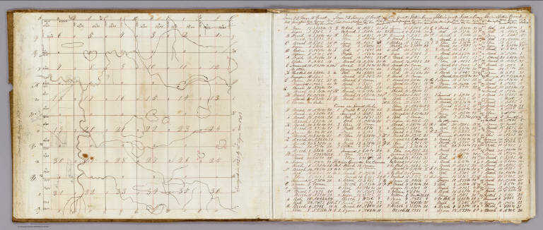
Author
Lyon, Lucius, 1800-1851
Full Title
Town 8 South, Range 20 West, Town 8 South, Range 19 West (Berrien County, Michigan, 1829)
List No
5125.001
Note
Colored manuscript map. Pen-and-ink. Shows sections, quarter sections, landowners, roads, hydrography, etc.
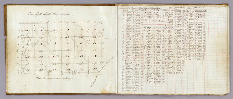
Author
Lyon, Lucius, 1800-1851
Full Title
Town 7 South, Rang[e] 19 West. Surveyed in 1829 by L. Lyon, varr. 5035' E.
List No
5125.002
Note
Colored manuscript map. Pen-and-ink and pencil. Shows sections, quarter sections, smaller parcels, landowners, roads, hydrography, etc. Located in Berrien County, Michigan. Facing the map is a table of courses and distances measuring 42 x 37 cm.
Author
Lyon, Lucius, 1800-1851
Full Title
Town 8 South, Range 19 West. (Surveyed in 1829 by L. Lyon)
List No
5125.003
Note
Colored manuscript map. Pen-and-ink and pencil. Shows sections, quarter sections, smaller parcels, landowners, roads, hydrography, etc. Located in Berrien County, Michigan on the "State line between Indiana & Michigan.". Facing the map is a table of courses and distances, 31 x 30 cm.
Author
Lyon, Lucius, 1800-1851
Full Title
Town 7 South, Range 20 West. (Surveyed in 1829 by L. Lyon). Road dists. in Chikaming Tp. in 1861 (added in pencil)
List No
5125.004
Note
Colored manuscript map. Pen-and-ink and pencil. Shows sections, quarter sections, smaller parcels, landowners, roads, hydrography, etc. Located in Berrien County, Michigan. Facing the map is a table of courses and distances, 32 x 37 cm.
Author
Lyon, Lucius, 1800-1851
Full Title
Town 8 South, Range 20 West. (Surveyed in 1829 by L. Lyon).
List No
5125.005
Note
Colored manuscript map. Pen-and-ink and pencil. Shows sections, quarter sections, landowners, hydrography, etc. Located in Berrien County, Michigan. Facing the map is a table of courses and distances, 31 x 31 cm.
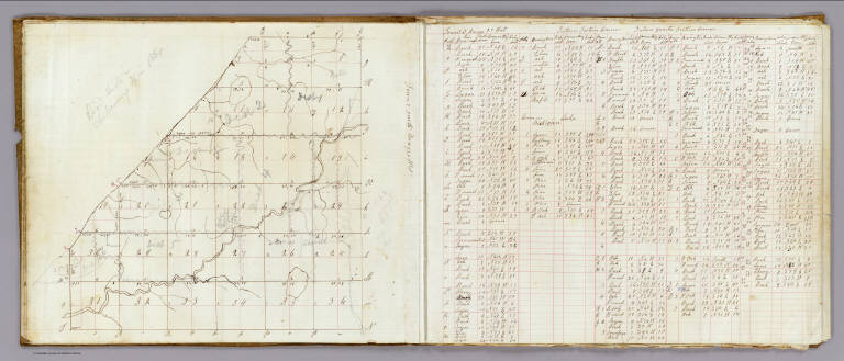
Author
Lyon, Lucius, 1800-1851
Full Title
T. 8 South, Range 21 West. (Surveyed in 1829 by L. Lyon).
List No
5125.006
Note
Colored manuscript map. Pen-and-ink and pencil. Shows sections, quarter sections, hydrography, "South Boundary of Michigan," etc. Located in Berrien County, Michigan. Facing the map is a table of courses and distances, 32 x 39 cm. Title from table.
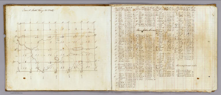
Author
Lyon, Lucius, 1800-1851
Full Title
T. 7 South, R. 21 West. T. 8 S., Range 22 W. (Surveyed in 1829 by L. Lyon).
List No
5125.007
Note
Two colored manuscript maps on 1 sheet. Pen-and-ink. Show sections, quarter sections, hydrography, etc. Located in Berrien County, Michigan. Includes table of courses and distances.
Author
Anonymous
Full Title
United States.
List No
5442.000
Note
Outline color hand drawn map by a young student. A silk blue border has been sown onto map with silk hooks for hanging. Date estimated from geography of the west.
Author
[Fitch, George W., Weeks, Lydia S.]
Full Title
Western Hemisphere ... Eastern Hemisphere drawn by (to be filled in. By George W. Fitch. New York: Sheldon, Blakeman and Company, 115 Nassau Street. Entered ... 1850, by Huntington and Savage ... New York)
List No
0289.001
Note
Printed map form with title, grid lines and numbers or "mapping plate." Two maps on 1 sheet. Map data added including relief by hachures in pen-and-ink by Lydia S. Weeks.
Author
[Fitch, George W., Weeks, Lydia S.]
Full Title
United States. Drawn by (to be filled in. By George W. Fitch. New York: Sheldon, Blakeman and Company, 115 Nassau Street. Entered ... 1850, by Huntington and Savage ... New York)
List No
0289.002
Note
Printed map form with title, grid lines and numbers or "mapping plate." Map data added including relief by hachures in pen-and-ink by Lydia S. Weeks. Prime meridians: Greenwich and Washington.
Author
[Budington, Sarah, Fitch, George W.]
Full Title
North America. Drawn by (to be filled in. By George W. Fitch. New York: Sheldon, Blakeman and Company, 115 Nassau Street. Entered ... 1850, by Huntington and Savage ... New York)
List No
0289.003
Note
Printed map form with title, grid lines and numbers or "mapping plate." Map data added including relief by hachures in pen-and-ink by Sarah Budington. Prime meridians: Greenwich and Washington.
Author
[Fitch, George W., Ufford, Fannie]
Full Title
State of (to be filled in). Drawn by (to be filled in. By George W. Fitch. New York: Sheldon, Blakeman and Company, 115 Nassau Street. Entered ... 1850, by Huntington and Savage ... New York)
List No
0289.004
Note
Printed map form with title and grid lines or "mapping plate." Map data added including title "New York," relief by hachures and coordinate values in pen-and-ink by Fannie Ufford(?)
Author
[Fitch, George W., Layfield, Frank H.]
Full Title
Mexico and Guatimala. Drawn by (to be filled in. By George W. Fitch. New York: Sheldon, Blakeman and Company, 115 Nassau Street. Entered ... 1850, by Huntington and Savage ... New York)
List No
0289.005
Note
Printed map form with title, grid lines and numbers or "mapping plate." Map data added including relief by hachures in pen-and-ink by Frank H. Layfield. Prime meridians: Greenwich and Washington.
Author
[Burritt, Emma, Fitch, George W.]
Full Title
South America. Drawn by (to be filled in. By George W. Fitch. New York: Sheldon, Blakeman and Company, 115 Nassau Street. Entered ... 1850, by Huntington and Savage ... New York)
List No
0289.006
Note
Printed map form with title, grid lines and numbers or "mapping plate." Map data added including relief by hachures in pen-and-ink by Emma Burritt Prime meridians: Greenwich and Washington.
Author
[Fitch, George W., Jamison, Joseph]
Full Title
Europe. Drawn by (to be filled in. By George W. Fitch. New York: Sheldon, Blakeman and Company, 115 Nassau Street. Entered ... 1850, by Huntington and Savage ... New York)
List No
0289.007
Note
Printed map form with title, grid lines and numbers or "mapping plate." Map data added including relief by hachures in pen-and-ink by Joseph Jamison. Prime meridians: Washington and Greenwich and Washington.
Author
Fitch, George W.
Full Title
Southern Europe. Drawn by (to be filled in. By George W. Fitch. New York: Sheldon, Blakeman and Company, 115 Nassau Street. Entered ... 1850, by Huntington and Savage ... New York)
List No
0289.008
Note
Printed map form with title, grid lines and numbers or "mapping plate." Drawn by (in pencil) M.E.H. Brooks. Mapping has not been added. Prime meridians: Washington and Greenwich.
Author
[Fairchild, Lucy, Fitch, George W.]
Full Title
British Islands. Drawn by (to be filled in. By George W. Fitch. New York: Sheldon, Blakeman and Company, 115 Nassau Street. Entered ... 1850, by Huntington and Savage ... New York)
List No
0289.009
Note
Printed map form with title, grid lines and numbers or "mapping plate." Map data added including relief by hachures in pen-and-ink by Lucy Fairchild.
Author
[Fitch, George W., Lampson, Mary E.]
Full Title
Germany. Drawn by (to be filled in. By George W. Fitch. New York: Sheldon, Blakeman and Company, 115 Nassau Street. Entered ... 1850, by Huntington and Savage ... New York)
List No
0289.010
Note
Printed map form with title, grid lines and numbers or "mapping plate." Map data added including relief by hachures in pen-and-ink by Mary E. Lampson. Prime meridians: Greenwich and Washington.
Author
[Fairchild, Lucy, Fitch, George W.]
Full Title
Africa. Drawn by (to be filled in. By George W. Fitch. New York: Sheldon, Blakeman and Company, 115 Nassau Street. Entered ... 1850, by Huntington and Savage ... New York)
List No
0289.011
Note
Printed map form with title, grid lines and numbers or "mapping plate." Map data added including relief by hachures in pen-and-ink by Lucy Fairchild. Prime meridians: Greenwich and Washington.
Author
[Fitch, George W., Lampson, Mary E.]
Full Title
Asia. Drawn by (to be filled in. By George W. Fitch. New York: Sheldon, Blakeman and Company, 115 Nassau Street. Entered ... 1850, by Huntington and Savage ... New York)
List No
0289.012
Note
Printed map form with title, grid lines and numbers or "mapping plate." Map data added including relief by hachures in pen-and-ink by Mary E. Lampson. Prime meridians: Greenwich and Washington.
Author
Pirî Reis, d. 1554?
Full Title
fol. 4b Incipit page with illuminated headpiece
List No
10108.015
Note
Author's name given on fol. 376b as Raʾīs al-Baḥr Pīrī ibn Muḥammad; author dates preferred by (Walters) cataloger: d. 962 AH / 1555 CE
|