|
Author
Kohnke Printing Co.
Full Title
Map of the city and county of San Francisco : from the latest certified data. Copyright by Kohnke Printing Co., 1936. (inset) Map showing boundaries of the city and co. of San Francisco ...
List No
11495.000
Note
Plan of the city and county of San Francisco. Shows county boundaries, city blocks, streets, municipal railways, bus lines, public buildings, landmarks and parks. Relief shown pictorially. Includes legend and compass rose oriented with the north to upper left margin.
Author
[Bennett, Edward H., Burnham, Daniel Hudson, 1846-1912]
Full Title
(Covers to) Report on a plan for San Francisco by Daniel H. Burnham. Assisted by Edward H. Bennett. Presented to the Mayor and Board of Supervisors by the Association for the Improvement and Adornment of San Francisco. Edited by Edward F. O'Day. September, MCMV. Published by the City.
List No
1625A
Note
Maroon cloth covers with title in gilt: Report of D.H. Burnham on the improvement and adornment of San Francisco. Spine title: Report of D.H. Burnham on a plan for San Francisco.
Author
[Bennett, Edward H., Burnham, Daniel Hudson, 1846-1912]
Full Title
(Title Page to) Report on a plan for San Francisco by Daniel H. Burnham. Assisted by Edward H. Bennett. Presented to the Mayor and Board of Supervisors by the Association for the Improvement and Adornment of San Francisco. Edited by Edward F. O'Day. September, MCMV. Published by the City. (verso: engraved and printed by Sunset Press, San Francisco)
List No
1625B
Author
[Bennett, Edward H., Burnham, Daniel Hudson, 1846-1912]
Full Title
(Contents to) Report on a plan for San Francisco by Daniel H. Burnham. Assisted by Edward H. Bennett. Presented to the Mayor and Board of Supervisors by the Association for the Improvement and Adornment of San Francisco. Edited by Edward F. O'Day. September, MCMV. Published by the City.
List No
1625C
Note
Table of contents and verso of title page reading "Engraved and printed by Sunset Press, San Francisco."
Author
[Bennett, Edward H., Burnham, Daniel Hudson, 1846-1912]
Full Title
(Contents to) Report on a plan for San Francisco by Daniel H. Burnham. Assisted by Edward H. Bennett. Presented to the Mayor and Board of Supervisors by the Association for the Improvement and Adornment of San Francisco. Edited by Edward F. O'Day. September, MCMV. Published by the City.
List No
1625D
Note
Table of contents (continued), List of illustrations and List of maps and plans.
Author
[Bennett, Edward H., Burnham, Daniel Hudson, 1846-1912, Meryon, Charles]
Full Title
(Preface to) Report on a plan for San Francisco by Daniel H. Burnham. Assisted by Edward H. Bennett. Presented to the Mayor and Board of Supervisors by the Association for the Improvement and Adornment of San Francisco. Edited by Edward F. O'Day. September, MCMV. Published by the City.
List No
1625E
Note
First page of preface. Small "Etching by Meryon, 1855" at top of sheet.
Author
[Bennett, Edward H., Burnham, Daniel Hudson, 1846-1912]
Full Title
(Preface to) Report on a plan for San Francisco by Daniel H. Burnham. Assisted by Edward H. Bennett. Presented to the Mayor and Board of Supervisors by the Association for the Improvement and Adornment of San Francisco. Edited by Edward F. O'Day. September, MCMV. Published by the City.
List No
1625F
Note
Last page of preface.
Author
[Bennett, Edward H., Burnham, Daniel Hudson, 1846-1912]
Full Title
Bird's-eye perspective of the City from Twin Peaks, showing the proposed changes. (By Daniel H. Burnham. Assisted by Edward H. Bennett. 1905)
List No
1625.005
Note
Photographic reproduction of map.
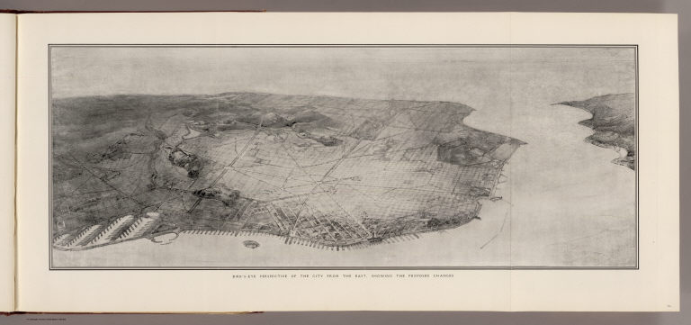
Author
[Bennett, Edward H., Burnham, Daniel Hudson, 1846-1912]
Full Title
Bird's-eye perspective of the City from the east, showing the proposed changes. (By Daniel H. Burnham. Assisted by Edward H. Bennett. 1905)
List No
1625.006
Note
Photographic reproduction of map.
Author
[Bennett, Edward H., Burnham, Daniel Hudson, 1846-1912]
Full Title
Plan of Civic Center. (By Daniel H. Burnham. Assisted by Edward H. Bennett. 1905)
List No
1625.023
Note
Uncolored map.
Author
[Bennett, Edward H., Burnham, Daniel Hudson, 1846-1912]
Full Title
View of Civic Center, looking from the south side of Market Street. (By Daniel H. Burnham. Assisted by Edward H. Bennett. 1905)
List No
1625.024
Note
Uncolored bird's-eye view showing buildings, column, streets, etc.
Author
[Bennett, Edward H., Burnham, Daniel Hudson, 1846-1912]
Full Title
Typical plan of playground north of Washington Square. (By Daniel H. Burnham. Assisted by Edward H. Bennett. 1905)
List No
1625.025
Note
Uncolored map showing Washington Square with trees and walkways and adjacent plot to north surrounded by Stockton, Filbert, Powell and Lombard streets showing ball field, gymnasia and field house. Oriented with north toward bottom.
Author
[Bennett, Edward H., Burnham, Daniel Hudson, 1846-1912]
Full Title
Telegraph Hill, looking east, showing suggested architectural treatment. (By Daniel H. Burnham. Assisted by Edward H. Bennett. 1905)
List No
1625.038
Note
Photographic reproduction of drawing.
Author
[Bennett, Edward H., Burnham, Daniel Hudson, 1846-1912]
Full Title
View of the proposed drill ground from the heights, looking northeast (San Francisco Presidio. By Daniel H. Burnham. Assisted by Edward H. Bennett. 1905)
List No
1625.039
Note
Photographic reproduction of drawing.
Author
[Bennett, Edward H., Burnham, Daniel Hudson, 1846-1912]
Full Title
Approach to Twin Peaks as seen from Market Street. (By Daniel H. Burnham. Assisted by Edward H. Bennett. 1905)
List No
1625.040
Note
Photographic reproduction of drawing.
Author
[Bennett, Edward H., Burnham, Daniel Hudson, 1846-1912]
Full Title
Map of the city and county of San Francisco showing areas recommended as necessary for public places, parks, park connections and highways. Report of D.H. Burnham, Sept. 1905.
List No
1625.046
Note
Colored map. Relief shown by contours.
Author
[Bennett, Edward H., Burnham, Daniel Hudson, 1846-1912]
Full Title
San Francisco plan, showing system of highways, public places, parks, park connections, etc. to serve as a guide for the future development of the city recommended in his Report to the Association for the Improvement and Adornment of San Francisco by D.H. Burnham. September MCMV.
List No
1625.047
Note
Lithographed map. Relief shown by contours (interval: 20 ft.) and hachures.
Author
[Bennett, Edward H., Burnham, Daniel Hudson, 1846-1912]
Full Title
Map showing San Francisco wate-front in early days.
List No
1625.048
Note
Lithographed map. Relief shown by contours (interval: 20 ft.) and hachures.
Author
[Bennett, Edward H., Burnham, Daniel Hudson, 1846-1912]
Full Title
Mission Plank Road, Southwest fron Ninth, 1856
List No
1625.049
Author
Del Monte Properties Company
Full Title
Map of Pacific Grove Properties Showing Lots which will be sold at Absolute Auction Sale. Commencing on Thursday, November 6th ... (on verso) Advertisements and views around Pacific Grove.
List No
3337.001
Note
Classic real estate promotional broadside. Map is printed with the lots to be sold shown in red. There is a note on map reading "Remember!! A man can borrow one on what he puts into a home. He can't on what he pays out for rent."
Author
Del Monte Properties Company
Full Title
(Text Page to) Map of Pacific Grove Properties Showing Lots which will be sold at Absolute Auction Sale. Commencing on Thursday, November 6th ... (on verso) Advertisements and views around Pacific Grove.
List No
3337.002
Note
Lower half, text, advertisement and views of pacific Grove and surrounding areas. On verso: Classic real estate promotional broadside. Map is printed with the lots to be sold shown in red. There is a note on map reading "Remember!! A man can borrow one on what he puts into a home. He can't on what he pays out for rent."
Author
Del Monte Properties Company
Full Title
(Text Page to) Map of Pacific Grove Properties Showing Lots which will be sold at Absolute Auction Sale. Commencing on Thursday, November 6th ... (on verso) Advertisements and views around Pacific Grove.
List No
3337.003
Note
Upper half, text, advertisement and views of pacific Grove and surrounding areas. On verso: Classic real estate promotional broadside. Map is printed with the lots to be sold shown in red. There is a note on map reading "Remember A man can borrow one on what he puts into a home. He can't on what he pays out for rent."
Author
[Reece, C. W., Tucker, E.]
Full Title
Map of the Pleasant Valley Tract at Oroville, Butte Co., Cal. ... Containing about 600 acres. For sale in subdivision by E. Tucker, Oroville. Surveyed by C.W. Reece, C.E. December, 1887. Lith. Dakin Pub. Co. S.F. Cal. (inset) Map showing relative location of Pleasant Valley Tract to City of Oroville, Cal.
List No
3338.001
Note
Full color map of the tract for sale. Shows lot numbers and size, irrigation ditches, ranch buildings, etc. Bird's-eye view on verso and text on verso.
Author
[Reece, C. W., Tucker, E.]
Full Title
View of Pleasant Valley Tract and City of Oroville, Cal. Lith. Dakin Pub. Co., S.F., Cal. (folded title) The Pleasant Valley Tract in the Butte County citrus belt, one-half mile from Oroville, Cal. For sale by E. Tucker, Oroville, Cal. (1887)
List No
3338.002
Note
Lithographed birds-eye view. Includes text and climate data. On verso: Map of the Pleasant Valley Tract ...
Full Title
El Rancho Cotati, Sonoma Co., Cal. (Published by Reynolds & Proctor, Santa Rosa, Cal., 1898)
List No
3341.103
Note
Two photographic illustrations and map: A glimpse of rolling land and valley, Rancho Cotati -- Bird's-eye view of the Rancho Cotati -- A glimpse of the valley, Rancho Cotati. Bird's-eye view has title "Rancho Cotati" and includes inset "Plat of the town site of Cotati." Includes text. Running title: Sonoma County homes and industries. U.S. Geological Survey's Geographic Names Information System spells the rancho Cotate.
Author
Allardt, G. F.
Full Title
Map no. 3. Salt marsh and tide lands situate in the city and county of San Francisco. To be sold at public auction by order of the Board of Tide Land Commissioners by Talbert & Leet, auctioneers, at their sales rooms no. 526 California Street, San Francisco. Sale to commence Friday Nov. 26th, 1869. B.F. Washington, H.P. Coon, L.L Bullock, Wm. S. Byrne, Secretary, Tide Land Commissioners. G.F. Allardt, Surveyor & Chief Engineer. C.H. Baker Lith., S.F.
List No
3970.000
Note
Cadastral map showing drainage, block and lot numbers, railroads, wharves, etc. Covers area from China Basin to Islais Creek. One of a series of maps published between 1869 and 1873 showing tidelands to be sold by order of the Board of Tide Land Commissioners.
Author
Allardt, G. F.
Full Title
Sale map no. 12. Salt marsh and tide lands situate in the city and county of San Francisco, state of California. To be sold at public auction by order of the Board of Tide Land Commissioners ... at the sales rooms of Greenebaum & Co., auctioneers, nos. 115 & 117 Bush Street, San Francisco. Sale to commence Tuesday, March 4th, 1873. R.P. Johnson, Edgar Briggs, C.M. Stratton, Board of Tide Land Commissioners. J.M. Currier, Secretary. G.F. Allardt, Chief Engineer.
List No
3971.000
Note
Another tide lands sale map, this one showing two separate areas titled "Salt Marsh and Tide Lands at North Beach" and "Salt Marsh and Tide Lands Along Mission Creek and Mission Bay." Shows drainage, block and lot numbers, etc. Covers area bounded generally by Mission, 20th, Mississippi, and Channel Streets; covers area bounded by the Bay, Webster and Lombard Streets, and the Presidio. Cadastral maps. Scale of 2nd map 1:6,000.
Author
[Honey Lake Valley Land and Water Company, Taylor, L. H. (Leon Henry), b. 1863]
Full Title
Plate No.4 showing reservoir, canals and ditches : [Honey Lake Valley, Calif.] Honey Lake Valley Land and Water Company. Office: Room 6, Flood Building, San Francisco, Cal. L.H. Taylor, Engineer-in-Chief. (1891?)
List No
4657.000
Note
Uncolored lithographed cadastral map showing sections, drainage, canals, etc. Located on the California/Nevada border. David Rumsey Collection copy in capsule with: Bird's eye view of Honey Lake Valley ... (1891?)
Author
Richardson, George L.
Full Title
Map Of The Murray Tract Subdivision One, Marin County Cal. 1912. I, Geo. L. Richardson County Surveyor of Marin County, California, do hereby certify, that at the requet of the owners, I have surveyed, the tract of land known as the Murray Tract in Marin County and have prepared a true and accurate map ... 8th day of July A.D. 1912 Geo L. Richardson, Surveyor of Marin County, California.
List No
4773.000
Note
A fairly typical subdivision map, except for the inclusion of two photographic views of the raw land which is to become the finished tract. The only example we have seen of this approach. Without color.
Author
[Britton & Co., Hoadley, Milo]
Full Title
Map of the Beideman Tract lots & blocks according to official map of the Western Addition. Drawn from actual survey by M. Hoadley. ... Lith. Britton & Co. To be sold at public auction, on Saturday, Oct. 6th, 1860 at 12 o'clock M. at Platts Music Hall. By H.A. Cobb and R.H. Sinton, real estate auctrs. (with) Map of the city of San Francisco. Published by Britton & Co., Lithographers, Montgomery St. cor. of Comml. sts., San Francisco.
List No
4780.000
Note
Scarce and early land sale map with a very early issue of Britton & Co.'s "Map of the City of San Francisco" and below it on the same sheet a larger "Map of the Beideman Tract..." Beideman owned several large parcels of land in the emerging areas of the city and this tract was one of the earliest to be sold in the newly annexed Western Addition. The Britton & Co. Map of San Francisco is the earliest issue that we have seen, followed by several issues in 1863 to 1867 by Gensoul and the San Francisco Municipal Reports and the San Francisco Directory (see our copies under Gensoul). The Norris catalog lists an 1859 Map of Hayes Tract also by M. Hoadley with lots to be sold at auction by H.A. Cobb, but the San Francisco map is not printed above the Hayes Tract map. One of the earliest San Francisco land sales maps. Covers area bounded by Laguna, Bush, Larkin and McAllister streets. Casastral map.
Author
Allardt, G. F.
Full Title
Sale map no. 8 of salt marsh and tide lands situate in the county of Marin, state of California. To be sold at public auction by order of the Board of Tide Land Commissioners ... John Middleton, auctioneer. Sale to commence Tuesday, July 18th 1871 at Platt's Hall, San Francisco. B.F. Washington, Rodmond Gibbons, L.L. Bullock, Board of Tide Land Commissioners. Wm. S. Byrne, Secretary. G.F. Allardt, Chief Engineer. F.C. Hafenrichter, draughtsman. G.T. Brown & Co. Lith. 540 Clay St. S.F.
List No
4783.000
Note
Sale maps of state tide lands in Marin are more scarce than those of San Francisco or the East Bay. Shows San Rafael and San Quentin and the railroad connecting them. Covers area from Corte Madera Canal (south of San Quentin) to Gallinas Canal. Grafton T. Brown was the first African American lithographer in San Francisco. Relief shown by hachures. Shows drainage, township and section lines, lot numbers, land ownership, ranchos, etc.
Author
South San Francisco Land & Improvement Co.
Full Title
South San Francisco Issued By The South San Francisco Land & Improvement Co. San Francisco, Cal. Plat Of South San Francisco. Rand, McNally & Co., Engravers, Chicago. Earnshaw & Punshon, Surveyors and Landscape Engineers, Cincinnati, Ohio.
List No
5293.000
Note
An early South San Francisco land promotion map. Very well executed. With full printed color. Date estimated.
Author
New Richmond Land Company
Full Title
Map of Richmond, California. New Richmond Land Company, 801-803 Monadnock Building, San Francisco. Wall's Harbor Center Tract, The Value Center. Bolte & Braden Company, San Francisco.
List No
5312.000
Note
A real estate development map, showing lot numbers. Date is estimated. Map shows the Wall's Harbor Center Tract in red, and the City Hall Site and Civic Center in green.
Author
[McClure, W. F. (Wilbur F.), Patterson, Smith & Co.]
Full Title
Map of Berkeley, California. W.F. McClure, City Engineer. Patterson, Smith & Co., Inc., successors to R.R. Patterson, Real Estate and Insurance, 2107 University Avenue ... General agents for Claremont Heights Tract. (1910?)
List No
5317.001
Note
Shows tracts, block numbers, ward boundaries and major land owners, etc. Includes street index. Map on verso: Claremont Heights Subdivision No. 1.
Author
[McClure, W. F. (Wilbur F.), Patterson, Smith & Co.]
Full Title
Claremont Heights Subdivision No. 1. Choice Berkeley villa sites. W.F. McClure, City Engineer of Berkeley. Patterson, Smith & Co., Inc., 2107 University Avenue, Berkeley, Cal. (1910?)
List No
5317.002
Note
Cadastral map showing lot numbers and dimenstions, streets, sewer lines, etc. On verso of: Map of Berkeley.
Author
Honey Lake Valley Land and Water Company
Full Title
Bird's eye view of Honey Lake Valley. Lassen County California. Honey Lake Valley Land & Water Co. Room 6 Flood Building. San Francisco. (1891?)
List No
5641.000
Note
Uncolored lithographed cadastral map showing sections, drainage, canals, etc. Located on the California/Nevada border. David Rumsey Collection copy in capsule with: Plate No.4 showing reservoir, canals and ditches ... (1891?)
Author
[San Diego Land and Town Company, W.W. Elliott & Co.]
Full Title
(Covers to) Guide to San Diego Bay Region, California containing reliable and valuable information concerning the products and prospects of the country. A bird's eye view of National City, San Diego, and surrounding country and especially showing the advantages of property now offered for sale by the San Diego Land & Town Co. ... Record Print, National City, Cal. (1887?)
List No
5674A
Note
Folded covers, printed in black and red. On sheet with 14 p. text. On verso Birds-eye view of National City, San Diego County, California.
Author
[San Diego Land and Town Company, W.W. Elliott & Co.]
Full Title
(Text Page to) Guide to San Diego Bay Region, California containing reliable and valuable information concerning the products and prospects of the country. A bird's eye view of National City, San Diego, and surrounding country and especially showing the advantages of property now offered for sale by the San Diego Land & Town Co. ... Record Print, National City, Cal. (1887?)
List No
5674B
Note
16 p. text including folding cover. On verso Birds-eye view of National City, San Diego County, California.
Author
[San Diego Land and Town Company, W.W. Elliott & Co.]
Full Title
Birds-eye view of National City, San Diego County, California. W.W. Elliott Lith., S.F. Published by Frank P. Burgess and Co., proprietors of National City Record. (1887?)
List No
5674.001
Note
Lithograph. View looking west from Old San Diego to Mexican border. Includes 17 small views: Office of J.A. Rice -- St. Matthew's Episcopal Church -- Kimball Block -- G.W. Chase Block -- San Diego Land & Town Co.'s office, National City -- (National City Planing Mill) W.E. Kimball, proprietor -- Olive works of F.A. Kimball, 8th Avenue -- International Hotel, W.H. Porter, prop. -- (Wm. Burgess Real Estate), Conveyancing & insurance -- Residence of J.C. Hussey -- Res. of Mr. & Mrs. O.E.M. Howard -- Residence of W.C. Kimball -- Residence of Frank A. Kimball -- Residence of T. Parsons -- Residence & real estate office of Geo. W. Roberts -- National City Public School -- Record Steam Printing House. Includes key and text. 16 p. text on verso with title: Guide to San Diego Bay Region, California ...
Author
Smith, Joseph, draftsman
Full Title
Map of Berkeley. Published by Carnall & Eyre, dealers in Berkeley Real Estate. Compiled by Joseph Smith, Oakland. From the records of Alameda Co., Cal. Lith. A. Waldstein, S.F. (1880)
List No
5724.000
Note
Hand col. Relief shown by hachures. Shows drainage, tracts, land ownership, railroads, etc. Includes regional map. Oriented with north toward upper right.
Author
[King, M. G. (Malcolm G.), William J. Dingee]
Full Title
Map of Oakland, Berkeley and Alameda. William J. Dingee, agent. For the purchase, sale, appraisal and care of real estate. 460 & 462 Eighth Street near Broadway, Oakland. M.G. King, C.E., surveyor. Entered ... in the year 1878, by Woodward & Taggart in the office of the Librarian of Congress at Washington, D.C. Galloway Litho Co., 418-422 Commercial St., S.F. (1884?)
List No
5725.001
Note
Uncolored lithographic map. Shows drainage, block numbers, ownership of large parcels, railroads, charter line, Oakland Harbor improvements, etc. Includes location map. Covers also Emeryville, Piedmont and Albany. Oriented with north toward left. Jackson, Vandercook & Melvin advertisement on verso. David Rumsey Collection copy: has annotations in black and col. pencil.
Author
[King, M. G. (Malcolm G.), William J. Dingee]
Full Title
W.F. Melvin, E.F. Vandercook, R.D. Jackson. Jackson, Vandercook & Melvin, successors to C.W. McLaughlin & Co. Real estate and insurance agents, 458 Ninth Street. Telephone No. 285. Oakland, Cal. (1884?)
List No
5725A
Note
Lithographed advertisement. On verso of: Map of Oakland, Berkeley and Alameda.
Author
Rumble, A. C.
Full Title
(Covers to) Second grand excursion to, and monster auction sale of lots and blocks in Park Place, a subdivision of the famous Laundry Farm, By Bovee, Toy & Co., on Saturday, September 8th, 1888. (to accompany) Map showing A Portion Of Park Place, Formerly Known As "Laundry Farm" Adjoining Mills Seminary On The Line Of The Alameda County Railway : Alameda County, Cal. Scale 200'=1". Surveyed July, 1888 A.C. Rumble, C.E. Lith. Britton & Rey, S.F. Shaded Lots are Sold. (map on verso) Relative Position of Park Place, Laundry Farm With Oakland & Vicinity. Britton & Rey Lith. S.F.
List No
5919.001
Note
Uncolored cadastral map, folded into 36x27. With cover title "Second grand excursion to, and monster auction sale of lots and blocks in Park Place, a subdivision of the famous Laundry Farm, By Bovee, Toy & Co., on Saturday, September 8th, 1888. Includes text and advertisement on recto". Map shows block and lot numbers, measurements, and railroads. Lots sold are shaded and hand written. Relief shown by hachures.
Author
Rumble, A. C.
Full Title
Relative Position of Park Place, Laundry Farm With Oakland & Vicinity. Britton & Rey Lith. S.F. (on verso) Map showing A Portion Of Park Place, Formerly Known As "Laundry Farm" Adjoining Mills Seminary On The Line Of The Alameda County Railway : Alameda County, Cal. Scale 200'=1". Surveyed July, 1888 A.C. Rumble, C.E. Lith. Britton & Rey, S.F. Shaded Lots are Sold.
List No
5919.002
Note
Uncolored cadastral map, folded into 36x27. With cover title "Second grand excursion to, and monster auction sale of lots and blocks in Park Place, a subdivision of the famous Laundry Farm, By Bovee, Toy & Co., on Saturday, September 8th, 1888. Includes text and advertisement on recto". Map shows block and lot numbers, measurements, and railroads. Lots sold are shaded and hand written. Relief shown by hachures.
Author
Rumble, A. C.
Full Title
Map showing A Portion Of Park Place, Formerly Known As "Laundry Farm" Adjoining Mills Seminary On The Line Of The Alameda County Railway : Alameda County, Cal. Scale 200'=1". Surveyed July, 1888 A.C. Rumble, C.E. Lith. Britton & Rey, S.F. Shaded Lots are Sold. (map on verso) Relative Position of Park Place, Laundry Farm With Oakland & Vicinity. Britton & Rey Lith. S.F.
List No
5919.003
Note
Uncolored cadastral map, folded into 36x27. With cover title "Second grand excursion to, and monster auction sale of lots and blocks in Park Place, a subdivision of the famous Laundry Farm, By Bovee, Toy & Co., on Saturday, September 8th, 1888. Includes text and advertisement on recto". Map shows block and lot numbers, measurements, and railroads. Lots sold are shaded and hand written. Relief shown by hachures.
Author
Snyder & Gillis
Full Title
(Covers to) Free carriage to and from the tract. Map of the Roberts and Wolfskill Tract... To be sold at private sale at the office of Snyder & Gillis ... Cubery & Co., Electric Power Printers, S.F. (to accompany) Roberts & Wolfskill Tract. The Roberts And Wolfskill Tract, For Sale By Snyder & Gillis, 467 Ninth Street, Oakland, Cal. Cubery & co., Electric Power Printers, 415 Market St. S.F. (on verso) Location map, and (inset map) San Francisco.
List No
5923.001
Note
Color cadastral map, folded to 36x27. Date estimated. Shows block, lots with numbers, measurements, and railroad tract. Covers area in Claremont, between Berkeley and Oakland, by Alcatraz Avenue, Racine, Maple and Colby Streets. Cover title: "Free carriage to and from the tract. Map of the Roberts and Wolfskill Tract... To be sold at private sale at the office of Snyder & Gillis... Cubery & Co., Electric Power Printers, S.F. Advertisement on verso.
Author
Snyder & Gillis
Full Title
(Advertisement to) ) Roberts & Wolfskill Tract. The Roberts And Wolfskill Tract, For Sale By Snyder & Gillis, 467 Ninth Street, Oakland, Cal. Cubery & co., Electric Power Printers, 415 Market St. S.F. (on verso) Location map, and (inset map) San Francisco.
List No
5923.002
Note
Color cadastral map, folded to 36x27. Date estimated. Shows block, lots with numbers, measurements, and railroad tract. Covers area in Claremont, between Berkeley and Oakland, by Alcatraz Avenue, Racine, Maple and Colby Streets. Cover title: "Free carriage to and from the tract. Map of the Roberts and Wolfskill Tract... To be sold at private sale at the office of Snyder & Gillis ... Cubery & Co., Electric Power Printers, S.F. Advertisement on verso.
Author
Snyder & Gillis
Full Title
Roberts & Wolfskill Tract. The Roberts And Wolfskill Tract, For Sale By Snyder & Gillis, 467 Ninth Street, Oakland, Cal. Cubery & co., Electric Power Printers, 415 Market St. S.F. (on verso) Location map, and (inset map) San Francisco.
List No
5923.003
Note
Color cadastral map, folded to 36x27. Date estimated. Shows block, lots with numbers, measurements, and railroad tract. Covers area in Claremont, between Berkeley and Oakland, by Alcatraz Avenue, Racine, Maple and Colby Streets. Cover title: "Free carriage to and from the tract. Map of the Roberts and Wolfskill Tract... To be sold at private sale at the office of Snyder & Gillis... Cubery & Co., Electric Power Printers, S.F. Advertisement on verso.
Author
Snyder & Gillis
Full Title
(Untitled map of) Roberts & Wolfskill Tract. (untitled inset map) San Francisco. (on verso) Roberts & Wolfskill Tract. The Roberts And Wolfskill Tract, For Sale By Snyder & Gillis, 467 Ninth Street, Oakland, Cal. Cubery & co., Electric Power Printers, 415 Market St. S.F.
List No
5923.004
Note
Uncolored map of Claremont between Berkeley and Oakland, showing location map, with inset map of San Francisco. Advertisement on verso.
Author
[Thurston, Albert G., Rock, Geo H.]
Full Title
Imperial Valley tract map. Published by Western Map & Publishing Co. El Centro and Pasadena. Copyright 1914 by Albert G. Thurston ; drawn by Geo. H. Rock.
List No
6750.001
Note
Printed on gold colored map. Showing boundaries, townships, range, sections, tracts, some ownership districts, roads, railroads. Includes legend and advertisement. Relief shown by hachures and spot heights.
|