|
Author
News Map of the Week, Inc.
Full Title
World News of the Week : Monday, Apr. 10, 1944. Covering period Mar. 31 to Apr. 6. Volume 6, No. 32. Published and copyrighted (weekly), 1944, by News Map of the Week, Inc., 1512 Orleans Street, Chicago, Illinois. Published in two sections : Section one. Lithographed in U. S. A.
List No
14167.000
Note
Lithographed world map, in color. Shows political boundaries and military events of World War II, from March 31 to April 6, 1944. Relief illustrated with hachures. Includes a key indicating the alignment of warring nations (United, Axis, and neutral). Descriptive text throughout, e.g.: Budapest bombed by Allied planes. Map indexed according to historical notes beneath map. Features photographs, illustrations, and international time zones. With two inset maps: Reference chart for Pan-American Day, April 14, 1944 -- The Russian battlefront. Map is 56 x 115 cm, on sheet 89 x 120 cm, folded to 31 x 23 cm.
Author
News Map of the Week, Inc.
Full Title
World News of the Week : Monday, Apr. 24, 1944. Covering period Apr. 14 to Apr. 20. Volume 6, No. 34. Published and copyrighted (weekly), 1944, by News Map of the Week, Inc., 1512 Orleans Street, Chicago, Illinois. Published in two sections : Section one. Lithographed in U. S. A.
List No
14168.000
Note
Lithographed world map, in color. Shows political boundaries and military events of World War II, from April 14 to 20, 1944. Relief illustrated with hachures. Descriptive text throughout, e.g.: Where tornado struck. Map indexed according to historical notes beneath map. Features photographs, illustrations, and international time zones. With three inset maps: (Japanese advance in India) -- The size of the United States -- The Army's global airways. Map is 56 x 115 cm, on sheet 89 x 120 cm, folded to 31 x 23 cm.
Author
News Map of the Week, Inc.
Full Title
World News of the Week : Monday, May 8, 1944. Covering period Apr. 28 to May 4. Volume 6, No. 36. Published and copyrighted (weekly), 1944, by News Map of the Week, Inc., 1512 Orleans Street, Chicago, Illinois. Published in two sections : Section one. Lithographed in U. S. A.
List No
14170.000
Note
Lithographed world map, in color. Shows political boundaries and military events of World War II, from April 28 to May 4, 1944. Relief illustrated with hachures. Descriptive text throughout, e.g.: Ft. Norman - Whitehorse oil pipeline opened. Map indexed according to historical notes beneath map. Features photographs, illustrations, and international time zones. With inset map: (European communication networks). Also, with two diagrams: (Photo flash bomb) -- Bombing tons dropped on Axis Europe. Map is 56 x 115 cm, on sheet 89 x 120 cm, folded to 31 x 23 cm.
Author
News Map of the Week, Inc.
Full Title
World News of the Week : Monday, Mar. 13, 1944. Covering period Mar. 3 to Mar. 9. Volume 6, No. 28. Published and copyrighted (weekly), 1944, by News Map of the Week, Inc., 1512 Orleans Street, Chicago, Illinois. Published in two sections : Section one. Lithographed in U. S. A.
List No
14171.000
Note
Lithographed world map, in color. Shows political boundaries and military events of World War II, from March 3 to 9, 1944. Relief illustrated with hachures. Includes a key indicating the alignment of warring nations (United, Axis, and neutral). Descriptive text throughout, e.g.: Reds cut main Nazi supply line. Map indexed according to historical notes beneath map. Features photographs, illustrations, and international time zones. With two inset maps: (South America) -- (Berlin). Also, with diagram: The income tax and federal revenue. Map is 56 x 115 cm, on sheet 89 x 120 cm, folded to 31 x 23 cm.
Author
News Map of the Week, Inc.
Full Title
World News of the Week : Monday, May 15, 1944. Covering period May 5 to May 11. Volume 6, No. 37. Published and copyrighted (weekly), 1944, by News Map of the Week, Inc., 1512 Orleans Street, Chicago, Illinois. Published in two sections : Section one. Lithographed in U. S. A.
List No
14172.000
Note
Lithographed world map, in color. Shows political boundaries and military events of World War II, from May 5 to 11, 1944. Relief illustrated with hachures. Includes a key indicating the alignment of warring nations (United, Axis, and neutral). Descriptive text throughout, e.g.: Nazis note Anzio activities; flood Pontine Marshes. Map indexed according to historical notes beneath map. Features photographs, illustrations, and international time zones. With four inset maps: (Where Allies concentrate bombers in Europe) -- (Pontine Marshes) -- (China) -- Great Britain and Land-Lease in reverse. Map is 56 x 115 cm, on sheet 89 x 120 cm, folded to 31 x 23 cm.
Author
[Harrison, Richard Edes, Industrial Services Division, Bureau of Public Relations, War Department]
Full Title
Newsmap : Monday, November 29, 1943. Week of November 18 to November 25, 220th week of the War - 102th week of U. S. participation. Volume II No. 32. Basemap drawn by Richard Edes Harrison, © Time Inc. 1940. Distributed by Industrial Services Division, Bureau of Public Relations, War Department. Prepared from public sources of information. U. S. Government Printing Office: 1943.
List No
14188.000
Note
Lithographed world map, in black, gray, blue and white. Shows political boundaries and represents military events of World War II, from November 18 to 25, 1943. Relief illustrated with hachures. Includes a distance table: Tokio to ... Accompanying historical notes describe the war fronts: USSR -- New Guinea -- Gilbert and Marshall Islands -- Bougainville -- Air offensive -- Italy. Features photographs. With three inset maps: Berlin -- (Western Hemisphere) -- (Eastern Hemisphere). Map is 85 x 85 cm, on sheet 89 x 120 cm, folded to 31 x 23 cm. Stamp on verso: Received Nov 1 1943 C. E. King.
Author
Industrial Services Division, Bureau of Public Relations, War Department
Full Title
Newsmap : Monday, December 27, 1943. Week of December 16 to December 22, 224th week of the War - 106th week of U. S. participation. Volume II No. 36. Distributed by Industrial Services Division, Bureau of Public Relations, War Department. Prepared from public sources of information. U. S. Government Printing Office: 1943.
List No
14150.000
Note
Three lithographed maps, in black, brown and white. Maps show political boundaries, rivers, railways, trails, and locations of Soviet and German military attacks. Geography selected to depict military events of World War II, from December 16 to 22, 1943. Maps: (East Indies) (29 x 113 cm, scale 1:5,000,000) -- Eastern Front (42 x 27 cm, scale 1:5,000,000) -- Southwest New Britain (17 x 26 cm, scale 1:1,000,000). Each map includes a bar scale; latter two include legends. Accompanying historical notes describe the war fronts: USSR -- Southwest Pacific -- Italy -- Air offensive -- Yugoslavia. Features photographs. Sheet 89 x 120 cm, folded to 31 x 23 cm. Stamp on verso: Received Dec 29 1943 C. E. King.
Author
News Map of the Week, Inc.
Full Title
World News of the Week : Monday, Oct. 4, 1943. Covering period Sept. 24 to Sept. 30. Volume 6, No. 5. Published and copyrighted (weekly), 1943, by News Map of the Week, Inc., 1512 Orleans Street, Chicago, Illinois. Published in two sections : Section one. Lithographed in U. S. A.
List No
14151.000
Note
Lithographed world map, in color. Shows political boundaries and military events of World War II, from September 24 to 30, 1943. Relief illustrated with hachures. Descriptive text throughout, e.g.: Fall of Foggia exposes Nazi industry to air attack. Map indexed according to historical notes beneath map. Features photographs, illustrations, and international time zones. With inset map: (New Guinea). Also, with diagram: Saving lives in air war. Map is 56 x 115 cm, on sheet 89 x 120 cm, folded to 31 x 23 cm.
Author
News Map of the Week, Inc.
Full Title
World News of the Week : Monday, Jan. 3, 1944. Covering period Dec. 24 to Dec. 30. Volume 6, No. 18. Published and copyrighted (weekly), 1944, by News Map of the Week, Inc., 1512 Orleans Street, Chicago, Illinois. Published in two sections : Section one. Lithographed in U. S. A.
List No
14152.000
Note
Lithographed world map, in color. Shows political boundaries and military events of World War II, from December 24 to 30, 1943. Relief illustrated with hachures. Descriptive text throughout, e.g.: Nazis lose three destroyers, other ships in Bay of Biscay. Map indexed according to historical notes beneath map. Features photographs, illustrations, and international time zones. With two inset maps: How New Britain compares in size with Massachusetts -- Scharnhorst. Also, with two diagrams: Total railroad mileage -- Saving the wounded. Map is 56 x 115 cm, on sheet 89 x 120 cm, folded to 31 x 23 cm.
Author
Willard, Emma
Full Title
Map 10. Principal Seats of the War of 1812.13.14
List No
15761012
Note
For full text of this book see https://archive.org/details/historyofuniteds00will_3/page/n5/mode/2up
Author
News Map of the Week, Inc.
Full Title
World News of the Week : Monday, Oct. 18, 1943. Covering period Oct. 8 to Oct. 14. Volume 6, No. 7. Published and copyrighted (weekly), 1943, by News Map of the Week, Inc., 1512 Orleans Street, Chicago, Illinois. Published in two sections : Section one. Lithographed in U. S. A.
List No
14140.000
Note
Lithographed world map, in color. Shows political boundaries and military events of World War II, from October 8 to 14, 1943. Relief illustrated with hachures. Descriptive text throughout, e.g.: Guerrillas hold out above Fiume. Map indexed according to historical notes beneath map. Features photographs, illustrations, and international time zones. With diagram: Women in war industries. Map is 56 x 115 cm, on sheet 89 x 120 cm, folded to 31 x 23 cm.
Author
Propaganda Department of the Imperial Japanese Navy (海軍省海軍軍事普及部)
Full Title
海國日本圖繪 紀元二千六百年紀念 / [Depiction of Maritime Japan, to Commemorate the 2600th Anniversary of the Imperial Family].
List No
15730.000
Author
[Instituto de Geografía (Academia de Ciencias de Cuba), Akademiia nauk SSSR. Institut geografii.]
Full Title
Luchas armadas del pueblo Cubano por su independencia, 1868-1898. Sublevaciones armadas y Luchas en la Republica mediatzada, 1902-1952. Atlas nacional de Cuba : en el decimo aniversario de la Revolucion. La Habana 1970.
List No
13566.101
Note
2 maps on 1 sheet, with insets: Batalla de Santiago de Cuba, 188; La Habana. Maps showing armed uprising and struggles of the Cuban people for their independence.
Author
[Instituto de Geografía (Academia de Ciencias de Cuba), Akademiia nauk SSSR. Institut geografii.]
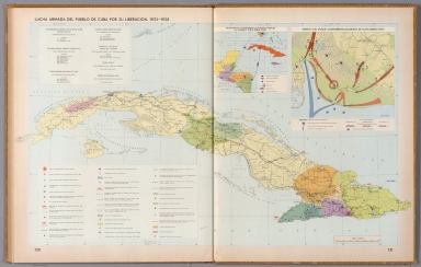
Full Title
Luchas armadas del pueblo Cuba por su liberacion, 1953-1958. Atlas nacional de Cuba : en el decimo aniversario de la Revolucion. La Habana 1970.
List No
13566.102
Note
Map of Cuba, with insets: Movimientos contrarrevolucionarios previos al ataque a playa Giron (1961); Derrota del ataque contrarrevolucionario en Playa Giron, (1961). Showing Armed struggles of the Cuban people for their liberation, the battle fields, the attack by land, sea and air and defeat of the counterrevolutionary attack in Playa Giron.
Author
News Map of the Week, Inc.
Full Title
World News of the Week : Monday, Oct. 25, 1943. Covering period Oct. 15 to Oct. 21. Volume 6, No. 8. Published and copyrighted (weekly), 1943, by News Map of the Week, Inc., 1512 Orleans Street, Chicago, Illinois. Published in two sections : Section one. Lithographed in U. S. A.
List No
14141.000
Note
Lithographed world map, in color. Shows political boundaries and military events of World War II, from October 15 to 21, 1943. Relief illustrated with hachures. Descriptive text throughout, e.g.: Mikhailovitch's army moves toward Danube. Map indexed according to historical notes beneath map. Features photographs, illustrations, and international time zones. With diagram: Growth of the United States Navy. Map is 56 x 115 cm, on sheet 89 x 120 cm, folded to 31 x 23 cm.
Author
News Map of the Week, Inc.
Full Title
World News of the Week : Monday, Nov. 1, 1943. Covering period Oct. 22 to Oct. 28. Volume 6, No. 9. Published and copyrighted (weekly), 1943, by News Map of the Week, Inc., 1512 Orleans Street, Chicago, Illinois. Published in two sections : Section one. Lithographed in U. S. A.
List No
14142.000
Note
Lithographed world map, in color. Shows political boundaries and military events of World War II, from October 22 to 28, 1943. Relief illustrated with hachures. Descriptive text throughout, e.g.: Famine threatens Calcutta. Map indexed according to historical notes beneath map. Features photographs, illustrations, and international time zones. With diagram: Parachutes. Map is 56 x 115 cm, on sheet 89 x 120 cm, folded to 31 x 23 cm.
Author
News Map of the Week, Inc.
Full Title
World News of the Week : Monday, Nov. 8, 1943. Covering period Oct. 29 to Nov. 4. Volume 6, No. 10. Published and copyrighted (weekly), 1943, by News Map of the Week, Inc., 1512 Orleans Street, Chicago, Illinois. Published in two sections : Section one. Lithographed in U. S. A.
List No
14143.000
Note
Lithographed world map, in color. Shows political boundaries and military events of World War II, from October 29 to November 4, 1943. Relief illustrated with hachures. Includes a key indicating the alignment of warring nations (United, Axis, and neutral). Descriptive text throughout, e.g.: Nazis trapped in Crimea. Map indexed according to historical notes beneath map. Features photographs, illustrations, and international time zones. With diagram: What our big cities are spending on children's education. Map is 56 x 115 cm, on sheet 89 x 120 cm, folded to 31 x 23 cm.
Author
News Map of the Week, Inc.
Full Title
World News of the Week : Monday, Nov. 22, 1943. Covering period Nov. 12 to Nov. 18. Volume 6, No. 12. Published and copyrighted (weekly), 1943, by News Map of the Week, Inc., 1512 Orleans Street, Chicago, Illinois. Published in two sections : Section one. Lithographed in U. S. A.
List No
14144.000
Note
Lithographed world map, in color. Shows political boundaries and military events of World War II, from November 12 to 18, 1943. Relief illustrated with hachures. Includes a key indicating the alignment of warring nations (United, Axis, and neutral). Descriptive text throughout, e.g.: Nazis capture Leros island. Map indexed according to historical notes beneath map. Features photographs, illustrations, and international time zones. With two inset maps: Bougainville close-up -- Hitler's headache. Map is 56 x 115 cm, on sheet 89 x 120 cm, folded to 31 x 23 cm.
Author
News Map of the Week, Inc.
Full Title
World News of the Week : Monday, Nov. 29, 1943. Covering period Nov. 19 to Nov. 25. Volume 6, No. 13. Published and copyrighted (weekly), 1943, by News Map of the Week, Inc., 1512 Orleans Street, Chicago, Illinois. Published in two sections : Section one. Lithographed in U. S. A.
List No
14145.000
Note
Lithographed world map, in color. Shows political boundaries and military events of World War II, from November 19 to 25, 1943. Relief illustrated with hachures. Descriptive text throughout, e.g.: Nazis claim capture of Samos. Map indexed according to historical notes beneath map. Features photographs, illustrations, and international time zones. With three diagrams: U. S. warplane production -- Record of American Air Forces - Dec. 7, 1941 to Sept. 1, 1943 -- Detailed record in four theaters. Map is 56 x 115 cm, on sheet 89 x 120 cm, folded to 31 x 23 cm.
Author
News Map of the Week, Inc.
Full Title
World News of the Week : Monday, Dec. 6, 1943. Covering period Nov. 26 to Dec. 2. Volume 6, No. 14. Published and copyrighted (weekly), 1943, by News Map of the Week, Inc., 1512 Orleans Street, Chicago, Illinois. Published in two sections : Section one. Lithographed in U. S. A.
List No
14146.000
Note
Lithographed world map, in color. Shows political boundaries and military events of World War II, from November 26 to December 2, 1943. Relief illustrated with hachures. Descriptive text throughout, e.g.: Roosevelt, Churchill, Chiange meet. Map indexed according to historical notes beneath map. Features photographs, illustrations, and international time zones. With diagram: Don't skid into the junk pile. Map is 56 x 115 cm, on sheet 89 x 120 cm, folded to 31 x 23 cm.
Author
News Map of the Week, Inc.
Full Title
World News of the Week : Monday, Dec. 13, 1943. Covering period Dec. 3 to Dec. 9. Volume 6, No. 15. Published and copyrighted (weekly), 1943, by News Map of the Week, Inc., 1512 Orleans Street, Chicago, Illinois. Published in two sections : Section one. Lithographed in U. S. A.
List No
14147.000
Note
Lithographed world map, in color. Shows political boundaries and military events of World War II, from December 3 to 9, 1943. Relief illustrated with hachures. Includes a table listing conferences, with dates, meeting locations, and conferencing parties (Roosevelt, Churchill, Hitler, Stalin, Mussolini). Descriptive text throughout, e.g.: Bolivia joins war on Axis. Map indexed according to historical notes beneath map. Features photographs, illustrations, and international time zones. With inset map: (Changsha). Also, with diagram: (December 1941 to December 1943 : U. S. airplane production -- U. S. naval strength -- U. S. military manpower -- U. S. casualties -- Japanese - U. S. naval losses. Map is 56 x 115 cm, on sheet 89 x 120 cm, folded to 31 x 23 cm.
Author
News Map of the Week, Inc.
Full Title
World News of the Week : Monday, Dec. 20, 1943. Covering period Dec. 10 to Dec. 16. Volume 6, No. 16. Published and copyrighted (weekly), 1943, by News Map of the Week, Inc., 1512 Orleans Street, Chicago, Illinois. Published in two sections : Section one. Lithographed in U. S. A.
List No
14148.000
Note
Lithographed world map, in color. Shows political boundaries and military events of World War II, from December 10 to 16, 1943. Relief illustrated with hachures. Descriptive text throughout, e.g.: Allies waging successful battle against U-boats. Map indexed according to historical notes beneath map. Features photographs, illustrations, and international time zones. With two inset maps: (Yugoslavia) -- (Rome). Map is 56 x 115 cm, on sheet 89 x 120 cm, folded to 31 x 23 cm.
Author
News Map of the Week, Inc.
Full Title
World News of the Week : Monday, Dec. 27, 1943. Covering period Dec. 17 to Dec. 23. Volume 6, No. 17. Published and copyrighted (weekly), 1943, by News Map of the Week, Inc., 1512 Orleans Street, Chicago, Illinois. Published in two sections : Section one. Lithographed in U. S. A.
List No
14149.000
Note
Lithographed world map, in color. Shows political boundaries and military events of World War II, from December 17 to 23, 1943. Relief illustrated with hachures. Descriptive text throughout, e.g.: Tito's forces cut Nazis' rail line. Map indexed according to historical notes beneath map. Features photographs, illustrations, and international time zones. Map is 56 x 115 cm, on sheet 89 x 120 cm, folded to 31 x 23 cm.
Author
China History Museum 中国历史博物馆
Full Title
[First Sino-Japanese War. 1894 - 1895.]. 中日战争图. 1894 - 1895年. [Zhong Ri zhan zheng tu. 1894 - 1895 nian].
List No
15078.002
Author
China History Museum 中国历史博物馆
Full Title
[Map of Peasant Rebellion during Late Qin Period]. 秦末农民战争图. [Qin mo nong min zhan zheng tu].
List No
15079.002
Author
China Cartographic Publishing House 地图出版社
Full Title
[Situation Map of Kingdoms of the Spring and Autumn Period] 春秋列国形势图. [Chun qiu lie guo xing shi tu].
List No
15080.002
Author
China History Museum 中国历史博物馆
Full Title
[Situation Map of the Yellow Turban Rebellion]. 黄巾起义形势图. [Huang jin qi yi xing shi tu].
List No
15081.002
Author
China History Museum 中国历史博物馆
Full Title
[Situation Map of National Protection Movement]. 护国运动形势图. [Hu guo yun dong xing shi tu].
List No
15082.002
Author
China History Museum 中国历史博物馆
Full Title
[Situation Map of National Protection Movement]. 中国原始社会氏族公社遗址分布图. [Zhongguo yuan shi she hui shi zu gong she yi zhi fen bu tu].
List No
15084.002
Author
[Canet Alvarez, Gerardo A., 1911-, Raisz, Erwin, 1893-1968, Harvard University. Institute of Geographical Exploration, Cuba. Ministerio de Agricultura]
Full Title
Cuba colonial : Siglo XVII -- Cuba en el siglo XVIII.
List No
14350.008
Note
Two maps showing the history of Cuba in the seventeenth through nineteenth centuries. Titles translate to: Colonial Cuba : 17th century -- Cuba in the 18th century. With inset bird's-eye view, which shows the city of Havana, illustrating its topography, vegetation, roads, points of interest and coastline. Includes illustrations and descriptive text, which appears in Spanish, with English translations. Accompanied by a timeline on left, which spans the dates 1600 to 1825 and lists historical events.
Author
[Canet Alvarez, Gerardo A., 1911-, Raisz, Erwin, 1893-1968, Harvard University. Institute of Geographical Exploration, Cuba. Ministerio de Agricultura]
Full Title
Cuba insurrecta : Primeras luchas -- La guerra del '68 -- La guerra del '95.
List No
14350.009
Note
Three maps showing the history of Cuba in the nineteenth and twentieth centuries. Titles translate to: Insurrectionary Cuba : First struggles -- The war of '68 -- The war of '95. Maps show cities, coastlines and locations of military events. Maps include pictorial elements and descriptive text, which appears in Spanish, with English translations. Accompanied by a timeline on left, which spans the dates 1840 to 1940 and lists historical events. With illustrations, charts and diagram, which represents population.
Author
Aspioti-ELKA (Firm)
Full Title
EΛΛHNOÏTAΛIKOΣ ΠOΛEMOΣ : ΠPΩTH ΠEPIOΔOΣ 28/10/1940-8/11/1940.
List No
14295.029
Note
Colored map of Greece, showing Italian military attacks on Greece from August 11th, 1940 to October 28th, 1940. Delineates between Greek and Albanian territory, where each suffered "Italian penetration". Also shows international political borders, cities, coastlines and islands. Includes a scale statement and an indexed legend, which the descriptive text on facing page explains. Accompanying text appears in Greek, French, English and Russian, entitled, The Italian agression. Description begins: But destiny prevented the Greek people from living and working in its poor country which he developed by his own toil ... Map is 39 x 31 cm, on sheet 47 x 35 cm. (Plate number 10, according to descriptive text.) Within the second section of the atlas, Greece at war.
Author
Aspioti-ELKA (Firm)
Full Title
EΛΛHNOΓEPMANIKOΣ ΠOΛEMOΣ : ΠPΩTH ΠEPIOΔOΣ 6 ATTP. - 17 ATTP. 1941.
List No
14295.033
Note
Colored map of Greece, showing German military attacks on Greece from April 6th to 17th, 1941. Delineates between German offensives during April 6-12 and April 13-17, 1941. First in a series of three maps that represent German attacks on Greece in 1941. Also shows international political borders, cities, coastlines and islands. Includes a scale statement and an indexed legend, which the descriptive text on facing page explains. Accompanying text appears in Greek, French, English and Russian, entitled, German attack A. Description begins: But the big Italian concentrations and Mussoini's spring offensives were all of no avail ... Map is 39 x 31 cm, on sheet 47 x 35 cm. (Plate number 12, according to descriptive text.) Within the second section of the atlas, Greece at war.
Author
Aspioti-ELKA (Firm)
Full Title
EXΘPIKH KATOXH-ΔIAMEΛIΣMOΣ THΣ XΩPAΣ : ΠPΩTH ΠEPIOΔOΣ 1941-1942.
List No
14295.039
Note
Colored map of Greece, showing the Italian, German and Bulgarian Occupation of Greece from 1943 to 1944. Delineates between the areas occupied by the Italians, Germans and Bulgarian. First in a series of four maps that represent military activity in Greece from 1941 to 1944. With national flags indicating boundaries. Also shows international political borders, cities, coastlines and islands. Includes a scale statement and an indexed legend, which the descriptive text on facing page explains. Accompanying text appears in Greek, French, English and Russian, entitled, Second phase of the Occupation. Description begins: At once the axis forces divided Greece into many zones and allocated them to the Germans, the Italians and the Bulgarians, who fell on the corpse of Greece in order to secure their reward for the assistance they gave to the Germans ... Map is 39 x 31 cm, on sheet 47 x 35 cm. (Plate number 15, according to descriptive text.) Within the second section of the atlas, Greece at war.
Author
Aspioti-ELKA (Firm)
Full Title
ΔIAMEΛIΣMOΣ THΣ XΩPAΣ KATA THN KATOXH : KAI OIKONOMIKH AΠOMONΩΣH TΩN ΔIAΦOPΩN ΠEPIOXΩN THΣ.
List No
14295.041
Note
Colored map of Greece, showing the dismemberment of Greece, circa 1942. Delineates between economic barriers, Bulgarian annexation, Italian occupation and Italian annexation. Second in a series of four maps that represent military activity in Greece from 1941 to 1944. Also shows international political borders, cities, coastlines and islands. Includes a scale statement and an indexed legend, which the descriptive text on facing page explains. Accompanying text appears in Greek, French, English and Russian, entitled, The dismemberment of the country. Description begins: With the division of the country into zones of Occupation the Axis divided Greece into small states ... Map is 39 x 31 cm, on sheet 47 x 35 cm. (Date based upon previous map in series.) (Plate number 16, according to descriptive text.) Within the second section of the atlas, Greece at war.
Author
Aspioti-ELKA (Firm)
Full Title
ΣYNOΛIKEΣ AΠΩΛEIEΣ OIKOΔOMΩN KATA AITIA : KATA TH KATOXH 1941-1944.
List No
14295.134
Note
Colored chart representing Greece, showing the destruction of buildings from 1941 to 1944. Delineates between different forms of damage, such as arson and looting, as well as perpetrators, including the Germans, Italians, Bulgarians and allied powers. Includes a legend. Accompanied by descriptive text on facing page in Greek, French, English and Russian, entitled, Total of damage to buildings. Description begins: All these destructions cost Greece the loss of 400,000 buildings, amounting to 23% of her wealth in buildings. Thus, Greece has paid the highest price amongst the allies ... Chart is 29 x 44 cm, on sheet 35 x 47 cm. (Plate number 60, according to descriptive text.) Within the fifth section of the atlas, Damage to towns and villages.
Author
Aspioti-ELKA (Firm)
Full Title
ΣΦAΓEΣ KAI EMПPHΣMOΣ KAΛABPYTΩN : TA ПYPПOΛHΘENTA KAΛABPYTA.
List No
14295.169
Note
Colored chart and map of Greece, showing the massacre of Kalavryta by the Germans during World War II. Map shows city plan, roads, topography and drainage. Relief shown with contour lines. Includes a legend. Accompanied by descriptive text on facing page in Greek, French, English and Russian, entitled, The massacres of Kalavryta. Description begins: The Germans applied a systematic programme of slaughter ... Within the sixth section of the atlas, The sufferings of the inhabitants ... Together, chart and map are 40 x 31 cm, on sheet 47 x 35 cm. (Plate number 77, according to descriptive text.) Within the sixth section of the atlas, The sufferings of the inhabitants.
Author
News Map of the Week, Inc.
Full Title
World News of the Week : Monday, May 4, 1942. Covering period Apr. 24 to 30. Volume 4, No. 35. Published and copyrighted (weekly), 1942, by News Map of the Week, Inc., 1512 Orleans Street, Chicago, Illinois. Published in two sections : Section one. Lithographed in U. S. A.
List No
14097.000
Note
Lithographed world map, in color. Shows political boundaries and military events of World War II, from April 24 to 30, 1942. Relief illustrated with hachures. Includes a legend indicating control by the Free French and Vichy France. Descriptive text throughout, e.g.: Area subject to semi-blackout. Map indexed according to historical notes beneath map. Features photographs, illustrations, and international time zones. With inset map: The War moves northward with the sun. Also, with diagram: Factory wages; Food prices; Income taxes; Installment buying. Map is 56 x 115 cm, on sheet 89 x 120 cm, folded to 31 x 23 cm.
Author
News Map of the Week, Inc.
Full Title
World News of the Week : Monday, May 11, 1942. Covering period May 1 to 7. Volume 4, No. 36. Published and copyrighted (weekly), 1942, by News Map of the Week, Inc., 1512 Orleans Street, Chicago, Illinois. Published in two sections : Section one. Lithographed in U. S. A.
List No
14098.000
Note
Lithographed world map, in color. Shows political boundaries and military events of World War II, from May 1 to 7, 1942. Relief illustrated with hachures. Descriptive text throughout, e.g.: Where Japanese warship concentration is reported. Map indexed according to historical notes beneath map. Features photographs, illustrations, and international time zones. With eight inset maps: The Japanese Empire, Manchukuo to Corregidor : Japan, 1930 -- Japan, 1932 -- Japan, before Pearl Harbor -- Japan, Dec. 7 - Jan. 7, 1942 -- Japan, Jan. 7 - Feb. 7, 1942 -- Japan, Feb. 7 - Mar. 7, 1942 -- Japan, Mar. 7 - Apr. 7, 1942 -- Japan, April 7 to present. Map is 56 x 115 cm, on sheet 89 x 120 cm, folded to 31 x 23 cm.
Author
News Map of the Week, Inc.
Full Title
World News of the Week : Monday, May 25, 1942. Covering period May 15 to 21. Volume 4, No. 38. Published and copyrighted (weekly), 1942, by News Map of the Week, Inc., 1512 Orleans Street, Chicago, Illinois. Published in two sections : Section one. Lithographed in U. S. A.
List No
14100.000
Note
Lithographed world map, in color. Shows political boundaries and military events of World War II, from May 15 to 21, 1942. Relief illustrated with hachures. Includes a legend indicating Japanese political sovereignty. Descriptive text throughout, e.g.: Where British, French clash occurred. Map indexed according to historical notes beneath map. Features photographs, illustrations, and international time zones. With four inset maps: Principal oil fields and pipelines of the U. S. -- Martinique -- Guadeloupe -- Dakar. Map is 56 x 115 cm, on sheet 89 x 120 cm, folded to 31 x 23 cm.
Author
News Map of the Week, Inc.
Full Title
World News of the Week : Monday, June 1, 1942. Covering period May 22 to 28. Volume 4, No. 39. Published and copyrighted (weekly), 1942, by News Map of the Week, Inc., 1512 Orleans Street, Chicago, Illinois. Published in two sections : Section one. Lithographed in U. S. A.
List No
14101.000
Note
Lithographed world map, in color. Shows political boundaries and military events of World War II, from May 22 to 28, 1942. Relief illustrated with hachures. Includes a legend indicating the sale of defense bonds in the United States. Descriptive text throughout, e.g.: Territory coveted by Italy. Map indexed according to historical notes beneath map. Features photographs, illustrations, and international time zones. With two inset maps: (Asia) -- (Russia). Also, with diagram: Planes; Tanks; Guns; Ships. Map is 56 x 115 cm, on sheet 89 x 120 cm, folded to 31 x 23 cm.
Author
News Map of the Week, Inc.
Full Title
World News of the Week : Monday, June 8, 1942. Covering period May 29 to June 4. Volume 4, No. 40. Published and copyrighted (weekly), 1942, by News Map of the Week, Inc., 1512 Orleans Street, Chicago, Illinois. Published in two sections : Section one. Lithographed in U. S. A.
List No
14102.000
Note
Lithographed world map, in color. Shows political boundaries and military events of World War II, from May 29 to June 4, 1942. Relief illustrated with hachures. Includes a legend indicating U. S. and Japanese bases, as well as bombings by Japan. Descriptive text throughout, e.g.: Chinese advance here. Map indexed according to historical notes beneath map. Features photographs, illustrations, and international time zones. With two inset maps: (Libya and Egypt) -- (Crucial battleground). Also, with diagram: Per capita income in the United States. Map is 56 x 115 cm, on sheet 89 x 120 cm, folded to 31 x 23 cm.
Author
News Map of the Week, Inc.
Full Title
World News of the Week : Monday, Sept. 7, 1942. Covering period Aug. 28 to Sept. 3. Volume 5, No. 1. Published and copyrighted (weekly), 1942, by News Map of the Week, Inc., 1512 Orleans Street, Chicago, Illinois. Published in two sections : Section one. Lithographed in U. S. A.
List No
14103.000
Note
Lithographed world map, in color. Shows political boundaries and military events of World War II, from August 28 to September 3, 1942. Relief illustrated with hachures. Descriptive text throughout, e.g.: Area Reds had retaken. Map indexed according to historical notes beneath map. Features photographs, illustrations, and international time zones. With two inset maps: Islands of the Pacific pinpoint battlefronts -- The world after three years of ever-widening war. Also, with pictures of aircraft symbols. Map is 56 x 115 cm, on sheet 89 x 120 cm, folded to 31 x 23 cm.
Author
News Map of the Week, Inc.
Full Title
World News of the Week : Monday, Sept. 14, 1942. Covering period Sept. 4 to Sept. 10. Volume 5, No. 2. Published and copyrighted (weekly), 1942, by News Map of the Week, Inc., 1512 Orleans Street, Chicago, Illinois. Published in two sections : Section one. Lithographed in U. S. A.
List No
14104.000
Note
Lithographed world map, in color. Shows political boundaries and military events of World War II, from September 4 to 10, 1942. Relief illustrated with hachures. Descriptive text throughout, e.g.: Allies complete vital railroad. Map indexed according to historical notes beneath map. Features photographs, illustrations, and international time zones. With six inset maps: How warring Germany has changed the face of Europe : 1914 -- 1919 -- 1939, Mar. 22 -- 1940, Sept. 1 -- 1941, Sept. 1 -- 1942, Sept. 1. Map is 56 x 115 cm, on sheet 89 x 120 cm, folded to 31 x 23 cm.
Author
News Map of the Week, Inc.
Full Title
World News of the Week : Monday, Sept. 21, 1942. Covering period Sept. 11 to Sept. 17. Volume 5, No. 3. Published and copyrighted (weekly), 1942, by News Map of the Week, Inc., 1512 Orleans Street, Chicago, Illinois. Published in two sections : Section one. Lithographed in U. S. A.
List No
14105.000
Note
Lithographed world map, in color. Shows political boundaries and military events of World War II, from September 11 to 17, 1942. Relief illustrated with hachures. Descriptive text throughout, e.g.: Area effected by fuel ration order. Map indexed according to historical notes beneath map. Features photographs, illustrations, and international time zones. With two inset maps: (Madagascar) -- The gates of Stalingrad. Also, with diagram: Ships; Tires; Steel. Map is 56 x 115 cm, on sheet 89 x 120 cm, folded to 31 x 23 cm.
Author
News Map of the Week, Inc.
Full Title
World News of the Week : Monday, Oct. 19, 1942. Covering period Oct. 9 to Oct. 15. Volume 5, No. 7. Published and copyrighted (weekly), 1942, by News Map of the Week, Inc., 1512 Orleans Street, Chicago, Illinois. Published in two sections : Section one. Lithographed in U. S. A.
List No
14107.000
Note
Lithographed world map, in color. Shows political boundaries and military events of World War II, from October 9 to 15, 1942. Relief illustrated with hachures. Descriptive text throughout, e.g.: Reds supply city during night by boat. Map indexed according to historical notes beneath map. Features photographs, illustrations, and international time zones. With diagram: Accidents increase; Time lost is costly; Steps in a safety campaign. Map is 56 x 115 cm, on sheet 89 x 120 cm, folded to 31 x 23 cm.
Author
News Map of the Week, Inc.
Full Title
World News of the Week : Monday, Oct. 26, 1942. Covering period Oct. 16 to Oct. 22. Volume 5, No. 8. Published and copyrighted (weekly), 1942, by News Map of the Week, Inc., 1512 Orleans Street, Chicago, Illinois. Published in two sections : Section one. Lithographed in U. S. A.
List No
14108.000
Note
Lithographed world map, in color. Shows political boundaries and military events of World War II, from October 16 to 22, 1942. Relief illustrated with hachures. Descriptive text throughout, e.g.: Italians fortify Dalmation coast. Map indexed according to historical notes beneath map. Features photographs, illustrations, and international time zones. With inset map: Guadalcanal : Cockpit of the Southwest Pacific. Also, with diagram: World gold production. Map is 56 x 115 cm, on sheet 89 x 120 cm, folded to 31 x 23 cm.
Author
News Map of the Week, Inc.
Full Title
World News of the Week : Monday, Dec. 15, 1941. Covering period Dec. 5 to Dec. 11. Volume 4, No. 15. Published and copyrighted (weekly), 1941, by News Map of the Week, Inc., 1512 Orleans Street, Chicago, Illinois. Published in two sections : Section one. Lithographed in U. S. A.
List No
14082.000
Note
Lithographed world map, in color. Shows political boundaries and military events of World War II, from December 5 to 11, 1941. Relief illustrated with hachures. Includes a legend indicating national sovereignty, including colonies. Descriptive text throughout, e.g.: Route over which Mexican forces will travel to Lower California. Map indexed according to historical notes beneath map. Features photographs, illustrations, and international time zones. With three inset maps: The Philippine Islands -- Japanese target -- Hitler's Best bets for winter. Also, with diagram: Aliens in America. Map is 56 x 115 cm, on sheet 89 x 120 cm, folded to 31 x 23 cm.
Author
News Map of the Week, Inc.
Full Title
World News of the Week : Monday, Dec. 22, 1941. Covering period Dec. 12 to Dec. 18. Volume 4, No. 16. Published and copyrighted (weekly), 1941, by News Map of the Week, Inc., 1512 Orleans Street, Chicago, Illinois. Published in two sections : Section one. Lithographed in U. S. A.
List No
14083.000
Note
Lithographed world map, in color. Shows political boundaries and military events of World War II, from December 12 to 18, 1941. Relief illustrated with hachures. Descriptive text throughout, e.g.: Tokyo reports troops landed here. Map indexed according to historical notes beneath map. Features photographs, illustrations, and international time zones. With three inset maps: (Hong Kong) -- (Tobruk) -- (World map showing Axis Powers and Allies). Also, with diagram: Comparative strength of the warring powers : Armies -- Air forces -- Navies. Map is 56 x 115 cm, on sheet 89 x 120 cm, folded to 31 x 23 cm.
Author
News Map of the Week, Inc.
Full Title
World News of the Week : Monday, Jan. 12, 1942. Covering period Jan. 2 to Jan. 8. Volume 4, No. 19. Published and copyrighted (weekly), 1942, by News Map of the Week, Inc., 1512 Orleans Street, Chicago, Illinois. Published in two sections : Section one. Lithographed in U. S. A.
List No
14084.000
Note
Lithographed world map, in color. Shows political boundaries and military events of World War II, from January 2 to 8, 1942. Relief illustrated with hachures. Descriptive text throughout, e.g.: British take total of 7,000 prisoners here. Map indexed according to historical notes beneath map. Features photographs, illustrations, and international time zones. With four inset maps: The fortress of Corregidor Island -- (Br. Malaya) -- Where U. S. trains troops for war -- Highlights of the War in 1941. Also, with diagram: U. S. donations for war relief. Map is 56 x 115 cm, on sheet 89 x 120 cm, folded to 31 x 23 cm.
|


![海國日本圖繪 紀元二千六百年紀念 / [Depiction of Maritime Japan, to Commemorate the 2600th Anniversary of the Imperial Family].](https://www.davidrumsey.com/rumsey/Size2/RUMSEY~8~1/205/15730000.jpg)


![[First Sino-Japanese War. 1894 - 1895.]. 中日战争图. 1894 - 1895年. [Zhong Ri zhan zheng tu. 1894 - 1895 nian].](https://www.davidrumsey.com/rumsey/Size2/RUMSEY~8~1/199/15078002.jpg)
![[Map of Peasant Rebellion during Late Qin Period]. 秦末农民战争图. [Qin mo nong min zhan zheng tu].](https://www.davidrumsey.com/rumsey/Size1/RUMSEY~8~1/199/15079002.jpg)
![[Situation Map of Kingdoms of the Spring and Autumn Period] 春秋列国形势图. [Chun qiu lie guo xing shi tu].](https://www.davidrumsey.com/rumsey/Size2/RUMSEY~8~1/199/15080002.jpg)
![[Situation Map of the Yellow Turban Rebellion]. 黄巾起义形势图. [Huang jin qi yi xing shi tu].](https://www.davidrumsey.com/rumsey/Size1/RUMSEY~8~1/199/15081002.jpg)
![[Situation Map of National Protection Movement]. 护国运动形势图. [Hu guo yun dong xing shi tu].](https://www.davidrumsey.com/rumsey/Size2/RUMSEY~8~1/199/15082002.jpg)
![[Situation Map of National Protection Movement]. 中国原始社会氏族公社遗址分布图. [Zhongguo yuan shi she hui shi zu gong she yi zhi fen bu tu].](https://www.davidrumsey.com/rumsey/Size2/RUMSEY~8~1/199/15084002.jpg)


![10. EΛΛHNOÏTAΛIKOΣ ΠOΛEMOΣ ...[The Italian aggression].](https://www.davidrumsey.com/rumsey/Size1/RUMSEY~8~1/195/14295029.jpg)
![12. EΛΛHNOΓEPMANIKOΣ ΠOΛEMOΣ ...[German attack A].](https://www.davidrumsey.com/rumsey/Size2/RUMSEY~8~1/195/14295033.jpg)
![15. EXΘPIKH KATOXH-ΔIAMEΛIΣMOΣ THΣ XΩPAΣ ...[The first phase of Occupation].](https://www.davidrumsey.com/rumsey/Size1/RUMSEY~8~1/195/14295039.jpg)
![16. ΔIAMEΛIΣMOΣ THΣ XΩPAΣ KATA THN KATOXH ...[The dismemberment of the country].](https://www.davidrumsey.com/rumsey/Size2/RUMSEY~8~1/195/14295041.jpg)
![60. ΣYNOΛIKEΣ AΠΩΛEIEΣ OIKOΔOMΩN KATA AITIA ...[Total of damage to buildings].](https://www.davidrumsey.com/rumsey/Size2/RUMSEY~8~1/195/14295134.jpg)
![77. ΣΦAΓEΣ KAI EMПPHΣMOΣ KAΛABPYTΩN ...[The massacres of Kalavryta].](https://www.davidrumsey.com/rumsey/Size2/RUMSEY~8~1/195/14295169.jpg)


