|
Author
Johnston, Alexander Keith, 1804-1871
Full Title
The Phenomena of Volcanic Action as Exemplified by the Regions Visited by Earthquakes, and the Distribution of Volcanoes over the Globe. I. Outlines of Volcanic Phenomena. (continued). II. Geographical Distribution of Volcanic Phenomena.
List No
0372AI
Author
Johnston, Alexander Keith, 1804-1871
Full Title
The Phenomena of Volcanic Action as Exemplified by the Regions Visited by Earthquakes, and the Distribution of Volcanoes over the Globe. II. Geographical Distribution of Volcanic Phenomena.(continued)
List No
0372AJ
Note
Distribution presented in a large table.
Author
Johnston, Alexander Keith, 1804-1871
Full Title
Comparative views of remarkable geological phenomena by A.K. Johnston, F.R.G.S. Engraved by W. & A.K. Johnston. William Blackwood & Sons, Edinburgh & London. (1856)
List No
0372.012
Note
Hand col. lithograph. Relief shown by hachures and spot heights. Contents: Plan of the volcanoes of Pichincha and Antisana surveyed by A. von Humboldt. Scale 1:200,000 -- Plans of the craters of Vesuvius and Etna by H. Abich, 1834. Scale 1:20,000 -- Physical map of the island of Teneriffe, by Leopold von Buch. Scale 1:550,000 -- Southern view of Etna from M.P.O. near Catania by W.S. Waltershausen -- View of the summit of the peak of Teneriffe and of the crater of elevation which surrounds it, from the east, by Leopold von Buch -- Chart of South Keeling Islands surveyed by the officers of H.M.S. Beagle. Scale 1:200,000 -- Chart of Ascension Island, surveyed by Lieutenant Campbell, R.N. Scale [1:200,000] -- View of Ascension Island from the mountain road -- Plan of the Crater of Cedee in the island of Java trigonometrically surveyed by Dr. Salomon Muller, 1836. Scale 1:20,000 -- Plan of Graham Island by Capt. C.H. Swinburne, 1831. Scale 1:20,000 -- Comparative view of the elevation of the principal active volcanoes on the globe -- Plan of Arthurs Seat, from an original survey. Scale 1:20,000. -- Samson's Ribs. "Geology no. 11."
Author
Johnston, Alexander Keith, 1804-1871
Full Title
Comparative Views of Remarkable Geological Phaenomena.
List No
0372AK
Author
Johnston, Alexander Keith, 1804-1871
Full Title
Comparative Views of Remarkable Geological Phaenomena. (continued)
List No
0372AL
Author
King, Clarence
Full Title
(Covers to) Engineer Department U.S.A. Geological and Topographical Atlas Accompanying the Report of the Geological Exploration of the Fortieth Parallel Made by the Authority of the Honorable Secretary of War under the direction of Brig. and Brvt. Major General A.A. Humphreys, Chief of Engineers U.S.A. by Clarence King, U.S. Geologist in Charge, 1876. Julius Bien Lith.
List No
0408A
Author
King, Clarence
Full Title
(Title Page to) Engineer Department U.S.A. Geological and Topographical Atlas Accompanying the Report of the Geological Exploration of the Fortieth Parallel Made by the Authority of the Honorable Secretary of War under the direction of Brig. and Brvt. Major General A.A. Humphreys, Chief of Engineers U.S.A. by Clarence King, U.S. Geologist in Charge, 1876. Julius Bien Lith.
List No
0408B
Note
Magnificent, huge atlas showing the area of the 40th Parallel Survey in topographical and geological maps. Wheat notes: "These are pioneer survey maps, and as such are most interesting. Mapping the West in so broad a cross-section had never before been attempted, a portent of things to come." King, at the age of 25, was made Geologist-in-charge of the Survey in 1867. He was formally ordered "to examine and describe the geological structure, geographical condition and natural resources of a belt of country extending from the 120th meridian eastward to the 105th meridian, along the 40th parallel of latitude with sufficient expansion north and south to include the lines of 'Central' and 'Union Pacific' railroads..." (Wheat). The topographical sheets depict features by brush shading rather than hachuring. In original binding -rare. Bound in green half leather with a label on the front, "Geological and Topographical Atlas Accompanying the Report of the Geological Exploration of the Fortieth Parallel. Clarence King, Geologist in Charge."
Author
King, Clarence
Full Title
(Index Page to) Engineer Department U.S.A. Geological and Topographical Atlas Accompanying the Report of the Geological Exploration of the Fortieth Parallel Made by the Authority of the Honorable Secretary of War under the direction of Brig. and Brvt. Major General A.A. Humphreys, Chief of Engineers U.S.A. by Clarence King, U.S. Geologist in Charge, 1876. Julius Bien Lith.
List No
0408C
Note
Index page includes the list of maps and a legend naming the mapmakers and the basis by which the maps were made.
Author
King, Clarence
Full Title
Cordilleras.
List No
0408.001
Note
Map in what came to be known as "plastic shading." The development of halftone lithography made this technique possible. The technique depicts surface features by brush shading rather than the more conventional hachuring. The map is in brown tones with the index maps highlighted in red.
Author
King, Clarence
Full Title
Rocky Mountains. Map I. (Geological)
List No
0408.002
Note
Map in full color with the legends on either side of the maps. Map extends from Cheyenne in the east to Fortification Peak in the west (Wyoming). Below the map are two geologic cross sections.
Author
King, Clarence
Full Title
Green River Basin. Map II. (Geological)
List No
0408.003
Note
Map in full color with the legends on either side of the maps. Map extends from Fortification Peak in Wyoming to Piedmont in Utah. Below the map are two geologic cross sections.
Author
King, Clarence
Full Title
Utah Basin. Map III. (Geological)
List No
0408.004
Note
Map in full color with the legends on either side of the maps. Map extends from Piedmont in Utah to Bovine, Utah including the Great Salt Lake. Below the map are two geologic cross sections.
Author
King, Clarence
Full Title
Nevada Plateau. Map IV. (Geological)
List No
0408.005
Note
Map in full color with the legends on either side of the maps. Map extends from Bovine, Utah across the Nevada plateau to Argenta, Nevada. Below the map are two geologic cross sections.
Author
King, Clarence
Full Title
Nevada Basin. Map V. (Geological)
List No
0408.006
Note
Map in full color with the legends on either side of the maps. Map extends from Argenta, Nevada to the west of Pyramid Lake (Lake Tahoe) in California. Below the map are two geologic cross sections.
Author
King, Clarence
Full Title
(Composite of) Geological Maps I-V, 40th Parallel Survey.
List No
0408.007
Note
Maps in full color with the legends on either side of the maps.
Author
King, Clarence
Full Title
General Sections.
List No
0408.008
Note
In full color. Ten sections shown with the legends on either side of the cross sections.
Author
[Ludlow, William, 1843-1901, United States. Army. Corps of Engineer]
Full Title
A geological map of the Black Hills: by Professor N.H. Winchell to accompany the report of Capt. William Ludlow U.S. Engineers. (to accompany) Report of a reconnaissance of the Black Hills of Dakota, made in the summer of 1874. By William Ludlow, Captain of Engineers, Bvt. Lieut. Colonel, U. S. Army; Chief Engineer Department of Dakota. Washington : Government Printing Office. 1875.
List No
0445.004
Note
Color geological map. Includes table of geologic formation. Relief shown by hachures and spot heights.
Author
Malte-Brun, Conrad, 1775-1826
Full Title
Carte Geologique d'Europe. Dressee par J.J.N. Huot, d'apres les travaux de M.M.A. Boue d'Omalius d'Halloy, de Buch et autres geologistes. No. 20 bis. Grave par Thierry. (1837)
List No
0458.023
Note
Engraved map. Geologic units listed in legend and depicted in full color. Major relief depicted with hachures. Rivers, lakes, islands, and regions shown. Includes 4 scales.
Author
Malte-Brun, Conrad, 1775-1826
Full Title
Carte Physique et Mineralogique des Isles Britanniques presentus les Bassins, les principales Montagnes, les Cours d'Eau, les Roches, et les substances Minerales. 1832. Grave par Thierry.
List No
0458.024
Note
Engraved map. Geologic units listed and described in legend and depicted in full color. Major relief depicted with hachures. Rivers, lakes, islands, and basins shown. Includes 2 scales.
Author
Malte-Brun, Conrad, 1775-1826
Full Title
Carte Physique et Mineralogique de la France presentant les Versans, les Bassins, les Montagnes, les Grandes Limites des Vegetation, la Pente des Principaux Cours d'Eau, les Roches, et les Substances Minerales, que recele son Sol. 1832. No. 21. Grave par Thierry.
List No
0458.025
Note
Engraved map. Geologic units listed and described in legend and depicted in full color. Major relief depicted with hachures. Rivers, lakes, islands, watersheds, and basins shown. Includes 2 scales. Inset of Corsica.
Author
Malte-Brun, Conrad, 1775-1826
Full Title
Coupes Geologiques. Coupe des terraines entre Paris et Colmar. Coupes des terraines dans les Pyrenees. Coupe des terrains entre le Cumberland et Durham (angleterre.) Coupe des terrains dans le Derbyshire. No. 20bis. Grave par Thierry.
List No
0458.026
Note
Engraved. Geologic units listed and described in legend and depicted in full color. Cross-sections in northern France, Pyrenees, and England.
Author
Martin de Moussy, V. (Victor), 1810-1869
Full Title
Carte physique de l'Amerique du Sud. Par le Dr. V. Martin de Moussy 1868. Grave par Kautz, r. Bonaparte 82, Paris. Paris, Imp. Lemercier et Cie., r. de Seine 57. (Paris Librairie de Firmin Didot Freres, Fils et Cie., 1873)
List No
0464.018
Note
Lithographed map. Geologic units hand col. Relief shown by hachures and spot heights. Shows geologic units (explanation on pl. XX), currents, etc. Includes inset map (uncolored) of the Galapagos. "Description geographique et statistique de la Confederation Argentine. Atlas. Planche XIX."
Author
Martin de Moussy, V. (Victor), 1810-1869
Full Title
Carte physique de la Confederation Argentine pour faire suite aux travaux de Mr. V. Martin de Moussy, 1869. Grave par L. Kautz, r. Bonaparte 82, Paris. Paris, Imp. Lemercier et Cie., r. de Seine 57. (Paris Librairie de Firmin Didot Freres, Fils et Cie., 1873)
List No
0464.019
Note
Lithographed map. Geologic units hand col. Relief shown by hachures and spot heights. Shows also locations of flora, fauna and mineral deposits. Covers northern portion of country (from 420 north). "Description geographique et statistique de la Confederation Argentine. Atlas. Planche XX."
Author
[Martin de Moussy, V. (Victor), 1810-1869, Sourdeaux, A.]
Full Title
Coupes geologiques diverses. Grave par L. Kautz, r. Bonaparte 82, Paris. Paris, Imp. Lemercier, r. de Seine 57. (Paris Librairie de Firmin Didot Freres, Fils et Cie., 1873)
List No
0464.020
Note
Four groups of thirteen geologic columns. Lithographed. Contents: Coupe geologique des Berges du Fleuve Parana (Rive Gauche) dans les Provinces d'Entre Rios et de Corrientes -- Coupe geologique des puits artesiens de la piedad et de barracas a Buenos-Ayres (d'apres Mr. A. Sourdeaux directeur des travaux) -- Coupes geologiques des terrains tertiaires formant la cote de l'Ocean atlantique, depuis le Cap Corrientes jusqu'au detroit de Magellan -- Coupe geologique des barrancas, ou falaises voisines du Rio Negro. "Description geographique et statistique de la Confederation Argentine. Atlas. Planche XXI."
Author
Martin de Moussy, V. (Victor), 1810-1869
Full Title
Coupes geologiques diverses - altitudes. Grave par Kautz, r. Bonaparte 82 - Paris. Paris - Imp. Lemercier, r. de Seine 57. (Paris Librairie de Firmin Didot Freres, Fils et Cie., 1873)
List No
0464.021
Note
Six groups of geologic columns and profiles, and 4 drawings showing the relative elevations of mountains. Lithographed. Contents: Coupes generale des terrains tertiaires -- Section est ouest des plaines de la Patagonie -- Coupe generale des terrains de la Rive ... du Rio Parana -- Coupes geologiques des divers points des cotes de la Patagonie reconnus par C. Darwin -- Montagnes de la Terre de Feu -- Systeme des petites Sierras du Sud: Vulcan, Tandil, Tinta, Azul -- Systeme orographique des cotes de la Patagonie -- Systeme des Sierras de la Ventana, Cruza-Malal et Guamini. "Description geographique et statistique de la Confederation Argentine. Atlas. Planche XXII."
Author
Maury, Matthew Fontaine, 1806-1873
Full Title
VII. Geological agency of the winds. D. McClelland, Sc. (to accompany) The Physical Geography of the Sea. By M.F. Maury. An Entirely New Edition, With Addenda.
List No
0475.014
Note
Uncolored map. Includes explanation and notes. Shows how the winds may become geological agent.
Author
[Desbuissons, L.E., Migeon, J.]
Full Title
France Geologique. Grave par Lecocq. Dresse Sous La Direction De J. Migeon Par Ch. Lacoste. Les Eaux par Fontaine. Ecrit par A. Bizet. (1892). Fillatreau del. and Barbier sc. (for vignette).
List No
0507.019
Note
Full color by rock type. Relief shown by hachures. Vignette of Grotte de Royat. Inset of Corsica.
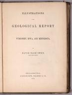
Author
Owen, David Dale
Full Title
(Covers to) Report of a Geological Survey of Wisconsin, Iowa and Minnesota; and incidentally of a Portion of Nebraska Territory ... by David Dale Owen, United States Geologist. Philadelphia: Lippincott, Grambo & Co. 1852. (with) Illustrations to the Geological Report of Wisconsin, Iowa, and Minnesota ... 1852. (on verso of title page) Philadelphia: C. Sherman, Printer, 19 St. James Street.
List No
0690.001
Note
Report of Geological survey and Illustrations and maps in separate volume. Illustrations volume includes twenty-one maps and geologic cross sections as well as numerous drawings. Large full color map bound into the back titled, "Geological Map of Wisconsin, Iowa and Minnesota ... Constructed from observations by the United States Geological Corps ... 1851." Report bound with green cloth covered boards with title embossed on spine. Illustrations bound with purple cloth covered boards with "Illustrations - Owen's Geological Survey" on cover in gold.
Author
Owen, David Dale
Full Title
(Title Page to) Report of a Geological Survey of Wisconsin, Iowa and Minnesota; and incidentally of a Portion of Nebraska Territory ... by David Dale Owen, United States Geologist. Philadelphia: Lippincott, Grambo & Co. 1852. (with) Illustrations to the Geological Report of Wisconsin, Iowa, and Minnesota ... 1852. (on verso of title page) Philadelphia: C. Sherman, Printer, 19 St. James Street.
List No
0690.002
Note
Report of Geological survey and Illustrations and maps in separate volume. Illustrations volume includes twenty-one maps and geologic cross sections as well as numerous drawings. Large full color map bound into the back titled, "Geological Map of Wisconsin, Iowa and Minnesota ... Constructed from observations by the United States Geological Corps ... 1851." Report bound with green cloth covered boards with title embossed on spine. Illustrations bound with purple cloth covered boards with "Illustrations - Owen's Geological Survey" on cover in gold. View of Falls of Pigeon River on opposite title page.
Author
Owen, David Dale
Full Title
(Covers to) Illustrations to the Geological Report of Wisconsin, Iowa, and Minnesota. By David Dale Owen, United States Geologist. Philadelphia: Lippincott, grambo & Co.1852. (with) Report of a Geological Survey of Wisconsin, Iowa and Minnesota; and incidentally of a Portion of Nebraska Territory ... by David Dale Owen ... 1852. (on verso of title page) Philadelphia: C. Sherman, Printer, 19 St. James Street.
List No
0690.003
Note
Illustrations and maps and Report of Geological survey in separate volume. Illustrations volume includes twenty-one maps and geologic cross sections as well as numerous drawings. Large full color map bound into the back titled, "Geological Map of Wisconsin, Iowa and Minnesota ... Constructed from observations by the United States Geological Corps ... 1851." Report bound with green cloth covered boards with title embossed on spine. Illustrations bound with purple cloth covered boards with "Illustrations - Owen's Geological Survey" on cover in gold.
Author
Owen, David Dale
Full Title
(Title Page to) Illustrations to the Geological Report of Wisconsin, Iowa, and Minnesota. By David Dale Owen, United States Geologist. Philadelphia: Lippincott, grambo & Co.1852. (with) Report of a Geological Survey of Wisconsin, Iowa and Minnesota; and incidentally of a Portion of Nebraska Territory ... by David Dale Owen ... 1852. (on verso of title page) Philadelphia: C. Sherman, Printer, 19 St. James Street.
List No
0690.004
Note
Illustrations and maps and Report of Geological survey in separate volume. Illustrations volume includes twenty-one maps and geologic cross sections as well as numerous drawings. Large full color map bound into the back titled, "Geological Map of Wisconsin, Iowa and Minnesota ... Constructed from observations by the United States Geological Corps ... 1851." Report bound with green cloth covered boards with title embossed on spine. Illustrations bound with purple cloth covered boards with "Illustrations - Owen's Geological Survey" on cover in gold.
Author
Owen, David Dale
Full Title
Table I. Trilobites of the lowest sandstones of Wisconsin and Minnesota. (on opposite page view of) Medal-ruled, on steel, from the original Specimens. J.M. Butler. (to accompany) Illustrations to the Geological Report of Wisconsin, Iowa, and Minnesota. (with) Report of a Geological Survey of Wisconsin, Iowa and Minnesota ... 1852.
List No
0690.005
Note
Descriptive list of the specimens and 14 uncolored views from original specimens.
Author
Owen, David Dale
Full Title
Table I A. Trilobites and Fucoidal impressions, from the lowest Protozoic sandstones, F.I., of Wisconsin and Minnesota. (on opposite page view of) Medal-ruled, on steel, from the original Specimens. J.M. Butler. (to accompany) Illustrations to the Geological Report of Wisconsin, Iowa, and Minnesota. (with) Report of a Geological Survey of Wisconsin, Iowa and Minnesota ... 1852.
List No
0690.006
Note
Descriptive list of the specimens and 14 uncolored views from original specimens.
Author
Owen, David Dale
Full Title
Table I B. Specimens containing Lingula, Obolus, and Orbicula, from near the base of the lowest Protozoic sandstones of Wisconsin and Minnesota. (on opposite page view of) Medal-ruled, on steel, from the original Specimens. J.M. Butler. (to accompany) Illustrations to the Geological Report of Wisconsin, Iowa, and Minnesota. (with) Report of a Geological Survey of Wisconsin, Iowa and Minnesota ... 1852.
List No
0690.007
Note
Descriptive list of the specimens and 13 uncolored views from original specimens.
Author
Owen, David Dale
Full Title
Table I C. Fossil, plants, (?) from the Red Sandstones on the Noethwest shore of Lake Superior. From drawings, by J. Chappellsmith. (on opposite page view by) J. Cappell Smith, del. J.M. Butler. (to accompany) Illustrations to the Geological Report of Wisconsin, Iowa, and Minnesota. (with) Report of a Geological Survey of Wisconsin, Iowa and Minnesota ... 1852.
List No
0690.008
Note
Descriptive list of the specimens and 8 uncolored views.
Author
Owen, David Dale
Full Title
Table I D. Mud Furrows, (?) and impressions of plants (?), in the red sandstones of the northwest shore of Lake Superior. Medal ruled on steel from original specimens. (on opposite page view) by R. Whitechurch & B. P. Newman at J. M. Butler's Establishment. (to accompany) Illustrations to the Geological Report of Wisconsin, Iowa, and Minnesota. (with) Report of a Geological Survey of Wisconsin, Iowa and Minnesota ... 1852.
List No
0690.009
Note
Descriptive list of the specimens and 3 uncolored views.
Author
Owen, David Dale
Full Title
Table II. Trilobites, from F. III., A; Gasteropoda and Brachipoda, from F. II., and F. III., A; Together with Fucoidal impressions, (?) from the red sandstones of Lake Superior. (on opposite page view) D.D. Owen, del. J. M. Butler. (to accompany) Illustrations to the Geological Report of Wisconsin, Iowa, and Minnesota. (with) Report of a Geological Survey of Wisconsin, Iowa and Minnesota ... 1852.
List No
0690.010
Note
Descriptive list of the specimens and 13 uncolored views.
Author
Owen, David Dale
Full Title
Table II A. Trilobites and Brachipoda, from the Protozoic rocks of the northwest. Medal ruled on steel from original specimens. (on opposite page view) J. M. Butler. (to accompany) Illustrations to the Geological Report of Wisconsin, Iowa, and Minnesota. (with) Report of a Geological Survey of Wisconsin, Iowa and Minnesota ... 1852.
List No
0690.011
Note
Descriptive list of the specimens and 12 uncolored views.
Author
Owen, David Dale
Full Title
Table II B. Fossils of the shell-beds (F. III., A) and overlying lead-bearing beds (F. III., B) of the upper Magnesian limestone of Wisconsin, Iowa, and Minnesota. Medal ruled on steel from original specimens. (on opposite page view) J. M. Butler. (to accompany) Illustrations to the Geological Report of Wisconsin, Iowa, and Minnesota. (with) Report of a Geological Survey of Wisconsin, Iowa and Minnesota ... 1852.
List No
0690.012
Note
Descriptive list of the specimens and 23 uncolored views.
Author
Owen, David Dale
Full Title
Table III. Spirifers, Orthis and Strophodonta, from the shell-beds of the Iowa and Cedar Rivers, belonging to the Devonian Period. (on opposite page view) D.D. Owen. W.H. Dougal. (to accompany) Illustrations to the Geological Report of Wisconsin, Iowa, and Minnesota. (with) Report of a Geological Survey of Wisconsin, Iowa and Minnesota ... 1852.
List No
0690.013
Note
Descriptive list of the specimens and 19 uncolored views.
Author
Owen, David Dale
Full Title
Table III A. Fossil shells and corals from the carboniferous limestone, and from the adjacent limestones of Iowa of the age of Hamilton Group of New York. (on opposite page view) Medal ruled on steel from original specimens. J.M. Butler. (to accompany) Illustrations to the Geological Report of Wisconsin, Iowa, and Minnesota. (with) Report of a Geological Survey of Wisconsin, Iowa and Minnesota ... 1852.
List No
0690.014
Note
Descriptive list of the specimens and 21 uncolored views.
Author
Owen, David Dale
Full Title
Table IV. Fossil corals, from the carboniferous rocks of Iowa. (on opposite page view) D.D. Owen, del. J.M. Butler. (to accompany) Illustrations to the Geological Report of Wisconsin, Iowa, and Minnesota. (with) Report of a Geological Survey of Wisconsin, Iowa and Minnesota ... 1852.
List No
0690.015
Note
Descriptive list of the specimens and 8 uncolored views.
Author
Owen, David Dale
Full Title
Table V. Fossil shells from the carboniferous rocks of Iowa and Nebraska. (on opposite page view) D.D. Owen, del. J.M. Butler. (to accompany) Illustrations to the Geological Report of Wisconsin, Iowa, and Minnesota. (with) Report of a Geological Survey of Wisconsin, Iowa and Minnesota ... 1852.
List No
0690.016
Note
Descriptive list of the specimens and 17 uncolored views.
Author
Owen, David Dale
Full Title
Table V A. New species of Crinoidea of the carboniferous limestone. (on opposite page view) D.D. Owen, & J. Chappel Smith, del. J.M. Butler. (to accompany) Illustrations to the Geological Report of Wisconsin, Iowa, and Minnesota. (with) Report of a Geological Survey of Wisconsin, Iowa and Minnesota ... 1852.
List No
0690.017
Note
Descriptive list of the specimens and 16 uncolored figures in 35 views.
Author
Owen, David Dale
Full Title
Table V B. New species of Crinoidea of the carboniferous limestone. (on opposite page view) D.D. Owen, del. J.M. Butler. (to accompany) Illustrations to the Geological Report of Wisconsin, Iowa, and Minnesota. (with) Report of a Geological Survey of Wisconsin, Iowa and Minnesota ... 1852.
List No
0690.018
Note
Descriptive list of the specimens and 7 uncolored figures in 13 views.
Author
Owen, David Dale
Full Title
Table VI. Lepidodendrons and fossil ferns, characteristic of the carboniferous sandstones, muscatine quarries, Iowa. (on opposite page view) D.D. Owen, del. J.M. Butler. (to accompany) Illustrations to the Geological Report of Wisconsin, Iowa, and Minnesota. (with) Report of a Geological Survey of Wisconsin, Iowa and Minnesota ... 1852.
List No
0690.019
Note
Descriptive list of the specimens and 8 uncolored views.
Author
Owen, David Dale
Full Title
Table VII. Fossil shells characteristic of the cretaceous formation of Nebraska. (on opposite page view) D.D. Owen. Figuers 2,3,4, and 5, Medal-ruled by R. Whitechurch at J.M. Butler's Establishment. (to accompany) Illustrations to the Geological Report of Wisconsin, Iowa, and Minnesota. (with) Report of a Geological Survey of Wisconsin, Iowa and Minnesota ... 1852.
List No
0690.020
Note
Descriptive list of the specimens and 11 figures in 12 uncolored views.
Author
Owen, David Dale
Full Title
Table VIII. Ammonites and Scaphites, from the cretaceous formation of Nebraska. (on opposite page view) D.D. Owen. Figuers 1,2,3,4, 5 & 7, Medal-ruled by R. Whitechurch at J.M. Butler's Establishment. (to accompany) Illustrations to the Geological Report of Wisconsin, Iowa, and Minnesota. (with) Report of a Geological Survey of Wisconsin, Iowa and Minnesota ... 1852.
List No
0690.021
Note
Descriptive list of the specimens and 7 figures in 11 uncolored views.
Author
Owen, David Dale
Full Title
Table VIII A. Inoceramus and Ammonite, from the cretaceous formation of Nebraska. (on opposite page view) Medal-ruled on steel from original speciment, by R. Whitechurch at J.M. Butler's Establishment. (to accompany) Illustrations to the Geological Report of Wisconsin, Iowa, and Minnesota. (with) Report of a Geological Survey of Wisconsin, Iowa and Minnesota ... 1852.
List No
0690.022
Note
Descriptive list of the specimens and 2 uncolored views.
Author
Owen, David Dale
Full Title
Table IX. Remains of the Rhinoceros and the gigantic Paleotherium of the Ecocene Tertiary of the Mauvaises Terres of Nebraska. (on opposite page view) D.D. Owen. W.H. Dougal. (to accompany) Illustrations to the Geological Report of Wisconsin, Iowa, and Minnesota. (with) Report of a Geological Survey of Wisconsin, Iowa and Minnesota ... 1852.
List No
0690.023
Note
Descriptive list of the specimens and 3 figures in 4 uncolored views.
Author
Owen, David Dale
Full Title
Table X. Remains of Archeotherium and Oreodon of the Eocene tertiary of Nebraska. (on opposite page view) Engraved on steel from daguerreotypes of the original specimens by A.B. Walter, Phila(delphia). (to accompany) Illustrations to the Geological Report of Wisconsin, Iowa, and Minnesota. (with) Report of a Geological Survey of Wisconsin, Iowa and Minnesota ... 1852.
List No
0690.024
Note
Descriptive list of the specimens and 6 uncolored views.
Author
Owen, David Dale
Full Title
Table XI. Additional remains of Archeotherium and Oreodon. All figures of the natural size. (on opposite page view) D.D. Owen, del. A.B. Walter Sc. (to accompany) Illustrations to the Geological Report of Wisconsin, Iowa, and Minnesota. (with) Report of a Geological Survey of Wisconsin, Iowa and Minnesota ... 1852.
List No
0690.025
Note
Descriptive list of the specimens and 3 uncolored views.
Author
Owen, David Dale
Full Title
Table XII. Remains of a species of land turtle, from the Eocene tertiary of Nebraska. (on opposite page view) D.D. Owen. Engraved on steel from daguerreotype of original specimens by J. McGoffin, at J.M. Butler's Establishment. (to accompany) Illustrations to the Geological Report of Wisconsin, Iowa, and Minnesota. (with) Report of a Geological Survey of Wisconsin, Iowa and Minnesota ... 1852.
List No
0690.026
Note
Descriptive list of the specimens and 2 uncolored views.
Author
Owen, David Dale
Full Title
Table XII A. Two species of land turtles, Machairodus, or Sabre-toothed Tiger, and a small species of Rhinoceros from the Eocene Tertiary of Nebraska. (on opposite page view) Engraved on steel from daguerreotype of original specimens. J.M. Butler. (to accompany) Illustrations to the Geological Report of Wisconsin, Iowa, and Minnesota. (with) Report of a Geological Survey of Wisconsin, Iowa and Minnesota ... 1852.
List No
0690.027
Note
Descriptive list of the specimens and 6 uncolored views.
Author
Owen, David Dale
Full Title
Table XII B. Remains of a land turtle, Rhinoceros, and Paleotherium, from the Eocene Tertiary of Nebraska. (on opposite page view) Fig. 1 & 2 engraved on steel from daguerreotype of original specimens. J.M. Butler. (to accompany) Illustrations to the Geological Report of Wisconsin, Iowa, and Minnesota. (with) Report of a Geological Survey of Wisconsin, Iowa and Minnesota ... 1852.
List No
0690.028
Note
Descriptive list of the specimens and 8 uncolored views.
Author
Owen, David Dale
Full Title
Table XIII. Remains of Archaeotherium and Oreodon, from the Eocene Tertiary of Nebraska. Figures are all of the natural size. (on opposite page view) J.M. Butler. (to accompany) Illustrations to the Geological Report of Wisconsin, Iowa, and Minnesota. (with) Report of a Geological Survey of Wisconsin, Iowa and Minnesota ... 1852.
List No
0690.029
Note
Descriptive list of the specimens and 6 uncolored views.
Author
Owen, David Dale
Full Title
Table XIV. Remains of the Rhinoceros, from the Eocene Tertiary of Nebraska. All the figures are reduced one-third. (on opposite page view) J.M. Butler. (to accompany) Illustrations to the Geological Report of Wisconsin, Iowa, and Minnesota. (with) Report of a Geological Survey of Wisconsin, Iowa and Minnesota ... 1852.
List No
0690.030
Note
Descriptive list of the specimens and 3 uncolored views.
Author
Owen, David Dale
Full Title
Table XV. Remains of Eucrotaphus and of the Rhinoceros, from the Eocene Tertiary of Nebraska. All the figures are of natural size. (on opposite page view) Engraved from the original specimens by J.M. Butler. (to accompany) Illustrations to the Geological Report of Wisconsin, Iowa, and Minnesota. (with) Report of a Geological Survey of Wisconsin, Iowa and Minnesota ... 1852.
List No
0690.031
Note
Descriptive list of the specimens and 4 uncolored views.
Author
Owen, David Dale
Full Title
Map showing the positions of the Bad Lands or Mauvaises Terres of Nebraska, from a draft by John Evens of the U.S. Geological Survey. (to accompany) Illustrations to the Geological Report of Wisconsin, Iowa, and Minnesota. (with) Report of a Geological Survey of Wisconsin, Iowa and Minnesota ... 1852.
List No
0690.032
Note
Uncolored map. Shows rivers, forts, mountains. Relief shown by hachures.
Author
Owen, David Dale
Full Title
Geological map of parts of Minnesota and Wisconsin. Designed to show portions of the Rock formations now concealed by drift. By J.G. Norwood. Drawn by J. Chappell smith. (to accompany) Illustrations to the Geological Report of Wisconsin, Iowa, and Minnesota. (with) Report of a Geological Survey of Wisconsin, Iowa and Minnesota ... 1852.
List No
0690.033
Note
Hand color map. References indicated on the maps are Limestones of Cedar Valley, Upper and Lower Magnesium Limestone, Lowest Sandstones, Metamorphic Schists, and Granite & Sienitic Rocks. Prime meridian is Washington.
Author
Owen, David Dale
Full Title
General connected section of the rocks exposed on the North shore of Lake Superior between Fond du Lac Superieur and Pigeon Point, as observed during the geological surveys of Wisconsin & Minnesota territory, in the year 1848, 49 & 50, under the direction of David Dale Owen, M.D. United States Geologist. By Richard Owen. (to accompany) Illustrations to the Geological Report of Wisconsin, Iowa, and Minnesota. (with) Report of a Geological Survey of Wisconsin, Iowa and Minnesota ... 1852.
List No
0690.034
Note
Hand color geologic cross section on sheet 31x135 cm. folded to 31x20. with explanation of rock formations.
Author
Owen, David Dale
Full Title
Geological map: Coast view and section of Pigeon Point. By Richard Owen. Engd. on steel by W.H. Dougal, Washington, D.C. Cost section from the West end of Grand Portage Bay to the extremity of Pigeon Point in direction North of East. By Richard Owen. (on upper right margin) Pl.N. (to accompany) Illustrations to the Geological Report of Wisconsin, Iowa, and Minnesota. (with) Report of a Geological Survey of Wisconsin, Iowa and Minnesota ... 1852.
List No
0690.035
Note
Hand color geologic map and cross section, folded to 31x21 cm., with uncolored view of the coast folded to 31x20 cm. On upper right margin Pl.N.
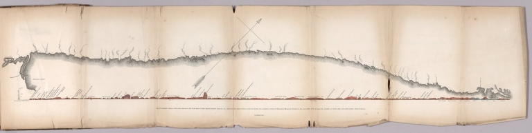
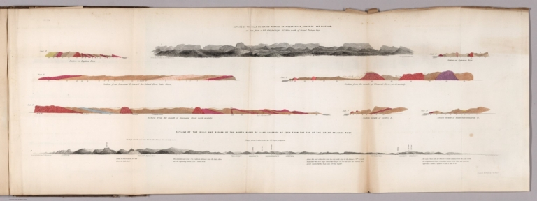
Author
Owen, David Dale
Full Title
Outline of the hills on Grand Portage of Pigeon River, North of Lake Superior: as seen from hill 650 feet high - 4 1/2 miles north of Grand Portage Bay. (with) Outline of the hills and ridges of the north shore of Lake Superior as seen from the top of the Great Palisade Rock. From an outline by J.G. Norwood. Engraved & printed by J.M. Butler. (to accompany) Illustrations to the Geological Report of Wisconsin, Iowa, and Minnesota. (with) Report of a Geological Survey of Wisconsin, Iowa and Minnesota ... 1852.
List No
0690.036
Note
Hand color geologic cross sections, folded to 31x21 cm., showing geologic formations. With 2 uncolored outline view of hills north shore of Lake Superior showing elevation in feet, Includes detail explanation. On upper right margin Pl. 1 N.
Author
Owen, David Dale
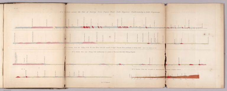
Full Title
No. 1: Section cross the line of bearing from Pigeon Point Lake Superior, North Westerly, to Lake Saganaga. No. 2: Section from the valley of the St. Croix River near the mount of Upper Pinnette River, northerly, to Rainy Lake. No. 3: Section from near Portage Lake southeasterly to a point on Wisconsin River below Whitney's Rapids. No. 4: (untitled: from Big Bull Falls to Whitney's Mill) No. 5: Section from the mouth of Kinechegakwag Cr. toward Cloquet River. by J.G. Norwood. Engraved & printed by J.M. Butler. (to accompany) Illustrations to the Geological Report of Wisconsin, Iowa, and Minnesota. (with) Report of a Geological Survey of Wisconsin, Iowa and Minnesota ... 1852.
List No
0690.037
Note
5 geologic cross sections, hand colored, folded to 31x21 cm. Includes detail explanation. On upper left margin Pl. 2 N.
Author
Owen, David Dale
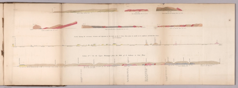
Full Title
Sec. 1. Section on Mission Creek, by J.G.N. Sec.2. Lake shore above Kamanasisatikag River, by J.G.N. Sec. 3. Lake shore between Split Rock and Gooseberry River, by J.G.N. Sec.4. Section of Palisade River, by J.G.N. Sec 4, S. Section showing the succession, elevation and depression of the rocks on the St. Peters River... By F. B. Shumard. Sec. 5. Section on the west fork of Palisade River, by J.G.N. Sec. 6. Section on Cut-Face River, by J.G.N. Section No. 7, on the upper Mississippi from the falls to St. Anthony to Corw Wing. (to accompany) Illustrations to the Geological Report of Wisconsin, Iowa, and Minnesota. (with) Report of a Geological Survey of Wisconsin, Iowa and Minnesota ... 1852.
List No
0690.038
Note
8 geologic cross sections, hand colored, folded to 31x21 cm. Includes detail explanation. On upper left margin Pl. 3 N.
Author
Owen, David Dale
Full Title
No.1. Section of the summit levels, showing the general elevation of the country between the mouth of Chippewa river and the mouth of Bad River, above lake Superior. No. 2. Section of the summit levels, showing the general elevation of the country between the Mississippi River, at St. Pauls, and St. Louis river ... No. 3. Section of the summit levels, showing the general elevation of the country between the Mississippi river at the outlet of Lake St. Croix and the mouth of Bois Brule river. From Barometrical Measurements make during a Geological Reconnoisance of the Chippewa Land District, under the direction of David Dale Owen, ... and J.G. Norwood ... (to accompany) Illustrations to the Geological Report of Wisconsin, Iowa, and Minnesota. (with) Report of a Geological Survey of Wisconsin, Iowa and Minnesota ... 1852.
List No
0690.039
Note
3 uncolored cross sections, folded to 31x21 cm. Includes detail explanation.
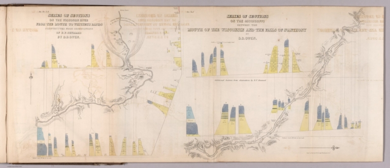
Author
Owen, David Dale
Full Title
Sec. No. 3 S. Series of sections on the Wisconsin River from the mouth to Whitneys Rapids; Constructed from observations of B.F. Shumard, by D.D. Owen. Sec. No. 1. Series of sections on the Mississippi between the mouth of the Wisconsin river and the Falls of St. Anthony, by D.D. Owen. Engd. on steel by W.H. Dougal, Washington, D.C. (to accompany) Illustrations to the Geological Report of Wisconsin, Iowa, and Minnesota. (with) Report of a Geological Survey of Wisconsin, Iowa and Minnesota ... 1852.
List No
0690.040
Note
Maps and cross sections, folded to 31x21 cm. Relief shown by hachures and spot heights.
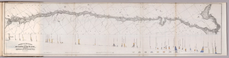
Author
Owen, David Dale
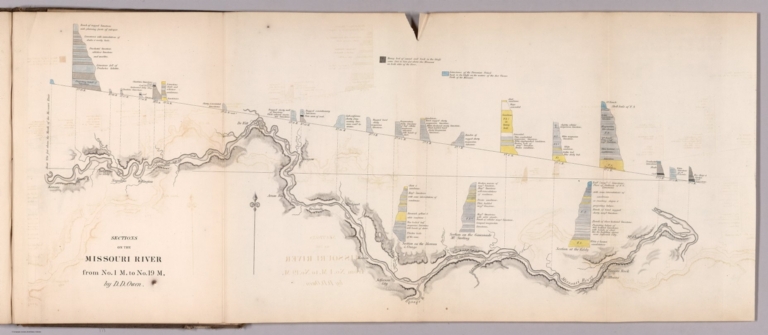
Full Title
Sections on the Missouri River, from No.1 M, to No. 19 M, by D.D. Owen. (to accompany) Illustrations to the Geological Report of Wisconsin, Iowa, and Minnesota. (with) Report of a Geological Survey of Wisconsin, Iowa and Minnesota ... 1852.
List No
0690.041
Note
Map and cross sections, folded to 31x21 cm. Shows settlements and forts. Relief shown by hachures. Include note and explanations.
Author
Owen, David Dale
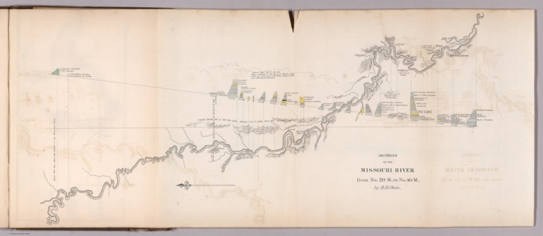
Full Title
Sections on the Missouri River, from No. 20 M, to No. 40 M, by D.D. Owen. (to accompany) Illustrations to the Geological Report of Wisconsin, Iowa, and Minnesota. (with) Report of a Geological Survey of Wisconsin, Iowa and Minnesota ... 1852.
List No
0690.042
Note
Map and colored cross sections, folded to 31x21 cm. Relief shown by hachures and spot heights. Include explanations.
Author
Owen, David Dale
Full Title
Series of sections on the Des Moines River in Iowa, between the Mississippi and the Racoon Fork, by D.D. Owen. Acherman Lith. 379 Broadway, N.Y. (to accompany) Illustrations to the Geological Report of Wisconsin, Iowa, and Minnesota. (with) Report of a Geological Survey of Wisconsin, Iowa and Minnesota ... 1852.
List No
0690.043
Note
Map and colored cross sections, folded to 31x21 cm. Shows settlements and forts. Geologic cross-sections shown in color. Relief shown by hachures. Include explanations.
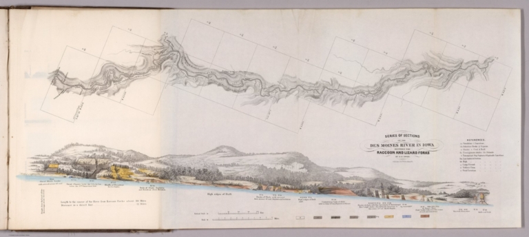
Author
Owen, David Dale
Full Title
Series of sections on the Des Moines River in Iowa, between the Racoon and Lizard Forks, by D.D. Owen. Acherman Lith. 379 Broadway, N.Y. (to accompany) Illustrations to the Geological Report of Wisconsin, Iowa, and Minnesota. (with) Report of a Geological Survey of Wisconsin, Iowa and Minnesota ... 1852.
List No
0690.044
Note
Map and color cross sections, folded to 31x21 cm. Shows settlements and forts. Geologic cross-sections shown in color. Relief shown by hachures. Include reference and explanations.
Author
Owen, David Dale
Full Title
Sec. 2. Section along the course of the Mississippi from the mouth of Wisconsin River to Prairie a la Crosse River. (and) Thence by Mountain Island, Cape de Killio, Miniskah, Wazi-Oju and Chippewa Rivers; to Lake Pepin. (with) thence by mouths of Cannon River, Lake St. Croix and St. Peter's River, to the Falls of St. Anthony. Ackerman Lith. 379 Broadway N.Y.(to accompany) Illustrations to the Geological Report of Wisconsin, Iowa, and Minnesota. (with) Report of a Geological Survey of Wisconsin, Iowa and Minnesota ... 1852.
List No
0690.045
Note
3 color cross sections, folded to 31x21 cm.
Author
Owen, David Dale
Full Title
Sec. 3. Section on the St. Croix of the succession, thickness, relative elevation of F.1 & F.2. with their subordinatemembers. By D. Owen. Ackerman Lith. 379 Broadway N.Y. (to accompany) Illustrations to the Geological Report of Wisconsin, Iowa, and Minnesota. (with) Report of a Geological Survey of Wisconsin, Iowa and Minnesota ... 1852.
List No
0690.046
Note
A-F color cross sections, folded to 31x21 cm.
Author
Owen, David Dale
Full Title
Sec. No. 4. Section showing the relative thickness and dip of the lower Magnesian Limestone (F. No.2) and underlying sandstone. With its subordinate beds (F. No.1. b.c.d.e, and f) from the Mississippi River, to the trap exposure at the Falls of St. Croix. By D. Owen. Ackerman Lith. 379 Broadway N.Y. (to accompany) Illustrations to the Geological Report of Wisconsin, Iowa, and Minnesota. (with) Report of a Geological Survey of Wisconsin, Iowa and Minnesota ... 1852.
List No
0690.047
Note
3 color cross sections, folded to 31x21 cm. With views of hills and lake. Relief shown pictorially.
Author
Owen, David Dale
Full Title
Sec. No.5. Geological section on Mississippi River from the mouth of Lake St. Croix to 1 mile above the fall of St. Anthony ... Constructed from observation made by D.D. Owen & B.F. Shumard. Ackerman Lith. 379 Broadway N.Y. (to accompany) Illustrations to the Geological Report of Wisconsin, Iowa, and Minnesota. (with) Report of a Geological Survey of Wisconsin, Iowa and Minnesota ... 1852.
List No
0690.048
Note
4 color cross sections, folded to 31x21 cm. Showing geologic formations. Relief shown pictorially.
Author
Owen, David Dale
Full Title
Sections accompanying the report of Chas. Whittlesey on the Bad River District of south shore Lake Superior. Elevation principally by Dr. Norwood. Ackerman Lith. 379 Broadway N.Y. (to accompany) Illustrations to the Geological Report of Wisconsin, Iowa, and Minnesota. (with) Report of a Geological Survey of Wisconsin, Iowa and Minnesota ... 1852.
List No
0690.049
Note
4 color cross sections, folded to 31x21 cm. Includes: Section No.1.W. Section from the mouth of Apukwaekan of Flag River, south east by south 55 miles to the head of Tyler's Fork. (with)m Section No.2.W. Section of the rocks from the Maringouin Fork of Bad River ... (with) Section No.3.W. Section from the Falls of the East Fork to Bad River ... (with) Section No.4. W. Section from the mouth of Montreal River ... Includes notes.
Author
Owen, David Dale
Full Title
Sec. 2.N. Section by A. Randall along the line of the 4th. P.M. from Lake Superior to the Mississippi ... (with) Section by A. Randall along the 3rd. correction from the Mississippi R. to 4th. P.M. Sec.3 R. Section of hills at the Chippewe red pipestone locality between the Chippewe and Red Cedar Rivers ... By A. randall. Sec. 1 R. Section on Black river from granite at the Falls to sandstone F.1.a. By A. Randall. (with) Geological section at Falls of St. Anthony. By B.F. Shumard. Ackerman Lith. 379 Broadway N.Y. (to accompany) Illustrations to the Geological Report of Wisconsin, Iowa, and Minnesota. (with) Report of a Geological Survey of Wisconsin, Iowa and Minnesota ... 1852.
List No
0690.050
Note
5 color cross sections, folded to 31x21 cm.
Author
Owen, David Dale
Full Title
No. 6. Section on the Iowa side of the Mississippi 30 miles below Lake Pepin at a Great Slide. Ackerman Lith. 379 Broadway N.Y. (to accompany) Illustrations to the Geological Report of Wisconsin, Iowa, and Minnesota. (with) Report of a Geological Survey of Wisconsin, Iowa and Minnesota ... 1852.
List No
0690.051
Note
Color cross section.
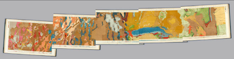
Author
Owen, David Dale
Full Title
Geological map of Wisconsin, Iowa and Minnesota : exhibiting, also, the extension of the Iowa coal-field into Missouri, and its relation to the Illinois coal-field / constructed from observations by the United States Geological Corps, under instructions from the Secretary of the Treasury, by David Dale Owen ; middle, northern and northeastern Minnesota by J.G. Norwood ; the greater part of the southern shore of Lake Superior, in Wisconsin, by Col. Chas. Whittlesey. 1851. Engraved by W. Smith. Washn. (to accompany) Illustrations to the Geological Report of Wisconsin, Iowa, and Minnesota. (with) Report of a Geological Survey of Wisconsin, Iowa and Minnesota ... 1852. Inset: Geological map of the north shore of Lake Superior : on the scale of the original m.s. map. Scale [ca. 1:600,000].
List No
0690.052
Note
Hand colored geological map. Shows geological formations via hand coloring. It also shows the Iowa coal-field extending into northern Missouri and part of the Illinois coal-field. There is excellent detail of watershed and lakes throughout. Includes Table showing geological formation by color.
Author
[Colton, J.H., Parker, Nathan H.]
Full Title
(Covers to) Parker's Sectional & Geological Map Of Iowa. Exhibiting her Iron Lead Copper Coal and other Geological Resources And All Rail Roads Completed, in progress, and projected. Compiled from the U.S. Surveys and personal reconnoisance. By Nathan H. Parker. Author of "Iowa As It Is" Clinton Io. 1856. J.H. Colton & Co. 172 William St. New York. D.B. Cooke & Co. Chicago Ill. Entered ... 1856, by N.H. Parker... Iowa. Engraved, Printed And Mounted By J.H. Colton & Co. 172 William Street, New York. (inset) Map Showing the Connections between the Iowa And Eastern Rail Roads.
List No
0699.001
Note
Large scale map of the state, showing coal, iron, lead, and plaster formations, as well as a few finished railroads in the eastern portions, and many proposed or constructing railroads extending westward. There is a list of "Railroads In Iowa" in the lower left. Although "copper" is mentioned in the title, we can find no copper formations listed or in the key. Full color by county. Folded into stamped red cloth covers 16x10.5 with "Sectional And Geological Map Of Iowa N.H. Parker." stamped in gilt.
Author
[Colton, J.H., Parker, Nathan H.]
Full Title
Parker's Sectional & Geological Map Of Iowa. Exhibiting her Iron Lead Copper Coal and other Geological Resources And All Rail Roads Completed, in progress, and projected. Compiled from the U.S. Surveys and personal reconnoisance. By Nathan H. Parker. Author of "Iowa As It Is" Clinton Io. 1856. J.H. Colton & Co. 172 William St. New York. D.B. Cooke & Co. Chicago Ill. Entered ... 1856, by N.H. Parker... Iowa. Engraved, Printed And Mounted By J.H. Colton & Co. 172 William Street, New York. (inset) Map Showing the Connections between the Iowa And Eastern Rail Roads.
List No
0699.002
Note
Large scale map of the state, showing coal, iron, lead, and plaster formations, as well as a few finished railroads in the eastern portions, and many proposed or constructing railroads extending westward. There is a list of "Railroads In Iowa" in the lower left. Although "copper" is mentioned in the title, we can find no copper formations listed or in the key. Full color by county. Folded into stamped red cloth covers 16x10.5 with "Sectional And Geological Map Of Iowa N.H. Parker." stamped in gilt.
Author
Polish Army Topography Service
Full Title
Geology. Tectonics. Pergamon World Atlas. Pergamon Press, Ltd. & P.W.N. Poland 1967. Sluzba Topograficzna W.P.
List No
0737.020
Note
Two maps. Lands classified by geologic periods. Tectonic features in 33 categories, both continental and oceanic.
Author
Polish Army Topography Service
Full Title
Quaternary. Geomorphology. Pergamon World Atlas. Pergamon Press, Ltd. & P.W.N. Poland 1967. Sluzba Topograficzna W.P.
List No
0737.021
Note
Two maps. Includes maximum extent of ice sheets and mountain glaciation. Shows various types of deposits such as glacial, fluvial, marine, and colluvial. Geomorphology map provides landforms such as loess, sedimentary plateaus, volcanic rocks, alpine mountains, etc.
Full Title
The Hurricane Fault. (1895)
List No
0740.039
Note
Uncolored view and cross section.
Full Title
Temples and towers of the Rio Virgen. (1895)
List No
0740.041
Note
Uncolored view. See also our List No. 4713.003.
Full Title
Panorama. Upper view looking east, with the Grand Canyon in the distance. Lower view looking down the Toroweap. (1895)
List No
0740.042
Note
Uncolored view. See also our List Number 4713.009.
Author
Nichols, H. H.
Full Title
Recent lava flow on the Uinkaret. H.H. Nichols. (1895)
List No
0740.086
Note
Uncolored view.
Full Title
A gable with pinnacles (Grand Canyon, Ariz. 1895)
List No
0740.111
Note
Uncolored view.
Full Title
Niches or panels in the Red Wall limestone (Grand Canyon, Ariz. 1895)
List No
0740.112
Note
Uncolored view.
Full Title
Rounded inward curves and projecting cusps of the walls (Grand Canyon, Ariz. 1895)
List No
0740.113
Note
Uncolored map. Relief shown by hachures.
Full Title
Key to the panorama from Point Sublime--looking east. (1895)
List No
0740.120
Note
Uncolored view.
Full Title
Key to the panorama from Point Sublime--looking west. (1895)
List No
0740.121
Note
Uncolored view.
Full Title
Key to the panorama from Point Sublime--looking south. (1895)
List No
0740.122
Note
Uncolored view.
Full Title
Grand Canyon at the foot of the Toroweap, looking east. (1895)
List No
0740.123
Note
Uncolored view.
Author
[Reynolds, James, Emslie, John]
Full Title
Diagram of Natural Phenomena. Drawn and engraved by John Ernslie. London, Published by James Reynolds 174 Strand. April 2, 1852. (to accompany) Geological Diagrams.
List No
0848.006
Note
Geological diagram showing the principal causes of geological changes on the Earth's surface, identified by a reference beneath the illustration.
Author
[Reynolds, James, Emslie, John]
Full Title
Phenomena of Volcanoes and Earthquakes, showing the influence exerted by the heated interior of the earth upon its external surface. Drawn and engraved by John Emslie. London, Published by James Reynolds 174 Strand. June 3, 1852. (inset views) Principal volcanic mountains. (with) The Great geyser Iceland. (with) Destruction of the city of Lisbon by the great earthquake Novr. 1st. 1755. (to accompany) Geological Diagrams.
List No
0848.007
Note
Hand colored map of the world showing the distribution and names of all active volcanoes, identified by a reference beneath the illustration. Includes notes.
Author
[Reynolds, James, Emslie, John]
Full Title
Popular geology. Drawn and engraved by John Emslie. London, Published by James Reynolds 174 Strand. Oct. 1st.,1849. (to accompany) Geological Diagrams.
List No
0848.009
Note
Hand colored time table chart showing the geological section of the earth's crust. The map also has notes and diagrams illustrating fossil remains, rocks, and view of section of the London Basin - artesian wells.
Author
[Reynolds, James, Emslie, John]
Full Title
(Text Page to) Table of Geological Strata, order of superposition and distinctive characters of the various Stratified rocks; with their mean thicknesses, and some of the localities where they are found. London: Published by James Reynolds 174 Strand. (to accompany) Geological Diagrams.
List No
0848.010
Note
Table of geological Strata, showing the order of superposition and comparative thickness of the Stratified rocks.
Author
[Reynolds, James, Emslie, John]
Full Title
Geological map of the world. Drawn and engraved by John Emslie. Published by James Reynolds 174 Strand. London. (inset views) Ice barriers of the Polar Regions.(with) Coral Reefs. (with) Island of Cyclps Mediterranean. (with) Barren Island, Bay of Bengal. (with) Cape Pillar, Van Dieman's Land. (to accompany) Geological Diagrams.
List No
0848.011
Note
Hand color engraved map, shows the worldwide distribution of various rock types. Includes reference identifying: alluvium (sedimentary), igneous (primary, secondary & tertiary), metamorphic (changed) and volcanic.
Author
[Reynolds, James, Emslie, John]
Full Title
Geological map of England. London. Published by James Reynolds 174 Strand. Decr. 13th. 1849. (inset views) Slate quarries. (with) Coal mining. (with) The Needles Isle of Wight. (with cross section) Section of the Line A-B. (to accompany) Geological Diagrams.
List No
0848.012
Note
Hand color engraved map. Dhowing colour-coded areas of rock formations in England. with note: "Primary series colored blue, Secondary series green, Tertiary series yellow". Includes reference identifying the geologic rock formation, text, and cross section. Chart is one of a series of 44 educational charts drawn and engraved by John Emslie. The first geological map of Britain, indeed of any country in the world, was published by William Smith (1769-1839) in 1815.
Author
[Reynolds, James, Emslie, John]
Full Title
Geological map of Scotland. Drawn and engraved by John Emslie. London. Published by James Reynolds 174 Strand. (inset) Shetland Isles. (inset views) Strathaired, Skye Fissures left vacant by decomposed trap. (with) Granite Rocks to the south of Hillswick Ness Shetland. (with) Fingal's Cave, Island of Staffa. (with) Rock and Spindle standrews. (with) Remarkable cured Strata of slate new St. Abb's Head. (to accompany) Geological Diagrams.
List No
0848.013
Note
Hand color engraved map, showing areas of rock formations in Scotland. Includes colour-coded reference identifying the geologic rock formation, and note. Date estimated. Chart is one of a series of 44 educational charts drawn and engraved by John Emslie. The first geological map of Britain, indeed of any country in the world, was published by William Smith (1769-1839) in 1815.
Author
[Reynolds, James, Emslie, John]
Full Title
Geological map of Ireland. London. Published by James Reynolds 174 Strand. Decr. 13th. 1849. (inset views) Giant's Causeway. (with) The Twelve Pins, Connamara. (with) Fosilelk of Ireland. (to accompany) Geological Diagrams.
List No
0848.014
Note
Hand color engraved map. showing areas of rock formations in Ireland. Includes colour-coded reference identifying the geologic rock formation, and text. Date estimated. Chart is one of a series of 44 educational charts drawn and engraved by John Emslie. The first geological map of Britain, indeed of any country in the world, was published by William Smith (1769-1839) in 1815.
Author
Roe Brothers (Firm)
Full Title
Geological map of the Maritime Provinces of the Dominion of Canada. (with) Newfoundland. (Drawn on the Rectangular polyconic projection. Drawn and published by Roe Brothers, (A.D. & W.B. Roe). Eng. by Worley & Bracher, Philada. Printed by F. Bourquin, Philada. 1878)
List No
0859.001
Note
Hand colored map. Shows 9 geologic units, settlements, railroads, etc.
Author
Russell, Israel C. (Israel Cook), 1852-1906.
Full Title
(Title Page to) Department of Interior : Monographs of the United States Geological Survey, vol. XI. House of Representative : 49th Congress, 1st Session. Mis. Doc. No. 304. Washington : Government printing Office 1885. Geological history of Lake Lahontan : a quaternary lake of Northwestern Nevada ; by Israel Cook Russell. (at head to title) United States Geological Survey; J.W. Powell, Director.
List No
0866.001
Note
Geological history of Lake Lahontan, published in U.S.G.S. Monograph vol. 11. Includes maps, views, diagrams, cross-sections and tables.
Author
Russell, Israel C. (Israel Cook), 1852-1906.
Full Title
(Title Page to) Geological history of Lake Lahontan : a quaternary lake of Northwestern Nevada ; by Israel Cook Russell. (at head to title) United States Geological Survey; J.W. Powell, Director. (series title) Department of Interior : Monographs of the United States Geological Survey, vol. XI. House of Representative : 49th Congress, 1st Session. Mis. Doc. No. 304. Washington : Government printing Office 1885.
List No
0866.002
Note
Geological history of Lake Lahontan, published in U.S.G.S. Monograph vol. 11. Includes maps, views, diagrams, cross-sections and tables.
Author
Russell, Israel C. (Israel Cook), 1852-1906.
Full Title
Quaternary lakes of the Great Basin. Julius Bien & Co. Lith. (to accompany) Geological history of Lake Lahontan : a quaternary lake of Northwestern Nevada. (series title) Department of Interior : Monographs of the United States Geological Survey, vol. XI. (on upper margin) U.S. Geological Survey; Lake Lahontan PL. I.
List No
0866.003
Note
Color map. Shows lake, rivers and major cities. Depth shown by isolines.
Author
Russell, Israel C. (Israel Cook), 1852-1906.
Full Title
Routes traveled and areas surveyed. Julius Bien & Co. Lith. (to accompany) Geological history of Lake Lahontan : a quaternary lake of Northwestern Nevada. (series title) Department of Interior : Monographs of the United States Geological Survey, vol. XI. (on upper margin) U.S. Geological Survey; Lake Lahontan PL. II.
List No
0866.004
Note
Color map. Shows lake, rivers, routes explored by I.C. Russell and scientific assistants. Areas survey marked in blue. Relief shown by shadings. Depth shown by isolines.
Author
Russell, Israel C. (Israel Cook), 1852-1906.
Full Title
Pre-Quternary fault lines. Julius Bien & Co. Lith. (to accompany) Geological history of Lake Lahontan : a quaternary lake of Northwestern Nevada. (series title) Department of Interior : Monographs of the United States Geological Survey, vol. XI. (on upper margin) U.S. Geological Survey; Lake Lahontan PL. III.
List No
0866.005
Note
Color map. Shows lake and rivers. Fault lines shown in red. Relief shown by shadings. Depth shown by isolines.
Author
Russell, Israel C. (Israel Cook), 1852-1906.
Full Title
Map of Lake Lahontan : showing water area and boundary of hydrographic basin by Israel C. Russell. Julius Bien & Co. Lith. (to accompany) Geological history of Lake Lahontan : a quaternary lake of Northwestern Nevada. (series title) Department of Interior : Monographs of the United States Geological Survey, vol. XI. (on upper margin) U.S. Geological Survey; Lake Lahontan PL. IV.
List No
0866.006
Note
Color map. Includes legend. Relief shown by shadings. Depth shown by isolines.
Author
Russell, Israel C. (Israel Cook), 1852-1906.
Full Title
Depth of Lake Lahontan at highest water stage. Julius Bien & Co. Lith. (to accompany) Geological history of Lake Lahontan : a quaternary lake of Northwestern Nevada. (series title) Department of Interior : Monographs of the United States Geological Survey, vol. XI. (on upper margin) U.S. Geological Survey; Lake Lahontan PL. V.
List No
0866.007
Note
Color map. Relief shown by shadings. Depth shown by isolines and soundings in feet.
Author
Russell, Israel C. (Israel Cook), 1852-1906.
Full Title
Map showing land classification of Lahontan Region. Julius Bien & Co. Lith. (to accompany) Geological history of Lake Lahontan : a quaternary lake of Northwestern Nevada. (series title) Department of Interior : Monographs of the United States Geological Survey, vol. XI. (on upper margin) U.S. Geological Survey; Lake Lahontan PL. VI.
List No
0866.008
Note
Color map. Relief shown by shadings. Depth shown by isolines.
Author
Russell, Israel C. (Israel Cook), 1852-1906.
Full Title
Carson Desert, Nevada. Julius Bien & Co. Lith. (to accompany) Geological history of Lake Lahontan : a quaternary lake of Northwestern Nevada. (series title) Department of Interior : Monographs of the United States Geological Survey, vol. XI. (on upper margin) U.S. Geological Survey; Lake Lahontan PL. VII.
List No
0866.009
Note
Color map. Shows railroad, rivers and lakes. Relief shown by contours and shadings. "Interval between countours 1000 feet".
Author
Russell, Israel C. (Israel Cook), 1852-1906.
Full Title
Springs of the Lahontan Region. Julius Bien & Co. Lith. (to accompany) Geological history of Lake Lahontan : a quaternary lake of Northwestern Nevada. (series title) Department of Interior : Monographs of the United States Geological Survey, vol. XI. (on upper margin) U.S. Geological Survey; Lake Lahontan PL. VIII.
List No
0866.010
Note
Color map. Shows Existing springs, railroad, rivers, lakes and temperature in Farenheit. Relief shown by shadings.
Author
Russell, Israel C. (Israel Cook), 1852-1906.
Full Title
Pyramid and Winnemucca Lakes, Nevada. W.D. Johnson, Topograper. I.C. Russell, Geologist. (to accompany) Geological history of Lake Lahontan : a quaternary lake of Northwestern Nevada. (series title) Department of Interior : Monographs of the United States Geological Survey, vol. XI. (on upper margin) U.S. Geological Survey; Lake Lahontan PL. IX.
List No
0866.011
Note
Uncolored map. Relief shown by hachures. Depth shown by isolines and soundings in feet.
Author
Russell, Israel C. (Israel Cook), 1852-1906.
Full Title
Anaho Island, Pyramid Lake, Nevada. W.D. Johnson, Topograper. I.C. Russell, Geologist. (to accompany) Geological history of Lake Lahontan : a quaternary lake of Northwestern Nevada. (series title) Department of Interior : Monographs of the United States Geological Survey, vol. XI. (on upper margin) U.S. Geological Survey; Lake Lahontan PL. X.
List No
0866.012
Note
Uncolored map. Relief shown by hachures. Depth shown by soundings in feet.
Author
Russell, Israel C. (Israel Cook), 1852-1906.
Full Title
Sketch of Pyramid Island, Pyramid Lake, Nevada. (to accompany) Geological history of Lake Lahontan : a quaternary lake of Northwestern Nevada. (series title) Department of Interior : Monographs of the United States Geological Survey, vol. XI. (on upper margin) U.S. Geological Survey; Lake Lahontan PL. XI.
List No
0866.013
Note
Uncolored view of Pyramid Island.
Author
Russell, Israel C. (Israel Cook), 1852-1906.
Full Title
The Needles, Pyramid Lake, Nevada. (to accompany) Geological history of Lake Lahontan : a quaternary lake of Northwestern Nevada. (series title) Department of Interior : Monographs of the United States Geological Survey, vol. XI. (on upper margin) U.S. Geological Survey; Lake Lahontan PL. XII.
List No
0866.014
Note
Uncolored view of the Needles at the north end of Pyramid Lake.
Author
Russell, Israel C. (Israel Cook), 1852-1906.
Full Title
Among the Needles, Pyramid Lake, Nevada. (to accompany) Geological history of Lake Lahontan : a quaternary lake of Northwestern Nevada. (series title) Department of Interior : Monographs of the United States Geological Survey, vol. XI. (on upper margin) U.S. Geological Survey; Lake Lahontan PL. XIII.
List No
0866.015
Note
Uncolored view of the Needles at the north end of Pyramid Lake.
Author
Russell, Israel C. (Israel Cook), 1852-1906.
Full Title
Mushroom Rock, north shore of Anaho Island. (to accompany) Geological history of Lake Lahontan : a quaternary lake of Northwestern Nevada. (series title) Department of Interior : Monographs of the United States Geological Survey, vol. XI. (on upper margin) U.S. Geological Survey; Lake Lahontan PL. XIV.
List No
0866.016
Note
Uncolored view of Mushroom Rock.
Author
Russell, Israel C. (Israel Cook), 1852-1906.
Full Title
Walker Lake, Nevada. W.D. Johnson, Topographer. I.C. Russell, Geologist. (to accompany) Geological history of Lake Lahontan : a quaternary lake of Northwestern Nevada. (series title) Department of Interior : Monographs of the United States Geological Survey, vol. XI. (on upper margin) U.S. Geological Survey; Lake Lahontan PL. XV.
List No
0866.017
Note
Uncolored map. Relief shown by hachures. Depth shown by isolines and soundings in feet.
Author
Russell, Israel C. (Israel Cook), 1852-1906.
Full Title
Soda Lakes near Ragtown, Nevada. W.D. Johnson, Topographer. I.C. Russell, Geologist. (to accompany) Geological history of Lake Lahontan : a quaternary lake of Northwestern Nevada. (series title) Department of Interior : Monographs of the United States Geological Survey, vol. XI. (with inset).
List No
0866.018
Note
Color map, with inset of vertical profile of Soda Lake. Relief shown by contours. Depth shown by isolines and soundings in feet. "Contours 20 feet apart".
Author
Russell, Israel C. (Israel Cook), 1852-1906.
Full Title
Section of the crater walls inclosing the Soda Lakes, Nevada. W.J. McGee. Del. I.C. Russell, Geologist. (to accompany) Geological history of Lake Lahontan : a quaternary lake of Northwestern Nevada. (series title) Department of Interior : Monographs of the United States Geological Survey, vol. XI. (on upper margin) U.S. Geological Survey; Lake Lahontan PL. XVII.
List No
0866.019
Note
5 uncolored geologic cross-section of Soda Lakes.
Author
Russell, Israel C. (Israel Cook), 1852-1906.
Full Title
Gravel embarkments at west end of Humboldt Lake, Nevada. W.D. Johnson. Topographer. I.C. Russell, Geologist. (to accompany) Geological history of Lake Lahontan : a quaternary lake of Northwestern Nevada. (series title) Department of Interior : Monographs of the United States Geological Survey, vol. XI. (on upper margin) U.S. Geological Survey; Lake Lahontan PL. XVIII.
List No
0866.020
Note
Uncolored map, with inset vertical profile of Humboldt Lake. Shows railroads. Relief shown by hachures. Depth shown by soundings.
Author
Russell, Israel C. (Israel Cook), 1852-1906.
Full Title
Gravel embarkments on south border of the Carson Desert, Nevada. W.D. Johnson. Topographer. I.C. Russell, Geologist. (to accompany) Geological history of Lake Lahontan : a quaternary lake of Northwestern Nevada. (series title) Department of Interior : Monographs of the United States Geological Survey, vol. XI. (on upper margin) U.S. Geological Survey; Lake Lahontan PL. XIX.
List No
0866.021
Note
Uncolored map. Shows railroads. Relief shown by hachures.
Author
Russell, Israel C. (Israel Cook), 1852-1906.
Full Title
Gravel embarkments at Buffalo Springs, Nevada. W.D. Johnson. Topographer. I.C. Russell, Geologist. (to accompany) Geological history of Lake Lahontan : a quaternary lake of Northwestern Nevada. (series title) Department of Interior : Monographs of the United States Geological Survey, vol. XI. (on upper margin) U.S. Geological Survey; Lake Lahontan PL. XX.
List No
0866.022
Note
Uncolored map. Depth shown by soundings.
Author
Russell, Israel C. (Israel Cook), 1852-1906.
Full Title
Gravel embarkments three miles south of Buffalo Springs, Nevada. W.D. Johnson. Topographer. I.C. Russell, Geologist. (to accompany) Geological history of Lake Lahontan : a quaternary lake of Northwestern Nevada. (series title) Department of Interior : Monographs of the United States Geological Survey, vol. XI. (on upper margin) U.S. Geological Survey; Lake Lahontan PL. XXI.
List No
0866.023
Note
Uncolored map. Depth shown by soundings.
Author
Russell, Israel C. (Israel Cook), 1852-1906.
Full Title
Lahontan sediments, Humboldt Canon, near Rye Patch, Nevada.(to accompany) Geological history of Lake Lahontan : a quaternary lake of Northwestern Nevada. (series title) Department of Interior : Monographs of the United States Geological Survey, vol. XI. (on upper margin) U.S. Geological Survey; Lake Lahontan PL. XXII.
List No
0866.024
Note
Uncolored view.
Author
Russell, Israel C. (Israel Cook), 1852-1906.
Full Title
Section of Lahontan sediments in Humboldt Canon, Nevada. W.J. McGee, Del. I.C. Russell, Geologist. (to accompany) Geological history of Lake Lahontan : a quaternary lake of Northwestern Nevada. (series title) Department of Interior : Monographs of the United States Geological Survey, vol. XI. (on upper margin) U.S. Geological Survey; Lake Lahontan PL. XXIII.
List No
0866.025
Note
9 uncolored geologic cross-sections.
Author
Russell, Israel C. (Israel Cook), 1852-1906.
Full Title
Section of Lahontan sediments in Humboldt Canon, Nevada. W.J. McGee, Del. I.C. Russell, Geologist. (to accompany) Geological history of Lake Lahontan : a quaternary lake of Northwestern Nevada. (series title) Department of Interior : Monographs of the United States Geological Survey, vol. XI. (on upper margin) U.S. Geological Survey; Lake Lahontan PL. XXIV.
List No
0866.026
Note
9 uncolored geologic cross-sections.
Author
Russell, Israel C. (Israel Cook), 1852-1906.
Full Title
Section of Lahontan sediments near Agency Bridge, Truckee Canon, Nevada. W.J. McGee, Del. I.C. Russell, Geologist. (to accompany) Geological history of Lake Lahontan : a quaternary lake of Northwestern Nevada. (series title) Department of Interior : Monographs of the United States Geological Survey, vol. XI. (on upper margin) U.S. Geological Survey; Lake Lahontan PL. XXV.
List No
0866.027
Note
Uncolored geologic cross-section.
Author
Russell, Israel C. (Israel Cook), 1852-1906.
Full Title
Section of Lahontan sediments, Agency Bridge, Truckee River, Nevada. (to accompany) Geological history of Lake Lahontan : a quaternary lake of Northwestern Nevada. (series title) Department of Interior : Monographs of the United States Geological Survey, vol. XI. (on upper margin) U.S. Geological Survey; Lake Lahontan PL.XXVI.
List No
0866.028
Note
Uncolored geologic cross-section.
Author
Russell, Israel C. (Israel Cook), 1852-1906.
Full Title
Detailed section of Lahontan sediments, Truckee Canon, Nevada. W.J. McGee, Del. I.C. Russell, Geologist. (to accompany) Geological history of Lake Lahontan : a quaternary lake of Northwestern Nevada. (series title) Department of Interior : Monographs of the United States Geological Survey, vol. XI. (on upper margin) U.S. Geological Survey; Lake Lahontan PL.XXVII.
List No
0866.029
Note
4 uncolored geologic cross-section.
Author
Russell, Israel C. (Israel Cook), 1852-1906.
Full Title
Detailed section of Lahontan sediments in Walker Canon, Nevada. W.J. McGee, Del. I.C. Russell, Geologist. (to accompany) Geological history of Lake Lahontan : a quaternary lake of Northwestern Nevada. (series title) Department of Interior : Monographs of the United States Geological Survey, vol. XI. (on upper margin) U.S. Geological Survey; Lake Lahontan PL.XXVIII.
List No
0866.030
Note
3 uncolored geologic cross-section.
Author
Russell, Israel C. (Israel Cook), 1852-1906.
Full Title
Present drainage areas of the Lahontan Region. Julius Bien & Co. Lith. (to accompany) Geological history of Lake Lahontan : a quaternary lake of Northwestern Nevada. (series title) Department of Interior : Monographs of the United States Geological Survey, vol. XI. (on upper margin) U.S. Geological Survey; Lake Lahontan PL.XXIX.
List No
0866.031
Note
Color map. Relief shown by contours. Depth shown by isolines. Hydrographic boundaries shown in red.
Author
Russell, Israel C. (Israel Cook), 1852-1906.
Full Title
(Statistical Table to) Table A.- Analyses of American River waters. Reduced to parts per 1,000 by Dr. H.J. Von Hoesen. (to accompany) Geological history of Lake Lahontan : a quaternary lake of Northwestern Nevada. (series title) Department of Interior : Monographs of the United States Geological Survey, vol. XI.
List No
0866.032
Note
Table includes name of river, dates, name of analyst, and list of minerals.
Author
Russell, Israel C. (Israel Cook), 1852-1906.
Full Title
(Statistical Table to) Table B.- Analyses of American spring waters. Reduced to parts per 1,000 by Dr. H.J. Von Hoesen. (to accompany) Geological history of Lake Lahontan : a quaternary lake of Northwestern Nevada. (series title) Department of Interior : Monographs of the United States Geological Survey, vol. XI.
List No
0866.033
Note
Table includes name of river, dates, name of analyst, and list of minerals.
Author
Russell, Israel C. (Israel Cook), 1852-1906.
Full Title
(Statistical Table to) Table C.- Analyses of the waters of enclosed lakes. Reduced to parts per 1,000 by Dr. H.J. Von Hoesen. (to accompany) Geological history of Lake Lahontan : a quaternary lake of Northwestern Nevada. (series title) Department of Interior : Monographs of the United States Geological Survey, vol. XI.
List No
0866.034
Note
Table includes name of lakes, dates, name and average of analyst, and list of minerals.
Author
Russell, Israel C. (Israel Cook), 1852-1906.
Full Title
Tufa Crag at Allen's Spring, Nevada, showing successive deposits. (to accompany) Geological history of Lake Lahontan : a quaternary lake of Northwestern Nevada. (series title) Department of Interior : Monographs of the United States Geological Survey, vol. XI. (on upper margin) U.S. Geological Survey; Lake Lahontan PL. XXX.
List No
0866.035
Note
Uncolored view.
Author
Russell, Israel C. (Israel Cook), 1852-1906.
Full Title
Water surface on Lake Lahontan at thinolite stage. Juliud Bien & Co. Lith. (to accompany) Geological history of Lake Lahontan : a quaternary lake of Northwestern Nevada. (series title) Department of Interior : Monographs of the United States Geological Survey, vol. XI. (on upper margin) U.S. Geological Survey; Lake Lahontan PL. XXXI.
List No
0866.036
Note
Color map. Shows railroad. Relief shown by contours and shadings. Depth shown by isolines.
Author
Russell, Israel C. (Israel Cook), 1852-1906.
Full Title
A characteristic specimen of thinolite. (to accompany) Geological history of Lake Lahontan : a quaternary lake of Northwestern Nevada. (series title) Department of Interior : Monographs of the United States Geological Survey, vol. XI. (on upper margin) U.S. Geological Survey; Lake Lahontan PL. XXXII.
List No
0866.037
Note
Uncolored view
Author
Russell, Israel C. (Israel Cook), 1852-1906.
Full Title
Illustrations of the structure of thinolite. (to accompany) Geological history of Lake Lahontan : a quaternary lake of Northwestern Nevada. (series title) Department of Interior : Monographs of the United States Geological Survey, vol. XI. (on upper margin) U.S. Geological Survey; Lake Lahontan PL. XXXIII.
List No
0866.038
Note
38 uncolored views of thinolite crystals from Pyramid Lake, Mono Lake, Black Rock Desert, etc.
Author
Russell, Israel C. (Israel Cook), 1852-1906.
Full Title
Illustrations of the structure of thinolite. (to accompany) Geological history of Lake Lahontan : a quaternary lake of Northwestern Nevada. (series title) Department of Interior : Monographs of the United States Geological Survey, vol. XI. (on upper margin) U.S. Geological Survey; Lake Lahontan PL. XXXIV.
List No
0866.039
Note
38 uncolored views of thinolite crystals from Pyramid Lake, Mono Lake, Black Rock Desert, etc.
Author
Russell, Israel C. (Israel Cook), 1852-1906.
Full Title
A characteristic specimen of dendritic Tufa. (to accompany) Geological history of Lake Lahontan : a quaternary lake of Northwestern Nevada. (series title) Department of Interior : Monographs of the United States Geological Survey, vol. XI. (on upper margin) U.S. Geological Survey; Lake Lahontan PL. XXXV.
List No
0866.040
Note
Uncolored view.
Author
Russell, Israel C. (Israel Cook), 1852-1906.
Full Title
Dendritic Tufa deposited on a cliff. (to accompany) Geological history of Lake Lahontan : a quaternary lake of Northwestern Nevada. (series title) Department of Interior : Monographs of the United States Geological Survey, vol. XI. (on upper margin) U.S. Geological Survey; Lake Lahontan PL. XXXVI.
List No
0866.041
Note
Uncolored view.
Author
Russell, Israel C. (Israel Cook), 1852-1906.
Full Title
Imitative Tufa forms. (to accompany) Geological history of Lake Lahontan : a quaternary lake of Northwestern Nevada. (series title) Department of Interior : Monographs of the United States Geological Survey, vol. XI. (on upper margin) U.S. Geological Survey; Lake Lahontan PL. XXXVII.
List No
0866.042
Note
Uncolored view.
Author
Russell, Israel C. (Israel Cook), 1852-1906.
Full Title
An island of Tufa in Pyramid Lake, Nevada. (to accompany) Geological history of Lake Lahontan : a quaternary lake of Northwestern Nevada. (series title) Department of Interior : Monographs of the United States Geological Survey, vol. XI. (on upper margin) U.S. Geological Survey; Lake Lahontan PL. XXXVIII.
List No
0866.043
Note
Uncolored view.
Author
Russell, Israel C. (Israel Cook), 1852-1906.
Full Title
Tufa towers on the shore of Pyramid Lake, Nevada. (to accompany) Geological history of Lake Lahontan : a quaternary lake of Northwestern Nevada. (series title) Department of Interior : Monographs of the United States Geological Survey, vol. XI. (on upper margin) U.S. Geological Survey; Lake Lahontan PL. XXXIX.
List No
0866.044
Note
Uncolored view.
Author
Russell, Israel C. (Israel Cook), 1852-1906.
Full Title
Tufa castle, west of Pyramid Lake, Nevada. (to accompany) Geological history of Lake Lahontan : a quaternary lake of Northwestern Nevada. (series title) Department of Interior : Monographs of the United States Geological Survey, vol. XI. (on upper margin) U.S. Geological Survey; Lake Lahontan PL. XL.
List No
0866.045
Note
Uncolored view.
Author
Russell, Israel C. (Israel Cook), 1852-1906.
Full Title
Tufa domes in Pyramid Lake, Nevada. (to accompany) Geological history of Lake Lahontan : a quaternary lake of Northwestern Nevada. (series title) Department of Interior : Monographs of the United States Geological Survey, vol. XI. (on upper margin) U.S. Geological Survey; Lake Lahontan PL. XLI.
List No
0866.046
Note
Uncolored view.
Author
Russell, Israel C. (Israel Cook), 1852-1906.
Full Title
Tufa tower on the shore of Winnemucca Lake, Nevada. (to accompany) Geological history of Lake Lahontan : a quaternary lake of Northwestern Nevada. (series title) Department of Interior : Monographs of the United States Geological Survey, vol. XI. (on upper margin) U.S. Geological Survey; Lake Lahontan PL. XLII.
List No
0866.047
Note
Uncolored view.
Author
Russell, Israel C. (Israel Cook), 1852-1906.
Full Title
Tufa domes in Mono Lake, California. (to accompany) Geological history of Lake Lahontan : a quaternary lake of Northwestern Nevada. (series title) Department of Interior : Monographs of the United States Geological Survey, vol. XI. (on upper margin) U.S. Geological Survey; Lake Lahontan PL. XLIII.
List No
0866.048
Note
Uncolored view.
Author
Russell, Israel C. (Israel Cook), 1852-1906.
Full Title
Post - quaternary fault lines. Julius Bien & Co. Lith. (to accompany) Geological history of Lake Lahontan : a quaternary lake of Northwestern Nevada. (series title) Department of Interior : Monographs of the United States Geological Survey, vol. XI. (on upper margin) U.S. Geological Survey; Lake Lahontan PL. XLIV.
List No
0866.049
Note
Color map. Shows railroads. Fault lines shown in red. Relief shown by contours and shadings. Depth shown by isolines.
Author
Russell, Israel C. (Israel Cook), 1852-1906.
Full Title
Post - quaternary fault on the south shore of Humboldt Lake. (to accompany) Geological history of Lake Lahontan : a quaternary lake of Northwestern Nevada. (series title) Department of Interior : Monographs of the United States Geological Survey, vol. XI. (on upper margin) U.S. Geological Survey; Lake Lahontan PL. XLV.
List No
0866.050
Note
Uncolored view.
Author
[Scovel, James L., O'Brien, Emmett J]
Full Title
Folded Structure. Harrisburg, PA. (opposite page) Geologic Map of Harrisburg, PA. 1:150,000. Folds.
List No
0889.020
Note
Contour and geologic maps on two pages, includes text, and outline location map. Relief shown by contours and spot height.
Author
[Scovel, James L., O'Brien, Emmett J]
Full Title
Folds. Loysvill, PA. Folded Mountains-Humid.
List No
0889.021
Note
Contour map, view and cross-sections on two pages, includes text, and outline location map. Relief shown by contours and spot height.
Author
[Scovel, James L., O'Brien, Emmett J]
Full Title
Folds. Plunging Anticlines and Synclines-Humid. Hollidysburg, PA. Belcher Islands, Canada. 1:250,000.
List No
0889.022
Note
Two contour maps and three views on two pages, includes text, and outline location map. Views showing Belcher Islands; Hollidaysburg, Pennsylvania; and Sheep Mountain near Greybull, wyoming. Relief shown by contours and spot height.
Author
[Scovel, James L., O'Brien, Emmett J]
Full Title
Folds. Plunging Anticlinal and Synclinal Mountain-Arid. Dinosaur National Monument, Utah. Bou Khadra, Algeria. 1:50,000. (on opposite page) Anticlinal and Synclinal Mountain. (with three views).
List No
0889.023
Note
Two contour maps and three views and cross-section on two pages. Includes text, and outline location maps. Two views showing Split Mountin; Sheep Mountain near Grebull; Cross-section A-A' Bou khadra. Relief shown by contours and spot height.
Author
[Scovel, James L., O'Brien, Emmett J]
Full Title
Folds. Homoclines and Complex Folds-Arid. Loveland, Colo.
List No
0889.024
Note
Contour map, with text and outline location map. On opposite page Two views, geologic map of foothill area outlined on opposite page, with geologic legend, and Cross-section AA' as shown on opposite page. Relief shown by contours and spot height.
Author
[Scovel, James L., O'Brien, Emmett J]
Full Title
Faulted Structure. Youth. Modoc Point, Ore. (on opposite page) Stereotiplet of the area South and East Ouxy Spring along the Naylox Mountain scarp.
List No
0889.025
Note
Contour map,and stereotriplet view with text and outline location map. Relief shown by contours and spot height.
Author
[Scovel, James L., O'Brien, Emmett J]
Full Title
Fault Block. Maturity. Halleck, Nev. (on opposite page) Stereotiplet of the Ruby Mountains. (inset) A simplified Geological map of the area shown opposite.
List No
0889.026
Note
Contour map, and stereotriplet with text and outline location map. Relief shown by contours and spot height.
Author
[Scovel, James L., O'Brien, Emmett J]
Full Title
Fault Block. Old Age. Antelope Peak, Ariz. (on opposite page) Old Age. Stereopair of Antelope Peak, Arizona ... (inset) The Erosional cycle on an arid Fault Block.
List No
0889.027
Note
Contour map, and stereopair with text and outline location map. Relief shown by contours and spot height.
Author
[Scovel, James L., O'Brien, Emmett J]
Full Title
Faults. Trust Fault. Chief Mountain, Mont. (on opposite page) Trust Fault. Vertical photograph of the area near East Flat top Mountain ...
List No
0889.028
Note
Contour map, with location map. Insets: Looking West at Chief Mountain ..., and A Diagram showing the manner in which the Precambrian rocks were moved up and over Cretaceous sediments ... Relief shown by contours and spot height. Depth shown by soundings.
Author
[Scovel, James L., O'Brien, Emmett J]
Full Title
Faults. Mature Scrap. Provo, Utah. (on opposite page) Mature Scrap. Stereopair of the area south of Spanish Fork Canyon ...
List No
0889.029
Note
Contour map, with text. Relief shown by contours and spot height. Includes location map. Insets view: the front of the Wasatch ...
Author
[Scovel, James L., O'Brien, Emmett J]
Full Title
Crystalline Masses. Batholith. Rocky Bar, Idaho. (on opposite page) Rectangular Drainage. Elizabethtown, N.Y. Scale 1:62,500.(inset) Resulting in a rectangular drainage pattern.
List No
0889.030
Note
Contour map, with text, and location map. Relief shown by contours and spot height.
Author
[Scovel, James L., O'Brien, Emmett J]
Full Title
Crystalline Masses. Batholith. Stereotriplet of Rocky Bar, Idaho ... Stereotriplet of Elizabethtown, New York ... (on opposite page) Belted Metamorphic. Stereotriplet of San Andreas, California ...
List No
0889.031
Note
Three stereotriplets.
Author
[Scovel, James L., O'Brien, Emmett J]
Full Title
Crystalline Masses. Belted Metamorphic. San Andreas, Calif. (on opposite page) Geologic Map and Cross-Section of San Andreas, Calif.
List No
0889.032
Note
Contour and geologic maps, with text, and location map. Relief shown by contours and spot height.
Author
[Scovel, James L., O'Brien, Emmett J]
Full Title
Crystalline Masses. Stock. Stone Mountain, GA. (inset) Stereotriplet of Stone Mountain, Georgia. (on opposite page) Complex Crystallines. Popolopen Lake, N.Y. Scale 1:25,000.
List No
0889.033
Note
Two contour maps on two pages, with text, and location map. Relief shown by contours and spot height.
Author
[Scovel, James L., O'Brien, Emmett J]
Full Title
Vulcanism. Dikes-Neck-Caldera. Shiprock, N. M. Crater Lake National Park, Ore. (on opposite page) Invasive-Dikes-Volcanic Neck. Stereopair of Shiprock ... Stereopair of Great Mountain Lake ... (inset) Volcanism.
List No
0889.034
Note
Two contour maps on one page. With two stereopairs, text, and location map. Relief shown by contours and spot height. Depth shown by isolines and soundings.
Author
[Scovel, James L., O'Brien, Emmett J]
Full Title
Vulcanism. Extrusive Cinder Cones. Menan Buttes, Idaho. Amboy Cratet, Calif. (on opposite page) Cinder Cones. (Views of) Manon Buttes, Idaho, and Amboy Crater, California.
List No
0889.035
Note
Two contour maps on one page. With location maps. Two views, and text on opposite page. Relief shown by contours and spot height.
Author
[Scovel, James L., O'Brien, Emmett J]
Full Title
Vulcanism. Extrusive Lava Domes. Mauna Loa, Hawaii. (on opposite page) (stereotiplet) Mauna Loa, Hawaii.
List No
0889.036
Note
Contour map. Relief shown by contours and spot heights. With location map, and text.
Author
[Scovel, James L., O'Brien, Emmett J]
Full Title
Vulcanism. Extrusive Lava Domes. Kilauea Crater, Hawaii. (on opposite page views of) Extrusive Volcanoe Lava Dome. Kilauea Crater ...
List No
0889.037
Note
Contour map. Relief shown by contours and spot heights. With location map, and text.
Author
[Scovel, James L., O'Brien, Emmett J]
Full Title
Vulcanism. Composite Cone. Mt. Rainier, Wash. (on opposite page views of) Island Arc Volcano. Alamagan, Mariana Islands. (inset view) Guguan Island in the Mariana Islands.
List No
0889.038
Note
Two contour maps on two pages. With location map, and text. Relief shown by contours and spot heights. Depth shown by soundings and isolines.
Author
[Scovel, James L., O'Brien, Emmett J]
Full Title
Vulcanism. Lava Flows-Dikes. Raton, N.M. Colo. Spanish Peaks, Colo. Spanish Peaks, Colo. Scale 1:125,000. (on opposite page) Stereopair of Black Mesa, southeast of Raton, New Mexico, and Stereopair of Spanish Peaks, Colorado.
List No
0889.039
Note
Two contour maps on one page, with two stereopairs on opposite page. With location map, and text. Relief shown by contours and spot heights. Depth shown by soundings and isolines.
Author
[Scovel, James L., O'Brien, Emmett J]
Full Title
Vulcanism. Radial Drainage. Unimak, Alaska. (on opposite page) The Traiassic Lowland.
List No
0889.040
Note
Contour map, with a cross-section on opposite page. With location map, and text. Relief shown by contours and spot heights. Depth shown by soundings and isolines.
Author
[Scovel, James L., O'Brien, Emmett J]
Full Title
Vulcanism. Cone Types/Areas of Crystalline Rock. Volcanic Cone Types. World map showing areas of massive crystallines and volcanic activity. (on opposite page) Index Map of the United States Showigh principal locations of the landforms ... (inset) Base map after Lobeck.
List No
0889.041
Note
Uncolored maps, with text.
Author
[Scovel, James L., O'Brien, Emmett J]
Full Title
Karst. Karst Topography. Mammoth Cave, KY. (on opposite page) Stereopair of Mammoth Cave, Kentucky.
List No
0889.042
Note
Contour map, with text, and location map. Relief shown by contours and spot heights.
Author
[Scovel, James L., O'Brien, Emmett J]
Full Title
Karst. Haystack Topography. Manathi, P.R. (on opposite page) Stereopair of Manati, Poerto Rico.
List No
0889.043
Note
Contour map, with text, and location map. Relief shown by contours and spot heights.
Author
[Scovel, James L., O'Brien, Emmett J]
Full Title
Karst. Karst Topography. Coastal Plain. Citra, Fla. (on opposite page) Karst Topography. Horse Cave, KY.
List No
0889.044
Note
Two maps, with text, and location maps. Relief shown by contours and spot heights.
Author
[Scovel, James L., O'Brien, Emmett J]
Full Title
Karst. Sinking Stream. French Lick, Ind. (on opposite page) Sinking Stream. Mitchell, Ind.
List No
0889.045
Note
Two maps, with text, and location maps. Relief shown by contours and spot heights.
Author
[Scovel, James L., O'Brien, Emmett J]
Full Title
Streams. Youthful Streams. Portage, Mont. (on opposite page) Youthful Streams. Stereopair of Missouri River, vicinity of Portage, Montana.
List No
0889.046
Note
Contour map, with text, and location maps. Relief shown by contours and spot heights.
Author
[Scovel, James L., O'Brien, Emmett J]
Full Title
Streams. Mature Streams. Angelica, N.Y. (on opposite page) Mature Streams. Stereopair of Genesee River, vicinity Angelica, New York.
List No
0889.047
Note
Contour map, with text, and location maps. Relief shown by contours and spot heights.
Author
[Scovel, James L., O'Brien, Emmett J]
Full Title
Streams. Fully Mature. Campti, La. (on opposite page) Fully Mature Streams. Stereopair of Red River, vicinity of Campti, Louisiana.
List No
0889.048
Note
Contour map, with text, and location maps. Relief shown by contours and spot heights.
Author
[Scovel, James L., O'Brien, Emmett J]
Full Title
Streams. Entrenched Meander. Anderson Mesa, Colo. (on opposite page) Entrenched Meader. Stereopair of Dolores River, in Southern Colorado.
List No
0889.049
Note
Contour map, with text, and location maps. Relief shown by contours and spot heights.
Author
[Scovel, James L., O'Brien, Emmett J]
Full Title
Streams. Braided Channel. Waukon, Iowa A-Wis. (on opposite page) Braided Channel. Stereopair of Mississippi River.
List No
0889.050
Note
Contour map, with text, and location maps. Relief shown by contours and spot heights.
Author
[Scovel, James L., O'Brien, Emmett J]
Full Title
Streams. Entrenched Meander. Strasburg, Va. (S) (on opposite page) Entrenched Meader. Stereopair of Shenandoah River in the Massannutten Mountain Region near Strasburg.
List No
0889.051
Note
Contour map, with text, and location maps. Relief shown by contours and spot heights.
Author
[Scovel, James L., O'Brien, Emmett J]
Full Title
Streams. Stream Piracy. Kaaterskill, N.Y. (on opposite page) Alluvial Plains. Weston, Mo-Kans. Scale 1:24,000.
List No
0889.052
Note
Two maps, with text, and location map. Relief shown by contours and spot heights.
Author
[Scovel, James L., O'Brien, Emmett J]
Full Title
Streams. Alluvial Fans. Ennis, Mont. (on opposite page) Coalesced Alluvial Fans. Kokan, U.S.S.R. Western Sberia. Scale 1:250,000.
List No
0889.053
Note
Two maps, with text, and location map. Relief shown by contours and spot heights.
Author
[Scovel, James L., O'Brien, Emmett J]
Full Title
Streams. Desert Streams. Casa Grande, Ariz. (on opposite page) Delta. El-Mansura. Egyptian Region, United Arab Republic. Scale 1:250,000.
List No
0889.054
Note
Two maps, with text, and location map. Relief shown by contours and spot heights.
Author
[Scovel, James L., O'Brien, Emmett J]
Full Title
Streams. Delta. new Orleans, La.-Tex.
List No
0889.055
Note
Color maps with text, and location map.
Author
[Scovel, James L., O'Brien, Emmett J]
Full Title
Landforms due to Glaciation. Active Glaciation. Seward, Alaska. (S). (on opposite page) Alpine Glaciation.
List No
0889.056
Note
Color maps with text, and location map. Includes three views of Talkeetna Mountains, Portage Glacier, and Unnamed glacier just north of Spencer glacier. Relief shown by contours and spot heights.
Author
[Scovel, James L., O'Brien, Emmett J]
Full Title
Alpine Glaciation. The Cycle of Glacial Erosion. Georgetown, Colo. Scale 1:62,500. Cloud Peak, Wyo. Scale 1:125,000. Mineral King, Calif. Scale 1:62,500. Phillipsburg, Mont. Scale 1:125,000.(on opposite page three views of )The Cycle of Glacial Erosion.
List No
0889.057
Note
Four on one page, with text, and location map. Includes three views of Georgetown, Colorado; Cloud Peak, Wyoming; and A series of paternoster lakes in a maturely dissected glacial range. Relief shown by contours and spot heights.
Author
[Scovel, James L., O'Brien, Emmett J]
Full Title
Alpine Glaciation. Youthful Glaciation. Katahdin, Maine. (S) (on opposite page three views) Monumented Upland.
List No
0889.058
Note
Color map, with text, and location map. Includes two views of Mt. Katahdin, and North Basin Cirque showing the headwall from Hamlin Peak to Howe Peak, with stereopair of Mt. katahdin. Relief shown by contours and spot heights.
Author
[Scovel, James L., O'Brien, Emmett J]
Full Title
Alpine Glaciation. Monumented Upland. Hayden Peak, Utah. (on opposite page) Stereotriplet of the prominent monument which form the left boundary of the compound cirque.
List No
0889.059
Note
Color map, with text, and location map. Relief shown by contours and spot heights.
Author
[Scovel, James L., O'Brien, Emmett J]
Full Title
Alpine Glaciation. Glacial Trough. Yosemite Valley, Calif. (S) (on opposite page) Stereopair of Yosemite Valley, (two views) Within Merced Canyon ..., Yosemite Valley from the West ...
List No
0889.060
Note
Color map, with text, and location map. Relief shown by contours and spot heights.
Author
[Scovel, James L., O'Brien, Emmett J]
Full Title
Alpine Glaciation. Moraine. Mono Craters, Calif. (on opposite page) Stereopair of Mono Craters ...
List No
0889.061
Note
Color map, with text, and location map. Relief shown by contours and spot heights.
Author
[Scovel, James L., O'Brien, Emmett J]
Full Title
Alpine Glaciation. Terminal Moraine-Unsymmetrcal Glaciation. Holy Cross, Colo. (s) (on opposite page three views)
List No
0889.062
Note
Color map, with text, and location map. Relief shown by contours and spot heights. Views showing Glacial through which terminates at Turquoise Lake ..., the terminal moraine which dams Turquoise lake ..., and A sketch of the terminal and lateral moraines enclosing Turquoise Lake ...
Author
[Scovel, James L., O'Brien, Emmett J]
Full Title
Continental Glaciation. Terminal Moraine. Kingston, R.I. (on opposite page) Stereopair of Kingston, Rhode Island...
List No
0889.063
Note
Color map, with text, and location map. Relief shown by contours and spot heights.
Author
[Scovel, James L., O'Brien, Emmett J]
Full Title
Continental Glaciation. Moraine. Whitewater, Wis. (on opposite page) two Stereopairs.
List No
0889.064
Note
Color map, with text, and location map. Relief shown by contours and spot heights. Stereopair showing the ground moraine in the upper left of the sheet opposite ..., and stereopair shows a section across the moraine from Blue Spring Lake to the south ...
Author
[Scovel, James L., O'Brien, Emmett J]
Full Title
Continental Glaciation. Kame and kettle Topography. Vergas, Minn. (on opposite page) Stereogram of the moraine in the vicinity of Vergas, Minnesota ...
List No
0889.065
Note
Color map, with text, and location map. Relief shown by contours and spot heights. Stereopair showing the ground moraine in the upper left of the sheet opposite ..., and stereopair shows a section across the moraine from Blue Spring Lake to the south ...
Author
[Scovel, James L., O'Brien, Emmett J]
Full Title
Continental Glaciation. Lacustrine Plain. Mt. Toby, Mass. (on opposite page) Stereopair of Mt. Toby, Massachusetts. (with two views)The former bottom of glacial Lake Hitchcock; Glacially scoured and plucked hills in the vicinity of Mt. Toby, Massachusetts ...
List No
0889.066
Note
Color map, with text, and location map. Relief shown by contours and spot heights.
Author
[Scovel, James L., O'Brien, Emmett J]
Full Title
Continental Glaciation. Eskers-Drumlins. Passadumkeag, Maine. Sun Prairie, Wis. (on opposite page two views) A portion of the Enfiled Horsback ..., and Several drumlins in the vicinity of Mud Lake from the Sun Prairie, Wisconsin ...
List No
0889.067
Note
Two contour color maps, with location map on one page. Includes text. Relief shown by contours and spot heights.
Author
[Scovel, James L., O'Brien, Emmett J]
Full Title
Shorelines. Wave Refraction. Point Reyes, Calif. (on opposite page) Three views.
List No
0889.068
Note
Contour color map, with location map and text. Views: aerial views of Point Reyes, Purisima Point, California, and Wave Fraction at Purisima Point, California. Relief shown by contours and spot heights.
Author
[Scovel, James L., O'Brien, Emmett J]
Full Title
Shorelines. Shore Drifting and Wave-cut Terraces. Oceanside, Calif. (inset) Longshore and Beach Drifting, Oceanside, California. (on opposite page three views).
List No
0889.069
Note
Contour color map, with location map and text. Views: Oceanside, California; Abandoned shorlines of ancient Lake Bonnevile, Utah; and view showing series of wave-cut terraces (A), (B), and (C) ... Relief shown by contours and spot heights.
Author
[Scovel, James L., O'Brien, Emmett J]
Full Title
Shorelines. Embayed-Resistant. Boothbay, Maine. (inset) Bath, Maine. Scale 1:250,000. (drawing and view on opposite page).
List No
0889.070
Note
Contour color map, with location map and text. A drawing of Northeast coast of the United States, and view of Boothbay Coast. Relief shown by contours and spot heights.
Author
[Scovel, James L., O'Brien, Emmett J]
Full Title
Shorelines. Embayed-Semi-Resistant. Hull, Mass. (on opposite page view of) The coast of Hull, Massachusetts.
List No
0889.071
Note
Contour color map, with location map and text. Relief shown by contours and spot heights.
Author
[Scovel, James L., O'Brien, Emmett J]
Full Title
Shorelines. Embayed-Nonresistant. Tisbury, Great Pond, Mass. (insets) Providence, R.I., and Outwash Plain before and after water attack. (with a view on opposite page).
List No
0889.072
Note
Contour color map, with location map and text. Inset shows the view of Tisbury Great Pond. Relief shown by contours and spot heights.
Author
[Scovel, James L., O'Brien, Emmett J]
Full Title
Shorelines. Fiords and Features of Submergence. Narvik, Norway. Cayucos, Calif. Scale 1:62,500. (insets) Providence, R.I., and Outwash Plain before and after water attack. (with three views on opposite page).
List No
0889.073
Note
Two contour color maps, with location map and text. View of Greenland, and two views of Morro Bay, California. Relief shown by contours and spot heights.
Author
[Scovel, James L., O'Brien, Emmett J]
Full Title
Shorelines. Coastal Plain Shorlines-Split Development. Atlantic City, N.J. (inset map) Brigantine Inlet, N.J. (with three aerial views on opposite page).
List No
0889.074
Note
Contour color maps, with location map and text. Aerial views of Atlantic city and Brigantine. Relief shown by contours and spot heights.
Author
[Scovel, James L., O'Brien, Emmett J]
Full Title
Shorelines. Coastal Plain Shorlines. Aransas Pass, Texas. (inset map) Corpus Christi. (on opposite page) Jacksonville Beach, Fla. Scale 1:24,000..
List No
0889.075
Note
Contour color maps, with location map and text. Relief shown by contours and spot heights.
Author
[Scovel, James L., O'Brien, Emmett J]
Full Title
Shorelines. Volcanic Shorelines and Reefs. Koko Head, Hawaii. (inset map) Oryuzako, Japan. (on opposite page three views) Wave-cut bench, Kyushu, Japan. Coral Barrier reef separated from dissected volcanic hills by a broad lagoon. Koko Head, Hawaii ...
List No
0889.076
Note
Contour color maps, with location map and text. Relief shown by contours and spot heights.
Author
[Scovel, James L., O'Brien, Emmett J]
Full Title
Landforms Due to Wind. Coastal Dunes-Blowouts. Dune Acres, Ind. (with aerial view on opposite page).
List No
0889.077
Note
Contour color map, with location map and text. Relief shown by contours and spot heights.
Author
[Scovel, James L., O'Brien, Emmett J]
Full Title
Eolian Activity. Coastal Dunes-Transverse. Reedsport, Ore. (with aerial view on opposite page).
List No
0889.078
Note
Contour color map, with location map and text. Inset: Modifications in Tenmile drainage system ... Relief shown by contours and spot heights.
Author
[Scovel, James L., O'Brien, Emmett J]
Full Title
Eolian Activity. Barchan Dune. Moses Lake, Wash. (with aerial view on opposite page).
List No
0889.079
Note
Contour color map, with location map and text. Aerial views of Moses Lake, Washington, Fort St. Jon, Peace River District, British Columbia, Barchan dunes on a limestone plateau, northwestern Spanish Sahara, and Lee side of barchan, Navajo County, Arizona ... Relief shown by contours and spot heights.
Author
[Scovel, James L., O'Brien, Emmett J]
Full Title
Eolian Activity. Transverse and Parabolic Dunes. Steverson Lake, Nebr. Idaho Falls South, Idaho. Scale 1:24,000. (with aerial view on opposite page) Steverson Lake Nebraska, and Idaho Falls, Idaho.
List No
0889.080
Note
Contour color maps, with location map and text. Relief shown by contours and spot heights.
Author
[Scovel, James L., O'Brien, Emmett J]
Full Title
Eolian Activity. Transverse Dunes. Cactus, Calif. (with aerial views on opposite page)
List No
0889.081
Note
Contour color maps, with location map and text. Aerial views: Cactus, California, Dunes between Yuma, Arizona and Calexico, California, Immense area of transverse dunes, western Libya, Longitudinal dunes on a rocky surface northern Egypt, and Pyramid or star dunes on a sandy surface, western Algeria. Relief shown by contours and spot heights.
Author
[Murchison, Roderick Impey, Sir, 1792-1871, Society for the Diffusion of Useful Knowledge (Great Britain)]
Full Title
Geological map of England and Wales. Published under the superintendence of the Society for the Diffusion of Useful Knowledge. 1843. Arranged by Roderick Impey Murchison ... S.P. Woodward del. Col(oure)d. by T. Malby. J. & C. Walker sculpt. Published by Chapman & Hall 186 Strand Decr. 15th. 1843. (1844)
List No
0890.012
Note
Engraved map. Geologic units hand col. Also shows railroads, canals, navigable rivers and dip of strata.
Author
Service Geologique Des Mines (France)
Full Title
(Covers to) Paris Et Ses Environs. Carte Geologique Detaillee. Carte Topographique De L'Etat Major ... Baundry Et Cie. editeurs du Service de la Carte geologique detaillee de la France, 15, Rue des Saints-Peres a Paris. Erhard freres, imprimeurs, 35 bis, Rue Denfert-Rochereau, Paris. (embossed stamp) Service Geologique Des Mines. Ministere Des Travaux Publics. Mai 1890.
List No
0893A
Note
This map has incredible detail. 4 sheets, each dissected into 18 sections, mounded and edged with linen. With printed full color by geological formations. Each sheets folds with paste down label on the end sheet reading "Carte Geologique Paris Et Ses Environs. A L'Echelle De 1/40,000. Baudry Et Cie, Editeurs, Paris, 15, rue des Saints-Peres. Liege, 7 rue des Dominicains ..." Outer case is a new tan cloth slip case 21.5x13.5 with "Carte Geologique - Paris Service Geologique 1890" stamped in gilt on the spine.
Author
Service Geologique Des Mines (France)
Full Title
(Nord-Ouest) Paris Et Ses Environs. Carte Geologique Detaillee. Carte Topographique De L'Etat Major ... Baundry Et Cie. editeurs du Service de la Carte geologique detaillee de la France, 15, Rue des Saints-Peres a Paris. Erhard freres, imprimeurs, 35 bis, Rue Denfert-Rochereau, Paris. (embossed stamp) Service Geologique Des Mines. Ministere Des Travaux Publics. Mai 1890.
List No
0893.001
Note
This map has incredible detail. 4 sheets, each dissected into 18 sections, mounded and edged with linen. With printed full color by geological formations. Each sheets folds with paste down label on the end sheet reading "Carte Geologique Paris Et Ses Environs. A L'Echelle De 1/40,000. Baudry Et Cie, Editeurs, Paris, 15, rue des Saints-Peres. Liege, 7 rue des Dominicains ..." Outer case is a new tan cloth slip case 21.5x13.5 with "Carte Geologique - Paris Service Geologique 1890" stamped in gilt on the spine.
Author
Service Geologique Des Mines (France)
Full Title
(Nord-Est) Paris Et Ses Environs. Carte Geologique Detaillee. Carte Topographique De L'Etat Major ... Baundry Et Cie. editeurs du Service de la Carte geologique detaillee de la France, 15, Rue des Saints-Peres a Paris. Erhard freres, imprimeurs, 35 bis, Rue Denfert-Rochereau, Paris. (embossed stamp) Service Geologique Des Mines. Ministere Des Travaux Publics. Mai 1890.
List No
0893.002
Note
This map has incredible detail. 4 sheets, each dissected into 18 sections, mounded and edged with linen. With printed full color by geological formations. Each sheets folds with paste down label on the end sheet reading "Carte Geologique Paris Et Ses Environs. A L'Echelle De 1/40,000. Baudry Et Cie, Editeurs, Paris, 15, rue des Saints-Peres. Liege, 7 rue des Dominicains ..." Outer case is a new tan cloth slip case 21.5x13.5 with "Carte Geologique - Paris Service Geologique 1890" stamped in gilt on the spine.
Author
Service Geologique Des Mines (France)
Full Title
(Sud-Est) Paris Et Ses Environs. Carte Geologique Detaillee. Carte Topographique De L'Etat Major ... Baundry Et Cie. editeurs du Service de la Carte geologique detaillee de la France, 15, Rue des Saints-Peres a Paris. Erhard freres, imprimeurs, 35 bis, Rue Denfert-Rochereau, Paris. (embossed stamp) Service Geologique Des Mines. Ministere Des Travaux Publics. Mai 1890.
List No
0893.003
Note
This map has incredible detail. 4 sheets, each dissected into 18 sections, mounded and edged with linen. With printed full color by geological formations. Each sheets folds with paste down label on the end sheet reading "Carte Geologique Paris Et Ses Environs. A L'Echelle De 1/40,000. Baudry Et Cie, Editeurs, Paris, 15, rue des Saints-Peres. Liege, 7 rue des Dominicains ..." Outer case is a new tan cloth slip case 21.5x13.5 with "Carte Geologique - Paris Service Geologique 1890" stamped in gilt on the spine.
Author
Service Geologique Des Mines (France)
Full Title
(Sud-Ouest) Paris Et Ses Environs. Carte Geologique Detaillee. Carte Topographique De L'Etat Major ... Baundry Et Cie. editeurs du Service de la Carte geologique detaillee de la France, 15, Rue des Saints-Peres a Paris. Erhard freres, imprimeurs, 35 bis, Rue Denfert-Rochereau, Paris. (embossed stamp) Service Geologique Des Mines. Ministere Des Travaux Publics. Mai 1890.
List No
0893.004
Note
This map has incredible detail. 4 sheets, each dissected into 18 sections, mounded and edged with linen. With printed full color by geological formations. Each sheets folds with paste down label on the end sheet reading "Carte Geologique Paris Et Ses Environs. A L'Echelle De 1/40,000. Baudry Et Cie, Editeurs, Paris, 15, rue des Saints-Peres. Liege, 7 rue des Dominicains ..." Outer case is a new tan cloth slip case 21.5x13.5 with "Carte Geologique - Paris Service Geologique 1890" stamped in gilt on the spine.
Author
[Chamberlin, Thomas Chrowder, 1842-1928, Snyder, Van Vechten & Co.]
Full Title
Geological map of Wisconsin. Compiled by T.C. Chamberlin, State Geologist. Published by Snyder, Van Vechten & Co., Milwaukee. Copyright 1877, by Snyder, Van Vechten & Co.
List No
0936.009
Note
Col. lithographed map.
Author
[Andriveau-Goujon, J., Soulier, E.]
Full Title
Notions Preliminaires. Atlas Elementaire Simplifie. Publie par J. Andriveau-Goujon.
List No
0940.002
Note
Shows map projections, symbols, longitude, latitude, and molten core of the earth.
Author
Spurr, Josiah Edward
Full Title
(Covers to) Department Of The Interior, United States Geological Survey, Charles D. Walcott, Director. Atlas To Accompany Monograph XXXI On The Geology Of The Aspen District Colorado By Josiah Edward Spurr, Samuel Franklin Emmons, Geologist In Charge. Washington 1898. Julius Bien & Co. Lith. N.Y.
List No
0942A
Note
Bound in original dark brown cloth covered boards with "United States Geological Survey, Charles D. Walcott, Director. Atlas To Accompany Monograph XXXI On The Geology Of The Aspen District Colorado. Josiah Edward Spurr" stamped in gilt.
Author
Spurr, Josiah Edward
Full Title
(Title Page to) Department Of The Interior, United States Geological Survey, Charles D. Walcott, Director. Atlas To Accompany Monograph XXXI On The Geology Of The Aspen District Colorado By Josiah Edward Spurr, Samuel Franklin Emmons, Geologist In Charge. Washington 1898. Julius Bien & Co. Lith. N.Y.
List No
0942B
Author
Spurr, Josiah Edward
Full Title
(Table of Contents to) Department Of The Interior, United States Geological Survey, Charles D. Walcott, Director. Atlas To Accompany Monograph XXXI On The Geology Of The Aspen District Colorado By Josiah Edward Spurr, Samuel Franklin Emmons, Geologist In Charge. Washington 1898. Julius Bien & Co. Lith. N.Y.
List No
0942C
Author
Spurr, Josiah Edward
Full Title
(Legend to) Department Of The Interior, United States Geological Survey, Charles D. Walcott, Director. Atlas To Accompany Monograph XXXI On The Geology Of The Aspen District Colorado By Josiah Edward Spurr, Samuel Franklin Emmons, Geologist In Charge. Washington 1898. Julius Bien & Co. Lith. N.Y.
List No
0942D
Note
Provides a description of the atlas and geology of the Aspen Mining District, Colorado.
Author
Spurr, Josiah Edward
Full Title
Aspen District Sheet. Geology Sheet VI . U. S. Geological Survey, Charles D. Walcott, Director. Monograph XXXI. A.H. Thompson, Geographer. Morris Bien, Topographer in charge. Triangulation by Morris Bien. Topography by F.F. Grove. Surveyed in 1891. S.F. Emmons, Geologist in charge. Geology by J.E. Spurr. Assistant, G.W. Tower. Julius Bien & Co. Lith. N.Y. (1898)
List No
0942.003
Note
Topography shown by 100-foot contours. Shows streams, mines, roads, trails, and settlements. Geology shown in 16 colored classes, and faults. Shows alignment of cross-sections presented on the subsequent sheet.
Author
Spurr, Josiah Edward
Full Title
Sheet VII Sections. U. S. Geological Survey, Charles D. Walcott, Director. Monograph XXXI. Julius Bien & Co. Lith. N.Y. (1898)
List No
0942.004
Note
Geology shown in 16 colored classes, and faults.
Author
Spurr, Josiah Edward
Full Title
Aspen Special Sheet. Geology Sheet IX. U. S. Geological Survey, Charles D. Walcott, Director. Monograph XXXI. A.H. Thompson, Geographer. Morris Bien, Topographer in charge. Triangulation by Morris Bien. Topography by F.F. Grove. Surveyed in 1891. S.F. Emmons, Geologist in charge. Geology by J.E. Spurr. Assistant, G.W. Tower. Julius Bien & Co. Lith. N.Y. (1898)
List No
0942.006
Note
Geology shown in color in 11 classes, and faults. Cross section alignments provided in next sheet shown here.
Author
Spurr, Josiah Edward
Full Title
Aspen Special Sheet. Sheet X Sections. U. S. Geological Survey, Charles D. Walcott, Director. Monograph XXXI. Julius Bien & Co. Lith. N.Y. (1898)
List No
0942.007
Note
Geologic cross-sections shown in color in 11 classes, and faults.
Author
Spurr, Josiah Edward
Full Title
Tourtelotte Park Special. Geology Sheet XII. U. S. Geological Survey, Charles D. Walcott, Director. Monograph XXXI. A.H. Thompson, Geographer. Morris Bien, Topographer in charge. Triangulation by Morris Bien. Topography by F.F. Grove. Surveyed in 1891. S.F. Emmons, Geologist in charge. Geology by J.E. Spurr. Assistant, G.W. Tower. Julius Bien & Co. Lith. N.Y. (1898)
List No
0942.009
Note
Geology shown in color with 10 classes of rock, and faults. Shows alignment of cross-sections on following sheets.
Author
Spurr, Josiah Edward
Full Title
Tourtelotte Park Special Sheet. Sheet XIII Sections. U. S. Geological Survey, Charles D. Walcott, Director. Monograph XXXI. Julius Bien & Co. Lith. N.Y. (1898)
List No
0942.010
Note
Geologic cross-sections shown in color in 9 classes, and faults.
Author
Spurr, Josiah Edward
Full Title
Tourtelotte Park Special Sheet. Sheet XIV Sections. U. S. Geological Survey, Charles D. Walcott, Director. Monograph XXXI. Julius Bien & Co. Lith. N.Y. (1898)
List No
0942.011
Note
Geologic cross-sections shown in color in 9 classes, and faults.
Author
Spurr, Josiah Edward
Full Title
Tourtelotte Park Special Sheet. Sheet XV Sections. U. S. Geological Survey, Charles D. Walcott, Director. Monograph XXXI. Julius Bien & Co. Lith. N.Y. (1898)
List No
0942.012
Note
Geologic cross-sections shown in color in 9 classes, and faults.
Author
Spurr, Josiah Edward
Full Title
Hunter Park Special Sheet. Geology Sheet XVII . U. S. Geological Survey, Charles D. Walcott, Director. Monograph XXXI. A.H. Thompson, Geographer. F.M Douglas, Topographer in charge. Triangulation by E.M. Douglas. Topography by (R.C. McKinney). S.F. Emmons, Geologist in Charge. Geology by J.E. Spurr. Assistant, G.W. Tower. Surveyed in 1893. Julius Bien & Co. Lith. N.Y. (1898)
List No
0942.014
Note
Geology shown in color in 8 classes of rock, and faults. Alignment of cross-sections on next sheet shown.
Author
Spurr, Josiah Edward
Full Title
Hunter Park Special Sheet. Sheet XVIII Sections. U. S. Geological Survey, Charles D. Walcott, Director. Monograph XXXI. Julius Bien & Co. Lith. N.Y. (1898)
List No
0942.015
Note
Geologic cross-sections shown in color in 8 classes, and faults.
Author
Spurr, Josiah Edward
Full Title
Lenado Special Sheet. Geology Sheet XX . U. S. Geological Survey, Charles D. Walcott, Director. Monograph XXXI. A.H. Thompson, Geographer. F.M Douglas, Topographer in charge. Triangulation by E.M. Douglas. Topography by W.B. Gorse and R.H. Chapman. Surveyed in 1893. S.F. Emmons, Geologist in Charge. Geology by J.E. Spurr. Assistant, G.W. Tower. Julius Bien & Co. Lith. N.Y. (1898)
List No
0942.017
Note
Geology shown in color in 8 classes of rock, and faults. Map and cross sections on one sheet.
Author
Spurr, Josiah Edward
Full Title
Tourtelotte Park Mining District Sheet. Geology Sheet XXI. U. S. Geological Survey, Charles D. Walcott, Director. Monograph XXXI. A.H. Thompson, Geographer. Morris Bien, Topographer in charge. Triangulation by Morris Bien. Topography by F.F. Grove. Surveyed in 1891. S.F. Emmons, Geologist in charge. Geology by J.E. Spurr. Assistant, G.W. Tower. Julius Bien & Co. Lith. N.Y. (1898)
List No
0942.018
Note
Geology shown in color with 10 classes of rock, and faults. Shows alignment of cross-sections on following sheets.
Author
Spurr, Josiah Edward
Full Title
Tourtelotte Park Mining District Sheet. Sheet XXII Sections. U. S. Geological Survey, Charles D. Walcott, Director. Monograph XXXI. Julius Bien & Co. Lith. N.Y. (1898)
List No
0942.019
Note
Geologic cross-sections shown in color in 9 classes, and faults.
Author
Spurr, Josiah Edward
Full Title
Tourtelotte Park Mining District Sheet. Sheet XXIII Sections. U. S. Geological Survey, Charles D. Walcott, Director. Monograph XXXI. Julius Bien & Co. Lith. N.Y. (1898)
List No
0942.020
Note
Geologic cross-sections shown in color in 9 classes, and faults.
Author
Spurr, Josiah Edward
Full Title
Tourtelotte Park Mining District Sheet. Sheet XXIV Sections. U. S. Geological Survey, Charles D. Walcott, Director. Monograph XXXI. Julius Bien & Co. Lith. N.Y. (1898)
List No
0942.021
Note
Geologic cross-sections shown in color in 9 classes, and faults.
Author
Spurr, Josiah Edward
Full Title
Aspen Mountain Sheet. Geology Sheet XXV. U. S. Geological Survey, Charles D. Walcott, Director. Monograph XXXI. A.H. Thompson, Geographer. Morris Bien, Topographer in charge. Triangulation by Morris Bien. Topography by F.F. Grove. Surveyed in 1891. S.F. Emmons, Geologist in charge. Geology by J.E. Spurr. Assistant, G.W. Tower. Julius Bien & Co. Lith. N.Y. (1898)
List No
0942.022
Note
Geology shown in color with 10 classes of rock, and faults. Shows alignment of cross-sections on following sheet.
Author
Spurr, Josiah Edward
Full Title
Aspen Mountain Sheet. Sheet XXVI Sections. U. S. Geological Survey, Charles D. Walcott, Director. Monograph XXXI. Julius Bien & Co. Lith. N.Y. (1898)
List No
0942.023
Note
Geologic cross-sections shown in color in 10 classes, and faults.
Author
Spurr, Josiah Edward
Full Title
Smuggler Mountain. Geology Sheet XXVII. U. S. Geological Survey, Charles D. Walcott, Director. Monograph XXXI. A.H. Thompson, Geographer. Morris Bien, Topographer in charge. Triangulation by Morris Bien. Topography by F.F. Grove. Surveyed in 1891. S.F. Emmons, Geologist in charge. Geology by J.E. Spurr. Assistant, G.W. Tower. Julius Bien & Co. Lith. N.Y. (1898)
List No
0942.024
Note
Geology shown in color with 9 classes of rock, and faults. Shows alignment of cross-sections on following sheets.
Author
Spurr, Josiah Edward
Full Title
Smuggler Mountain Sheet. Sheet XXVIII Sections. U. S. Geological Survey, Charles D. Walcott, Director. Monograph XXXI. Julius Bien & Co. Lith. N.Y. (1898)
List No
0942.025
Note
Geologic cross-sections shown in color in 9 classes, and faults.
Author
Spurr, Josiah Edward
Full Title
Smuggler Mountain Sheet. Sheet XXIX Sections. U. S. Geological Survey, Charles D. Walcott, Director. Monograph XXXI. Julius Bien & Co. Lith. N.Y. (1898)
List No
0942.026
Note
Geologic cross-sections shown in color in 9 classes, and faults.
Author
Spurr, Josiah Edward
Full Title
Lenado Mining District Sheet. Sheet XXX Sections. U. S. Geological Survey, Charles D. Walcott, Director. Monograph XXXI. Julius Bien & Co. Lith. N.Y. (1898)
List No
0942.027
Note
Geologic map and cross-sections shown in color in 7 classes, and faults.
Author
[Stanford, Edward, Woodward, H.B.]
Full Title
Geological Map of the British Isles by Edward Best. Edward Best, Geological Survey.(in set) Orkney and Shetland Islands.
List No
0949.018
Note
Shows 27 geologic units.
Author
[Stanford, Edward, Woodward, H.B.]
Full Title
A County Map of the British Isles. (inset) Orkney and Shetland Islands.
List No
0949.019
Note
Shows 27 geologic units.
|